
.gif)
Hurricane Ivo (2007)
Encyclopedia
Hurricane Ivo was a minimal hurricane that threatened the coast of Mexico
during mid-September 2007. The 12th tropical cyclone
, ninth named storm and fourth hurricane of the 2007 Pacific hurricane season
, Ivo originated from a tropical wave
that left the coast of Africa
on September 1 and traversed the Atlantic, crossing into the Pacific Ocean
on September 15. The wave subsequently spawned a low pressure system that developed into Tropical Depression 12-E by September 18. After being upgraded to a tropical storm the next day, the cyclone intensified to attain peak winds of 80 mph (128.7 km/h) on September 21, a Category 1 hurricane on the Saffir-Simpson Hurricane Scale
. Uncertainty in the storm's track prompted a tropical storm watch
to be issued along portions of the coast of Baja California
, although the storm never affected land as an active tropical cyclone.
associated with little or no convection moved off the east coast of Africa
on September 1, 2007 and entered the Atlantic Ocean
. The wave traversed the Atlantic, crossing Central America
on September 15 where the disturbance began to show signs of organization. The next day, a broad area of low pressure developed within the wave. Continuing to organize, the low became a tropical depression at 0600 UTC on September 16, about 460 mi (740.3 km) south-southwest of Manzanillo, Mexico.
Initially, the exact location of the center of circulation was somewhat uncertain, which led to difficulty in predicting the direction of movement. Located on the southern side of a mid-level ridge extending westward from northern Mexico, the depression was in an environment of light northwesterly wind shear
. Subsequently convective bands began to form near the center. Later that day, overall satellite presentation improved, and the cloud pattern became symmetric with excellent outflow. Tracking west-northwestward as a result of the mid-level ridge, the cyclone intensified, and was upgraded to Tropical Storm Ivo early on September 19. Ivo developed a ragged eye, and at 0000 UTC on September 20 it was upgraded to a hurricane as the cyclone began to turn northward. With an area of deep convection near the center, the hurricane reached peak intensity of 80 mph (128.7 km/h) at 1800 UTC. At the time well-defined yet displaced eyewall features were evident. Early on September 21, an eye
appeared on satellite imagery, but quickly degenerated. At around the same time, the overall structure of the hurricane became ragged, and the storm slowed in forward movement. Westerly flow associated with a large upper-level low pressure system began to undercut the outflow of Ivo, and it weakened to tropical storm status late on September 21.
The convective pattern rapidly deteriorated with the warming of cloud tops, likely due to southeasterly wind shear. After several hours with limited thunderstorm activity, a burst of convection generated to the north of the center, early on September 22. At 0000 UTC on September 23 the storm was downgraded to a tropical depression to the west-southwest of the southern tip of Baja California
. Convective activity quickly diminished, and the remnants of Ivo had dissipated entirely later that day, never approaching land as an active tropical cyclone.
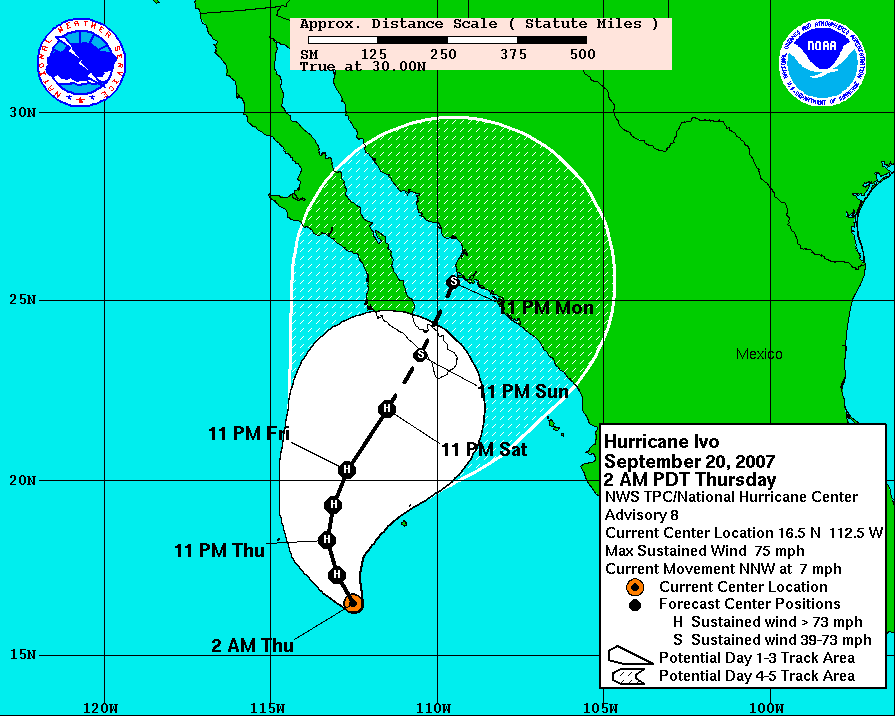 Initially, some forecasts predicted the storm would strike the Baja California Peninsula as a tropical storm. On September 22, uncertainty in predicting Ivo's track and intensity prompted the Mexican Government to issues a tropical storm watch
from Sante Fe to Cabo San Lucas
. At 0900 UTC the next day, the advisory was discontinued, as the storm had weakened substantially before approaching land. In Cabo San Lucas authorities advised residents to stock up on water and food in preparation for potential evacuations. On September 23, before the imminent arrival of Ivo the south coast of Baja California, the director of Civil Protection in the state reported that just over 100 shelters would be cleared for use in the municipalities of Los Cabos, La Paz and Comondú, respectively. The General Coordination of Civil Protection advised shrimp fishing parties to pay close attention to the storm.
No significant effects were reported on land, as the storm dissipated before approaching the coast. However, the remnants spread rainbands over the southern tip of Baja California.
Mexico
The United Mexican States , commonly known as Mexico , is a federal constitutional republic in North America. It is bordered on the north by the United States; on the south and west by the Pacific Ocean; on the southeast by Guatemala, Belize, and the Caribbean Sea; and on the east by the Gulf of...
during mid-September 2007. The 12th tropical cyclone
Tropical cyclone
A tropical cyclone is a storm system characterized by a large low-pressure center and numerous thunderstorms that produce strong winds and heavy rain. Tropical cyclones strengthen when water evaporated from the ocean is released as the saturated air rises, resulting in condensation of water vapor...
, ninth named storm and fourth hurricane of the 2007 Pacific hurricane season
2007 Pacific hurricane season
The 2007 Pacific hurricane season was an event in the annual cycle of tropical cyclone formation. It officially started on May 15, 2007 in the eastern Pacific, designated as the area east of 140°W, and on June 1, 2007 in the central Pacific, which is between the International Date Line and 140°W,...
, Ivo originated from a tropical wave
Tropical wave
Tropical waves, easterly waves, or tropical easterly waves, also known as African easterly waves in the Atlantic region, are a type of atmospheric trough, an elongated area of relatively low air pressure, oriented north to south, which move from east to west across the tropics causing areas of...
that left the coast of Africa
Africa
Africa is the world's second largest and second most populous continent, after Asia. At about 30.2 million km² including adjacent islands, it covers 6% of the Earth's total surface area and 20.4% of the total land area...
on September 1 and traversed the Atlantic, crossing into the Pacific Ocean
Pacific Ocean
The Pacific Ocean is the largest of the Earth's oceanic divisions. It extends from the Arctic in the north to the Southern Ocean in the south, bounded by Asia and Australia in the west, and the Americas in the east.At 165.2 million square kilometres in area, this largest division of the World...
on September 15. The wave subsequently spawned a low pressure system that developed into Tropical Depression 12-E by September 18. After being upgraded to a tropical storm the next day, the cyclone intensified to attain peak winds of 80 mph (128.7 km/h) on September 21, a Category 1 hurricane on the Saffir-Simpson Hurricane Scale
Saffir-Simpson Hurricane Scale
The Saffir–Simpson Hurricane Scale , or the Saffir–Simpson Hurricane Wind Scale , classifies hurricanes — Western Hemisphere tropical cyclones that exceed the intensities of tropical depressions and tropical storms — into five categories distinguished by the intensities of their sustained winds...
. Uncertainty in the storm's track prompted a tropical storm watch
Tropical cyclone warnings and watches
Warnings and watches are two levels of alert issued by national weather forecasting bodies to coastal areas threatened by the imminent approach of a tropical cyclone of tropical storm or hurricane intensity. They are notices to the local population and civil authorities to make appropriate...
to be issued along portions of the coast of Baja California
Baja California
Baja California officially Estado Libre y Soberano de Baja California is one of the 31 states which, with the Federal District, comprise the 32 Federal Entities of Mexico. It is both the northernmost and westernmost state of Mexico. Before becoming a state in 1953, the area was known as the North...
, although the storm never affected land as an active tropical cyclone.
Meteorological history
A tropical waveTropical wave
Tropical waves, easterly waves, or tropical easterly waves, also known as African easterly waves in the Atlantic region, are a type of atmospheric trough, an elongated area of relatively low air pressure, oriented north to south, which move from east to west across the tropics causing areas of...
associated with little or no convection moved off the east coast of Africa
Africa
Africa is the world's second largest and second most populous continent, after Asia. At about 30.2 million km² including adjacent islands, it covers 6% of the Earth's total surface area and 20.4% of the total land area...
on September 1, 2007 and entered the Atlantic Ocean
Atlantic Ocean
The Atlantic Ocean is the second-largest of the world's oceanic divisions. With a total area of about , it covers approximately 20% of the Earth's surface and about 26% of its water surface area...
. The wave traversed the Atlantic, crossing Central America
Central America
Central America is the central geographic region of the Americas. It is the southernmost, isthmian portion of the North American continent, which connects with South America on the southeast. When considered part of the unified continental model, it is considered a subcontinent...
on September 15 where the disturbance began to show signs of organization. The next day, a broad area of low pressure developed within the wave. Continuing to organize, the low became a tropical depression at 0600 UTC on September 16, about 460 mi (740.3 km) south-southwest of Manzanillo, Mexico.
Initially, the exact location of the center of circulation was somewhat uncertain, which led to difficulty in predicting the direction of movement. Located on the southern side of a mid-level ridge extending westward from northern Mexico, the depression was in an environment of light northwesterly wind shear
Wind shear
Wind shear, sometimes referred to as windshear or wind gradient, is a difference in wind speed and direction over a relatively short distance in the atmosphere...
. Subsequently convective bands began to form near the center. Later that day, overall satellite presentation improved, and the cloud pattern became symmetric with excellent outflow. Tracking west-northwestward as a result of the mid-level ridge, the cyclone intensified, and was upgraded to Tropical Storm Ivo early on September 19. Ivo developed a ragged eye, and at 0000 UTC on September 20 it was upgraded to a hurricane as the cyclone began to turn northward. With an area of deep convection near the center, the hurricane reached peak intensity of 80 mph (128.7 km/h) at 1800 UTC. At the time well-defined yet displaced eyewall features were evident. Early on September 21, an eye
Eye (cyclone)
The eye is a region of mostly calm weather found at the center of strong tropical cyclones. The eye of a storm is a roughly circular area and typically 30–65 km in diameter. It is surrounded by the eyewall, a ring of towering thunderstorms where the second most severe weather of a cyclone...
appeared on satellite imagery, but quickly degenerated. At around the same time, the overall structure of the hurricane became ragged, and the storm slowed in forward movement. Westerly flow associated with a large upper-level low pressure system began to undercut the outflow of Ivo, and it weakened to tropical storm status late on September 21.
The convective pattern rapidly deteriorated with the warming of cloud tops, likely due to southeasterly wind shear. After several hours with limited thunderstorm activity, a burst of convection generated to the north of the center, early on September 22. At 0000 UTC on September 23 the storm was downgraded to a tropical depression to the west-southwest of the southern tip of Baja California
Baja California
Baja California officially Estado Libre y Soberano de Baja California is one of the 31 states which, with the Federal District, comprise the 32 Federal Entities of Mexico. It is both the northernmost and westernmost state of Mexico. Before becoming a state in 1953, the area was known as the North...
. Convective activity quickly diminished, and the remnants of Ivo had dissipated entirely later that day, never approaching land as an active tropical cyclone.
Preparations and impact
Tropical cyclone warnings and watches
Warnings and watches are two levels of alert issued by national weather forecasting bodies to coastal areas threatened by the imminent approach of a tropical cyclone of tropical storm or hurricane intensity. They are notices to the local population and civil authorities to make appropriate...
from Sante Fe to Cabo San Lucas
Cabo San Lucas
Cabo San Lucas , commonly called Cabo, is a city at the southern tip of the Baja California peninsula, in the municipality of Los Cabos in the Mexican state of Baja California Sur. As of the 2010 census, the population was 68,463 people...
. At 0900 UTC the next day, the advisory was discontinued, as the storm had weakened substantially before approaching land. In Cabo San Lucas authorities advised residents to stock up on water and food in preparation for potential evacuations. On September 23, before the imminent arrival of Ivo the south coast of Baja California, the director of Civil Protection in the state reported that just over 100 shelters would be cleared for use in the municipalities of Los Cabos, La Paz and Comondú, respectively. The General Coordination of Civil Protection advised shrimp fishing parties to pay close attention to the storm.
No significant effects were reported on land, as the storm dissipated before approaching the coast. However, the remnants spread rainbands over the southern tip of Baja California.
See also
- List of Pacific hurricanes
- Timeline of the 2007 Pacific hurricane seasonTimeline of the 2007 Pacific hurricane seasonThe 2007 Pacific hurricane season was an event in the annual cycle of tropical cyclone formation. This timeline documents all the storm formations, strengthening, weakening, landfalls, extratropical transitions, and dissipation...