
.gif)
Hurricane Cosme (2007)
Encyclopedia
Hurricane Cosme was a minimal hurricane that threatened Hawaii
in mid-July 2007. The sixth tropical cyclone
, third named storm and first hurricane of the 2007 Pacific hurricane season
, Cosme originated from a tropical wave that emerged off the coast of Africa on June 27 and tracked westward before emerging in the eastern Pacific. A system along the wave organized, and it was classified as a tropical depression on July 14, a tropical storm on July 15, and a hurricane on July 16. Cosme reached peak intensity as a Category 1 hurricane on the Saffir-Simpson Hurricane Scale
, but quickly weakened due to cooler waters. Steadily decreasing in strength, the storm was downgraded to a tropical depression before passing to the south of the Hawaiian Islands
. The depression crossed into the Central Pacific and degenerated into a remnant low by July 23.
Because Cosme stayed far from land, effects were mostly minor. Swells up to 9 ft (2.7 m) and up to 6.94 in (176.3 mm) of rainfall were reported, in addition to wind gusts of 40 mph (65 km/h). No fatalities or injuries were reported, and only minimal damage occurred.
that left the coast of Africa
on June 27, 2007. Due to a lack of associated convection
, the wave was difficult to track across the Atlantic Ocean
and Caribbean Sea
. The National Hurricane Center
(NHC) estimated that the wave emerged into the Pacific Ocean
on July 8. Because the system was embedded within the Intertropical Convergence Zone
(ITCZ), development was initially slow. However, when it separated from the ITCZ on July 13, the disturbance increased in convective organization, and was classified as Tropical Depression Six-E about midway between Mexico
and Hawaii
. It tracked westward at 12 mph (19.3 km/h) due to steering currents of a tropical easterly flow. Although wind shear
was generally light, ocean temperatures were only marginal for tropical cyclone intensification
. Forecasters experienced difficulty in locating the exact center of circulation. By July 14, convection had steadily decreased, although the storm's movement was initially uncertain due to its location within a broad low pressure area. Early on July 15 the depression's appearance on satellite imagery
improved, and at 1800 UTC
the NHC upgraded the depression to tropical storm status, and gave it the name
"Cosme".
Shortly after attaining tropical storm status, the previously-broad circulation consolidated as banding features
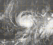
developed. The inner core gradually condensed and tightened, as indicated by an AMSR-E overpass. On July 16 an eye
began to form and Cosme intensified to attain winds of 65 mph (104.6 km/h). Tracking northwest towards a weakness in the mid-level ridge
, the cyclone continued to intensify and was upgraded to Hurricane Cosme late on July 16, about 1600 mi (2,574.9 km) east of Hilo. The hurricane reached peak intensity with winds of 75 mph (120 km/h), although due to cooler waters it quickly weakened to a tropical storm, as the eye became ragged and cloud-filled.
By July 17, the cloud pattern had deteriorated, and its winds decreased to 45 mph (75 km/h). The center subsequently became exposed, with just a few thunderstorms confined to the southwest portion of the storm as it began to accelerate to the west. As easterly vertical wind shear increased, convection temporarily reformed in a concentrated area southwest of the center. As Cosme reached steadily cooler water temperatures, it was downgraded to a tropical depression late on July 18 about 900 mi (1,448.4 km) southeast of Hilo, Hawaii; at around the same time, the storm entered the forecast responsibility of the Central Pacific Hurricane Center
. Tracking westward at 14 mph (22.5 km/h), maximum sustained winds were 35 mph (56.3 km/h) with localized higher gusts. Gradually weakening, Tropical Depression Cosme passed south of the Hawaiian Islands
on July 20 with a minimum central pressure of 1010 mbar
. On July 22, the depression came within 180 mi (289.7 km) of Johnston Island, and later that day, it degenerated into a remnant low.
 Initially, Cosme was predicted to make landfall on Hawaii
as a tropical storm. In anticipation of the storm, the National Weather Service issued a flash flood watch for the island of Hawaii on July 20. Also, small craft advisories were in effect for Maui
and Hawaii; wind advisories were issued for summits in those regions. High surf advisories were also put into effect for coastal areas. The Hawaii County Civil Defense prepared for the storm by planning for increases in emergency response personnel and opening of evacuation centers. County crews worked to clean out drains and culverts to prevent flooding.
Because the depression stayed far from land, the effects were mostly minor and little damage was reported. A strong trade wind
swell north of Cosme generated waves up to 9 ft (2.7 m) high. Rain bands produced up to 6.94 in (176.3 mm) of rainfall, causing small stream and drainage ditch flooding, as well as ponding on roadways in portions of Hilo, Puna, and Kau. The rainfall helped to relieve a persistent drought which had existed for several months. Wind gusts reached 40 mph (65 km/h) in southern portions of Hawaii, causing no known damage.
Hawaii
Hawaii is the newest of the 50 U.S. states , and is the only U.S. state made up entirely of islands. It is the northernmost island group in Polynesia, occupying most of an archipelago in the central Pacific Ocean, southwest of the continental United States, southeast of Japan, and northeast of...
in mid-July 2007. The sixth tropical cyclone
Tropical cyclone
A tropical cyclone is a storm system characterized by a large low-pressure center and numerous thunderstorms that produce strong winds and heavy rain. Tropical cyclones strengthen when water evaporated from the ocean is released as the saturated air rises, resulting in condensation of water vapor...
, third named storm and first hurricane of the 2007 Pacific hurricane season
2007 Pacific hurricane season
The 2007 Pacific hurricane season was an event in the annual cycle of tropical cyclone formation. It officially started on May 15, 2007 in the eastern Pacific, designated as the area east of 140°W, and on June 1, 2007 in the central Pacific, which is between the International Date Line and 140°W,...
, Cosme originated from a tropical wave that emerged off the coast of Africa on June 27 and tracked westward before emerging in the eastern Pacific. A system along the wave organized, and it was classified as a tropical depression on July 14, a tropical storm on July 15, and a hurricane on July 16. Cosme reached peak intensity as a Category 1 hurricane on the Saffir-Simpson Hurricane Scale
Saffir-Simpson Hurricane Scale
The Saffir–Simpson Hurricane Scale , or the Saffir–Simpson Hurricane Wind Scale , classifies hurricanes — Western Hemisphere tropical cyclones that exceed the intensities of tropical depressions and tropical storms — into five categories distinguished by the intensities of their sustained winds...
, but quickly weakened due to cooler waters. Steadily decreasing in strength, the storm was downgraded to a tropical depression before passing to the south of the Hawaiian Islands
Hawaiian Islands
The Hawaiian Islands are an archipelago of eight major islands, several atolls, numerous smaller islets, and undersea seamounts in the North Pacific Ocean, extending some 1,500 miles from the island of Hawaii in the south to northernmost Kure Atoll...
. The depression crossed into the Central Pacific and degenerated into a remnant low by July 23.
Because Cosme stayed far from land, effects were mostly minor. Swells up to 9 ft (2.7 m) and up to 6.94 in (176.3 mm) of rainfall were reported, in addition to wind gusts of 40 mph (65 km/h). No fatalities or injuries were reported, and only minimal damage occurred.
Meteorological history
The origins of Cosme can be traced back to a tropical waveTropical wave
Tropical waves, easterly waves, or tropical easterly waves, also known as African easterly waves in the Atlantic region, are a type of atmospheric trough, an elongated area of relatively low air pressure, oriented north to south, which move from east to west across the tropics causing areas of...
that left the coast of Africa
Africa
Africa is the world's second largest and second most populous continent, after Asia. At about 30.2 million km² including adjacent islands, it covers 6% of the Earth's total surface area and 20.4% of the total land area...
on June 27, 2007. Due to a lack of associated convection
Atmospheric convection
Atmospheric convection is the result of a parcel-environment instability, or temperature difference, layer in the atmosphere. Different lapse rates within dry and moist air lead to instability. Mixing of air during the day which expands the height of the planetary boundary layer leads to...
, the wave was difficult to track across the Atlantic Ocean
Atlantic Ocean
The Atlantic Ocean is the second-largest of the world's oceanic divisions. With a total area of about , it covers approximately 20% of the Earth's surface and about 26% of its water surface area...
and Caribbean Sea
Caribbean Sea
The Caribbean Sea is a sea of the Atlantic Ocean located in the tropics of the Western hemisphere. It is bounded by Mexico and Central America to the west and southwest, to the north by the Greater Antilles, and to the east by the Lesser Antilles....
. The National Hurricane Center
National Hurricane Center
The National Hurricane Center , located at Florida International University in Miami, Florida, is the division of the National Weather Service responsible for tracking and predicting weather systems within the tropics between the Prime Meridian and the 140th meridian west poleward to the 30th...
(NHC) estimated that the wave emerged into the Pacific Ocean
Pacific Ocean
The Pacific Ocean is the largest of the Earth's oceanic divisions. It extends from the Arctic in the north to the Southern Ocean in the south, bounded by Asia and Australia in the west, and the Americas in the east.At 165.2 million square kilometres in area, this largest division of the World...
on July 8. Because the system was embedded within the Intertropical Convergence Zone
Intertropical Convergence Zone
The Intertropical Convergence Zone , known by sailors as The Doldrums, is the area encircling the earth near the equator where winds originating in the northern and southern hemispheres come together....
(ITCZ), development was initially slow. However, when it separated from the ITCZ on July 13, the disturbance increased in convective organization, and was classified as Tropical Depression Six-E about midway between Mexico
Mexico
The United Mexican States , commonly known as Mexico , is a federal constitutional republic in North America. It is bordered on the north by the United States; on the south and west by the Pacific Ocean; on the southeast by Guatemala, Belize, and the Caribbean Sea; and on the east by the Gulf of...
and Hawaii
Hawaii
Hawaii is the newest of the 50 U.S. states , and is the only U.S. state made up entirely of islands. It is the northernmost island group in Polynesia, occupying most of an archipelago in the central Pacific Ocean, southwest of the continental United States, southeast of Japan, and northeast of...
. It tracked westward at 12 mph (19.3 km/h) due to steering currents of a tropical easterly flow. Although wind shear
Wind shear
Wind shear, sometimes referred to as windshear or wind gradient, is a difference in wind speed and direction over a relatively short distance in the atmosphere...
was generally light, ocean temperatures were only marginal for tropical cyclone intensification
Tropical cyclogenesis
Tropical cyclogenesis is the term that describes the development and strengthening of a tropical cyclone in the atmosphere. The mechanisms through which tropical cyclogenesis occurs are distinctly different from those through which mid-latitude cyclogenesis occurs...
. Forecasters experienced difficulty in locating the exact center of circulation. By July 14, convection had steadily decreased, although the storm's movement was initially uncertain due to its location within a broad low pressure area. Early on July 15 the depression's appearance on satellite imagery
Satellite imagery
Satellite imagery consists of photographs of Earth or other planets made by means of artificial satellites.- History :The first images from space were taken on sub-orbital flights. The U.S-launched V-2 flight on October 24, 1946 took one image every 1.5 seconds...
improved, and at 1800 UTC
Coordinated Universal Time
Coordinated Universal Time is the primary time standard by which the world regulates clocks and time. It is one of several closely related successors to Greenwich Mean Time. Computer servers, online services and other entities that rely on having a universally accepted time use UTC for that purpose...
the NHC upgraded the depression to tropical storm status, and gave it the name
Tropical cyclone naming
Tropical cyclones have officially been named since 1945 and are named for a variety of reasons, which include to facilitate communications between forecasters and the public when forecasts, watches, and warnings are issued. Names also reduce confusion about what storm is being described, as more...
"Cosme".
Shortly after attaining tropical storm status, the previously-broad circulation consolidated as banding features
Eye (cyclone)
The eye is a region of mostly calm weather found at the center of strong tropical cyclones. The eye of a storm is a roughly circular area and typically 30–65 km in diameter. It is surrounded by the eyewall, a ring of towering thunderstorms where the second most severe weather of a cyclone...
developed. The inner core gradually condensed and tightened, as indicated by an AMSR-E overpass. On July 16 an eye
Eye (cyclone)
The eye is a region of mostly calm weather found at the center of strong tropical cyclones. The eye of a storm is a roughly circular area and typically 30–65 km in diameter. It is surrounded by the eyewall, a ring of towering thunderstorms where the second most severe weather of a cyclone...
began to form and Cosme intensified to attain winds of 65 mph (104.6 km/h). Tracking northwest towards a weakness in the mid-level ridge
Ridge (meteorology)
A ridge is an elongated region of relatively high atmospheric pressure, the opposite of a trough....
, the cyclone continued to intensify and was upgraded to Hurricane Cosme late on July 16, about 1600 mi (2,574.9 km) east of Hilo. The hurricane reached peak intensity with winds of 75 mph (120 km/h), although due to cooler waters it quickly weakened to a tropical storm, as the eye became ragged and cloud-filled.
By July 17, the cloud pattern had deteriorated, and its winds decreased to 45 mph (75 km/h). The center subsequently became exposed, with just a few thunderstorms confined to the southwest portion of the storm as it began to accelerate to the west. As easterly vertical wind shear increased, convection temporarily reformed in a concentrated area southwest of the center. As Cosme reached steadily cooler water temperatures, it was downgraded to a tropical depression late on July 18 about 900 mi (1,448.4 km) southeast of Hilo, Hawaii; at around the same time, the storm entered the forecast responsibility of the Central Pacific Hurricane Center
Central Pacific Hurricane Center
The Central Pacific Hurricane Center of the United States National Weather Service is the official body responsible for tracking and issuing tropical cyclone warnings, watches, advisories, discussions, and statements for the Central North Pacific Basin...
. Tracking westward at 14 mph (22.5 km/h), maximum sustained winds were 35 mph (56.3 km/h) with localized higher gusts. Gradually weakening, Tropical Depression Cosme passed south of the Hawaiian Islands
Hawaiian Islands
The Hawaiian Islands are an archipelago of eight major islands, several atolls, numerous smaller islets, and undersea seamounts in the North Pacific Ocean, extending some 1,500 miles from the island of Hawaii in the south to northernmost Kure Atoll...
on July 20 with a minimum central pressure of 1010 mbar
Bar (unit)
The bar is a unit of pressure equal to 100 kilopascals, and roughly equal to the atmospheric pressure on Earth at sea level. Other units derived from the bar are the megabar , kilobar , decibar , centibar , and millibar...
. On July 22, the depression came within 180 mi (289.7 km) of Johnston Island, and later that day, it degenerated into a remnant low.
Preparations and impact
Hawaii
Hawaii is the newest of the 50 U.S. states , and is the only U.S. state made up entirely of islands. It is the northernmost island group in Polynesia, occupying most of an archipelago in the central Pacific Ocean, southwest of the continental United States, southeast of Japan, and northeast of...
as a tropical storm. In anticipation of the storm, the National Weather Service issued a flash flood watch for the island of Hawaii on July 20. Also, small craft advisories were in effect for Maui
Maui
The island of Maui is the second-largest of the Hawaiian Islands at and is the 17th largest island in the United States. Maui is part of the state of Hawaii and is the largest of Maui County's four islands, bigger than Lānai, Kahoolawe, and Molokai. In 2010, Maui had a population of 144,444,...
and Hawaii; wind advisories were issued for summits in those regions. High surf advisories were also put into effect for coastal areas. The Hawaii County Civil Defense prepared for the storm by planning for increases in emergency response personnel and opening of evacuation centers. County crews worked to clean out drains and culverts to prevent flooding.
Because the depression stayed far from land, the effects were mostly minor and little damage was reported. A strong trade wind
Trade wind
The trade winds are the prevailing pattern of easterly surface winds found in the tropics, within the lower portion of the Earth's atmosphere, in the lower section of the troposphere near the Earth's equator...
swell north of Cosme generated waves up to 9 ft (2.7 m) high. Rain bands produced up to 6.94 in (176.3 mm) of rainfall, causing small stream and drainage ditch flooding, as well as ponding on roadways in portions of Hilo, Puna, and Kau. The rainfall helped to relieve a persistent drought which had existed for several months. Wind gusts reached 40 mph (65 km/h) in southern portions of Hawaii, causing no known damage.
See also
- List of Hawaii hurricanes
- Other tropical cyclones named Cosme
- Timeline of the 2007 Pacific hurricane seasonTimeline of the 2007 Pacific hurricane seasonThe 2007 Pacific hurricane season was an event in the annual cycle of tropical cyclone formation. This timeline documents all the storm formations, strengthening, weakening, landfalls, extratropical transitions, and dissipation...