

Hoh River
Encyclopedia
The Hoh River is a river in the U.S. state
of Washington, located on the Olympic Peninsula
. About 56 miles (90.1 km) long, the Hoh River originates at the Hoh Glacier
on Mount Olympus
and flows west through the Olympic Mountains
of Olympic National Park
and Olympic National Forest
, then through the foothills in a broad valley, emptying into the Pacific Ocean
at the Hoh Indian Reservation
. The final portion of the Hoh River's course marks the boundary between the coastal segment of Olympic National Park and Olympic National Forest
, the Hoh Indian Reservation.
The Hoh's drainage basin
is 299 square miles (774.4 km²). Its discharge
, or streamflow
has considerable seasonal variation, with summer streamflow averaging about one-third that of winter flows.
The Hoh is a glacial river fed by glaciers on Mount Olympus, such as the Blue Glacier
. The glaciers grind rock into a fine glacial flour which turns the Hoh River a milky slate blue color. The river valley is generally broad and relatively flat, causing the glacial sediments to settle out, creating extensive gravel bars, river meanders, and the many side channels characteristic of a braided river
.
One of the road entrances to Olympic National Park is on the Hoh River. The Hoh River Campground is the trailhead of the Hoh River Trail, which follows the river through the Hoh Rain Forest from the campground to Mount Olympus. Logjams are common, resulting in quiet pools and new river channels being formed.
The river's name and the name of the Hoh tribe both ultimately come from the Quinault placename /húxw/.
on the northeast side of Mount Olympus. The river flows north then west, curving around the north side of the mountain. It collects headwater tributaries from other glaciers on Mount Olympus such as the Ice River, which flows from the Ice River Glacier
, and Glacier Creek, which flows from Blue Glacier
and White Glacier
. Mount Tom Creek, a tributary which joins the Hoh farther downstream, flows from the White Glacier as well. Other headwater tributaries include Elkhorn Creek and Cream Lake Creek, both of which flow west from the Bailey Range of the Olympic Mountains. Ice River joins shortly below Cream Lake Creek. A few miles below that the Hoh River begins to flow more directly west. Glacier Creek joins from the south, from Mount Olympus. About a mile below Glacier Creek, at approximately Hoh river mile
48, the valley broadens and the river begins to take on braided characteristics. Falls Creek joins from the south, then Slate Creek and Hoh Creek from the north.
Olympus Ranger Station, a National Park Service
cabin, is located on the north side of the river at approximately river mile 45, near the junction of the Hoh River Trail and the Hoh Lake Trail. At river mile 42 the Happy Four backcountry camping area is located along the river trail. Below that the tributary Cougar Creek joins from the north, then Mount Tom Creek from the south. Jackson Creek joins from the south at approximately river mile 37 near the Hoh Rain Forest Visitor Center and campground. The Visitor Center is located at the end of Upper Hoh Road and the beginning of the Hoh River Trail. The Upper Hoh Road runs east from U.S. Highway 101, paralleling the Hoh River from Willoughby Creek Campground to the national park. In the region near the national park boundary the Hoh River occupies a U-shaped valley with a flat bottom about one mile across. Mountain slopes rise steeply on either side.
The Hoh River continues flowing west, collecting numerous tributary streams, the most important being the South Fork Hoh River, which joins the main Hoh at about river mile 31. About a mile below the South Fork confluence the Hoh River leaves Olympic National Park. It continues to flow west through a widening valley surrounded by low mountains and foothills. Ranches occupy parts of the valley and land ownership is generally private. Owl Creek and Maple Creek join from the south. The Hoh makes a small northward bend, skirting the edge of, and briefly entering Olympic National Forest
. Elk Creek joins from the south, then Alder Creek from the north, then Winfield Creek from the south, after which the Hoh River flows through a large horseshoe bend located at about river mile 15. Hell Roaring Creek joins the horseshoe bend from the north. Three campgrounds are sited along the river upstream from the horseshoe bend, including Minnie Peterson, Willoughby Creek, and Hoh Oxbow. All three are managed by Washington State Department of Natural Resources (DNR). Hoh Ox Bow Campground is located just west of the horseshoe bend near where U.S. Highway 101 crosses the river. Highway 101 follows the river on the south side. The small Oil City Road follows the Hoh River on the north side to the river's mouth. Cottonwood Campground, another DNR site, is on the north side of the Hoh River, accessed by Oil City Road.
Below the horseshoe bend the Hoh River begins to meander widely through a broad and flat floodplain. In its final miles the Hoh River collects the tributaries Fletcher Creek and Fossil Creek. Highway 101 leaves the river and heads south. About two miles from its mouth the Hoh River becomes the boundary between the Hoh Indian Reservation, on the south, and the coastal part of Olympic National Park on the north. The former settlement of Oil City is located on the north side of the Hoh River about a half mile from its mouth. A large headland peninsula called Hoh Head is located on the Pacific coast a few miles north of the river's mouth.
and other small glaciers on the south side of Mount Olympus. It flows generally west through Olympic National Park collecting many tributary streams. At about river mile 11 it enters a broad glacially carved U-shaped valley and becomes braided. The South Fork leaves Olympic National Park at approximately river mile 4, entering Olympic National Forest. It turns slightly northwest and joins the main Hoh River at approximately Hoh river mile 31. South Fork Campground, managed by Washington State DNR, is located on the South Fork. The road to the campground continues up the South Fork Hoh River to the South Fork Hoh Trailhead, just west of the national park boundary.
chalat' . Their name for the Hoh River is chalak'ac'it .
The earliest documented encounter between Europeans and the Hoh people occurred in 1787 when the British fur trader Charles William Barkley
, captain of the Imperial Eagle
, dispatched a boat up the Hoh River to trade with the natives. The boat's crew of six were killed by the Hoh people, according to European histories. The incident led to the naming of Destruction Island. Barkley named the river Destruction River, but the name became attached to the island instead. The Hoh people deny the story, saying they never massacred ship-wrecked sailors.
In 1808 the Russian American Company set two vessels south from Alaska as part of an effort to expand Russian control south to the Columbia River
and beyond. One of the vessels, the schooner SV Nikolai ran aground at Rialto Beach, north of the Quillayute River
. Tension between the crew and the local Quileutes led to battle. The Russians fled south along the coast to the mouth of the Hoh River where many were captured and taken captive by the Hoh people. Those who evaded capture fled up the Hoh River. They built a small blockhouse and survived into the winter. In February they surrendered to the Hoh tribe at the mouth of the Hoh River. The captives were exchanged and traded among the coastal tribes, with most ending up with the Makah in the Neah Bay
area. In 1810 the Lydia, commanded by Captain T. Brown, an American working for the Russian American Company, sailed into Neah Bay. The thirteen surviving captives being held by the Makah were ransomed by Captain Brown, who then returned them to Sitka.
In the 1850s Isaac Stevens
, the first governor of Washington Territory
, began negotiations with the tribes of the Olympic Peninsula with the goal of obtaining land cessions and creating Indian reservations. In 1855 a treaty was signed by representatives of the Quinault
, Queets, Quileute, and Hoh. The negotiations were done in the trade pidgin
language Chinook Jargon
. The treaty, known as the Treaty of Olympia (or the Quinault River Treaty), was ratified by Congress in 1859. Its terms included the cession of most of the western Olympic Peninsula to the U.S. federal government with a reserve to be determined later. The Quinault Indian Reservation was established in 1863 and the treaty signature tribes were expected to move there. The Hoh, however, refused to move. In 1872 the Indian agent R.H. Milroy explained that the Hoh did not believe they had agreed to cede their land and that the treaty signed had been explained to them as being an agreement about keeping peace with U.S. citizens and allowing them to enter the Hoh's territory and trade for furs. In 1893 President Grover Cleveland
signed an executive order estalishing the Hoh Reservation on the south side of the mouth of the Hoh River.
Early pioneers wishing to settle in the Hoh River valley faced numerous challenges including the dense forest and enormous trees, regular large-scale flooding, isolation from markets, and the impracticality of navigating the Hoh River due to its swift current, floods, and frequent logjams. Nevertheless, land relatively far upriver was settled. The area now within Olympic National Park was never inhabited by non-indigenous people. By 1900 the population in the Hoh River Valley was enough to warrant two post offices, one established in 1897, the other in 1904. Over time the population dwindled. By 1919 there were few people left. Abandoned structures rapidly deteriorated in the wet environment. The few historic structures that used to exist in the Hoh River Valley are entirely gone today.
On the north side of the mouth of the Hoh River, across from the Hoh Indian Reservation, the small settlement of Oil City was established in the 1930s. Oil drilling operations were conducted at the town and north near Hoh Head. The project was abandoned before 1940. A new search for oil drilling potential in the 1970s failed to discover anything commercially viable. Today Oil City is nothing more than a patch of sword ferns at the end of Oil City Road.
, a relatively rare example of a temperate rain forest
. Abundant winter rainfall results in a lush green canopy of coniferous and deciduous trees, often covered with mosses and ferns. Annual precipitation is 140 to 170 in (3,556 to 4,318 mm). According to the National Park Service the Hoh Rain Forest is one of the finest remaining examples of temperate rain forest in the United States. It is one of the most popular destinations of Olympic National Park. Giant Western Hemlock, Douglas-fir
, Thuja plicata (Western Red Cedar), and Sitka Spruce trees dominate the landscape, while ferns and mosses cloak the trees and forest floor. Fallen trees often become nurse log
s.
When Olympic National Park was created in 1938 one of its primary objectives was to protect the herds of Roosevelt elk
. Today about 400 of the park's 4,000-5,000 elk live in the Hoh River valley.
The Hoh River supports a variety of salmonid
fish, including spring and fall chinook
, coho
salmon, winter and summer steelhead trout, and sea-run cutthroat trout
. There are also smaller numbers of chum
and sockeye
salmon. The Hoh River fishery is managed by the Hoh tribe in cooperation with the Washington Department of Fisheries.
(171.7 sq mi (444.7 km²)), 24.4% state (72.6 sq mi (188 km²)), 17.6% private (52.5 sq mi (136 km²)), 0.22% National Forest
(0.64 sq mi (1.7 km²)), and 0.21% Hoh Indian Reservation
(0.63 sq mi (1.6 km²)).
 The Hoh River Trail, managed by the National Park Service, begins at the national park's Hoh Rain Forest Visitor Center at the end of the Upper Hoh Road. The trail follows the Hoh River east into the heart of the park. After 17.5 mi (28.2 km) it reaches Glacier Meadows near Mount Olympus's Blue Glacier
. The Hoh River Trail begins at an altitude of about 600 ft (182.9 m) and the trail is mostly flat for about 13 mi (20.9 km), after which it ascends steeply to Glacier Meadows, altitude 4300 ft (1,310.6 m). The trail passes through the Hoh Rain Forest, a temperate rain forest
, and, closer to Mount Olympus, montane
forests and subalpine
meadows. There are a number of backcountry campsites along the trail. Mountaineers
wishing to climb Mount Olympus typically use the Hoh River Trail to reach the mountain. The climb requires experience with glacier travel and crevasse rescue
skills.
The Hoh Lake Trail branches off from the Hoh River Trail near the Olympus Ranger Station and ascends to Hoh Lake and Bogachiel Peak
, then across High Divide into the Sol Duc River
valley.
The Oil City Trail, managed by Olympic National Park, begins on the north side of the mouth of the Hoh River and runs about a mile to the Pacific coast. People can hike north along the coast to Hoh Head and beyond.
U.S. state
A U.S. state is any one of the 50 federated states of the United States of America that share sovereignty with the federal government. Because of this shared sovereignty, an American is a citizen both of the federal entity and of his or her state of domicile. Four states use the official title of...
of Washington, located on the Olympic Peninsula
Olympic Peninsula
The Olympic Peninsula is the large arm of land in western Washington state of the USA, that lies across Puget Sound from Seattle. It is bounded on the west by the Pacific Ocean, the north by the Strait of Juan de Fuca, and the east by Puget Sound. Cape Alava, the westernmost point in the contiguous...
. About 56 miles (90.1 km) long, the Hoh River originates at the Hoh Glacier
Hoh Glacier
Hoh Glacier is a glacier on Mount Olympus in the Olympic National Park in Jefferson County of the U.S. state of Washington. It is the source of the Hoh River. Hoh Glacier is the longest glacier on Mount Olympus at , though it is smaller in volume than Blue Glacier....
on Mount Olympus
Mount Olympus (Washington)
Mount Olympus is the tallest and most prominent mountain in the Olympic Mountains of western Washington state. Located on the Olympic Peninsula, it is the central feature of Olympic National Park. Mount Olympus is the highest summit of the Olympic Mountains, however, peaks such as Mount Constance,...
and flows west through the Olympic Mountains
Olympic Mountains
The Olympic Mountains is a mountain range on the Olympic Peninsula of western Washington in the United States. The mountains, part of the Pacific Coast Ranges, are not especially high - Mount Olympus is the highest at - but the western slopes of the Olympics rise directly out of the Pacific...
of Olympic National Park
Olympic National Park
Olympic National Park is located in the U.S. state of Washington, in the Olympic Peninsula. The park can be divided into four basic regions: the Pacific coastline, alpine areas, the west side temperate rainforest and the forests of the drier east side. U.S...
and Olympic National Forest
Olympic National Forest
Olympic National Forest is a U.S. National Forest located in Washington, USA. With an area of 633,677 acres , it nearly surrounds Olympic National Park and the Olympic Mountain range. Olympic National Forest contains parts of Clallam, Grays Harbor, Jefferson, and Mason counties...
, then through the foothills in a broad valley, emptying into the Pacific Ocean
Pacific Ocean
The Pacific Ocean is the largest of the Earth's oceanic divisions. It extends from the Arctic in the north to the Southern Ocean in the south, bounded by Asia and Australia in the west, and the Americas in the east.At 165.2 million square kilometres in area, this largest division of the World...
at the Hoh Indian Reservation
Hoh
Hoh is a Native American tribe in western Washington state in the United States. The tribe lives on the Pacific Coast of Washington on the Olympic Peninsula. The Hoh moved onto the Hoh Indian Reservation, at the mouth of the Hoh River, on the Pacific Coast of Jefferson County, after the signing...
. The final portion of the Hoh River's course marks the boundary between the coastal segment of Olympic National Park and Olympic National Forest
Olympic National Forest
Olympic National Forest is a U.S. National Forest located in Washington, USA. With an area of 633,677 acres , it nearly surrounds Olympic National Park and the Olympic Mountain range. Olympic National Forest contains parts of Clallam, Grays Harbor, Jefferson, and Mason counties...
, the Hoh Indian Reservation.
The Hoh's drainage basin
Drainage basin
A drainage basin is an extent or an area of land where surface water from rain and melting snow or ice converges to a single point, usually the exit of the basin, where the waters join another waterbody, such as a river, lake, reservoir, estuary, wetland, sea, or ocean...
is 299 square miles (774.4 km²). Its discharge
Discharge (hydrology)
In hydrology, discharge is the volume rate of water flow, including any suspended solids , dissolved chemical species and/or biologic material , which is transported through a given cross-sectional area...
, or streamflow
Streamflow
Streamflow, or channel runoff, is the flow of water in streams, rivers, and other channels, and is a major element of the water cycle. It is one component of the runoff of water from the land to waterbodies, the other component being surface runoff...
has considerable seasonal variation, with summer streamflow averaging about one-third that of winter flows.
The Hoh is a glacial river fed by glaciers on Mount Olympus, such as the Blue Glacier
Blue Glacier
Blue Glacier is a large glacier located to the north of Mount Olympus in the Olympic Mountains of Washington. The glacier covers an area of and contains of ice and snow in spite of its low terminus elevation...
. The glaciers grind rock into a fine glacial flour which turns the Hoh River a milky slate blue color. The river valley is generally broad and relatively flat, causing the glacial sediments to settle out, creating extensive gravel bars, river meanders, and the many side channels characteristic of a braided river
Braided river
A braided river is one of a number of channel types and has a channel that consists of a network of small channels separated by small and often temporary islands called braid bars or, in British usage, aits or eyots. Braided streams occur in rivers with high slope and/or large sediment load...
.
One of the road entrances to Olympic National Park is on the Hoh River. The Hoh River Campground is the trailhead of the Hoh River Trail, which follows the river through the Hoh Rain Forest from the campground to Mount Olympus. Logjams are common, resulting in quiet pools and new river channels being formed.
The river's name and the name of the Hoh tribe both ultimately come from the Quinault placename /húxw/.
Course
The source of the Hoh River is meltwater from the Hoh GlacierHoh Glacier
Hoh Glacier is a glacier on Mount Olympus in the Olympic National Park in Jefferson County of the U.S. state of Washington. It is the source of the Hoh River. Hoh Glacier is the longest glacier on Mount Olympus at , though it is smaller in volume than Blue Glacier....
on the northeast side of Mount Olympus. The river flows north then west, curving around the north side of the mountain. It collects headwater tributaries from other glaciers on Mount Olympus such as the Ice River, which flows from the Ice River Glacier
Ice River Glacier
Ice River Glacier is a glacier located near Mount Olympus in the Olympic Mountains and Olympic National Park. Starting at an elevation of on the northern slope of a peak, the glacier flows northwest as the ice descends. The glacier reaches as low as before terminating. Though the glacier lies...
, and Glacier Creek, which flows from Blue Glacier
Blue Glacier
Blue Glacier is a large glacier located to the north of Mount Olympus in the Olympic Mountains of Washington. The glacier covers an area of and contains of ice and snow in spite of its low terminus elevation...
and White Glacier
White Glacier (Mount Tom)
White Glacier is a medium-sized glacier located to the northeast of Mount Tom in the Olympic Mountains and Olympic National Park, Washington state, United States. The glacier, located in between Mount Tom and Mount Olympus, starts at around...
. Mount Tom Creek, a tributary which joins the Hoh farther downstream, flows from the White Glacier as well. Other headwater tributaries include Elkhorn Creek and Cream Lake Creek, both of which flow west from the Bailey Range of the Olympic Mountains. Ice River joins shortly below Cream Lake Creek. A few miles below that the Hoh River begins to flow more directly west. Glacier Creek joins from the south, from Mount Olympus. About a mile below Glacier Creek, at approximately Hoh river mile
River mile
In the United States, a River mile is a measure of distance in miles along a river from its mouth. River mile numbers begin at zero and increase further upstream. The corresponding metric unit using kilometers is the River kilometer...
48, the valley broadens and the river begins to take on braided characteristics. Falls Creek joins from the south, then Slate Creek and Hoh Creek from the north.
Olympus Ranger Station, a National Park Service
National Park Service
The National Park Service is the U.S. federal agency that manages all national parks, many national monuments, and other conservation and historical properties with various title designations...
cabin, is located on the north side of the river at approximately river mile 45, near the junction of the Hoh River Trail and the Hoh Lake Trail. At river mile 42 the Happy Four backcountry camping area is located along the river trail. Below that the tributary Cougar Creek joins from the north, then Mount Tom Creek from the south. Jackson Creek joins from the south at approximately river mile 37 near the Hoh Rain Forest Visitor Center and campground. The Visitor Center is located at the end of Upper Hoh Road and the beginning of the Hoh River Trail. The Upper Hoh Road runs east from U.S. Highway 101, paralleling the Hoh River from Willoughby Creek Campground to the national park. In the region near the national park boundary the Hoh River occupies a U-shaped valley with a flat bottom about one mile across. Mountain slopes rise steeply on either side.
The Hoh River continues flowing west, collecting numerous tributary streams, the most important being the South Fork Hoh River, which joins the main Hoh at about river mile 31. About a mile below the South Fork confluence the Hoh River leaves Olympic National Park. It continues to flow west through a widening valley surrounded by low mountains and foothills. Ranches occupy parts of the valley and land ownership is generally private. Owl Creek and Maple Creek join from the south. The Hoh makes a small northward bend, skirting the edge of, and briefly entering Olympic National Forest
Olympic National Forest
Olympic National Forest is a U.S. National Forest located in Washington, USA. With an area of 633,677 acres , it nearly surrounds Olympic National Park and the Olympic Mountain range. Olympic National Forest contains parts of Clallam, Grays Harbor, Jefferson, and Mason counties...
. Elk Creek joins from the south, then Alder Creek from the north, then Winfield Creek from the south, after which the Hoh River flows through a large horseshoe bend located at about river mile 15. Hell Roaring Creek joins the horseshoe bend from the north. Three campgrounds are sited along the river upstream from the horseshoe bend, including Minnie Peterson, Willoughby Creek, and Hoh Oxbow. All three are managed by Washington State Department of Natural Resources (DNR). Hoh Ox Bow Campground is located just west of the horseshoe bend near where U.S. Highway 101 crosses the river. Highway 101 follows the river on the south side. The small Oil City Road follows the Hoh River on the north side to the river's mouth. Cottonwood Campground, another DNR site, is on the north side of the Hoh River, accessed by Oil City Road.
Below the horseshoe bend the Hoh River begins to meander widely through a broad and flat floodplain. In its final miles the Hoh River collects the tributaries Fletcher Creek and Fossil Creek. Highway 101 leaves the river and heads south. About two miles from its mouth the Hoh River becomes the boundary between the Hoh Indian Reservation, on the south, and the coastal part of Olympic National Park on the north. The former settlement of Oil City is located on the north side of the Hoh River about a half mile from its mouth. A large headland peninsula called Hoh Head is located on the Pacific coast a few miles north of the river's mouth.
South Fork
The South Fork Hoh River originates originates at 47°46′53"N 123°43′2"W, flowing from Hubert GlacierHubert Glacier
Hubert Glacier is a medium-sized glacier located on the south side of Mount Olympus in the Olympic Mountains and Olympic National Park. Due to its southern orientation, the glacier is smaller than those on the north side of Mount Olympus, such as Blue Glacier....
and other small glaciers on the south side of Mount Olympus. It flows generally west through Olympic National Park collecting many tributary streams. At about river mile 11 it enters a broad glacially carved U-shaped valley and becomes braided. The South Fork leaves Olympic National Park at approximately river mile 4, entering Olympic National Forest. It turns slightly northwest and joins the main Hoh River at approximately Hoh river mile 31. South Fork Campground, managed by Washington State DNR, is located on the South Fork. The road to the campground continues up the South Fork Hoh River to the South Fork Hoh Trailhead, just west of the national park boundary.
History
The indigenous people of the Hoh River are known as the Hoh but they call themselvesThe earliest documented encounter between Europeans and the Hoh people occurred in 1787 when the British fur trader Charles William Barkley
Charles William Barkley
Charles William Barkley was a ship captain and maritime fur trader. He was born in Hertford, England, son of Charles Barkley....
, captain of the Imperial Eagle
Imperial Eagle (ship)
The Imperial Eagle was a 400 ton burthen British merchant ship that sailed on maritime fur trading ventures in the late 1780s. It was under the command of Captain Charles William Barkley until confiscated in India. The ship, Loudoun, was a decommissioned East Indiaman...
, dispatched a boat up the Hoh River to trade with the natives. The boat's crew of six were killed by the Hoh people, according to European histories. The incident led to the naming of Destruction Island. Barkley named the river Destruction River, but the name became attached to the island instead. The Hoh people deny the story, saying they never massacred ship-wrecked sailors.
In 1808 the Russian American Company set two vessels south from Alaska as part of an effort to expand Russian control south to the Columbia River
Columbia River
The Columbia River is the largest river in the Pacific Northwest region of North America. The river rises in the Rocky Mountains of British Columbia, Canada, flows northwest and then south into the U.S. state of Washington, then turns west to form most of the border between Washington and the state...
and beyond. One of the vessels, the schooner SV Nikolai ran aground at Rialto Beach, north of the Quillayute River
Quillayute River
The Quillayute River is a river situated on the Olympic Peninsula in Washington. It empties to the Pacific Ocean at La Push, Washington. The Quillayute River is formed by the confluence of the Bogachiel River and the Sol Duc River...
. Tension between the crew and the local Quileutes led to battle. The Russians fled south along the coast to the mouth of the Hoh River where many were captured and taken captive by the Hoh people. Those who evaded capture fled up the Hoh River. They built a small blockhouse and survived into the winter. In February they surrendered to the Hoh tribe at the mouth of the Hoh River. The captives were exchanged and traded among the coastal tribes, with most ending up with the Makah in the Neah Bay
Neah Bay, Washington
Neah Bay is a census-designated place on the Makah Indian reservation in Clallam County, Washington, United States. The population was 794 at the 2000 census.-Geography:Neah Bay is located at ....
area. In 1810 the Lydia, commanded by Captain T. Brown, an American working for the Russian American Company, sailed into Neah Bay. The thirteen surviving captives being held by the Makah were ransomed by Captain Brown, who then returned them to Sitka.
In the 1850s Isaac Stevens
Isaac Stevens
Isaac Ingalls Stevens was the first governor of Washington Territory, a United States Congressman, and a brigadier general in the Union Army during the American Civil War until his death at the Battle of Chantilly...
, the first governor of Washington Territory
Washington Territory
The Territory of Washington was an organized incorporated territory of the United States that existed from February 8, 1853, until November 11, 1889, when the final extent of the territory was admitted to the Union as the State of Washington....
, began negotiations with the tribes of the Olympic Peninsula with the goal of obtaining land cessions and creating Indian reservations. In 1855 a treaty was signed by representatives of the Quinault
Quinault (tribe)
The Quinault are a group of Native American peoples from western Washington in the United States.-Lands:The Quinault Indian Reservation, at , is located on the Pacific coast of Washington, primarily in northwestern Grays Harbor County, with small parts extending north into southwestern Jefferson...
, Queets, Quileute, and Hoh. The negotiations were done in the trade pidgin
Pidgin
A pidgin , or pidgin language, is a simplified language that develops as a means of communication between two or more groups that do not have a language in common. It is most commonly employed in situations such as trade, or where both groups speak languages different from the language of the...
language Chinook Jargon
Chinook Jargon
Chinook Jargon originated as a pidgin trade language of the Pacific Northwest, and spread during the 19th century from the lower Columbia River, first to other areas in modern Oregon and Washington, then British Columbia and as far as Alaska, sometimes taking on characteristics of a creole language...
. The treaty, known as the Treaty of Olympia (or the Quinault River Treaty), was ratified by Congress in 1859. Its terms included the cession of most of the western Olympic Peninsula to the U.S. federal government with a reserve to be determined later. The Quinault Indian Reservation was established in 1863 and the treaty signature tribes were expected to move there. The Hoh, however, refused to move. In 1872 the Indian agent R.H. Milroy explained that the Hoh did not believe they had agreed to cede their land and that the treaty signed had been explained to them as being an agreement about keeping peace with U.S. citizens and allowing them to enter the Hoh's territory and trade for furs. In 1893 President Grover Cleveland
Grover Cleveland
Stephen Grover Cleveland was the 22nd and 24th president of the United States. Cleveland is the only president to serve two non-consecutive terms and therefore is the only individual to be counted twice in the numbering of the presidents...
signed an executive order estalishing the Hoh Reservation on the south side of the mouth of the Hoh River.
Early pioneers wishing to settle in the Hoh River valley faced numerous challenges including the dense forest and enormous trees, regular large-scale flooding, isolation from markets, and the impracticality of navigating the Hoh River due to its swift current, floods, and frequent logjams. Nevertheless, land relatively far upriver was settled. The area now within Olympic National Park was never inhabited by non-indigenous people. By 1900 the population in the Hoh River Valley was enough to warrant two post offices, one established in 1897, the other in 1904. Over time the population dwindled. By 1919 there were few people left. Abandoned structures rapidly deteriorated in the wet environment. The few historic structures that used to exist in the Hoh River Valley are entirely gone today.
On the north side of the mouth of the Hoh River, across from the Hoh Indian Reservation, the small settlement of Oil City was established in the 1930s. Oil drilling operations were conducted at the town and north near Hoh Head. The project was abandoned before 1940. A new search for oil drilling potential in the 1970s failed to discover anything commercially viable. Today Oil City is nothing more than a patch of sword ferns at the end of Oil City Road.
Natural history
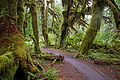
A significant part of the Hoh River flows through the Hoh RainforestHoh Rainforest
The Hoh Rainforest is located on the Olympic Peninsula in western Washington state, USA. It is one of the few temperate rainforests in the U.S., and also one of the largest. Within Olympic National Park, the forest is protected from commercial exploitation. This includes of low elevation forest ...
, a relatively rare example of a temperate rain forest
Temperate rain forest
Temperate rainforests are coniferous or broadleaf forests that occur in the temperate zone and receive high rainfall.-Definition:For temperate rain forests of North America, Alaback's definition is widely recognized:-Global distribution:...
. Abundant winter rainfall results in a lush green canopy of coniferous and deciduous trees, often covered with mosses and ferns. Annual precipitation is 140 to 170 in (3,556 to 4,318 mm). According to the National Park Service the Hoh Rain Forest is one of the finest remaining examples of temperate rain forest in the United States. It is one of the most popular destinations of Olympic National Park. Giant Western Hemlock, Douglas-fir
Douglas-fir
Douglas-fir is one of the English common names for evergreen coniferous trees of the genus Pseudotsuga in the family Pinaceae. Other common names include Douglas tree, and Oregon pine. There are five species, two in western North America, one in Mexico, and two in eastern Asia...
, Thuja plicata (Western Red Cedar), and Sitka Spruce trees dominate the landscape, while ferns and mosses cloak the trees and forest floor. Fallen trees often become nurse log
Nurse log
A nurse log is a fallen tree which, as it decays, provides ecological facilitation to seedlings. Broader definitions include providing shade or support to other plants. Some of the advantages a nurse log offers to a seedling are: water, moss thickness, leaf litter, mycorrhizae, disease protection,...
s.
When Olympic National Park was created in 1938 one of its primary objectives was to protect the herds of Roosevelt elk
Roosevelt elk
The Roosevelt elk , also known as Olympic elk, is the largest of the four surviving subspecies of elk in North America...
. Today about 400 of the park's 4,000-5,000 elk live in the Hoh River valley.
The Hoh River supports a variety of salmonid
Salmonidae
Salmonidae is a family of ray-finned fish, the only living family currently placed in the order Salmoniformes. It includes salmon, trout, chars, freshwater whitefishes and graylings...
fish, including spring and fall chinook
Chinook salmon
The Chinook salmon, Oncorhynchus tshawytscha, is the largest species in the pacific salmon family. Other commonly used names for the species include King salmon, Quinnat salmon, Spring salmon and Tyee salmon...
, coho
Coho salmon
The Coho salmon, Oncorhynchus kisutch, is a species of anadromous fish in the salmon family. Coho salmon are also known as silver salmon or "silvers". It is the state animal of Chiba, Japan.-Description:...
salmon, winter and summer steelhead trout, and sea-run cutthroat trout
Cutthroat trout
The cutthroat trout is a species of freshwater fish in the salmon family of order Salmoniformes. It is one of the many fish species colloquially known as trout...
. There are also smaller numbers of chum
Chum salmon
The chum salmon, Oncorhynchus keta, is a species of anadromous fish in the salmon family. It is a Pacific salmon, and may also be known as dog salmon or Keta salmon, and is often marketed under the name Silverbrite salmon...
and sockeye
Sockeye salmon
Sockeye salmon , also called red salmon or blueback salmon in the USA, is an anadromous species of salmon found in the Northern Pacific Ocean and rivers discharging into it...
salmon. The Hoh River fishery is managed by the Hoh tribe in cooperation with the Washington Department of Fisheries.
Land use
Land administration within the Hoh River's watershed, approximately, is 57.6% National Park ServiceNational Park Service
The National Park Service is the U.S. federal agency that manages all national parks, many national monuments, and other conservation and historical properties with various title designations...
(171.7 sq mi (444.7 km²)), 24.4% state (72.6 sq mi (188 km²)), 17.6% private (52.5 sq mi (136 km²)), 0.22% National Forest
United States National Forest
National Forest is a classification of federal lands in the United States.National Forests are largely forest and woodland areas owned by the federal government and managed by the United States Forest Service, part of the United States Department of Agriculture. Land management of these areas...
(0.64 sq mi (1.7 km²)), and 0.21% Hoh Indian Reservation
Hoh
Hoh is a Native American tribe in western Washington state in the United States. The tribe lives on the Pacific Coast of Washington on the Olympic Peninsula. The Hoh moved onto the Hoh Indian Reservation, at the mouth of the Hoh River, on the Pacific Coast of Jefferson County, after the signing...
(0.63 sq mi (1.6 km²)).
Recreation
Blue Glacier
Blue Glacier is a large glacier located to the north of Mount Olympus in the Olympic Mountains of Washington. The glacier covers an area of and contains of ice and snow in spite of its low terminus elevation...
. The Hoh River Trail begins at an altitude of about 600 ft (182.9 m) and the trail is mostly flat for about 13 mi (20.9 km), after which it ascends steeply to Glacier Meadows, altitude 4300 ft (1,310.6 m). The trail passes through the Hoh Rain Forest, a temperate rain forest
Temperate rain forest
Temperate rainforests are coniferous or broadleaf forests that occur in the temperate zone and receive high rainfall.-Definition:For temperate rain forests of North America, Alaback's definition is widely recognized:-Global distribution:...
, and, closer to Mount Olympus, montane
Montane
In biogeography, montane is the highland area located below the subalpine zone. Montane regions generally have cooler temperatures and often have higher rainfall than the adjacent lowland regions, and are frequently home to distinct communities of plants and animals.The term "montane" means "of the...
forests and subalpine
Subalpine
The subalpine zone is the biotic zone immediately below tree line around the world. Species that occur in this zone depend on the location of the zone on the Earth, for example, Snow Gum in Australia, or Subalpine Larch, Mountain Hemlock and Subalpine Fir in western North America.Trees in the...
meadows. There are a number of backcountry campsites along the trail. Mountaineers
Mountaineering
Mountaineering or mountain climbing is the sport, hobby or profession of hiking, skiing, and climbing mountains. While mountaineering began as attempts to reach the highest point of unclimbed mountains it has branched into specialisations that address different aspects of the mountain and consists...
wishing to climb Mount Olympus typically use the Hoh River Trail to reach the mountain. The climb requires experience with glacier travel and crevasse rescue
Crevasse rescue
Crevasse rescue is the process of retrieving a climber from a crevasse in a glacier. Because of the frequency with which climbers break through the snow over a crevasse and fall in, crevasse rescue technique is a standard part of climbing education....
skills.
The Hoh Lake Trail branches off from the Hoh River Trail near the Olympus Ranger Station and ascends to Hoh Lake and Bogachiel Peak
Bogachiel Peak
Bogachiel Peak is a peak in the Olympic Mountains of Washington, USA. It is located in Olympic National Park....
, then across High Divide into the Sol Duc River
Sol Duc River
The Sol Duc River is a river in the U.S. state of Washington. About long, it flows west through the northwest part of the Olympic Peninsula, from the Olympic Mountains of Olympic National Park and Olympic National Forest, then through the broad Sol Duc Valley...
valley.
The Oil City Trail, managed by Olympic National Park, begins on the north side of the mouth of the Hoh River and runs about a mile to the Pacific coast. People can hike north along the coast to Hoh Head and beyond.
External links
- Hoh River mouth, Shoreline Aerial Photos, Washington State Department of Ecology
- Hoh Head, Shoreline Aerial Photos, Washington State Department of Ecology
- The Hoh River Trust