
Hiwassee Dam
Encyclopedia
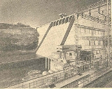
Hiwassee Dam is a hydroelectric dam on the Hiwassee River
in Cherokee County
, in the U.S. state of North Carolina
. It is one of three dams on the river owned and operated by the Tennessee Valley Authority
, which built the dam in the late 1930s to bring flood control and electricity to the region. The dam impounds the Hiwassee Lake of 6000 acres (2,428.1 ha), and its tailwaters are part of Apalachia Lake. At 307 feet (93.6 m), Hiwassee Dam is the third highest dam in the TVA system, behind only Fontana
and Watauga
.
Hiwassee Dam is named after the Hiwassee River. The river's name is derived from the Cherokee
word for savanna
, or large meadow, and had been applied to two of the tribe's villages along the river in the 18th century.
through Western North Carolina, where it proceeds to slice a scenic valley through the southern Appalachian Mountains
en route to its mouth along Chickamauga Lake
in Tennessee
. Hiwassee Dam is located nearly 76 miles (122.3 km) above the river's mouth, at the downstream end of a large bend in the river known as Fowler Bend. The dam is 10 miles (16.1 km) upstream from Apalachia Dam
(which is near the Tennessee-North Carolina state line) and 45 miles (72.4 km) downstream from Chatuge Dam
. Hiwassee Dam and its reservoir are surrounded by the Nantahala National Forest
.
Hiwassee Village, a small community that developed alongside the dam and reservoir, is located immediately south of Hiwassee Dam. North Carolina State Highway 1314 (Hiwassee Dam Access Road) crosses the top of the dam.
, and has 180 miles (289.7 km) of shoreline and 205590 acre.ft of flood storage. The reservoir's operating level varies by roughly 38 feet (11.6 m) in a typical year.
 The hydroelectric potential of the Hiwassee River has been recognized since the early 1900s. The cities of Andrews
and Murphy had already established minor dams with generating capacities along the river when major power companies began planning large-scale hydro projects in the valley in the 1920s. The Carolina-Tennessee Power Company (later reorganized as the Southern States Power Company) purchased 10000 acres (4,046.9 ha) of land and flowage rights along the river in 1924 in hopes of building a large dam just above the present dam site, but the project never materialized. The Tennessee Valley Authority, created as a New Deal
measure in 1933, was given oversight of flood control operations in the Tennessee River watershed, which included the Hiwassee. One of TVA's first initiatives was to control flooding on the Hiwassee River, the waters of which were a major contributor to flooding in Chattanooga
. Congress authorized the construction of Hiwassee Dam in 1935, and work began the following year. Southern States Power agreed to sell its Hiwassee tract to TVA, although the two entities bickered over the land's value in federal court until 1944, when TVA agreed to a final price of $250,000.
 The construction of Hiwassee Dam and its reservoir required the purchase of 24102 acres (9,753.7 ha) (including the 10000 acres (4,046.9 ha) purchased from Southern States Power), 3836 acres (1,552.4 ha) of which had to be cleared. 261 families, 462 graves, and 25 miles (40.2 km) of roads had to be relocated. Eight new bridges were constructed, and a Southern Railway trestle required modification. Several changes were necessary to protect the city of Murphy's riverfront, mainly at its main bridge and filtering plant.
Hiwassee Dam's height required a large mass of concrete which engineers feared would trap heat during its setting, making the dam more vulnerable to cracks. To help heat escape, the dam's concrete sections were divided into blocks no more than 50 feet (15.2 m) in length. The blocks' joints were formed with shear keys, and pipes were installed to allow future grouting should it become necessary. Several practices were employed to avoid trapping heat in the setting of the concrete, including the use of low-heat cement.
Hiwassee Dam's gates were closed on February 8, 1940, although minor construction work continued until later that same year. The first generator went online May 21, 1940. The dam's final price tag was just over $24 million. Shortly after the project's completion, TVA transferred 17000 acres (6,879.7 ha) of its Hiwassee reservation to the U.S. Forest Service for inclusion in the Nantahala National Forest.
Hiwassee River
The Hiwassee River has its headwaters on the north slope of Rocky Mountain in Towns County in northern Georgia and flows northward into North Carolina before turning westward into Tennessee, flowing into the Tennessee River a few miles west of State Route 58 in Meigs County, Tennessee...
in Cherokee County
Cherokee County, North Carolina
- Transportation :Cherokee County is well known in North Carolina as the westernmost of the state's 100 counties. Several US and state highways serve the county, linking it with other regions of North Carolina, along with the neighboring states of Georgia and Tennessee.US 64 - the longest highway...
, in the U.S. state of North Carolina
North Carolina
North Carolina is a state located in the southeastern United States. The state borders South Carolina and Georgia to the south, Tennessee to the west and Virginia to the north. North Carolina contains 100 counties. Its capital is Raleigh, and its largest city is Charlotte...
. It is one of three dams on the river owned and operated by the Tennessee Valley Authority
Tennessee Valley Authority
The Tennessee Valley Authority is a federally owned corporation in the United States created by congressional charter in May 1933 to provide navigation, flood control, electricity generation, fertilizer manufacturing, and economic development in the Tennessee Valley, a region particularly affected...
, which built the dam in the late 1930s to bring flood control and electricity to the region. The dam impounds the Hiwassee Lake of 6000 acres (2,428.1 ha), and its tailwaters are part of Apalachia Lake. At 307 feet (93.6 m), Hiwassee Dam is the third highest dam in the TVA system, behind only Fontana
Fontana Dam
Fontana Dam is a hydroelectric dam on the Little Tennessee River in Swain and Graham counties, North Carolina, USA. The dam is operated by the Tennessee Valley Authority, which built the dam in the early 1940s to accommodate the skyrocketing electricity demands in the Tennessee Valley at the...
and Watauga
Watauga Dam
Watauga Dam is a hydroelectric and flood control dam on the Watauga River in Carter County, in the U.S. state of Tennessee. It is owned and operated by the Tennessee Valley Authority, which built the dam in the 1940s as part of efforts to control flooding in the Tennessee River watershed...
.
Hiwassee Dam is named after the Hiwassee River. The river's name is derived from the Cherokee
Cherokee language
Cherokee is an Iroquoian language spoken by the Cherokee people which uses a unique syllabary writing system. It is the only Southern Iroquoian language that remains spoken. Cherokee is a polysynthetic language.-North American etymology:...
word for savanna
Savanna
A savanna, or savannah, is a grassland ecosystem characterized by the trees being sufficiently small or widely spaced so that the canopy does not close. The open canopy allows sufficient light to reach the ground to support an unbroken herbaceous layer consisting primarily of C4 grasses.Some...
, or large meadow, and had been applied to two of the tribe's villages along the river in the 18th century.
Location
The Hiwassee River flows northwestward from its source in Towns County, GeorgiaTowns County, Georgia
Towns County is a county located in the U.S. state of Georgia. It was created on March 6, 1856. As of the 2000 census, the population was 9,319. The 2007 Census Estimate shows a population of 10,894. Its county seat is Hiawassee.-History:...
through Western North Carolina, where it proceeds to slice a scenic valley through the southern Appalachian Mountains
Appalachian Mountains
The Appalachian Mountains #Whether the stressed vowel is or ,#Whether the "ch" is pronounced as a fricative or an affricate , and#Whether the final vowel is the monophthong or the diphthong .), often called the Appalachians, are a system of mountains in eastern North America. The Appalachians...
en route to its mouth along Chickamauga Lake
Chickamauga Lake
Chickamauga Lake is a United States reservoir along the Tennessee River created when the Chickamauga Dam, as part of the Tennessee Valley Authority, was completed in 1940. The lake stretches from Watts Bar Dam at mile 529.9 to Chickamauga Dam at mile 471.0 making the lake 58.9 miles long...
in Tennessee
Tennessee
Tennessee is a U.S. state located in the Southeastern United States. It has a population of 6,346,105, making it the nation's 17th-largest state by population, and covers , making it the 36th-largest by total land area...
. Hiwassee Dam is located nearly 76 miles (122.3 km) above the river's mouth, at the downstream end of a large bend in the river known as Fowler Bend. The dam is 10 miles (16.1 km) upstream from Apalachia Dam
Apalachia Dam
Apalachia Dam is a hydroelectric dam on the Hiwassee River in Cherokee County, in the U.S. state of North Carolina. The dam is the lowermost of three dams on the river owned and operated by the Tennessee Valley Authority, which built the dam in the early 1940s to provide emergency power for...
(which is near the Tennessee-North Carolina state line) and 45 miles (72.4 km) downstream from Chatuge Dam
Chatuge Dam
Chatuge Dam is a flood control and hydroelectric dam on the Hiwassee River in Clay County, in the U.S. state of North Carolina. The dam is the uppermost of three dams on the river owned and operated by the Tennessee Valley Authority, which built the dam in the early 1940s for flood storage and to...
. Hiwassee Dam and its reservoir are surrounded by the Nantahala National Forest
Nantahala National Forest
The Nantahala National Forest, established in 1920, is a national forest located in the American state of North Carolina. The word "Nantahala" is a Cherokee word meaning "Land of the Noonday Sun." The name is appropriate as, in some spots, the sun only reaches the floors of the deep gorges of the...
.
Hiwassee Village, a small community that developed alongside the dam and reservoir, is located immediately south of Hiwassee Dam. North Carolina State Highway 1314 (Hiwassee Dam Access Road) crosses the top of the dam.
Capacity
Hiwassee Dam is a concrete gravity overflow dam 307 feet (93.6 m) high and 1376 feet (419.4 m) long, and has a generating capacity of 185,000 kilowatts. The dam's spillway is controlled by seven radial gates, which, along with four regulating conduits at the bottom of the dam, give the dam a total maximum discharge of 112000 cuft/s. Hiwassee Lake stretches along the river for approximately 22 miles (35.4 km) to the town of Murphy, North CarolinaMurphy, North Carolina
-Household Income:The median income for a household in the town was $24,952, and the median income for a family was $35,234. Males had a median income of $30,395 versus $16,908 for females. The per capita income for the town was $16,926...
, and has 180 miles (289.7 km) of shoreline and 205590 acre.ft of flood storage. The reservoir's operating level varies by roughly 38 feet (11.6 m) in a typical year.
Background and construction
Andrews, North Carolina
Andrews is a town in Cherokee County, North Carolina, United States. The population was 1,602 at the 2000 census.-Geography:Andrews is located at .According to the United States Census Bureau, the town has a total area of , all of it land.-History:...
and Murphy had already established minor dams with generating capacities along the river when major power companies began planning large-scale hydro projects in the valley in the 1920s. The Carolina-Tennessee Power Company (later reorganized as the Southern States Power Company) purchased 10000 acres (4,046.9 ha) of land and flowage rights along the river in 1924 in hopes of building a large dam just above the present dam site, but the project never materialized. The Tennessee Valley Authority, created as a New Deal
New Deal
The New Deal was a series of economic programs implemented in the United States between 1933 and 1936. They were passed by the U.S. Congress during the first term of President Franklin D. Roosevelt. The programs were Roosevelt's responses to the Great Depression, and focused on what historians call...
measure in 1933, was given oversight of flood control operations in the Tennessee River watershed, which included the Hiwassee. One of TVA's first initiatives was to control flooding on the Hiwassee River, the waters of which were a major contributor to flooding in Chattanooga
Chattanooga, Tennessee
Chattanooga is the fourth-largest city in the US state of Tennessee , with a population of 169,887. It is the seat of Hamilton County...
. Congress authorized the construction of Hiwassee Dam in 1935, and work began the following year. Southern States Power agreed to sell its Hiwassee tract to TVA, although the two entities bickered over the land's value in federal court until 1944, when TVA agreed to a final price of $250,000.
Hiwassee Dam's height required a large mass of concrete which engineers feared would trap heat during its setting, making the dam more vulnerable to cracks. To help heat escape, the dam's concrete sections were divided into blocks no more than 50 feet (15.2 m) in length. The blocks' joints were formed with shear keys, and pipes were installed to allow future grouting should it become necessary. Several practices were employed to avoid trapping heat in the setting of the concrete, including the use of low-heat cement.
Hiwassee Dam's gates were closed on February 8, 1940, although minor construction work continued until later that same year. The first generator went online May 21, 1940. The dam's final price tag was just over $24 million. Shortly after the project's completion, TVA transferred 17000 acres (6,879.7 ha) of its Hiwassee reservation to the U.S. Forest Service for inclusion in the Nantahala National Forest.
External links
- Hiwassee Reservoir — official TVA site