
Apalachia Dam
Encyclopedia
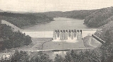
Apalachia Dam is a hydroelectric dam on the Hiwassee River
in Cherokee County
, in the U.S. state of North Carolina
. The dam is the lowermost of three dams on the river owned and operated by the Tennessee Valley Authority
, which built the dam in the early 1940s to provide emergency power for aluminum production during World War II
. While the dam is in North Carolina, an 8.3 miles (13.4 km) underground conduit carries water from the dam's reservoir to the powerhouse located 12 miles (19.3 km) downstream across the state line in Polk County, Tennessee.
Apalachia Dam is named for the crossroads community of Old Apalachia, located near the dam site in North Carolina, and the community's L&N railroad stop, known simply as Apalachia, which was further downstream on the Tennessee side of the state line.
, which flows northwestward through Northern Georgia
and Western North Carolina before emptying into Chickamauga Lake
in East Tennessee
. The dam is situated near the center of a scenic and relatively isolated valley sliced by the river as it winds its way through the southwestern fringe of the Blue Ridge Mountains
. The Unicoi Mountains rise to the north of the dam, and the Nantahala National Forest
surrounds the dam and its reservoir on all sides.
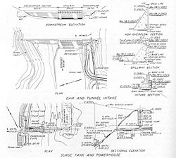
Apalachia Dam's powerhouse is located 12 miles (19.3 km) downstream from the dam at the base of a steep-walled gorge formed as the river flows between two mountain formations. The dam's 8.3 miles (13.4 km) conduit— all but 1600 feet (487.7 m) of which is underground— passes behind the cliffs on the south side of the river.
, and contains 31 miles (49.9 km) of shoreline and 1070 acres (433 ha) of water surface.
A 900 feet (274.3 m) steel penstock
connects the reservoir intake at the dam site to the 8.3 miles (13.4 km) conduit. The conduit emerges from a cliffside overlooking the dam's powerhouse, where it splits into two smaller tunnels which carry the water to a valve house. From the valve house, the water drops 200 feet (61 m) through two steel penstocks to the powerhouse turbines below.
 Private and public entities had been aware of the hydroelectric potential of the Hiwassee River since the early 1900s. The U.S. Army Corps of Engineers identified several potential dams sites, including Apalachia, in the 1920s, and by the time the Tennessee Valley Authority was formed in 1933, several companies had bought up land and flowage rights in the Hiwassee Valley. TVA took the initiative in the valley, however, with the construction of Hiwassee Dam in the late 1930s. By 1941, the outbreak of World War II in Europe brought a drastic increase in the demand for electricity— especially to support aluminum production in the Tennessee Valley— and TVA quickly put together a plan to build several new dams, including Apalachia, all of which were authorized July 16, 1941. Work began on Apalachia the following day.
 The construction of Apalachia Dam and its reservoir required the purchase of 4500 acres (1,821.1 ha) of land, most of which was in possession of three private entities— the Union Power Company, the Hiwassee-Nolichucky Power Company, and the Hiwassee River Power Company, with Union holding nearly half of the 4500 acres (18.2 km²). After the initial purchase, the Hiwassee-Nolichucky Power Company sold TVA an additional 8100 acres (3,278 ha), nearly tripling the reservation size. Land for the conduit was transferred by the U.S. Forest Service. Since most of the land was in possession of private companies, only 22 families and 2.4 miles (3.9 km) of roads had to be relocated.
The construction of the conduit was necessary to exploit the 12 miles (19.3 km) stretch of river immediately downstream from the dam site in which the river drops on average 26 feet (7.9 m) per mile. The conduit's tunnel was built using blasting and a drill jumbo, and its 235 feet (71.6 m) surge tank was excavated into the rock near the valve house.
Apalachia Dam was completed September 15, 1942, and its gates were closed February 14, 1943. The tunnel was completed April 1, 1943. The dam's first generator went online September 22, 1943, and a second went online November 17 of the same year. The total cost of the project was just over $24 million.
(Pityopsis ruthii), a major reason why the plant was placed on the Endangered Species List in 1985.
Hiwassee River
The Hiwassee River has its headwaters on the north slope of Rocky Mountain in Towns County in northern Georgia and flows northward into North Carolina before turning westward into Tennessee, flowing into the Tennessee River a few miles west of State Route 58 in Meigs County, Tennessee...
in Cherokee County
Cherokee County, North Carolina
- Transportation :Cherokee County is well known in North Carolina as the westernmost of the state's 100 counties. Several US and state highways serve the county, linking it with other regions of North Carolina, along with the neighboring states of Georgia and Tennessee.US 64 - the longest highway...
, in the U.S. state of North Carolina
North Carolina
North Carolina is a state located in the southeastern United States. The state borders South Carolina and Georgia to the south, Tennessee to the west and Virginia to the north. North Carolina contains 100 counties. Its capital is Raleigh, and its largest city is Charlotte...
. The dam is the lowermost of three dams on the river owned and operated by the Tennessee Valley Authority
Tennessee Valley Authority
The Tennessee Valley Authority is a federally owned corporation in the United States created by congressional charter in May 1933 to provide navigation, flood control, electricity generation, fertilizer manufacturing, and economic development in the Tennessee Valley, a region particularly affected...
, which built the dam in the early 1940s to provide emergency power for aluminum production during World War II
World War II
World War II, or the Second World War , was a global conflict lasting from 1939 to 1945, involving most of the world's nations—including all of the great powers—eventually forming two opposing military alliances: the Allies and the Axis...
. While the dam is in North Carolina, an 8.3 miles (13.4 km) underground conduit carries water from the dam's reservoir to the powerhouse located 12 miles (19.3 km) downstream across the state line in Polk County, Tennessee.
Apalachia Dam is named for the crossroads community of Old Apalachia, located near the dam site in North Carolina, and the community's L&N railroad stop, known simply as Apalachia, which was further downstream on the Tennessee side of the state line.
Location
Apalachia Dam is located nearly 66 miles (106.2 km) upstream from the mouth of the Hiwassee RiverHiwassee River
The Hiwassee River has its headwaters on the north slope of Rocky Mountain in Towns County in northern Georgia and flows northward into North Carolina before turning westward into Tennessee, flowing into the Tennessee River a few miles west of State Route 58 in Meigs County, Tennessee...
, which flows northwestward through Northern Georgia
Georgia (U.S. state)
Georgia is a state located in the southeastern United States. It was established in 1732, the last of the original Thirteen Colonies. The state is named after King George II of Great Britain. Georgia was the fourth state to ratify the United States Constitution, on January 2, 1788...
and Western North Carolina before emptying into Chickamauga Lake
Chickamauga Lake
Chickamauga Lake is a United States reservoir along the Tennessee River created when the Chickamauga Dam, as part of the Tennessee Valley Authority, was completed in 1940. The lake stretches from Watts Bar Dam at mile 529.9 to Chickamauga Dam at mile 471.0 making the lake 58.9 miles long...
in East Tennessee
East Tennessee
East Tennessee is a name given to approximately the eastern third of the U.S. state of Tennessee, one of the three Grand Divisions of Tennessee defined in state law. East Tennessee consists of 33 counties, 30 located within the Eastern Time Zone and three counties in the Central Time Zone, namely...
. The dam is situated near the center of a scenic and relatively isolated valley sliced by the river as it winds its way through the southwestern fringe of the Blue Ridge Mountains
Blue Ridge Mountains
The Blue Ridge Mountains are a physiographic province of the larger Appalachian Mountains range. This province consists of northern and southern physiographic regions, which divide near the Roanoke River gap. The mountain range is located in the eastern United States, starting at its southern-most...
. The Unicoi Mountains rise to the north of the dam, and the Nantahala National Forest
Nantahala National Forest
The Nantahala National Forest, established in 1920, is a national forest located in the American state of North Carolina. The word "Nantahala" is a Cherokee word meaning "Land of the Noonday Sun." The name is appropriate as, in some spots, the sun only reaches the floors of the deep gorges of the...
surrounds the dam and its reservoir on all sides.
Apalachia Dam's powerhouse is located 12 miles (19.3 km) downstream from the dam at the base of a steep-walled gorge formed as the river flows between two mountain formations. The dam's 8.3 miles (13.4 km) conduit— all but 1600 feet (487.7 m) of which is underground— passes behind the cliffs on the south side of the river.
Capacity
Apalachia Dam is a concrete gravity diversion-type dam 150 feet (45.7 m) high and 1308 feet (398.7 m) long, and has a generating capacity of 93,600 kilowatts. The dam's spillway is controlled by 10 radial gates with a combined discharge of 136000 cuft/s. Apalachia Lake stretches for 9.8 miles (15.8 km) to the base of Hiwassee DamHiwassee Dam
Hiwassee Dam is a hydroelectric dam on the Hiwassee River in Cherokee County, in the U.S. state of North Carolina. It is one of three dams on the river owned and operated by the Tennessee Valley Authority, which built the dam in the late 1930s to bring flood control and electricity to the region. ...
, and contains 31 miles (49.9 km) of shoreline and 1070 acres (433 ha) of water surface.
A 900 feet (274.3 m) steel penstock
Penstock
A penstock is a sluice or gate or intake structure that controls water flow, or an enclosed pipe that delivers water to hydraulic turbines and sewerage systems. It is a term that has been inherited from the technology of wooden watermills....
connects the reservoir intake at the dam site to the 8.3 miles (13.4 km) conduit. The conduit emerges from a cliffside overlooking the dam's powerhouse, where it splits into two smaller tunnels which carry the water to a valve house. From the valve house, the water drops 200 feet (61 m) through two steel penstocks to the powerhouse turbines below.
Background and construction
The construction of the conduit was necessary to exploit the 12 miles (19.3 km) stretch of river immediately downstream from the dam site in which the river drops on average 26 feet (7.9 m) per mile. The conduit's tunnel was built using blasting and a drill jumbo, and its 235 feet (71.6 m) surge tank was excavated into the rock near the valve house.
Apalachia Dam was completed September 15, 1942, and its gates were closed February 14, 1943. The tunnel was completed April 1, 1943. The dam's first generator went online September 22, 1943, and a second went online November 17 of the same year. The total cost of the project was just over $24 million.
Ecology
The construction of the Apalachia Dam eliminated the natural water flow on the Hiwassee River, causing the decline of Ruth's golden asterPityopsis ruthii
Pityopsis ruthii is a rare species of flowering plant in the aster family known by the common name Ruth's golden aster. It is endemic to the US state of Tennessee, where it is known only from Polk County. It is threatened by the modification of its habitat...
(Pityopsis ruthii), a major reason why the plant was placed on the Endangered Species List in 1985.
External links
- Apalachia Reservoir — official TVA site