

Hiking in Chile
Encyclopedia
Torres del Paine National Park
Torres del Paine National Park is a national park encompassing mountains, a glacier, a lake, and river-rich areas in southern Chilean Patagonia. The Cordillera del Paine is the centerpiece of the park. It lies in a transition area between the Magellanic subpolar forests and the Patagonian Steppes...
. There are approximately 2,000 km of Trails and another 1,400 under development
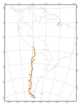
Sendero de Chile (Chilean path)
Recently a project called Sendero de Chile attempts to connect and create major trail systems from all across the Chilean territory stretching from north to south. The project was created to celebrate Chile’s 2010 bicentennial anniversary of independence from Spain. However, delays on the completion of the project have delayed the inauguration date beyond 2010.The Chilean government claims that when Sendero de Chile is completed it will be the “longest hiking route in the world” stretching 9,700 kilometers from the northern city of Arica
Arica, Chile
Arica is a commune and a port city with a population of 185,269 in the Arica Province of northern Chile's Arica and Parinacota Region, located only south of the border with Peru. The city is the capital of both the Arica Province and the Arica and Parinacota Region...
to one of South America
South America
South America is a continent situated in the Western Hemisphere, mostly in the Southern Hemisphere, with a relatively small portion in the Northern Hemisphere. The continent is also considered a subcontinent of the Americas. It is bordered on the west by the Pacific Ocean and on the north and east...
's southernmost settlement, Cape Horn
Cape Horn
Cape Horn is the southernmost headland of the Tierra del Fuego archipelago of southern Chile, and is located on the small Hornos Island...
.
Trails
.jpg)
The hiking trail system in Chile already includes over 2,000 km of paths, and after expansion of Sendero de Chile the number is expected to increase to over 3.460 km. of native forest, desert, lakes and volcanoes, numerous coastal segments, which also overlaps trails along Chile's southern glaciers.
The project Sendero de Chile will also have some kilometers of waterways where snorkeling
Snorkeling
Snorkeling is the practice of swimming on or through a body of water while equipped with a diving mask, a shaped tube called a snorkel, and usually swimfins. In cooler waters, a wetsuit may also be worn...
Scuba diving
Scuba diving
Scuba diving is a form of underwater diving in which a diver uses a scuba set to breathe underwater....
and kayaking
Kayaking
Kayaking is the use of a kayak for moving across water. Kayaking and canoeing are also known as paddling. Kayaking is distinguished from canoeing by the sitting position of the paddler and the number of blades on the paddle...
will be possible.
The Mega Trail system is classified into different sections and circuits. The main sections are:
- The Trail of the High Planes and the Driest Desert in Northern ChileNorte Grande, ChileThe Norte Grande is one of the five natural regions into which CORFO divided continental Chile in 1950. It borders Peru to the north, the Pacific Ocean to the west, the Altiplano, Bolivia and Argentina to the east, and the Copiapó River to the south, beyond which lies the Norte Chico natural...
- The Trail of the Valleys in Central ChileZona Central, ChileZona central is one of the five natural regions into which CORFO divided continental Chile in 1950. It is home to a majority of the Chilean population and includes the three largest metropolitan areas- Santiago, Valparaíso, and Concepción...
- The Trail of Lakes and Volcanoes in Southern ChileZona SurThe Zona Sur is one of the five natural regions on which CORFO divided continental Chile in 1950. Its northern border is formed by the Bío-Bío River, the limit with the Central Chile Zone. By west with the Pacific Ocean, by the east with the Andean mountains and Argentina. Its southern border is...
, AraucaniaAraucanía RegionThe IX Araucanía Region is one of Chile's 15 first order administrative divisions and comprises two provinces: Malleco in the north and Cautín in the south....
and lake area) - The Trail of Patagonia in Patagonia and the Southern GlaciersZona AustralThe Zona Austral is one of the five natural regions into which CORFO divided continental Chile in 1950 corresponding to the Chilean portion of Patagonia. It is surrounded by the Southern Zone and the Chacao Channel to the north, the Pacific Ocean and Drake's Passage to the south and west, and the...
(from Patagonia to Magallanes) - The Trail of the Islands (Chiloe and Easter IslandEaster IslandEaster Island is a Polynesian island in the southeastern Pacific Ocean, at the southeasternmost point of the Polynesian triangle. A special territory of Chile that was annexed in 1888, Easter Island is famous for its 887 extant monumental statues, called moai, created by the early Rapanui people...
)
See also
- Tourism in ChileTourism in ChileTourism in 'Chile has experienced sustained growth over the last decades. Chile received about 1.25 million foreign visitors in 2006, up to 2.50 million in 2007...
- Regions of Chile
- Geography of ChileGeography of ChileImage:Chilenav.gif|thumb|417px|left|Click over the map to obtain a topographic map of the region and its toponymyrect 23 14 119 35 rect 23 35 119 44 rect 23 44 119 54 rect 23 54 119 65 rect 23 65 119 75 rect 23 75 119 85...