

Highways in Slovenia
Encyclopedia
Limited-access road
A limited-access road known by various terms worldwide, including limited-access highway, dual-carriageway and expressway, is a highway or arterial road for high-speed traffic which has many or most characteristics of a controlled-access highway , including limited or no access to adjacent...
. Motorways are dual carriageways with a speed limit of 130 kilometres per hour (80.8 mph). They have white-on-green road signs as in Italy, Croatia and other countries nearby. Expressways are secondary roads, also dual carriageways, but without an emergency lane. They have a speed limit of 110 kilometres per hour (68.4 mph) and have white-on-blue road signs.
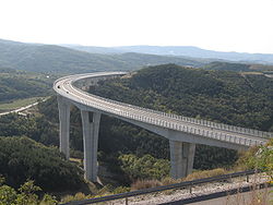
The first highway in Slovenia, the A1 motorway
A1 motorway (Slovenia)
The A1 motorway is 236,1 km long, connecting Šentilj and Koper/Capodistria . It passes several important Slovenian cities, including Maribor, Celje and Ljubljana all the way to the Slovenian Littoral and Koper, with its important port.Construction began in 1970 and the first section was...
, was opened in 1972, connecting Vrhnika
Vrhnika
Vrhnika is a town and a municipality in Slovenia. It is situated on the Ljubljanica River, 21 km from Ljubljana along the A1 motorway.-History:...
and Postojna
Postojna
Postojna is a town and a municipality in the traditional region of Inner Carniola, from Trieste, in southwestern Slovenia. Population 14,581 .-History:...
. Constructed under the reformist minded Communist government of Stane Kavčič, their development plan envisioned a modern highway network spanning Slovenia and connecting the republic to Italy and Austria. After the reformist fraction of the Communist Party of Slovenia was deposed in the early 1970s, the expansion of the Slovenian highway network came to a halt.
In 1994, the new country started the National Motorway Construction Programme (NPIA), effectively re-using the old Communist plans. Since then, 528 km of motorways, expressways and similar roads have been completed, easing automotive transport across the country and providing a much better road service between eastern and western Europe. This has encouraged the development of transportation and export industries.
Highways and accessory structures in Slovenia are managed by the state-owned Motorway Company in the Republic of Slovenia established in 1994. , DARS is managing and maintaining 533.3 km of motorways, 73.3 km of expressways, 161 km of access roads and 27 km of rest area
Rest area
A rest area, travel plaza, rest stop, or service area is a public facility, located next to a large thoroughfare such as a highway, expressway, or freeway at which drivers and passengers can rest, eat, or refuel without exiting on to secondary roads...
s. Since the 1 June 2008, highway users in Slovenia are required to buy a vignette
Vignette (road tax)
A road tax vignette is a form of tax on vehicles, used in several non-English speaking European countries. The term is of French origin, and is now used throughout Central Europe....
. 7-day, 1-month and annual passes are available.
According to the Slovenian Motorway Company Act valid since December 2010, the construction and building of highways in Slovenia is carried out and financed by private companies, primarily the Motorway Company in the Republic of Slovenia (planned to become at least partially private), while the strategic planning and the acquisition of land for their course is carried out and financed by the state. The highways are owned by DARS.
Motorways
- A1 (Slovenika)A1 motorway (Slovenia)The A1 motorway is 236,1 km long, connecting Šentilj and Koper/Capodistria . It passes several important Slovenian cities, including Maribor, Celje and Ljubljana all the way to the Slovenian Littoral and Koper, with its important port.Construction began in 1970 and the first section was...
- Route: ŠentiljŠentiljŠentilj is a municipality in Slovenia. The seat of the municipality is the town of Šentilj v Slovenskih goricah . This town was an Austria-Slovenia border crossing checkpoint until December 21, 2007, when all immigration and customs checks ended after Slovenia joined the Schengen Area...
(AustriaAustriaAustria , officially the Republic of Austria , is a landlocked country of roughly 8.4 million people in Central Europe. It is bordered by the Czech Republic and Germany to the north, Slovakia and Hungary to the east, Slovenia and Italy to the south, and Switzerland and Liechtenstein to the...
n border) - MariborMariborMaribor is the second largest city in Slovenia with 157,947 inhabitants . Maribor is also the largest and the capital city of Slovenian region Lower Styria and the seat of the Municipality of Maribor....
(H2) - CeljeCeljeCelje is a typical Central European town and the third largest town in Slovenia. It is a regional center of Lower Styria and the administrative seat of the Urban Municipality of Celje . The town of Celje is located under Upper Celje Castle at the confluence of the Savinja, Ložnica, and Voglajna...
- LjubljanaLjubljanaLjubljana is the capital of Slovenia and its largest city. It is the centre of the City Municipality of Ljubljana. It is located in the centre of the country in the Ljubljana Basin, and is a mid-sized city of some 270,000 inhabitants...
(A2, H3) - PostojnaPostojnaPostojna is a town and a municipality in the traditional region of Inner Carniola, from Trieste, in southwestern Slovenia. Population 14,581 .-History:...
- RazdrtoRazdrto, PostojnaRazdrto is a village at the southern slopes of Mount Nanos in the Postojna Municipality in the Inner Carniola region of Slovenia. It lies at a major interchange on the A1 motorway connecting Ljubljana to the Slovenian Littoral....
(H4) - DivačaDivacaDivača is a small town and municipality in the Littoral region of Slovenia, a few kilometres from the Italian border.The Parish Church in the settlement is dedicated to Saint Anthony the Hermit and belongs to the Diocese of Koper....
(A3) - Koper (H5) - Length: 245.3 km
- Route: Šentilj
- A2 (Ilirika)A2 motorway (Slovenia)The A2 motorway is a motorway in Slovenia, around 175 km long, connecting Karavanke Tunnel via the capital city Ljubljana to Obrežje . It connects several larger Slovenian cities, including Kranj, Ljubljana and Novo Mesto, and is part of the Pan-European corridor X.The motorway was completed...
- Route: Karavanke Tunnel (AustriaAustriaAustria , officially the Republic of Austria , is a landlocked country of roughly 8.4 million people in Central Europe. It is bordered by the Czech Republic and Germany to the north, Slovakia and Hungary to the east, Slovenia and Italy to the south, and Switzerland and Liechtenstein to the...
n border) - Jesenice - KranjKranj' is the third largest municipality and fourth largest city in Slovenia, with a population of 54,500 . It is located approximately 20 km north-west of Ljubljana...
- LjubljanaLjubljanaLjubljana is the capital of Slovenia and its largest city. It is the centre of the City Municipality of Ljubljana. It is located in the centre of the country in the Ljubljana Basin, and is a mid-sized city of some 270,000 inhabitants...
(A1, H3) - Novo MestoNovo MestoNovo Mesto is a city and municipality in southeastern Slovenia, close to the border with Croatia. The town is traditionally considered the economic and cultural centre of the historic Lower Carniola region.-Geography:...
- BrežiceBrežiceBrežice is a city and municipality in eastern Slovenia in the Lower Sava Valley, near the Croatian border. The area was traditionally divided between Lower Styria and Lower Carniola...
- ObrežjeObrežjeObrežje is a settlement in the Brežice municipality in eastern Slovenia, close to the border with Croatia. A major motorway border crossing is located here. Obrežje is the end/start of Slovenia's A2 motorway. It connects to Croatia's A3 Motorway. Both motorways form part of the European route...
(CroatiaCroatiaCroatia , officially the Republic of Croatia , is a unitary democratic parliamentary republic in Europe at the crossroads of the Mitteleuropa, the Balkans, and the Mediterranean. Its capital and largest city is Zagreb. The country is divided into 20 counties and the city of Zagreb. Croatia covers ...
n border) - Length: 175.5 km
- Route: Karavanke Tunnel (Austria
- A3 (Kras Highway)
- Route: Gabrk/DivačaDivacaDivača is a small town and municipality in the Littoral region of Slovenia, a few kilometres from the Italian border.The Parish Church in the settlement is dedicated to Saint Anthony the Hermit and belongs to the Diocese of Koper....
(A1) - SežanaSežanaSežana is a town and a municipality in the Slovenian Littoral region of Slovenia, near the border with Italy. According to the census of 2008, it has a population of 12,470, of which around 5,332 live in the town of Sežana and the rest in the neighbouring rural areas.Sežana is located about on the...
- Fernetiči (Italian borderItalyItaly , officially the Italian Republic languages]] under the European Charter for Regional or Minority Languages. In each of these, Italy's official name is as follows:;;;;;;;;), is a unitary parliamentary republic in South-Central Europe. To the north it borders France, Switzerland, Austria and...
) - Length: 11.3 km
- Route: Gabrk/Divača
- A4 (Podravski krak)A4 motorway (Slovenia)The A4 motorway is a motorway in Slovenia, planned to be 33.7 km long, connecting Maribor and Gruškovje . It also connects the two principal cities of the Podravska region of Slovenia, Maribor and Ptuj...
(colloquially also the Pyhrn Highway)- Route: SlivnicaHoce-SlivnicaHoče-Slivnica is a municipality to the south of Maribor in northeastern Slovenia.Its administrative centre is in Spodnje Hoče. Traditionally the area was part of Lower Styria. It is now included in the Drava statistical region. The municipality extends from the flatlads on the right bank of the...
/MariborMariborMaribor is the second largest city in Slovenia with 157,947 inhabitants . Maribor is also the largest and the capital city of Slovenian region Lower Styria and the seat of the Municipality of Maribor....
(R2-430, H2) - HajdinaHajdinaHajdina is a small municipality on the right bank of the river Drava near Ptuj in northeastern Slovenia. Its administrative centre is the village of Zgornja Hajdina. Traditionally the area was part of the Lower Styria region. The municipality is now included in the Podravje statistical region...
/PtujPtujPtuj is a city and one of 11 urban municipalities in Slovenia. Traditionally the area was part of the Lower Styria region. The municipality is now included in the Podravje statistical region...
- Gruškovje (CroatiaCroatiaCroatia , officially the Republic of Croatia , is a unitary democratic parliamentary republic in Europe at the crossroads of the Mitteleuropa, the Balkans, and the Mediterranean. Its capital and largest city is Zagreb. The country is divided into 20 counties and the city of Zagreb. Croatia covers ...
n border) - the section from Draženci to Gruškovje (Croatian border) has yet to be built
- Length: 20.4 km
- Route: Slivnica
- A5 (Pomurski krak)A5 motorway (Slovenia)The A5 motorway is 85,5 km long. It begins at the Dragučova interchange on the A1 motorway north of Maribor and ends at the Hungarian border at Pince, continuing on in Hungary as the M70 motorway...
- Route: MariborMariborMaribor is the second largest city in Slovenia with 157,947 inhabitants . Maribor is also the largest and the capital city of Slovenian region Lower Styria and the seat of the Municipality of Maribor....
(A1) - Murska SobotaMurska SobotaMurska Sobota is a city in northeastern Slovenia. It is located in the eponymous municipality near the Mura River in the region of Prekmurje and is the regional capital.-Name:...
- LendavaLendavaLendava is a town and a municipality in Slovenia in the region of Prekmurje. It is close to the border crossing with Hungary at Dolga vas-Rédics, and Hungarian is one of the official languages of the municipality, along with Slovene...
- PincePincePince is a settlement to the southeast of Lendava in the Prekmurje region of Slovenia. It lies close to the extreme eastern point of Slovenia, right on the border with Hungary.-External links:*...
(Hungarian borderHungaryHungary , officially the Republic of Hungary , is a landlocked country in Central Europe. It is situated in the Carpathian Basin and is bordered by Slovakia to the north, Ukraine and Romania to the east, Serbia and Croatia to the south, Slovenia to the southwest and Austria to the west. The...
) - Length: 82.3 km
- Route: Maribor
Expressways
- H1
- was discontinued after the completion of A2 motorway in 2010
- H2 - the expressway through MariborMariborMaribor is the second largest city in Slovenia with 157,947 inhabitants . Maribor is also the largest and the capital city of Slovenian region Lower Styria and the seat of the Municipality of Maribor....
- Route: Tržaška c. (R2-430) - TeznoTeznoTezno is a suburb of the city of Maribor in Slovenia.During World War II, an anti-tank trench was dug in Tezno, around one kilometer in length and 3 to 4 meters wide. At the end of the war in 1945, in the events now collectively referred to as the Bleiburg massacre, the Yugoslav Partisans buried...
- PesnicaPesnicaPesnica is a municipality in northeastern Slovenia and administrative unit Upravna enota Pesnica. The center of municipality is a suburbia near Maribor, Pesnica pri Mariboru. It lies at the western end of the Slovenske Gorice hills at the upper valley of the eponymous river. The area was part of...
(A1) - Length: 7.2 km
- Route: Tržaška c. (R2-430) - Tezno
- H3 - northern section of Ljubljana bypassLjubljana bypassThe Ljubljana bypass is a motorway ringroad around the city of Ljubljana. The bypass forms the main hub of the Slovenian motorway network and connects to the A1 and A2 motorways. The bypass itself is signed as the A1 on the southern and eastern parts, the A2 on the western and southern parts, while...
- Route: ZadobrovaZadobrova, Ljubljana-Loacation:Zadobrova is a part of Ljubljana, the capital of Slovenia. It is a suburb that used to be a separate village until recently.-Subdivisions:Zadobrova is part of the Polje District...
- Koseze - Length: 8.1 km
- Route: Zadobrova
- H4 (Vipava Expressway)
- Route: RazdrtoRazdrto, PostojnaRazdrto is a village at the southern slopes of Mount Nanos in the Postojna Municipality in the Inner Carniola region of Slovenia. It lies at a major interchange on the A1 motorway connecting Ljubljana to the Slovenian Littoral....
(A1) - AjdovščinaAjdovšcinaAjdovščina is a small town and a municipality with the same name and a population of 7000 , located in the Vipava Valley , Slovenia....
- Nova GoricaNova GoricaNova Gorica ; 21,082 ; 31,000 ) is a town and a municipality in western Slovenia, on the border with Italy...
- VrtojbaVrtojbaVrtojba is a settlement in the Šempeter-Vrtojba municipality in the Slovene Littoral region of Slovenia. A border crossing into Italy is located here...
(Italian borderItalyItaly , officially the Italian Republic languages]] under the European Charter for Regional or Minority Languages. In each of these, Italy's official name is as follows:;;;;;;;;), is a unitary parliamentary republic in South-Central Europe. To the north it borders France, Switzerland, Austria and...
) - Length: 40,9km
- Route: Razdrto
- H5
- Route: Spodnje ŠkofijeSpodnje ŠkofijeSpodnje Škofije is a settlement in the Koper Municipality in the Littoral region of Slovenia.-Overview:Until the dissolution of the Free Territory of Trieste in 1954, it was part of the municipality of Muggia, now in Italy...
(Italian borderItalyItaly , officially the Italian Republic languages]] under the European Charter for Regional or Minority Languages. In each of these, Italy's official name is as follows:;;;;;;;;), is a unitary parliamentary republic in South-Central Europe. To the north it borders France, Switzerland, Austria and...
) - Srmin (A1) - Koper - DragonjaDragonjaDragonja is a river in Slovenia, in the northern part of the Istrian peninsula. It is the third longest river in Istria, after Raša and Mirna.The river is in length and flows into the Gulf of Piran....
(CroatiaCroatiaCroatia , officially the Republic of Croatia , is a unitary democratic parliamentary republic in Europe at the crossroads of the Mitteleuropa, the Balkans, and the Mediterranean. Its capital and largest city is Zagreb. The country is divided into 20 counties and the city of Zagreb. Croatia covers ...
n border) - section Koper - Dragonja is planned
- Length: 8.8 km
- Route: Spodnje Škofije
- H6 (coast road)
- Route: Koper - IzolaIzolaIzola is an old fishing city and a municipality in southwestern Slovenia on the Adriatic coast of the Istrian peninsula. Its name originates from the Italian Isola, which means island.- History :...
- Lucija - section Koper - Izola is under construction and Jagodje - Lucija is planned
- Length: 4.5 km
- Route: Koper - Izola
- H7
- Route: Dolga vas interchange - Dolga vas border crossing (Hungarian borderHungaryHungary , officially the Republic of Hungary , is a landlocked country in Central Europe. It is situated in the Carpathian Basin and is bordered by Slovakia to the north, Ukraine and Romania to the east, Serbia and Croatia to the south, Slovenia to the southwest and Austria to the west. The...
) - Length: 3.5 km
- Route: Dolga vas interchange - Dolga vas border crossing (Hungarian border
Controversy
The apparent slower tempo of construction of Slovenian highways in the direction north-south, in comparison to the direction east-west, has been the source of some speculation in CroatiaCroatia
Croatia , officially the Republic of Croatia , is a unitary democratic parliamentary republic in Europe at the crossroads of the Mitteleuropa, the Balkans, and the Mediterranean. Its capital and largest city is Zagreb. The country is divided into 20 counties and the city of Zagreb. Croatia covers ...
n media, because Croatia had built many highways northwards (toward Slovenia), yet the other side has not yet followed suit, thereby impacting the connections of Croatia with western Europe through Slovenia.
This is despite some agreements on the official government level.
In particular this refers to the roads between Trieste
Trieste
Trieste is a city and seaport in northeastern Italy. It is situated towards the end of a narrow strip of land lying between the Adriatic Sea and Italy's border with Slovenia, which lies almost immediately south and east of the city...
/Koper and Istria
Istria
Istria , formerly Histria , is the largest peninsula in the Adriatic Sea. The peninsula is located at the head of the Adriatic between the Gulf of Trieste and the Bay of Kvarner...
/Rijeka
Rijeka
Rijeka is the principal seaport and the third largest city in Croatia . It is located on Kvarner Bay, an inlet of the Adriatic Sea and has a population of 128,735 inhabitants...
, the route Ljubljana-Zagreb
Zagreb
Zagreb is the capital and the largest city of the Republic of Croatia. It is in the northwest of the country, along the Sava river, at the southern slopes of the Medvednica mountain. Zagreb lies at an elevation of approximately above sea level. According to the last official census, Zagreb's city...
, as well as Maribor-Zagreb.
The officials from the Slovenian Ministry of Transportation have rejected claims that their road construction is lagging behind Croatia, saying that they are an exaggeration, as their overall kilometers of highway per person ratio and other statistics are favorable.