

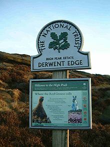
High Peak Estate
Encyclopedia
Pennines
The Pennines are a low-rising mountain range, separating the North West of England from Yorkshire and the North East.Often described as the "backbone of England", they form a more-or-less continuous range stretching from the Peak District in Derbyshire, around the northern and eastern edges of...
moorland
Moorland
Moorland or moor is a type of habitat, in the temperate grasslands, savannas, and shrublands biome, found in upland areas, characterised by low-growing vegetation on acidic soils and heavy fog...
in the ownership of the National Trust
National Trust for Places of Historic Interest or Natural Beauty
The National Trust for Places of Historic Interest or Natural Beauty, usually known as the National Trust, is a conservation organisation in England, Wales and Northern Ireland...
in the Dark Peak area of Derbyshire
Derbyshire
Derbyshire is a county in the East Midlands of England. A substantial portion of the Peak District National Park lies within Derbyshire. The northern part of Derbyshire overlaps with the Pennines, a famous chain of hills and mountains. The county contains within its boundary of approx...
, England
England
England is a country that is part of the United Kingdom. It shares land borders with Scotland to the north and Wales to the west; the Irish Sea is to the north west, the Celtic Sea to the south west, with the North Sea to the east and the English Channel to the south separating it from continental...
.
The National Trust High Peak
High Peak
High Peak is a non-metropolitan district and borough of the non-metropolitan county of Derbyshire, England. Administered from Buxton, it is mostly composed of high moorland plateau in the Dark Peak of the Peak District....
Estate is to be known as the 'Dark Peak
Dark Peak
The Dark Peak is the higher, wilder northern part of the Peak District in England.It gets its name because , the underlying limestone is covered by a cap of Millstone Grit which means that in winter the soil is almost always saturated with water...
Area' from summer 2010 which is now part of the Peak District
Peak District
The Peak District is an upland area in central and northern England, lying mainly in northern Derbyshire, but also covering parts of Cheshire, Greater Manchester, Staffordshire, and South and West Yorkshire....
Estate. The Peak District
Peak District
The Peak District is an upland area in central and northern England, lying mainly in northern Derbyshire, but also covering parts of Cheshire, Greater Manchester, Staffordshire, and South and West Yorkshire....
Estate also includes the White Peak
White Peak
The White Peak is the lower, southern part of the Peak District in England. In contrast to the Dark Peak, the underlying limestone is not capped by impervious millstone grit, so caves and dry river valleys are common features of the area...
Area (formerly South Peak) and the Longshaw
Longshaw
Longshaw is a small residential and agricultural area within Billinge Higher End at the western boundary of the Metropolitan Borough of Wigan, in Greater Manchester, England. It is situated at the northern foot of Billinge Hill on the B5206 road...
Estate near Sheffield
Sheffield
Sheffield is a city and metropolitan borough of South Yorkshire, England. Its name derives from the River Sheaf, which runs through the city. Historically a part of the West Riding of Yorkshire, and with some of its southern suburbs annexed from Derbyshire, the city has grown from its largely...
and includes a number of sites of interest including:
- Alport CastlesAlport CastlesThe Alport Castles are a landslip feature in the Peak District of Derbyshire, said to be the largest landslide in the United Kingdom. They lie north of the Snake Pass and north west of Ladybower Reservoir...
(a spectacular natural landslipLandslideA landslide or landslip is a geological phenomenon which includes a wide range of ground movement, such as rockfalls, deep failure of slopes and shallow debris flows, which can occur in offshore, coastal and onshore environments...
) - BleaklowBleaklowBleaklow is a high, largely peat covered, gritstone moorland, just north of Kinder Scout, across the Snake Pass , in the Derbyshire High Peak near the town of Glossop...
(a massive expanse of wild, windswept moorland) - Derwent EdgeDerwent EdgeDerwent Edge is a Millstone Grit escarpment that lies above the Upper Derwent Valley in the Peak District National Park in the English county of Derbyshire...
- Kinder ScoutKinder ScoutKinder Scout is a moorland plateau in the Dark Peak of the Derbyshire Peak District in England. Part of the moor, at 636 m above sea level, is the highest point in the Peak District, the highest point in Derbyshire, and the highest point in the East Midlands. It is accessible from the villages of...
(the moorlandMoorlandMoorland or moor is a type of habitat, in the temperate grasslands, savannas, and shrublands biome, found in upland areas, characterised by low-growing vegetation on acidic soils and heavy fog...
plateauPlateauIn geology and earth science, a plateau , also called a high plain or tableland, is an area of highland, usually consisting of relatively flat terrain. A highly eroded plateau is called a dissected plateau...
that was the site of 1932's Mass TrespassMass trespass of Kinder Scoutthumb|left|North flank of Kinder ScoutThe mass trespass of Kinder Scout was a notable act of willful trespass by ramblers. It was undertaken at Kinder Scout, Derbyshire, in the Peak District of England, on 24 April 1932, to highlight that walkers in England and Wales were denied access to areas of...
) - Kinder Scout is the highest point in the Peak DistrictPeak DistrictThe Peak District is an upland area in central and northern England, lying mainly in northern Derbyshire, but also covering parts of Cheshire, Greater Manchester, Staffordshire, and South and West Yorkshire....
. - Mam TorMam TorMam Tor is a hill near Castleton in the High Peak of Derbyshire, England. Its name literally translates as Heights of the Mother and it is also known as the Shivering Mountain on account of the instability of its lower shale layers...
- Odin MineOdin MineOdin Mine is a disused lead mine in the Peak District National Park, situated at grid reference . It lies on a site of 25 hectares near the village of Castleton, England. It is the oldest documented mine in Derbyshire and is thought to be one of the oldest lead mines in England...
(one of the oldest lead mines in the county) - Snake PassSnake PassThe Snake Pass is the name given to the remote, higher reaches of the A57 road where it crosses the Peak District between Manchester and Sheffield in the north of England...
- to the east of the estate - Winnats PassWinnats PassWinnats Pass is in the High Peak area of the English county of Derbyshire. It lies to the west of the village of Castleton, in the National Trust's High Peak Estate. The road winds through a cleft, surrounded by towering limestone pinnacles...
- to the north of CastletonCastletonCastleton is a honeypot village in the Derbyshire Peak District, in England. The village lies at the western end of the Hope Valley on the Peakshole Water, a tributary of the River Noe. The village is situated between the areas known as the Dark Peak and the White Peak...