
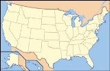
Gulf Islands National Seashore
Encyclopedia
Gulf Islands National Seashore offers recreation opportunities and preserves natural and historic resources along the Gulf of Mexico
barrier island
s of Florida
and Mississippi
. The protected regions include mainland areas and parts of 7 islands. Some islands along the Alabama
coast were originally considered for inclusion, but as of 2009, none is part of the National Seashore.
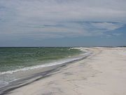
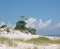 of the seashore features offshore barrier islands with sparkling white quartz sand beaches (along miles of undeveloped land), historic fortifications, and nature trails. Mainland features near Pensacola, Florida
, include the Naval Live Oaks Reservation
, beaches, and military forts. All Florida areas are accessible by automobile.
The Mississippi District of the seashore features natural beaches, historic sites, wildlife sanctuaries, islands accessible only by boat, bayous, nature trails, picnic areas, and campgrounds. The Davis Bayou Area is the only portion of the National Seashore in Mississippi that is accessible by automobile. Petit Bois, Horn, East Ship, West Ship, and Cat Islands are accessible only by boat. The 4080 acres (16.5 km²) Gulf Islands Wilderness offers special protection, within the seashore, to parts of Petit Bois Island and Horn Island, Mississippi.
Considerable damage to public infrastructure occurred as a result of the 2004
and 2005 Atlantic hurricane season
s. In subsequent years, infrastructure was fully repaired. All roadways, parking areas, campgrounds, and visitor centers have been repaired and are fully operational. A few trails and associated boardwalks and dune crossovers were still under repair as of late 2010, especially near the Fort Pickens campground.
 Principal islands in the seashore (from east to west):
. The wilderness area was designated on November 10, 1978.
Florida Visitor Centers
Mississippi Visitor Centers
In Florida, the Fort Pickens Campground is a developed campground providing water and electrical hookups for recreational vehicles and tents. Roads are paved throughout the campground, as well as each campsite. The environment is characterized by sand scrub oak
s, small brackish ponds, and a remnant pine forest on a barrier island between Pensacola Bay and the Gulf of Mexico. Central restrooms and showers are available. A campground store reopened in late 2010 (after being closed following storm impacts from Hurricanes Ivan and Dennis in 2004 and 2005, respectively). There are no sewer hookups at the campsites, however a dump station is available. Reservations can be made through the "ReserveAmerica" website from March through October. From November through February, sites are available on a first come/first serve basis. The campground is located approximately 1.5 miles (2 km) from Fort Pickens itself.
In Mississippi, the Davis Bayou Campground is a developed campground providing water and electrical hookups for recreational vehicles and tents. Roads are paved throughout the campground, as well as each campsite. The environment is characterized by an oak and pine forest adjacent to a brackish bayou connected to Mississippi Sound. Central restrooms and showers are available. There are no sewer hookups at the campsites, however a dump station is available. Campsites are available only on a first come/first serve basis. The campground is located at the end of roadway leading through the Davis Bayou Area.
Primitive camping is permitted on several of the barrier islands. Boating or hiking in is required. Such camping is allowed on Perdido Key, Florida (east of Johnson Beach), and on government-owned properties on Petit Bois, Horn, East Ship, and Cat Islands in Mississippi. With several islands in Mississippi designated as "wilderness areas", an unusual opportunity exists along the northern Gulf Coast for a wilderness experience.
, beginning 20 April 2010, released masses of oil and tar which began washing ashore, in varying amounts, along the Gulf Islands National Seashore on 1 June 2010. However, on 23 June 2010, wave after wave of oil pools and globs began covering the beaches on Santa Rosa Island
,
resulting in a fishing and swimming ban, which expanded the first major impacts of the oil-spill disaster to every large island in the group.
Entrance fees are charged at the entrance to the Fort Pickens area at Pensacola Beach, as well as the Johnson Beach Area at Perdido Key in Florida. The typical automobile entrance fee is USD$8, good for seven days. Annual passes can be purchased for USD$25.
The various forms of the "America the Beautiful - National Parks and Federal Recreational Lands Pass" are accepted.
There are no entrance fees charged in any other areas of the National Seashore.
Gulf of Mexico
The Gulf of Mexico is a partially landlocked ocean basin largely surrounded by the North American continent and the island of Cuba. It is bounded on the northeast, north and northwest by the Gulf Coast of the United States, on the southwest and south by Mexico, and on the southeast by Cuba. In...
barrier island
Barrier island
Barrier islands, a coastal landform and a type of barrier system, are relatively narrow strips of sand that parallel the mainland coast. They usually occur in chains, consisting of anything from a few islands to more than a dozen...
s of Florida
Florida
Florida is a state in the southeastern United States, located on the nation's Atlantic and Gulf coasts. It is bordered to the west by the Gulf of Mexico, to the north by Alabama and Georgia and to the east by the Atlantic Ocean. With a population of 18,801,310 as measured by the 2010 census, it...
and Mississippi
Mississippi
Mississippi is a U.S. state located in the Southern United States. Jackson is the state capital and largest city. The name of the state derives from the Mississippi River, which flows along its western boundary, whose name comes from the Ojibwe word misi-ziibi...
. The protected regions include mainland areas and parts of 7 islands. Some islands along the Alabama
Alabama
Alabama is a state located in the southeastern region of the United States. It is bordered by Tennessee to the north, Georgia to the east, Florida and the Gulf of Mexico to the south, and Mississippi to the west. Alabama ranks 30th in total land area and ranks second in the size of its inland...
coast were originally considered for inclusion, but as of 2009, none is part of the National Seashore.
Pensacola, Florida
Pensacola is the westernmost city in the Florida Panhandle and the county seat of Escambia County, Florida, United States of America. As of the 2000 census, the city had a total population of 56,255 and as of 2009, the estimated population was 53,752...
, include the Naval Live Oaks Reservation
Naval Live Oaks Reservation
The Naval Live Oaks Reservation is part of the Gulf Islands National Seashore, and is near Gulf Breeze, Florida. The Reservation was included in the Seashore's establishment on January 8, 1971, and added to the U.S. National Register of Historic Places on September 28, 1998.-History:The U.S...
, beaches, and military forts. All Florida areas are accessible by automobile.
The Mississippi District of the seashore features natural beaches, historic sites, wildlife sanctuaries, islands accessible only by boat, bayous, nature trails, picnic areas, and campgrounds. The Davis Bayou Area is the only portion of the National Seashore in Mississippi that is accessible by automobile. Petit Bois, Horn, East Ship, West Ship, and Cat Islands are accessible only by boat. The 4080 acres (16.5 km²) Gulf Islands Wilderness offers special protection, within the seashore, to parts of Petit Bois Island and Horn Island, Mississippi.
Considerable damage to public infrastructure occurred as a result of the 2004
2004 Atlantic hurricane season
The 2004 Atlantic hurricane season officially began on June 1, 2004, and lasted until November 30, 2004. These dates conventionally delimit the period of each year when most tropical cyclones form in the Atlantic basin...
and 2005 Atlantic hurricane season
2005 Atlantic hurricane season
The 2005 Atlantic hurricane season was the most active Atlantic hurricane season in recorded history, repeatedly shattering numerous records. The impact of the season was widespread and ruinous with an estimated 3,913 deaths and record damage of about $159.2 billion...
s. In subsequent years, infrastructure was fully repaired. All roadways, parking areas, campgrounds, and visitor centers have been repaired and are fully operational. A few trails and associated boardwalks and dune crossovers were still under repair as of late 2010, especially near the Fort Pickens campground.
Islands
- Santa Rosa IslandSanta Rosa Island, FloridaSanta Rosa Island[p] is a 40-mile barrier island located in the U.S. state of Florida, thirty miles east of the Alabama state border...
- Perdido KeyPerdido Key, FloridaPerdido Key, Florida is an unincorporated community located in Escambia County, Florida, between Pensacola, Florida and Orange Beach, Alabama. "Perdido" means "lost" in the Spanish language, and Perdido Key is sometimes called "Lost Key" by local residents and businesses.The community is located on...
- Petit Bois Island
- Horn Island
- East Ship Island
- West Ship Island
- Cat IslandCat Island (Mississippi)Cat Island is a barrier island off the Gulf Coast of the United States. The island is named for raccoons which Spanish explorers mistook for cats. It is unknown who discovered Cat Island. It was called Isle-aux-Chats and Isola de Gati in French and Italian, respectively. It is within the...
Administrative history
The national seashore was authorized on January 8, 1971, administered by the National Park ServiceNational Park Service
The National Park Service is the U.S. federal agency that manages all national parks, many national monuments, and other conservation and historical properties with various title designations...
. The wilderness area was designated on November 10, 1978.
Visitor centers
Four national park service staffed visitor centers are located within Gulf Islands National Seashore. Three are located in Florida, and one is located in Mississippi.Florida Visitor Centers
- Naval Live Oaks Visitor Center and Park Headquarters Building, Gulf Breeze, FloridaGulf Breeze, FloridaGulf Breeze is a city located on the Fairpoint Peninsula in Santa Rosa County, Florida, United States and is a suburb of Pensacola which lies to the north, across Pensacola Bay. The population was 5,665 at the 2000 census. As of 2005, the population estimated by the U.S. Census Bureau is 6,455. ...
- Fort BarrancasFort BarrancasFort Barrancas or Fort San Carlos de Barrancas is a historic United States military fort in the Warrington area of Pensacola, Florida, located physically on Naval Air Station Pensacola....
Visitor Center (located aboard Naval Air Station PensacolaNaval Air Station PensacolaNaval Air Station Pensacola or NAS Pensacola , "The Cradle of Naval Aviation", is a United States Navy base located next to Warrington, Florida, a community southwest of the Pensacola city limits...
, Florida) - Fort PickensFort PickensFort Pickens is a pentagonal historic United States military fort on Santa Rosa Island in the Pensacola, Florida, area. It is named after American Revolutionary War hero Andrew Pickens. The fort was completed in 1834 and remained in use until 1947...
Visitor Center, Pensacola Beach, FloridaPensacola Beach, FloridaPensacola Beach is an unincorporated community located on Santa Rosa Island, a barrier island, in Escambia County, Florida, United States. It is situated south of Pensacola, and Gulf Breeze connected via bridges spanning to the Fairpoint Peninsula and then to the island, on the Gulf of Mexico...
Mississippi Visitor Centers
- William M. Colmer Visitor Center (Davis Bayou Area), 3500 Park Road, Ocean Springs, MississippiOcean Springs, MississippiOcean Springs is a city in Jackson County, Mississippi, United States, about east of Biloxi. It is part of the Pascagoula, Mississippi Metropolitan Statistical Area. The population was 17,225 at the 2000 census...
Camping
Two developed campgrounds are located in the National Seashore. Primitive camping is also permitted in designated areas. Campground fees are posted at the "Fees and Reservations" website.In Florida, the Fort Pickens Campground is a developed campground providing water and electrical hookups for recreational vehicles and tents. Roads are paved throughout the campground, as well as each campsite. The environment is characterized by sand scrub oak
Quercus geminata
Quercus geminata, commonly called Sand Live Oak, is an evergreen oak tree that is native to parts of the coastal southeastern United States, along the Atlantic Coast from Miami-Dade County, Florida northward to southeastern Virginia and along the Gulf Coast from Florida northward and westward to...
s, small brackish ponds, and a remnant pine forest on a barrier island between Pensacola Bay and the Gulf of Mexico. Central restrooms and showers are available. A campground store reopened in late 2010 (after being closed following storm impacts from Hurricanes Ivan and Dennis in 2004 and 2005, respectively). There are no sewer hookups at the campsites, however a dump station is available. Reservations can be made through the "ReserveAmerica" website from March through October. From November through February, sites are available on a first come/first serve basis. The campground is located approximately 1.5 miles (2 km) from Fort Pickens itself.
In Mississippi, the Davis Bayou Campground is a developed campground providing water and electrical hookups for recreational vehicles and tents. Roads are paved throughout the campground, as well as each campsite. The environment is characterized by an oak and pine forest adjacent to a brackish bayou connected to Mississippi Sound. Central restrooms and showers are available. There are no sewer hookups at the campsites, however a dump station is available. Campsites are available only on a first come/first serve basis. The campground is located at the end of roadway leading through the Davis Bayou Area.
Primitive camping is permitted on several of the barrier islands. Boating or hiking in is required. Such camping is allowed on Perdido Key, Florida (east of Johnson Beach), and on government-owned properties on Petit Bois, Horn, East Ship, and Cat Islands in Mississippi. With several islands in Mississippi designated as "wilderness areas", an unusual opportunity exists along the northern Gulf Coast for a wilderness experience.
Gulf oil spill
The Deepwater Horizon oil spillDeepwater Horizon oil spill
The Deepwater Horizon oil spill is an oil spill in the Gulf of Mexico which flowed unabated for three months in 2010, and continues to leak fresh oil. It is the largest accidental marine oil spill in the history of the petroleum industry...
, beginning 20 April 2010, released masses of oil and tar which began washing ashore, in varying amounts, along the Gulf Islands National Seashore on 1 June 2010. However, on 23 June 2010, wave after wave of oil pools and globs began covering the beaches on Santa Rosa Island
Santa Rosa Island, Florida
Santa Rosa Island[p] is a 40-mile barrier island located in the U.S. state of Florida, thirty miles east of the Alabama state border...
,
resulting in a fishing and swimming ban, which expanded the first major impacts of the oil-spill disaster to every large island in the group.
Fees
A variety of fees apply to various entrances and activities at the National Seashore. Current fees can be viewed at the National Seashore's "Fees and Reservations" website.Entrance fees are charged at the entrance to the Fort Pickens area at Pensacola Beach, as well as the Johnson Beach Area at Perdido Key in Florida. The typical automobile entrance fee is USD$8, good for seven days. Annual passes can be purchased for USD$25.
The various forms of the "America the Beautiful - National Parks and Federal Recreational Lands Pass" are accepted.
There are no entrance fees charged in any other areas of the National Seashore.
See also
- List of U.S. Wilderness Areas
- Wilderness ActWilderness ActThe Wilderness Act of 1964 was written by Howard Zahniser of The Wilderness Society. It created the legal definition of wilderness in the United States, and protected some 9 million acres of federal land. The result of a long effort to protect federal wilderness, the Wilderness Act was signed...
- Hispanic Heritage Sites (U.S. National Park Service)Hispanic Heritage Sites (U.S. National Park Service)The National Park System is well endowed to commemorate Hispanic contributions to American society. Some 20 national parklands represent America's Hispanic heritage. Some sites remotely display Hispanic contributions to American culture. The National Park System not only preserves the history and...