

Guayana Esequiba
Encyclopedia
Guyana
Guyana , officially the Co-operative Republic of Guyana, previously the colony of British Guiana, is a sovereign state on the northern coast of South America that is culturally part of the Anglophone Caribbean. Guyana was a former colony of the Dutch and of the British...
but claimed by Venezuela
Venezuela
Venezuela , officially called the Bolivarian Republic of Venezuela , is a tropical country on the northern coast of South America. It borders Colombia to the west, Guyana to the east, and Brazil to the south...
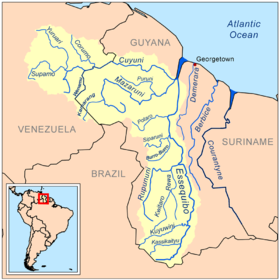
. It includes the territory between the Cuyuni River
Cuyuni River
The Cuyuni River is a South American river and a tributary of the Essequibo River. It rises in the Guiana Highlands of Venezuela where it descends northward to El Dorado, and turns eastward to meander through the tropical rain forests of Guayana Esequiba...
to the west and the Essequibo River
Essequibo River
The Esequibo River is the largest river in Guyana, and the largest river between the Orinoco and Amazon. Rising in the Acarai Mountains near the Brazil-Guyana border, the Essequibo flows to the north for 1,010 km through forest and savanna into the Atlantic Ocean.-Geography:There are countless...
to the east. Guyana divides the area in six administrative regions (Barima-Waini
Barima-Waini
Barima-Waini is a region of Essequibo, Guyana, a territory in dispute by Guyana and Venezuela, located in the northwest of the country. It covers an area of 20,339 km²...
, Cuyuni-Mazaruni
Cuyuni-Mazaruni
Cuyuni-Mazaruni is a region of Esequiban Guyana, a territory in dispute by Guyana and Venezuela, bordering the regions of Barima-Waini, Essequibo Islands-West Demerara and Pomeroon-Supenaam to the north, the region of Upper Demerara-Berbice to the east, the region of Potaro-Siparuni and Brazil to...
, Pomeroon-Supenaam
Pomeroon-Supenaam
Pomeroon-Supenaam is a region in Guyana, bordering the Atlantic Ocean to the north, the region of Essequibo Islands-West Demerara to the east, the region of Cuyuni-Mazaruni to the south and the region of Barima-Waini to the west...
, Potaro-Siparuni
Potaro-Siparuni
Potaro-Siparuni is a region in Guyana, bordering the region of Cuyuni-Mazaruni to the north, the regions of Upper Demerara-Berbice and East Berbice-Corentyne to the east, the region of Upper Takutu-Upper Essequibo to the south and Brazil to the west.The main towns in the region are Kangaruma,...
, Upper Takutu-Upper Essequibo
Upper Takutu-Upper Essequibo
Upper Takutu-Upper Esequibo is a region of Guyana in the Zona de Reclamación by Venezuela, bordering the region of Potaro-Siparuni to the north, the region of East Berbice-Corentyne to the east and Brazil to the south and west. It contains the towns Lethem, Isherton, Good Hope and Surama. It is...
and Essequibo Islands-West Demerara
Essequibo Islands-West Demerara
Essequibo Islands-West Demerara is a region of Guyana, split in two by the Essequibo River. It is bordered by the Atlantic Ocean to the north, the region of Demerara-Mahaica to the east, the region of Upper Demerara-Berbice to the south and the regions ofIt contains the towns of Parika, Schoon Ord...
) while Venezuela treats it as a single entity (Guayana Esequiba or "Zona en Reclamación"). The area of the territory is 159,500 km². The territory is the subject of a long-running boundary dispute inherited from the colonial powers and complicated by the independence of Guyana in 1966. The status of the territory is today subject to the Treaty of Geneva (17 February 1966), which stipulates that both sides will agree to find a practical, peaceful and satisfactory solution to the dispute.
History
Spanish authorities in a report dated 10 July 1788 put forward the first claim:It has been stated that the south coast of the OrinocoOrinocoThe Orinoco is one of the longest rivers in South America at . Its drainage basin, sometimes called the Orinoquia, covers , with 76.3% of it in Venezuela and the remainder in Colombia...
from the point of Barima, 20 leagues more or less inland, up to the creek of Curucima, is low lying and swampy land and, consequently, reckoning all this tract as useless, very few patches of fertile land being found therein, and hardly any savannahs and pastures, it is disregarded; so taking as chief base the said creek of Curucima, or the point of the chain and ridge in the great arm of the Imataka, an imaginary line will be drawn running to the south-south-east following the slopes of the ridge of the same name which is crossed by the Rivers Aguire, Arature and Amacuro, and others, in the distance of 20 leagues, direct to the CuyuniCuyuni RiverThe Cuyuni River is a South American river and a tributary of the Essequibo River. It rises in the Guiana Highlands of Venezuela where it descends northward to El Dorado, and turns eastward to meander through the tropical rain forests of Guayana Esequiba...
; from there it will run on to the Masaruni and Essequibo, parallel to the sources of the Berbis and Surinama; this is the directing line of the course which the new Settlements and foundations proposed must follow.
When Spain
Spain
Spain , officially the Kingdom of Spain languages]] under the European Charter for Regional or Minority Languages. In each of these, Spain's official name is as follows:;;;;;;), is a country and member state of the European Union located in southwestern Europe on the Iberian Peninsula...
created the Captaincy General of Venezuela
Captaincy General of Venezuela
The Captaincy General of Venezuela was an administrative district of colonial Spain, created in 1777 to provide more autonomy for the provinces of Venezuela, previously under the jurisdiction of the Viceroyalty of New Granada and the Audiencia of Santo Domingo...
, the Essequibo river was claimed as the natural border between Spanish territory and the Dutch
Dutch Republic
The Dutch Republic — officially known as the Republic of the Seven United Netherlands , the Republic of the United Netherlands, or the Republic of the Seven United Provinces — was a republic in Europe existing from 1581 to 1795, preceding the Batavian Republic and ultimately...
colonies of Demerara
Demerara
Demerara was a region in South America in what is now Guyana that was colonised by the Dutch in 1611. The British invaded and captured the area in 1796...
, Berbice
Berbice
Berbice is a region along the Berbice River in Guyana, which was between 1627 and 1815 a colony of the Netherlands. After having been ceded to the United Kingdom in the latter year, it was merged with Essequibo and Demerara to form the colony of British Guiana in 1831...
and Essequibo
Essequibo (colony)
Essequibo was from 1616 to 1814 a Dutch colony in the region of the Essequibo river on the north coast of South America. The colony formed a part of the colonies that are known under the collective name of Dutch Guyana.- History :...
. Under the Anglo-Dutch Treaty of 1814
Anglo-Dutch Treaty of 1814
The Anglo-Dutch Treaty of 1814 was a treaty signed between Great Britain and the Netherlands in London on August 13, 1814...
those colonies were transferred to Great Britain
United Kingdom
The United Kingdom of Great Britain and Northern IrelandIn the United Kingdom and Dependencies, other languages have been officially recognised as legitimate autochthonous languages under the European Charter for Regional or Minority Languages...
. In 1831, Britain merged Berbice, Demerara, and Essequibo into British Guiana
British Guiana
British Guiana was the name of the British colony on the northern coast of South America, now the independent nation of Guyana.The area was originally settled by the Dutch at the start of the 17th century as the colonies of Essequibo, Demerara, and Berbice...
, with the Essequibo River as its west border, although many British settlers lived west of the Essequibo.
In 1819, José Rafael Revenga, at the direction of Simón Bolívar
Simón Bolívar
Simón José Antonio de la Santísima Trinidad Bolívar y Palacios Ponte y Yeiter, commonly known as Simón Bolívar was a Venezuelan military and political leader...
, complained to the British government about the presence of British settlers in territory claimed by Venezuela: "The colonists of Demerara and Berbice have usurped a large portion of land, which according to recent treaties between Spain and Holland, belongs to our country at the west of Essequibo River. It is absolutely essential that these settlers be put under the jurisdiction and obedience to our laws, or be withdrawn to their former possessions." However, the British government continued to promote colonization of territory west of the Essequibo River.
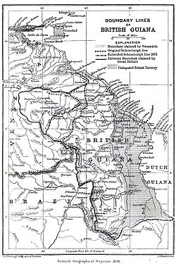
Schomburgk Line
In 1835, under the aegis of the Royal Geographical SocietyRoyal Geographical Society
The Royal Geographical Society is a British learned society founded in 1830 for the advancement of geographical sciences...
, the German
Germany
Germany , officially the Federal Republic of Germany , is a federal parliamentary republic in Europe. The country consists of 16 states while the capital and largest city is Berlin. Germany covers an area of 357,021 km2 and has a largely temperate seasonal climate...
-born, explorer and naturalist
Natural history
Natural history is the scientific research of plants or animals, leaning more towards observational rather than experimental methods of study, and encompasses more research published in magazines than in academic journals. Grouped among the natural sciences, natural history is the systematic study...
Robert Hermann Schomburgk
Robert Hermann Schomburgk
Sir Robert Hermann Schomburgk , was a German-born explorer for Great Britain who carried out geographical, ethnological and botanical studies in South America and the West Indies, and also fulfilled diplomatic missions for Great Britain in the Dominican Republic and Thailand.-Biography:Schomburgk...
conducted botanical
Botany
Botany, plant science, or plant biology is a branch of biology that involves the scientific study of plant life. Traditionally, botany also included the study of fungi, algae and viruses...
and geographical
Geography
Geography is the science that studies the lands, features, inhabitants, and phenomena of Earth. A literal translation would be "to describe or write about the Earth". The first person to use the word "geography" was Eratosthenes...
exploration of British Guiana. This resulted in a sketch of the territory with a line marking what he believed to be the western boundary claimed by the Dutch. As a result of this, he was commissioned in 1840 by the British government to survey Guiana's boundaries. This survey resulted in what came to be known as the "Schomburgk Line". Schomburgk's initial sketch, which had been published in 1840, was the only version of the "Schomburgk Line" published until 1886, which led to later accusations by US
United States
The United States of America is a federal constitutional republic comprising fifty states and a federal district...
President Grover Cleveland
Grover Cleveland
Stephen Grover Cleveland was the 22nd and 24th president of the United States. Cleveland is the only president to serve two non-consecutive terms and therefore is the only individual to be counted twice in the numbering of the presidents...
that the line had been extended "in some mysterious way".
The Line went well beyond the area of British occupation, and gave British Guiana control of the mouth of the Orinoco
Orinoco
The Orinoco is one of the longest rivers in South America at . Its drainage basin, sometimes called the Orinoquia, covers , with 76.3% of it in Venezuela and the remainder in Colombia...
River. Venezuela disputed Schomburgk's survey, claiming that the Britain had illegally acquired an extra 30000 square miles (77,699.6 km²) of territory. In 1840 Venezuela claimed all of Guyana west of the Essequibo River — 62% of Guyana's territory. Britain and Venezuela argued over the boundary between British Guiana and Venezuela for much of the 19th century.
On 21 February 1881, Venezuela proposed a frontier line starting from a point one mile to the north of the Moruka River
Moruka River
The Moruka River is a river in the Barima-Waini region of northern Guyana.Settlements along the river include Santa Rosa, Kamwatta and Asakata....
, drawn from there westward to the 60th meridian
60th meridian west
The meridian 60° west of Greenwich is a line of longitude that extends from the North Pole across the Arctic Ocean, Greenland, North America, the Atlantic Ocean, South America, the Southern Ocean, and Antarctica to the South Pole....
and running south along that meridian. This would have granted the Barima District to Venezuela.
In October 1886 Britain declared the Schomburgk Line to be the provisional frontier of British Guiana, and in February 1887 Venezuela severed diplomatic relations. Venezuela appealed to the United States to intervene, citing the Monroe Doctrine
Monroe Doctrine
The Monroe Doctrine is a policy of the United States introduced on December 2, 1823. It stated that further efforts by European nations to colonize land or interfere with states in North or South America would be viewed as acts of aggression requiring U.S. intervention...
as justification. The United States expressed concern but did little in the way of resolving the situation, until the Venezuela Crisis of 1895
Venezuela Crisis of 1895
The Venezuela Crisis of 1895 occurred over Venezuela's longstanding dispute with the United Kingdom about the territory of Guayana Esequiba, which Britain claimed as part of British Guiana and Venezuela saw as Venezuelan territory...
.
Venezuela Crisis of 1895
The longstanding dispute became a diplomatic crisis in 1895. Venezuela hired William Lindsay ScruggsWilliam Lindsay Scruggs
William Lindsay Scruggs was an American author, lawyer, and diplomat. He was a scholar of South American foreign policy and U.S. ambassador to Colombia and Venezuela. He played a key role in the Venezuela Crisis of 1895 and helped shape the modern interpretation of the Monroe Doctrine.- Early...
as its lobbyist in Washington, D.C.
Washington, D.C.
Washington, D.C., formally the District of Columbia and commonly referred to as Washington, "the District", or simply D.C., is the capital of the United States. On July 16, 1790, the United States Congress approved the creation of a permanent national capital as permitted by the U.S. Constitution....
Scruggs took up Venezula's argument that British action violated the Monroe Doctrine
Monroe Doctrine
The Monroe Doctrine is a policy of the United States introduced on December 2, 1823. It stated that further efforts by European nations to colonize land or interfere with states in North or South America would be viewed as acts of aggression requiring U.S. intervention...
. Scruggs used his influence to get the US government to accept this claim and get involved. President Grover Cleveland
Grover Cleveland
Stephen Grover Cleveland was the 22nd and 24th president of the United States. Cleveland is the only president to serve two non-consecutive terms and therefore is the only individual to be counted twice in the numbering of the presidents...
adopted a broad interpretation of the Doctrine that did not just simply forbid new European colonies but declared an American interest in any matter within the hemisphere. British prime minister Lord Salisbury and British ambassador to the US Lord Pauncefote
Julian Pauncefote, 1st Baron Pauncefote
Julian Pauncefote, 1st Baron Pauncefote GCB, GCMG, PC , known as Sir Julian Pauncefote between 1874 and 1899, was a British barrister, judge and diplomat...
both misjudged the importance the American government placed on the dispute. The key issue in the crisis became Britain's refusal to include the territory east of the Schomburgk Line in the proposed international arbitration. Ultimately Britain backed down and and tacitly accepted the US right to intervene under the Monroe Doctrine. This US intervention forced Britain to accept arbitration of the entire disputed territory.
Arbitration
The rival claims were presented to a tribunal of six arbitrators: two from Britain, two from the US (representing Venezuela's interest) and two from RussiaRussia
Russia or , officially known as both Russia and the Russian Federation , is a country in northern Eurasia. It is a federal semi-presidential republic, comprising 83 federal subjects...
, who were presumed neutral. Venezuela reiterated its claim to the district immediately west of the Essequibo, and claimed that the boundary should run from the mouth of the Moruka River southwards to the Cuyuni River, near its junction with the Mazaruni River
Mazaruni River
The Mazaruni River is a river in northern Guyana, running from its source in the remote western forests of the Pakaraima Mountains to its confluence with the Cuyuni River near Bartica...
, and then along the east bank of the Essequibo to the Brazil
Brazil
Brazil , officially the Federative Republic of Brazil , is the largest country in South America. It is the world's fifth largest country, both by geographical area and by population with over 192 million people...
ian frontier. In 1899 the Tribunal ruled largely in favour of Britain. The Schomburgk Line was, with two deviations, established as the border between British Guiana and Venezuela. One deviation was that Venezuela received Barima Point at the mouth of the Orinoco, giving it undisputed control of the river, and thus the ability to levy duties on Venezuelan commerce. The second placed the border at the Wenamu River
Wenamu River
Wenamu River is a river in South America. It forms a portion of the international boundary betrween Venezuela and Guyana. It is part of the Essequibo River basin.-References:*Rand McNally, The New International Atlas, 1993....
rather than the Cuyuni River, giving Venezuela substantial territory east of the line. However, Britain received most of the disputed territory, and all of the gold
Gold
Gold is a chemical element with the symbol Au and an atomic number of 79. Gold is a dense, soft, shiny, malleable and ductile metal. Pure gold has a bright yellow color and luster traditionally considered attractive, which it maintains without oxidizing in air or water. Chemically, gold is a...
mines.
Dispute renewed
Curtis, Mallet-Prevost, Colt & Mosle
Curtis, Mallet-Prevost, Colt & Mosle LLP is a New York-based international law firm with 260 attorneys in 15 offices worldwide. In 2009, its declared revenues were approximately $135 million...
, the Official Secretary of the U.S./Venezuela delegation in the Tribunal of Arbitration. This document was written in 1944 to be published only after Mallet-Prevost's death. Mallet-Prevost surmised from the private behavior of the judges that there had a political deal between Russia and Britain. Mallet-Prevost said that the Russian chair of the panel, Friedrich Martens
Friedrich Martens
Friedrich Fromhold Martens, or Friedrich Fromhold von Martens, also known as Fyodor Fyodorovich Martens in Russian and Frédéric Frommhold Martens in French was a diplomat and jurist in service of the Russian Empire who made important contributions to the science of international law...
, had visited Britain with the two British arbitrators in the summer of 1899, and subsequently had offered the two American judges a choice between accepting a unanimous award along the lines ultimately agreed, or a 3:2 majority opinion even more favourable to the British. The alternative would have followed the Schomburgk Line entirely, and given the mouth of the Orinoco to the British. Mallet-Prevost said that the American judges and Venezuelan counsel were disgusted at the situation and considered the 3:2 option with a strongly worded minority opinion, but ultimately went along with Martens to avoid depriving Venezuela of even more territory. As a result of Mallet-Prevost's claims, Venezuela revived its claim to the disputed territory.
Venezuela formally raised the issue again in 1962, four years before Guyana won independence from Britain. Venezuela alleged several improprieties and vices in the ruling, such as Ultra Petita (the referees decreed freedom of navigation in the Amacuro and Barima rivers, and drew the border between British Guiana and Brazil, issues that they never were asked to settle), and the alleged Russia-UK deal noted above. At a meeting in Geneva
Geneva
Geneva In the national languages of Switzerland the city is known as Genf , Ginevra and Genevra is the second-most-populous city in Switzerland and is the most populous city of Romandie, the French-speaking part of Switzerland...
in 1966, Britain and Venezuela agreed to receive recommendations from a representative of the UN Secretary General on ways to settle the dispute peacefully, by means of the Geneva Treaty (1966). Diplomatic contacts between the two countries and the Secretary General's representative continue. The Venezuelan claim of the nullity of the 1899 ruling has been acknowledged by several foreign scholars and jurists, such as J. Gillis Wetter of Sweden
Sweden
Sweden , officially the Kingdom of Sweden , is a Nordic country on the Scandinavian Peninsula in Northern Europe. Sweden borders with Norway and Finland and is connected to Denmark by a bridge-tunnel across the Öresund....
, in his work The International Arbitral Process (1979), and also Héctor Gross Espiell of Uruguay
Uruguay
Uruguay ,officially the Oriental Republic of Uruguay,sometimes the Eastern Republic of Uruguay; ) is a country in the southeastern part of South America. It is home to some 3.5 million people, of whom 1.8 million live in the capital Montevideo and its metropolitan area...
, and Eduardo Jiménez de Aréchaga.
In its note of recognition of the independence of Guyana on 26 May 1966, Venezuela stated:
Venezuela recognises as territory of the new State the one which is located on the east of the right bank of the Essequibo River, and reiterates before the new State, and before the international community, that it expressly reserves its rights of territorial sovereignty over all the zone located on the west bank of the above-mentioned river. Therefore, the Guyana-Essequibo territory over which Venezuela expressly reserves its sovereign rights, limits on the east by the new State of Guyana, through the middle line of the Essequibo River, beginning from its source and on to its mouth in the Atlantic Ocean.
Venezuelan maps produced since 1970 show the entire area from the eastern bank of the Essequibo, including the islands in the river, as Venezuelan territory. On some maps, the western Essequibo region is called the "Zone in Reclamation".
See also
- Gran ColombiaGran ColombiaGran Colombia is a name used today for the state that encompassed much of northern South America and part of southern Central America from 1819 to 1831. This short-lived republic included the territories of present-day Colombia, Venezuela, Ecuador, Panama, northern Peru and northwest Brazil. The...
- Guayana RegionGuayana RegionThe Guayana Region is an administrative region of Venezuela.The region has a population of 1,383,297 inhabitants and a territory of 458,344 km². It borders the independent nation of Guyana which forms part of The Guyanas...
- Essequibo (colony)Essequibo (colony)Essequibo was from 1616 to 1814 a Dutch colony in the region of the Essequibo river on the north coast of South America. The colony formed a part of the colonies that are known under the collective name of Dutch Guyana.- History :...