
Great Fire of 1910
Encyclopedia
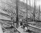
The Great Fire of 1910 was a wildfire
which burned about three million acres (12,000 km², approximately the size of Connecticut
) in northeast Washington, northern Idaho
(the panhandle), and western Montana
. The area burned included parts of the Bitterroot
, Cabinet
, Clearwater
, Coeur d'Alene
, Flathead
, Kaniksu
, Kootenai
, Lewis and Clark
, Lolo
, and St. Joe
national forests. The firestorm burned over two days (August 20–21, 1910), and killed 87 people, including 78 firefighters. It is believed to be the largest, although not the deadliest, fire in recorded U.S. history.
(then called the National Forest Service) was only five years old at the time and unprepared for the possibilities of this dry summer. Later the U.S. Army was brought in to help fight the blaze.
Smoke from the fire was said to have been seen as far east as Watertown, New York and as far south as Denver, Colorado
. It was reported that at night, 500 miles (804.7 km) out into the Pacific Ocean, ships could not navigate by the stars because the sky was cloudy with smoke.
.
The most famous story of survival was that of Ed Pulaski
, a U.S. Forest Service ranger who led a large group of his men to safety in an abandoned prospect mine
outside of Wallace, Idaho
, just as they were about to be overtaken by the fire. It is said that Pulaski fought off the flames at the mouth of the shaft until he passed out like the others. Around midnight, a man announced that he, at least, was getting out of there. Knowing that they would have no chance of survival if they ran, Pulaski drew his pistol, threatening to shoot the first person who tried to leave. In the end, all but five of the forty or so men survived.
 The fire was finally extinguished when another cold front swept in, bringing steady rain. Several towns were completely destroyed by the fire:
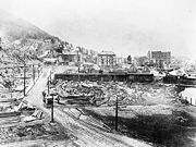
Additionally one third of Wallace, Idaho
, was burned to the ground, with an estimated $1 million dollars (calculation 1910) in damage. Passenger trains took thousands of Wallace residents to Spokane, Washington
, and Missoula, Montana
. Another train with 1,000 people from Avery took refuge in a tunnel after racing across a burning trestle. Other towns with severe damage included: Burke
, Kellogg
, Murray, and Osburn
, Idaho. The towns of Avery and Saltese as well as a major part of Wallace were saved by backfires.
The Fire of 1910 shaped the U.S. Forest Service. Before the epic event, there were many debates on how to handle forest fires; whether to let them burn because they were a part of nature and were expensive to fight, or to fight them in order to protect the forests. After the devastation of the Big Blowup, it was decided that the U.S. Forest Service was to prevent and battle against every wildfire. More recently, this absolutist attitude to wildfires has been criticized for altering the natural disturbance mechanisms that drive forest ecosystem structure.
Wildfire
A wildfire is any uncontrolled fire in combustible vegetation that occurs in the countryside or a wilderness area. Other names such as brush fire, bushfire, forest fire, desert fire, grass fire, hill fire, squirrel fire, vegetation fire, veldfire, and wilkjjofire may be used to describe the same...
which burned about three million acres (12,000 km², approximately the size of Connecticut
Connecticut
Connecticut is a state in the New England region of the northeastern United States. It is bordered by Rhode Island to the east, Massachusetts to the north, and the state of New York to the west and the south .Connecticut is named for the Connecticut River, the major U.S. river that approximately...
) in northeast Washington, northern Idaho
Idaho
Idaho is a state in the Rocky Mountain area of the United States. The state's largest city and capital is Boise. Residents are called "Idahoans". Idaho was admitted to the Union on July 3, 1890, as the 43rd state....
(the panhandle), and western Montana
Montana
Montana is a state in the Western United States. The western third of Montana contains numerous mountain ranges. Smaller, "island ranges" are found in the central third of the state, for a total of 77 named ranges of the Rocky Mountains. This geographical fact is reflected in the state's name,...
. The area burned included parts of the Bitterroot
Bitterroot National Forest
Bitterroot National Forest comprises 1.587 million acres in west-central Montana and eastern Idaho, of the United States. It is located primarily in Ravalli County, Montana , but also has acreage in Idaho County, Idaho , and Missoula County, Montana .Founded in 1898, the forest is located in the...
, Cabinet
Cabinet National Forest
Cabinet National Forest was established in Idaho and Montana by the U.S. Forest Service on March 2, 1907 with , mostly in Montana. On July 1, 1954 it was divided among Kaniksu, Kootenai and Lolo National Forests. -External links:*...
, Clearwater
Clearwater National Forest
Clearwater National Forest is located in North Central Idaho in the northwestern United States. The forest is bounded on the east by the state of Montana, on the north by the Idaho Panhandle National Forest, and on the south and west by the Nez Perce National Forest and Palouse Prairie.]The forest...
, Coeur d'Alene
Coeur d'Alene National Forest
The Coeur d'Alene is a U.S. National Forest located in the Idaho panhandle and is one of three forests that are aggregated into the Idaho Panhandle National Forest . Coeur d'Alene National Forest is located in Shoshone, Kootenai, and Bonner counties in northern Idaho...
, Flathead
Flathead National Forest
The Flathead National Forest is a national forest in the western part of the U.S. state of Montana. The forest covers of which about 1 million acres is designated wilderness. It is named after the Flathead Indians who lived in the area. The forest is located in the Rocky Mountains with elevations...
, Kaniksu
Kaniksu National Forest
The Kaniksu National Forest is a U.S. National Forest located in northeastern Washington, the Idaho panhandle, and northwestern Montana. The Idaho portion is one of three forests that are aggregated into the Idaho Panhandle National Forest, along with the Coeur d'Alene National Forest and St. Joe...
, Kootenai
Kootenai National Forest
Kootenai National Forest is located in the far northwestern section of Montana and the northeasternmost lands in the Idaho panhandle, United States along the Canadian border. Of the 2.2 million acres administered by the forest, less than 3 percent is located in the state of Idaho. Forest...
, Lewis and Clark
Lewis and Clark National Forest
Lewis and Clark National Forest is located in west central Montana, United States. Spanning , the forest is managed as two separate zones. The eastern sections, under the Jefferson Division, is a mixture of grass and shrublands dotted with "island" pockets of forested areas. Here, cattle leases to...
, Lolo
Lolo National Forest
Lolo National Forest is located in western Montana, United States with the western boundary being the state of Idaho. The forest spans 2 million acres and includes four wilderness areas; the Scapegoat and the Bob Marshall Wilderness are partially within the forest while the Welcome Creek and...
, and St. Joe
St. Joe National Forest
The St. Joe National Forest is a U.S. National Forest located in the Idaho panhandle and is one of three forests that are aggregated into the Idaho Panhandle National Forest . In descending order of land area St. Joe National Forest is located in parts of Shoshone, Latah, Clearwater, and Benewah...
national forests. The firestorm burned over two days (August 20–21, 1910), and killed 87 people, including 78 firefighters. It is believed to be the largest, although not the deadliest, fire in recorded U.S. history.
Origin
There were a great number of problems that contributed to the destruction of the Great Fire of 1910. The fire season started early that year, because the summer of 1910 was hot and dry like no other. This drought caused there to be plenty of dry vegetation, so forests were teeming with dry fuel. Fires were set by hot cinders flung from locomotives, sparks, lightning, and backfiring crews, and by mid August there were 1,000 to 3,000 fires burning in Idaho, Montana, Washington and British Columbia.The Big Blowup
On August 20, a cold front blew in and brought hurricane-force winds, whipping the hundreds of small fires into one or two blazing infernos. The fire was impossible to fight; there were too few men and too little supplies. The United States Forest ServiceUnited States Forest Service
The United States Forest Service is an agency of the United States Department of Agriculture that administers the nation's 155 national forests and 20 national grasslands, which encompass...
(then called the National Forest Service) was only five years old at the time and unprepared for the possibilities of this dry summer. Later the U.S. Army was brought in to help fight the blaze.
Smoke from the fire was said to have been seen as far east as Watertown, New York and as far south as Denver, Colorado
Denver, Colorado
The City and County of Denver is the capital and the most populous city of the U.S. state of Colorado. Denver is a consolidated city-county, located in the South Platte River Valley on the western edge of the High Plains just east of the Front Range of the Rocky Mountains...
. It was reported that at night, 500 miles (804.7 km) out into the Pacific Ocean, ships could not navigate by the stars because the sky was cloudy with smoke.
Firefighters
The entire 28-man "Lost Crew" was overcome by flames and perished on Setzer Creek outside of Avery, IdahoAvery, Idaho
Avery is a small unincorporated town nestled in the St. Joe River Valley in Shoshone County, Idaho, United States. Avery is located in the middle of the St. Joe District of the Idaho Panhandle National Forest...
.
The most famous story of survival was that of Ed Pulaski
Ed Pulaski
Edward C. "Ed" Pulaski was a U.S. Forest Service ranger based in Wallace, Idaho. Pulaski traveled west and worked as a miner, railroad worker, and ranch foreman before joining the forest service in 1908.-Great Fire of 1910:...
, a U.S. Forest Service ranger who led a large group of his men to safety in an abandoned prospect mine
Edward Pulaski Tunnel and Placer Creek Escape Route
The Edward Pulaski Tunnel and Placer Creek Escape Route are two adjacent sites used by firefighter Edward Pulaski in the Great Fire of 1910 to save the lives of himself and his crew....
outside of Wallace, Idaho
Wallace, Idaho
Wallace is a historic city in the Panhandle region of the U.S. state of Idaho and the county seat of Shoshone County in the Silver Valley mining district...
, just as they were about to be overtaken by the fire. It is said that Pulaski fought off the flames at the mouth of the shaft until he passed out like the others. Around midnight, a man announced that he, at least, was getting out of there. Knowing that they would have no chance of survival if they ran, Pulaski drew his pistol, threatening to shoot the first person who tried to leave. In the end, all but five of the forty or so men survived.
Aftermath
- Idaho:
- Falcon
- Grand Forks
- Montana:
- De BorgiaDe Borgia, MontanaDe Borgia is a census-designated place in Mineral County, Montana, United States. The population was 69 at the 2000 census.-Geography:De Borgia is located at ....
- HauganHaugan, MontanaHaugan is an unincorporated community in Mineral County, Montana, United States. Haugan is situated east of the Idaho border and west of Missoula on Interstate 90 at the Haugan Exit #16....
- Henderson
- TaftTaft, MontanaTaft is a ghost town in Mineral County, Montana, United States. Located in the Bitterroot Range near the Idaho border. It was a thriving railroad town circa 1908, named after William H...
- Tuscor
- De Borgia
Additionally one third of Wallace, Idaho
Wallace, Idaho
Wallace is a historic city in the Panhandle region of the U.S. state of Idaho and the county seat of Shoshone County in the Silver Valley mining district...
, was burned to the ground, with an estimated $1 million dollars (calculation 1910) in damage. Passenger trains took thousands of Wallace residents to Spokane, Washington
Spokane, Washington
Spokane is a city located in the Northwestern United States in the state of Washington. It is the largest city of Spokane County of which it is also the county seat, and the metropolitan center of the Inland Northwest region...
, and Missoula, Montana
Missoula, Montana
Missoula is a city located in western Montana and is the county seat of Missoula County. The 2010 Census put the population of Missoula at 66,788 and the population of Missoula County at 109,299. Missoula is the principal city of the Missoula Metropolitan Area...
. Another train with 1,000 people from Avery took refuge in a tunnel after racing across a burning trestle. Other towns with severe damage included: Burke
Burke, Idaho
Burke is a ghost town in Burke-Canyon in Shoshone County, Idaho, United States. Once a thriving silver and lead town, it is now far smaller than at its height. In 2002, about 300 people lived in or nearby Burke Canyon...
, Kellogg
Kellogg, Idaho
Kellogg is a city in the Silver Valley of Shoshone County, Idaho, United States, in the Idaho Panhandle region. The city lies near the Coeur d'Alene National Forest and about east-southeast of Coeur d'Alene along Interstate 90...
, Murray, and Osburn
Osburn, Idaho
Osburn is a city in Shoshone County, Idaho, United States. The population was 1,555 at the 2010 census.-Geography:Osburn is located at .According to the United States Census Bureau, the city has a total area of , all land....
, Idaho. The towns of Avery and Saltese as well as a major part of Wallace were saved by backfires.
The Fire of 1910 shaped the U.S. Forest Service. Before the epic event, there were many debates on how to handle forest fires; whether to let them burn because they were a part of nature and were expensive to fight, or to fight them in order to protect the forests. After the devastation of the Big Blowup, it was decided that the U.S. Forest Service was to prevent and battle against every wildfire. More recently, this absolutist attitude to wildfires has been criticized for altering the natural disturbance mechanisms that drive forest ecosystem structure.
See also
- Baudette Fire of 1910Baudette Fire of 1910The Baudette Fire, also known as the Spooner-Baudette Fire, was a large wildfire that burned in Lake of the Woods County, Minnesota, including nearly all of the twin towns of Spooner and Baudette on October 7, 1910. In addition to Baudette, the fire also burned the villages of Graceton, Pitt,...
in northern Minnesota - Avery DepotAvery DepotThe Avery Depot in Avery, Idaho was built by the Chicago, Milwaukee, St. Paul and Pacific Railroad in 1909 as part of its Pacific Extension into the Pacific Northwest from Chicago, Illinois....
, a train depot in Avery, IdahoAvery, IdahoAvery is a small unincorporated town nestled in the St. Joe River Valley in Shoshone County, Idaho, United States. Avery is located in the middle of the St. Joe District of the Idaho Panhandle National Forest...
used as an evacuation site - Edward Pulaski Tunnel and Placer Creek Escape RouteEdward Pulaski Tunnel and Placer Creek Escape RouteThe Edward Pulaski Tunnel and Placer Creek Escape Route are two adjacent sites used by firefighter Edward Pulaski in the Great Fire of 1910 to save the lives of himself and his crew....
an abandoned prospect mine used by Ed PulaskiEd PulaskiEdward C. "Ed" Pulaski was a U.S. Forest Service ranger based in Wallace, Idaho. Pulaski traveled west and worked as a miner, railroad worker, and ranch foreman before joining the forest service in 1908.-Great Fire of 1910:...
to save himeself and his crew
Further reading
- Cohen, Steve, and Donald C. Miller, (1978). - The Big Burn: The Northwest's Forest Fire of 1910. - Missoula, Montana: Pictorial Histories Publishing Company. - .
- Egan, TimothyTimothy EganTimothy Egan is a Pulitzer Prize winning author who resides in Seattle. He currently contributes opinion columns to The New York Times as the paper's Pacific Northwest correspondent...
, (2009). - The Big Burn: Teddy Roosevelt and the Fire That Saved America - Houghton Mifflin Harcourt - ISBN 0618968415. - "When the Mountains Roared: Stories of the 1910 Fire". - Forest History Society.
- Spencer, Betty Goodwin, (1956). - The Big Blowup. - Caldwell, Idaho: Caxton Printers. - .
External links
- The 1910 Fires, a history of the Great Fire of 1910 from the Forest History SocietyForest History SocietyThe Forest History Society is an American non-profit organization dedicated to the preservation of forest and conservation history. The society was established in 1946 and incorporated in 1955....
website. - "The Big Burn of 1910". - MissoulianMissoulianThe Missoulian is a daily newspaper printed in Missoula, Montana. Its circulation is 34,855 on Sundays, 30,466 on weekdays. The newspaper is owned by Lee Enterprises. The Missoulian is the 2nd largest published newspaper in Montana, just behind the Billings Gazette...
- "1910 Fire In Mineral County". - Mineral County Historical Society. - c/o Mineral County Information and Commerce.
- "1910 Fire Commemoration Information Site". - Region One US Forest Service On-line Exhibit; with lots of information, maps, photos, a bibliography, etc.