

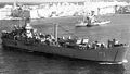
Grand Harbour
Encyclopedia
Grand Harbour is a natural harbour on the island of Malta
. It has been used as a harbour since at least Phoenicia
n times. The natural harbour has been greatly improved with extensive docks
and wharves, and has been massively fortified.
and is bounded to the south by Ricasoli Point. Its north west shore is formed by the Scebarras peninsula, which is largely covered by the city of Valletta
and its suburb
Floriana
. This peninsula also divides Grand Harbour from a second parallel natural harbour, Marsamxett Harbour
. The main waterway of Grand Harbour continues inland almost to Marsa. The south eastern shore of the harbour is formed by a number of inlets and headlands, principally Rinella Creek, Kalkara Creek, Dockyard Creek, and French Creek, which are covered by Kalkara
and the Three Cities
: Cospicua
, Vittoriosa
, and Senglea
.
 With its partner harbour of Marsamxett, Grand Harbour lies at the centre of gently rising ground. Development has grown up all around the twin harbours and up the slopes so that the whole bowl is effectively one large conurbation
. Much of Malta's population lives within a three kilometer radius of Floriana. This is now one of the most densely populated areas in Europe.
for a further 170 years. It was the site in the late 16th century of a devastating tornado that killed 600 people and destroyed a shipping armada. The area was the scene of much of the fighting in the First Siege of Malta
when the Turks
attempted to eject the Knights of St John. The whole area was savagely bombed during the Second Siege of Malta
during World War II
, as the docks and military installations around the port
were legitimate targets for Axis
bombers. However collateral damage
wrecked much of Valletta and The Three Cities, and caused large numbers of civilian casualties
.
The harbours and docks are still active but with the departure of the British Military the harbour lost much of its military significance. A considerable part of Malta's commercial
shipping
is now handled by the new free port
at Kalafrana
, so the harbour is much quieter than it was in the first half of the 20th century.
Around the Grand Harbour from Fort Ricasoli
's History, is set to experience a regeneration as the Maltese Government
, in September 2007, unveiled 20 proposed projects that would revamp the area while respecting its historic value.
The 20 proposals are these:
Malta
Malta , officially known as the Republic of Malta , is a Southern European country consisting of an archipelago situated in the centre of the Mediterranean, south of Sicily, east of Tunisia and north of Libya, with Gibraltar to the west and Alexandria to the east.Malta covers just over in...
. It has been used as a harbour since at least Phoenicia
Phoenicia
Phoenicia , was an ancient civilization in Canaan which covered most of the western, coastal part of the Fertile Crescent. Several major Phoenician cities were built on the coastline of the Mediterranean. It was an enterprising maritime trading culture that spread across the Mediterranean from 1550...
n times. The natural harbour has been greatly improved with extensive docks
Dock (maritime)
A dock is a human-made structure or group of structures involved in the handling of boats or ships, usually on or close to a shore.However, the exact meaning varies among different variants of the English language...
and wharves, and has been massively fortified.
Description
The harbour mouth faces north east and is bounded to the north by St Elmo's Point and further sheltered by an isolated breakwaterBreakwater (structure)
Breakwaters are structures constructed on coasts as part of coastal defence or to protect an anchorage from the effects of weather and longshore drift.-Purposes of breakwaters:...
and is bounded to the south by Ricasoli Point. Its north west shore is formed by the Scebarras peninsula, which is largely covered by the city of Valletta
Valletta
Valletta is the capital of Malta, colloquially known as Il-Belt in Maltese. It is located in the central-eastern portion of the island of Malta, and the historical city has a population of 6,098. The name "Valletta" is traditionally reserved for the historic walled citadel that serves as Malta's...
and its suburb
Suburb
The word suburb mostly refers to a residential area, either existing as part of a city or as a separate residential community within commuting distance of a city . Some suburbs have a degree of administrative autonomy, and most have lower population density than inner city neighborhoods...
Floriana
Floriana
Floriana is a town in Malta, just outside the capital city Valletta. Floriana is the birthplace of many famous Maltese, amongst which the composer of the national anthem, 'L-Innu Malti', Robert Samut; former Bishop of Malta Dom Mauro Caruana, the poet Oliver Friggieri, and Swedish Idol winner...
. This peninsula also divides Grand Harbour from a second parallel natural harbour, Marsamxett Harbour
Marsamxett Harbour
Marsamxett Harbour, also referred as Marsamuscetto in many ancient documents, is the northern of Valletta's two natural harbours on the island of Malta, separated from the southern one by the Valletta peninsula. To the north it is bounded by Gżira and Sliema as far as Dragut Point and extends...
. The main waterway of Grand Harbour continues inland almost to Marsa. The south eastern shore of the harbour is formed by a number of inlets and headlands, principally Rinella Creek, Kalkara Creek, Dockyard Creek, and French Creek, which are covered by Kalkara
Kalkara
Il-Kalkara is a small picturesque village in Malta, with a population of 2,856 . The name is derived from the Latin word for lime , and it is believed that there was a lime kiln present there since Roman times. Kalkara forms part of the inner harbour area and occupies the area around Kalkara Creek...
and the Three Cities
Three Cities
The Three Cities is a collective description of the three fortified cities of Cospicua, Vittoriosa, and Senglea on the Island of Malta, which are enclosed by the massive line of fortification created by the Knights of St John, the Cottonera Lines....
: Cospicua
Cospicua
Ċittà Cottonera, Ċittà Cospicua, Cospicua is a double-fortified harbour city on the Mediterranean island of Malta. It is the largest of the Three Cities. It was also given a title as Citta' Cottonera, but erroneously the title is now used to define the whole region...
, Vittoriosa
Birgu
Birgu is an ancient city in Malta. It played a vital role in the Siege of Malta in 1565. Its population stood at 2,633 in December 2008.-History:...
, and Senglea
Senglea
Senglea is a fortified city in the east of Malta, mainly in the Grand Harbour area. It is one of the Three Cities in the east of Malta, the other two being Cospicua and Vittoriosa. The city of Senglea is also called Civitas Invicta, because it managed to resist the Ottoman invasion at the Great...
.
Conurbation
A conurbation is a region comprising a number of cities, large towns, and other urban areas that, through population growth and physical expansion, have merged to form one continuous urban and industrially developed area...
. Much of Malta's population lives within a three kilometer radius of Floriana. This is now one of the most densely populated areas in Europe.
History
Grand Harbour was the base for the Knights of St John for 268 years, and after their departure became a strategic base for the BritishBritish Empire
The British Empire comprised the dominions, colonies, protectorates, mandates and other territories ruled or administered by the United Kingdom. It originated with the overseas colonies and trading posts established by England in the late 16th and early 17th centuries. At its height, it was the...
for a further 170 years. It was the site in the late 16th century of a devastating tornado that killed 600 people and destroyed a shipping armada. The area was the scene of much of the fighting in the First Siege of Malta
Siege of Malta (1565)
The Siege of Malta took place in 1565 when the Ottoman Empire invaded the island, then held by the Knights Hospitaller .The Knights, together with between 4-5,000 Maltese men,...
when the Turks
Ottoman Empire
The Ottoman EmpireIt was usually referred to as the "Ottoman Empire", the "Turkish Empire", the "Ottoman Caliphate" or more commonly "Turkey" by its contemporaries...
attempted to eject the Knights of St John. The whole area was savagely bombed during the Second Siege of Malta
Siege of Malta (1940)
The Siege of Malta was a military campaign in the Mediterranean Theatre of the Second World War. From 1940-1942, the fight for the control of the strategically important island of Malta pitted the air forces and navies of Fascist Italy and Nazi Germany against the Royal Air Force and the Royal...
during World War II
World War II
World War II, or the Second World War , was a global conflict lasting from 1939 to 1945, involving most of the world's nations—including all of the great powers—eventually forming two opposing military alliances: the Allies and the Axis...
, as the docks and military installations around the port
Port
A port is a location on a coast or shore containing one or more harbors where ships can dock and transfer people or cargo to or from land....
were legitimate targets for Axis
Axis Powers
The Axis powers , also known as the Axis alliance, Axis nations, Axis countries, or just the Axis, was an alignment of great powers during the mid-20th century that fought World War II against the Allies. It began in 1936 with treaties of friendship between Germany and Italy and between Germany and...
bombers. However collateral damage
Collateral damage
Collateral damage is damage to people or property that is unintended or incidental to the intended outcome. The phrase is prevalently used as an euphemism for civilian casualties of a military action.-Etymology:...
wrecked much of Valletta and The Three Cities, and caused large numbers of civilian casualties
Civilian casualties
Civilian casualties is a military term describing civilian or non-combatant persons killed, injured, or imprisoned by military action. The description of civilian casualties includes any form of military action regardless of whether civilians were targeted directly...
.
The harbours and docks are still active but with the departure of the British Military the harbour lost much of its military significance. A considerable part of Malta's commercial
Trade
Trade is the transfer of ownership of goods and services from one person or entity to another. Trade is sometimes loosely called commerce or financial transaction or barter. A network that allows trade is called a market. The original form of trade was barter, the direct exchange of goods and...
shipping
Shipping
Shipping has multiple meanings. It can be a physical process of transporting commodities and merchandise goods and cargo, by land, air, and sea. It also can describe the movement of objects by ship.Land or "ground" shipping can be by train or by truck...
is now handled by the new free port
Free port
A free port or free zone , sometimes also called a bonded area is a port, port area or other area with relaxed jurisdiction with respect to the country of location...
at Kalafrana
Marsaxlokk
Marsaxlokk is a traditional fishing village located in the south-eastern part of Malta, with a population of 3,277 people . The village’s name comes from marsa, which means "port" and xlokk, which is the local name for south east...
, so the harbour is much quieter than it was in the first half of the 20th century.
Around the Grand Harbour from Fort RicasoliFort RicasoliFort Ricasoli is a large fortification on the island of Malta. The fort was built by the Knights of Malta between 1670 and 1693.-General:It occupies the promontory known as Gallows Point that forms the eastern arm of Grand Harbour, and the north shore of Rinella Creek. Together with Fort St...
to Fort St. Elmo
- Fort RicasoliFort RicasoliFort Ricasoli is a large fortification on the island of Malta. The fort was built by the Knights of Malta between 1670 and 1693.-General:It occupies the promontory known as Gallows Point that forms the eastern arm of Grand Harbour, and the north shore of Rinella Creek. Together with Fort St...
- Rinella Bay
- Bighi
- KalkaraKalkaraIl-Kalkara is a small picturesque village in Malta, with a population of 2,856 . The name is derived from the Latin word for lime , and it is believed that there was a lime kiln present there since Roman times. Kalkara forms part of the inner harbour area and occupies the area around Kalkara Creek...
Creek- Marina Road, KalkaraKalkaraIl-Kalkara is a small picturesque village in Malta, with a population of 2,856 . The name is derived from the Latin word for lime , and it is believed that there was a lime kiln present there since Roman times. Kalkara forms part of the inner harbour area and occupies the area around Kalkara Creek...
- Kalkara Strand, Kalkara
- Mandraġġ Strand, BirguBirguBirgu is an ancient city in Malta. It played a vital role in the Siege of Malta in 1565. Its population stood at 2,633 in December 2008.-History:...
- Marina Road, Kalkara
- Fort St. Angelo
- Dockyard Creek or Cottonera Marina
- St. Angelo Strand, Birgu
- Xatt il-Forn, Birgu
- Xatt ir-Risq, Birgu
- Xatt San Lawrenz, Birgu
- Dock No. 1, Bormla
- Xatt Juan B. Azzopardi, SengleaSengleaSenglea is a fortified city in the east of Malta, mainly in the Grand Harbour area. It is one of the Three Cities in the east of Malta, the other two being Cospicua and Vittoriosa. The city of Senglea is also called Civitas Invicta, because it managed to resist the Ottoman invasion at the Great...
- Fort Saint MichaelFort Saint MichaelFort St Michael was a fortification on the island of Malta.A fort of that name was built by the Knights of Malta between 1551 and 1565 on the peninsula then known as Isla St Michael formed by Dockyard Creek and French Creek in Grand Harbour....
- French Creek
- Dock No. 2
- Ghajn Dwieli Road
- Corradino
- Dock No. 6
- Ras Ħanżir Point
- New Port
- Shipwrights Wharf, PaolaPaola, MaltaPaola, , is a town in the Grand Harbour area of Malta, with a population of 8,856 people . It is named after its founder, the Grandmaster Antoine de Paule, but is commonly known as Raħal Ġdid, which means new town in Maltese.Paola is renowned for its shopping centres, Good Friday procession, its...
- Dock No. 7
- Xatt il-Mollijiet, Albert Town
- Church Wharf, Marsa
- Shipwrights Wharf, Paola
- Il-Menqa
- Bridge Wharf, Marsa
- Braken Wharf, Marsa
- Il-Moll tal-Ħatab, Marsa
- Moll iċ-Ċangatura, Marsa
- Xatt l-Għassara ta' l-Għeneb, Marsa
- Valletta WaterfrontValletta WaterfrontThe Valletta Waterfront, in Floriana, Malta, is baroque wharf built by Manuel Pinto de Fonseca in the 18th century. It has been thoroughly renovated by a private consortium who run the Waterfront and offer management overseeing for Malta's cruise liner business...
or Pinto Wharf, FlorianaFlorianaFloriana is a town in Malta, just outside the capital city Valletta. Floriana is the birthplace of many famous Maltese, amongst which the composer of the national anthem, 'L-Innu Malti', Robert Samut; former Bishop of Malta Dom Mauro Caruana, the poet Oliver Friggieri, and Swedish Idol winner... - Lascaris Wharf, VallettaVallettaValletta is the capital of Malta, colloquially known as Il-Belt in Maltese. It is located in the central-eastern portion of the island of Malta, and the historical city has a population of 6,098. The name "Valletta" is traditionally reserved for the historic walled citadel that serves as Malta's...
- Xatt il-Barriera, Valletta
- Taħt iż-Żiemel
- Fort St. Elmo
A Vision for Malta's Grand Harbour
The Grand Harbour, the backdrop to MaltaMalta
Malta , officially known as the Republic of Malta , is a Southern European country consisting of an archipelago situated in the centre of the Mediterranean, south of Sicily, east of Tunisia and north of Libya, with Gibraltar to the west and Alexandria to the east.Malta covers just over in...
's History, is set to experience a regeneration as the Maltese Government
Nationalist Party (Malta)
The Nationalist Party is one of two major contemporary political parties in Malta, along with the Labour Party. It was founded by Fortunato Mizzi in 1880 as the Anti-Reform Party, opposing taxation decreed by the British colonial authorities and measures to Anglicise the educational and the...
, in September 2007, unveiled 20 proposed projects that would revamp the area while respecting its historic value.
The 20 proposals are these:
- A New Cruise Liner Terminal in SengleaSengleaSenglea is a fortified city in the east of Malta, mainly in the Grand Harbour area. It is one of the Three Cities in the east of Malta, the other two being Cospicua and Vittoriosa. The city of Senglea is also called Civitas Invicta, because it managed to resist the Ottoman invasion at the Great...
- Extending the Valletta Cruise Liner Terminal
- One promenade from Ricasoli all the way to Senglea
- New yacht marina in KalkaraKalkaraIl-Kalkara is a small picturesque village in Malta, with a population of 2,856 . The name is derived from the Latin word for lime , and it is believed that there was a lime kiln present there since Roman times. Kalkara forms part of the inner harbour area and occupies the area around Kalkara Creek...
- Conversion of Sir Paul BoffaPaul BoffaSir Paul Boffa, OBE was a Maltese prime minister who took office after self-rule was reinstated by the British colonial authority following the end of World War II.-Life:...
hospital into a hotel - A new tourism and cultural sector
- A center for the audio-visual industry in Fort RicasoliFort RicasoliFort Ricasoli is a large fortification on the island of Malta. The fort was built by the Knights of Malta between 1670 and 1693.-General:It occupies the promontory known as Gallows Point that forms the eastern arm of Grand Harbour, and the north shore of Rinella Creek. Together with Fort St...
- Restoration of Villa Bighi
- Super yachts along the Senglea waterfrontCoastA coastline or seashore is the area where land meets the sea or ocean. A precise line that can be called a coastline cannot be determined due to the dynamic nature of tides. The term "coastal zone" can be used instead, which is a spatial zone where interaction of the sea and land processes occurs...
- Discontinuing the Cleaning of Tanks
- A Commercial Maritime Park
- Maritime institute
- Maritime services
- Closing down the Marsa Power Station
- AfforestationAfforestationAfforestation is the establishment of a forest or stand of trees in an area where there was no forest. Reforestation is the reestablishment of forest cover, either naturally or artificially...
of the Rinella Valley - Rinella Creek
- New maritime infrastructure in Kalkara
- The reorganisation of Xatt il-Mollijiet
- Extension of quay infrastructe in Coradino
- A Base for Towing Services in Xatt il-Knisja
External links
- Audio Tour for Valletta
- Valletta Grand Harbour - An impression of a tour around Grand Harbour
- Valletta Waterfront
- Malta Maritime Authority
- AIDAbella on its maiden call into the Grand Harbour. Cannon salute
- Visualization of new Breakwater bridge