
Glacial Lake Maumee
Encyclopedia
| Stages of Glacial Lake Maumee | ||||
| Stage | Years Ago | Elevation (ft) | Elevation (m) | Outlet |
| Highest | 14,000 | 800 | 244 | Wabash-Erie Channel |
| Lowest | 13,800 | 760 | 232 | Grand River |
| Middle | - | 780 | 238 | Imlay Outlet |
Proglacial lake
In geology, a proglacial lake is a lake formed either by the damming action of a moraine or ice dam during the retreat of a melting glacier, or by meltwater trapped against an ice sheet due to isostatic depression of the crust around the ice...
that was an ancestor of present-day Lake Erie
Lake Erie
Lake Erie is the fourth largest lake of the five Great Lakes in North America, and the tenth largest globally. It is the southernmost, shallowest, and smallest by volume of the Great Lakes and therefore also has the shortest average water residence time. It is bounded on the north by the...
. It formed about 14,000 years ago. As the Erie Lobe of the Wisconsin Glacier retreated at the end of the last ice age
Ice age
An ice age or, more precisely, glacial age, is a generic geological period of long-term reduction in the temperature of the Earth's surface and atmosphere, resulting in the presence or expansion of continental ice sheets, polar ice sheets and alpine glaciers...
, it left meltwater in a previously-existing depressional area that was the valley of an eastward-flowing river known as the Erigan River that probably emptied into the Atlantic Ocean
Atlantic Ocean
The Atlantic Ocean is the second-largest of the world's oceanic divisions. With a total area of about , it covers approximately 20% of the Earth's surface and about 26% of its water surface area...
following the route of today's Saint Lawrence River
Saint Lawrence River
The Saint Lawrence is a large river flowing approximately from southwest to northeast in the middle latitudes of North America, connecting the Great Lakes with the Atlantic Ocean. It is the primary drainage conveyor of the Great Lakes Basin...
. Some geologists (see M.C. Hansen, references below) think that the Erigan could have been a downstream
Downstream
-Science:* In geography, away from the source of a stream or river* In meteorology, away from the source of an air parcel or mass, along the normal direction of water or air flow* Downstream , in computer or telecommunications networks...
segment of the preglacial Teays River
Teays River
The Teays River was an important preglacial river that drained much of the area now drained by the Ohio River, and more. Traces of the Teays across northern Ohio and Indiana are represented by a network of river valleys. These valleys were carved in the late Cenozoic and eventually led to the...
system. The glaciers destroyed or disturbed most of the preglacial drainage patterns and enlarged and deepened the Erigan basin.
Height of water
As the Erie Lobe retreated to the northeast, it left large debris deposits called moraineMoraine
A moraine is any glacially formed accumulation of unconsolidated glacial debris which can occur in currently glaciated and formerly glaciated regions, such as those areas acted upon by a past glacial maximum. This debris may have been plucked off a valley floor as a glacier advanced or it may have...
s running at right angles to its line of retreat. One of these, called the Fort Wayne Moraine, was left at the site of present-day Fort Wayne, Indiana
Fort Wayne, Indiana
Fort Wayne is a city in the US state of Indiana and the county seat of Allen County. The population was 253,691 at the 2010 Census making it the 74th largest city in the United States and the second largest in Indiana...
, where it acted as a dam that held back the waters of the lake. When the water was at its highest point, about 800 feet above sea level (ASL) (244 m), it left beach ridge
Beach ridge
A beach ridge is a wave-swept or wave-deposited ridge running parallel to a shoreline. It is commonly composed of sand as well as sediment worked from underlying beach material. The movement of sediment by wave action is called littoral transport. Movement of material parallel to the shoreline is...
s that later became the routes of trails and highways. During this stage, the waters of the lake, possibly in response to an advance of the ice front at the lake's eastern end, overtopped a "sag" in the Fort Wayne Moraine. This caused a catastrophic drainage of the lake known as the Maumee Torrent
Maumee Torrent
The Maumee Torrent was a catastrophic draining of Glacial Lake Maumee, the ancestor of present-day Lake Erie, that occurred during the late Wisconsin glaciation...
that scoured a one- to two-mile-wide outlet running southwest to the Wabash River
Wabash River
The Wabash River is a river in the Midwestern United States that flows southwest from northwest Ohio near Fort Recovery across northern Indiana to southern Illinois, where it forms the Illinois-Indiana border before draining into the Ohio River, of which it is the largest northern tributary...
known as the Wabash-Erie Channel.
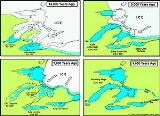
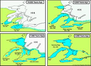
The lake retreats in stages
Two later stages of Lake Maumee, (called the "Lowest" and the "Middle," in that order) had lower water levels because the retreating ice exposed an outlet lower than the Wabash-Erie Channel. The Lowest Maumee (elevation: about 760 ft (232 m) ASL) drained westward through the Grand RiverGrand River (Michigan)
The Grand River is the longest river in the U.S. state of Michigan. It runs through the cities of Jackson, Eaton Rapids, Lansing, Grand Rapids, and Grand Haven.-Description:...
in Michigan
Michigan
Michigan is a U.S. state located in the Great Lakes Region of the United States of America. The name Michigan is the French form of the Ojibwa word mishigamaa, meaning "large water" or "large lake"....
and into Glacial Lake Chicago
Lake Chicago
This article is about the prehistoric lake, For other geographic features with this name, see ChicagoLake Chicago was a prehistoric proglacial lake that is the ancestor of what is now known as Lake Michigan, one of North America's five Great Lakes....
, an ancestor of present-day Lake Michigan
Lake Michigan
Lake Michigan is one of the five Great Lakes of North America and the only one located entirely within the United States. It is the second largest of the Great Lakes by volume and the third largest by surface area, after Lake Superior and Lake Huron...
. Another advance of the ice blocked that outlet, raising the lake level to about 780 feet (238 m) ASL, the stage known as the Middle Maumee. A new outlet called the "Imlay Outlet" formed that connected with an unobstructed segment of the Grand River farther west. There is enough uncertainty about this sequence that some authorities think that Middle Maumee might have preceded Lowest Maumee.
Fluctuations in water level continued through more stages (Akrona, 695 feet (212 m); Whittlesey, 738 feet (225 m) ASL; Warren and Wayne, 660–685 feet (201–209 m) ASL; and Lundy, 590–640 feet (180–195 m) ASL. This see-saw pattern continued until an eastern outlet opened at Niagara
Niagara River
The Niagara River flows north from Lake Erie to Lake Ontario. It forms part of the border between the Province of Ontario in Canada and New York State in the United States. There are differing theories as to the origin of the name of the river...
, establishing the drainage pattern of modern Lake Erie (569 feet (173 m) ASL). This involved the reversal of drainage in what is now northeastern Indiana
Indiana
Indiana is a US state, admitted to the United States as the 19th on December 11, 1816. It is located in the Midwestern United States and Great Lakes Region. With 6,483,802 residents, the state is ranked 15th in population and 16th in population density. Indiana is ranked 38th in land area and is...
and northwestern Ohio
Ohio
Ohio is a Midwestern state in the United States. The 34th largest state by area in the U.S.,it is the 7th‑most populous with over 11.5 million residents, containing several major American cities and seven metropolitan areas with populations of 500,000 or more.The state's capital is Columbus...
as the Maumee River
Maumee River
The Maumee River is a river in northwestern Ohio and northeastern Indiana in the United States. It is formed at Fort Wayne, Indiana by the confluence of the St. Joseph and St. Marys rivers, and meanders northeastwardly for through an agricultural region of glacial moraines before flowing into the...
outlet developed by capturing streams that formerly drained into the Wabash. The Great Black Swamp
Great Black Swamp
The Great Black Swamp, or simply Black Swamp, was a glacially caused wetland in northwest Ohio, United States, extending into extreme northeastern Indiana, that existed from the end of the Wisconsin glaciation until the late 19th century...
that once occupied much of the land between Sandusky, Ohio
Sandusky, Ohio
Sandusky is a city in the U.S. state of Ohio and the county seat of Erie County. It is located in northern Ohio and is situated on the shores of Lake Erie, almost exactly half-way between Toledo to the west and Cleveland to the east....
, and New Haven, Indiana
New Haven, Indiana
-Demographics:As of the census of 2000, there were 12,406 people, 4,900 households, and 3,415 families residing in the city. The population density was 1,522.0 people per square mile . There were 5,141 housing units at an average density of 630.7 per square mile...
, was a remnant of the bed of Glacial Lake Maumee. Geologists call the former lake bottom the Maumee Lacustrine Plain
Lacustrine plain
Some lakes get filled up by the sediments brought down by the rivers and turn into plains in the course of time. Such plains are called lacustrine plains...
.