

Lake Chicago
Encyclopedia
This article is about the prehistoric lake, For other geographic features with this name, see Chicago
 Lake Chicago was a prehistoric proglacial lake
that is the ancestor of what is now known as Lake Michigan
, one of North America
's five Great Lakes
.
lies in a broad plain which, hundreds of millions of years ago, was a great interior basin covered by warm, shallow seas. These seas covered portions of North America from the Arctic Ocean
to the Gulf of Mexico
. Evidence of these seas are found in the fossil
s of coral
, such as those unearthed in Illinois
quarries
at Stony Island Avenue
, Thornton and McCook Avenues, or at 18th Street and Damen Avenue, all in Chicago. Evidence may also be found in the fossils in the Niagara limestone bedrock found throughout the Chicago area and extending all the way to Niagara, New York
.
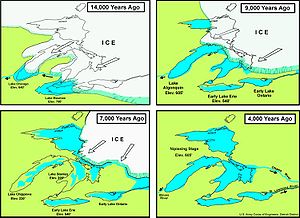
Much later, the polar ice cap
crept four times down across the continent, covering the region with ice to a depth of a mile (1500 m) or more. As the climate changed, the ice melted; and the last great ice flow (the Wisconsin Glacier of the Pleistocene
period, which covered much of northern half of North America) retreated, and an outlet for the melting water developed through the Sag River and the Des Plaines River
Valley around Mt. Forest, Illinois, in the area known as the Palos. Mighty torrents of water poured through those valleys, eventually leaving behind them the prehistoric Lake Chicago, the ancestor of Lake Michigan.
; and south beyond Homewood
and Lansing, Illinois
; completely covering what is now Northwest Indiana
, including the cities of Hammond
and Gary, Indiana
.
As the Wisconsin Glacier continued to retreat, it created new outlets for the water in Lake Chicago, including Niagara Falls
, and the St. Lawrence River. As these outlets were developed, a partial lake capture
occurred and the water level in Lake Chicago began to drop in three observable stages of 15 to 20 feet (5-6 m) each. Eventually even the outlet to the southwest dried up, and the Des Plaines River overflowed into the basin that became Lake Michigan.
, dunes and beach lines—particularly at the southern tip of Lake Michigan, in Indiana—were left behind by each of the three stages of lake level drop. Today, evidence of these vast sand deposits are still clearly visible. Northern Indiana, for example, contains some of the most beautiful beaches found in any of the five Great Lakes; and many of the Chicago area's trails and roads follow some of these ancient beach lines or ridges in the sand spits.
For example, Ridge Road from Homewood, Illinois, through Thornton and Lansing, Illinois
, and then crossing the state border into Munster and Highland, Indiana
, is one; Michigan City Road through Riverdale, Dolton, and Calumet City, Illinois, is another; LaGrange Road is another; Riverside Drive in Riverside; Ridgeland Avenue in Oak Park, or Grosse Point Road, Carpenter Road, and Ridge Avenue {The Rosehill Spit} in the Rogers Park/West Ridge neighborhood of Chicago, north of Devon Avenue and continuing north through Evanston, Illinois, are some others. Blue Island, Illinois
, and Stony Island
were, literally, islands left behind as Lake Chicago's water level fell.
Chicago (disambiguation)
Chicago, Illinois is the third largest city in the United States of America.Chicago may also refer to:-California:* Chicago Park, California, an unincorporated community in Nevada County...
Proglacial lake
In geology, a proglacial lake is a lake formed either by the damming action of a moraine or ice dam during the retreat of a melting glacier, or by meltwater trapped against an ice sheet due to isostatic depression of the crust around the ice...
that is the ancestor of what is now known as Lake Michigan
Lake Michigan
Lake Michigan is one of the five Great Lakes of North America and the only one located entirely within the United States. It is the second largest of the Great Lakes by volume and the third largest by surface area, after Lake Superior and Lake Huron...
, one of North America
North America
North America is a continent wholly within the Northern Hemisphere and almost wholly within the Western Hemisphere. It is also considered a northern subcontinent of the Americas...
's five Great Lakes
Great Lakes
The Great Lakes are a collection of freshwater lakes located in northeastern North America, on the Canada – United States border. Consisting of Lakes Superior, Michigan, Huron, Erie, and Ontario, they form the largest group of freshwater lakes on Earth by total surface, coming in second by volume...
.
Origin
The city of ChicagoChicago
Chicago is the largest city in the US state of Illinois. With nearly 2.7 million residents, it is the most populous city in the Midwestern United States and the third most populous in the US, after New York City and Los Angeles...
lies in a broad plain which, hundreds of millions of years ago, was a great interior basin covered by warm, shallow seas. These seas covered portions of North America from the Arctic Ocean
Arctic Ocean
The Arctic Ocean, located in the Northern Hemisphere and mostly in the Arctic north polar region, is the smallest and shallowest of the world's five major oceanic divisions...
to the Gulf of Mexico
Gulf of Mexico
The Gulf of Mexico is a partially landlocked ocean basin largely surrounded by the North American continent and the island of Cuba. It is bounded on the northeast, north and northwest by the Gulf Coast of the United States, on the southwest and south by Mexico, and on the southeast by Cuba. In...
. Evidence of these seas are found in the fossil
Fossil
Fossils are the preserved remains or traces of animals , plants, and other organisms from the remote past...
s of coral
Coral
Corals are marine animals in class Anthozoa of phylum Cnidaria typically living in compact colonies of many identical individual "polyps". The group includes the important reef builders that inhabit tropical oceans and secrete calcium carbonate to form a hard skeleton.A coral "head" is a colony of...
, such as those unearthed in Illinois
Illinois
Illinois is the fifth-most populous state of the United States of America, and is often noted for being a microcosm of the entire country. With Chicago in the northeast, small industrial cities and great agricultural productivity in central and northern Illinois, and natural resources like coal,...
quarries
Quarries
Quarries - The "Royal Quarries" — not found in Scripture — is the namegiven to the vast caverns stretching far underneath the northern hill, Bezetha, on which Jerusalem is built. Out of these mammoth caverns stones, a hard limestone, have been quarried in ancient times for the buildings in the...
at Stony Island Avenue
Stony Island Avenue
Stony Island Avenue is a major thoroughfare on South Side of the city of Chicago, designated 1600 East in Chicago's street numbering system. It runs from 56th Street south to the Calumet River. Stony Island Avenue continues sporadically south of the Calumet in the southern suburbs, running...
, Thornton and McCook Avenues, or at 18th Street and Damen Avenue, all in Chicago. Evidence may also be found in the fossils in the Niagara limestone bedrock found throughout the Chicago area and extending all the way to Niagara, New York
Niagara, New York
Niagara is a town in Niagara County, New York, United States. As of the 2010 census, the town had a total population of 8,378. The town is named after the famous waterfall Niagara Falls....
.
Much later, the polar ice cap
Polar ice cap
A polar ice cap is a high latitude region of a planet or natural satellite that is covered in ice. There are no requirements with respect to size or composition for a body of ice to be termed a polar ice cap, nor any geological requirement for it to be over land; only that it must be a body of...
crept four times down across the continent, covering the region with ice to a depth of a mile (1500 m) or more. As the climate changed, the ice melted; and the last great ice flow (the Wisconsin Glacier of the Pleistocene
Pleistocene
The Pleistocene is the epoch from 2,588,000 to 11,700 years BP that spans the world's recent period of repeated glaciations. The name pleistocene is derived from the Greek and ....
period, which covered much of northern half of North America) retreated, and an outlet for the melting water developed through the Sag River and the Des Plaines River
Des Plaines River
The Des Plaines River is a river that flows southward for through southern Wisconsin and northern Illinois in the U.S. Midwest, eventually meeting the Kankakee River west of Channahon to form the Illinois River, a tributary of the Mississippi River....
Valley around Mt. Forest, Illinois, in the area known as the Palos. Mighty torrents of water poured through those valleys, eventually leaving behind them the prehistoric Lake Chicago, the ancestor of Lake Michigan.
Size
Somewhat larger than Lake Michigan, Lake Chicago extended west to present day La Grange, IllinoisLa Grange, Illinois
La Grange, a suburb of Chicago, is a village in Cook County, in the U.S. state of Illinois. The population was 15,608 at the 2000 census.-History:...
; and south beyond Homewood
Homewood, Illinois
Homewood is a village in Cook County, Illinois, United States. The population was 19,543 at the 2000 census. Homewood is a sister city to Homewood, Alabama.- Geography :...
and Lansing, Illinois
Lansing, Illinois
Lansing is a village in Cook County, Illinois, USA. Lansing is a southern suburb of Chicago. The population was 28,332 at the 2000 census.-Geography:...
; completely covering what is now Northwest Indiana
Northwest Indiana
Northwest Indiana, also known as the South Shore and The Calumet Region or simply The Region, comprises Lake, Porter, LaPorte, Newton and Jasper counties in Indiana. This region neighbors Lake Michigan and is part of the Chicago metropolitan area...
, including the cities of Hammond
Hammond
-Canada:*Hammond River, a small river in New Brunswick*Upper Hammonds Plains, Nova Scotia*Hammond, Ontario, Canada, now Clarence-Rockland, Ontario.*Port Hammond, British Columbia, also known as Hammond or Hammond's Landing-United States of America:...
and Gary, Indiana
Gary, Indiana
Gary is a city in Lake County, Indiana, United States. The city is in the southeastern portion of the Chicago metropolitan area and is 25 miles from downtown Chicago. The population is 80,294 at the 2010 census, making it the seventh-largest city in the state. It borders Lake Michigan and is known...
.
As the Wisconsin Glacier continued to retreat, it created new outlets for the water in Lake Chicago, including Niagara Falls
Niagara Falls
The Niagara Falls, located on the Niagara River draining Lake Erie into Lake Ontario, is the collective name for the Horseshoe Falls and the adjacent American Falls along with the comparatively small Bridal Veil Falls, which combined form the highest flow rate of any waterfalls in the world and has...
, and the St. Lawrence River. As these outlets were developed, a partial lake capture
Lake capture
In geology, lake capture is the process of capture of the waters collected in a lake by a neighbor river basin.The occurrence of a lake capture is mainly controlled by the water balance at the lake's basin and the changes in topography due to erosion, sedimentation, and tectonism...
occurred and the water level in Lake Chicago began to drop in three observable stages of 15 to 20 feet (5-6 m) each. Eventually even the outlet to the southwest dried up, and the Des Plaines River overflowed into the basin that became Lake Michigan.
Today
Vast amounts of sand in spitsSpit (landform)
A spit or sandspit is a deposition landform found off coasts. At one end, spits connect to land, and extend into the sea. A spit is a type of bar or beach that develops where a re-entrant occurs, such as at cove's headlands, by the process of longshore drift...
, dunes and beach lines—particularly at the southern tip of Lake Michigan, in Indiana—were left behind by each of the three stages of lake level drop. Today, evidence of these vast sand deposits are still clearly visible. Northern Indiana, for example, contains some of the most beautiful beaches found in any of the five Great Lakes; and many of the Chicago area's trails and roads follow some of these ancient beach lines or ridges in the sand spits.
For example, Ridge Road from Homewood, Illinois, through Thornton and Lansing, Illinois
Lansing, Illinois
Lansing is a village in Cook County, Illinois, USA. Lansing is a southern suburb of Chicago. The population was 28,332 at the 2000 census.-Geography:...
, and then crossing the state border into Munster and Highland, Indiana
Highland, Indiana
Highland is the name of some places in the U.S. state of Indiana:*Highland, Lake County, Indiana*Highland, Vanderburgh County, Indiana*Highland, Vermillion County, Indiana...
, is one; Michigan City Road through Riverdale, Dolton, and Calumet City, Illinois, is another; LaGrange Road is another; Riverside Drive in Riverside; Ridgeland Avenue in Oak Park, or Grosse Point Road, Carpenter Road, and Ridge Avenue {The Rosehill Spit} in the Rogers Park/West Ridge neighborhood of Chicago, north of Devon Avenue and continuing north through Evanston, Illinois, are some others. Blue Island, Illinois
Blue Island, Illinois
Blue Island is a city in Cook County, Illinois. The population was 22,556 at the 2010 census. Blue Island was established in the 1830s as a way station for settlers traveling on the Vincennes Trace, and the settlement prospered because it was conveniently situated a day's journey outside of Chicago...
, and Stony Island
Stony Island Avenue
Stony Island Avenue is a major thoroughfare on South Side of the city of Chicago, designated 1600 East in Chicago's street numbering system. It runs from 56th Street south to the Calumet River. Stony Island Avenue continues sporadically south of the Calumet in the southern suburbs, running...
were, literally, islands left behind as Lake Chicago's water level fell.
External links
- Killey, Myrna M. 1998. Illinois' Ice Age Legacy. Illinois State Geological Survey GeoScience Education Series 14. 66 pages.
- Willman, H.B. 1971. Summary of the Geology of the Chicago Area. Illinois State Geological Survey, Urbana, IL. Circular 460. 77 pages.
- Forest Preserve District of Cook County
- Oak Park - Ancient Lake Chicago & Continental Divide