

Ghost towns in Saskatchewan
Encyclopedia
The following is a list of communities that no longer exist or former Village
s/Town
s that have become unincorporated
hamlets
in the province
of Saskatchewan
, Canada
.
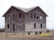
Ghost town
s are town
s that once had a considerable population, that have since dwindled in numbers causing some or all its business to close, either due to the rerouting of a highway
, train tracks being pulled, or exhaustion of a natural resource
. One of the more famous stories of Saskatchewan ghost towns arose around Uranium City
which was close to achieving city status and utterly collapsed upon the closure of the Eldorado mine
and the mass exodus of its population.
Initially travel began by horse and wagon or ox
and cart along trails which generally followed animal trails across the North West Territories
. Railways would not build across the western frontier
without settlement as it would be too costly to provide train service across a barren wilderness. The Clifford Sifton immigration policy encouraged settlers to arrive. Western settlement began and immigration encroached across the Manitoba border into the North West Territories later to become the Province
of Saskatchewan in 1905. Rail stations, post offices, schools and towns sprang up approximately 6 miles (9.7 km) to 10 miles (16.1 km) apart to accommodate ox and cart as well as horse and wagon travel. As travel evolved to automobiles, there was no longer a need for centers this close together. In the 1940s when the highway became more popular, and the rail branch lines started to close down, saw the demise of sidings and villages located on the rail line but not on the highway. In the late 1950s and 1960s when highways were straightened and developed from gravel to asphalt and oil surface highways many of the bypassed towns and villages folded. Businesses set up shop in towns on the new straightened highway, and children could be bussed to composite schools in the larger centers. The following placenames may exist only as commemorative road names which intersect the current highways and have disappeared altogether or they may be unincorporated areas of the RM
such as Floral
, the birthplace of Gordie Howe
. Floral would be currently located off the Yellowhead highway
for example but it was on Provincial Highway 5 when the road was on the square. Floral currently is demarked by an old church at the Floral Cemetery, and the Floral one room school is now the community hall for meetings and socials. The only remembrance of Floral is a road named Floral road. The road traveled on the 'square' connecting many small country towns was a different one from the highway of today connecting larger urban centers.
A rural municipality
, often abbreviated RM, is a form of municipality
consisting of an elected reeve for the elected head along with aldermen or Councillor
s of a rural municipality, performing a similar role to the mayor
of a village, town or city. An RM may have its office in a town or village, which has its own separate and distinct civic administration, but the RM administers the rural affairs of a large land area including unincorporated areas or ghost towns. The RM administers the remaining population of the ghost town providing any needed civic infrastructure, safety, health, educational, or tourism affairs. Localities with small populations are enumerated in census taking by Statistics Canada as a population belonging to the RM. For instance Churchbridge No. 211
includes the localities of Beresina and the Melville Airport.
Village
A village is a clustered human settlement or community, larger than a hamlet with the population ranging from a few hundred to a few thousand , Though often located in rural areas, the term urban village is also applied to certain urban neighbourhoods, such as the West Village in Manhattan, New...
s/Town
Town
A town is a human settlement larger than a village but smaller than a city. The size a settlement must be in order to be called a "town" varies considerably in different parts of the world, so that, for example, many American "small towns" seem to British people to be no more than villages, while...
s that have become unincorporated
Unincorporated
Unincorporated may refer to:* Unincorporated area, land not governed by a local municipality* Unincorporated entity, a type of organization* Unincorporated territories of the United States, territories under U.S. jurisdiction, to which Congress has determined that only select parts of the U.S...
hamlets
Hamlet (place)
A hamlet is usually a rural settlement which is too small to be considered a village, though sometimes the word is used for a different sort of community. Historically, when a hamlet became large enough to justify building a church, it was then classified as a village...
in the province
Province
A province is a territorial unit, almost always an administrative division, within a country or state.-Etymology:The English word "province" is attested since about 1330 and derives from the 13th-century Old French "province," which itself comes from the Latin word "provincia," which referred to...
of Saskatchewan
Saskatchewan
Saskatchewan is a prairie province in Canada, which has an area of . Saskatchewan is bordered on the west by Alberta, on the north by the Northwest Territories, on the east by Manitoba, and on the south by the U.S. states of Montana and North Dakota....
, Canada
Canada
Canada is a North American country consisting of ten provinces and three territories. Located in the northern part of the continent, it extends from the Atlantic Ocean in the east to the Pacific Ocean in the west, and northward into the Arctic Ocean...
.
Ghost town
Ghost town
A ghost town is an abandoned town or city. A town often becomes a ghost town because the economic activity that supported it has failed, or due to natural or human-caused disasters such as floods, government actions, uncontrolled lawlessness, war, or nuclear disasters...
s are town
Town
A town is a human settlement larger than a village but smaller than a city. The size a settlement must be in order to be called a "town" varies considerably in different parts of the world, so that, for example, many American "small towns" seem to British people to be no more than villages, while...
s that once had a considerable population, that have since dwindled in numbers causing some or all its business to close, either due to the rerouting of a highway
Highway
A highway is any public road. In American English, the term is common and almost always designates major roads. In British English, the term designates any road open to the public. Any interconnected set of highways can be variously referred to as a "highway system", a "highway network", or a...
, train tracks being pulled, or exhaustion of a natural resource
Natural resource
Natural resources occur naturally within environments that exist relatively undisturbed by mankind, in a natural form. A natural resource is often characterized by amounts of biodiversity and geodiversity existent in various ecosystems....
. One of the more famous stories of Saskatchewan ghost towns arose around Uranium City
Uranium City, Saskatchewan
Uranium City is a settlement in northwestern Saskatchewan, Canada. It is on the northern shores of Lake Athabasca near the border of the Northwest Territories. It is above sea level. The settlement is northwest of Prince Albert, 760 km northeast of Edmonton and south of the Northwest...
which was close to achieving city status and utterly collapsed upon the closure of the Eldorado mine
Eldorado Mining and Refining Limited
The Eldorado Mining and Refining Limited company was originally organized in 1927 as Eldorado Gold Mines Limited to develop a gold mine in Manitoba. Its president Gilbert LaBine later found radioactive deposits at Great Bear Lake, Northwest Territories in 1930, which led to the development of the...
and the mass exodus of its population.
Initially travel began by horse and wagon or ox
Ox
An ox , also known as a bullock in Australia, New Zealand and India, is a bovine trained as a draft animal. Oxen are commonly castrated adult male cattle; castration makes the animals more tractable...
and cart along trails which generally followed animal trails across the North West Territories
Territorial evolution of Canada
The federation of Canada was created in 1867 when three colonies of British North America were united. One of these colonies split into two new provinces, three other colonies joined later...
. Railways would not build across the western frontier
Western Canada
Western Canada, also referred to as the Western provinces and commonly as the West, is a region of Canada that includes the four provinces west of the province of Ontario.- Provinces :...
without settlement as it would be too costly to provide train service across a barren wilderness. The Clifford Sifton immigration policy encouraged settlers to arrive. Western settlement began and immigration encroached across the Manitoba border into the North West Territories later to become the Province
Province
A province is a territorial unit, almost always an administrative division, within a country or state.-Etymology:The English word "province" is attested since about 1330 and derives from the 13th-century Old French "province," which itself comes from the Latin word "provincia," which referred to...
of Saskatchewan in 1905. Rail stations, post offices, schools and towns sprang up approximately 6 miles (9.7 km) to 10 miles (16.1 km) apart to accommodate ox and cart as well as horse and wagon travel. As travel evolved to automobiles, there was no longer a need for centers this close together. In the 1940s when the highway became more popular, and the rail branch lines started to close down, saw the demise of sidings and villages located on the rail line but not on the highway. In the late 1950s and 1960s when highways were straightened and developed from gravel to asphalt and oil surface highways many of the bypassed towns and villages folded. Businesses set up shop in towns on the new straightened highway, and children could be bussed to composite schools in the larger centers. The following placenames may exist only as commemorative road names which intersect the current highways and have disappeared altogether or they may be unincorporated areas of the RM
Rural municipality
A rural municipality, often abbreviated RM, is a form of municipality in the Canadian provinces of Manitoba and Saskatchewan, perhaps best comparable to counties or townships in the western United States...
such as Floral
Floral, Saskatchewan
Floral, Saskatchewan is a small unincorporated village located in the southeast city limits of Saskatoon, just east of Highway 16 off the Floral Road exit in the province of Saskatchewan, Canada. Floral is part of rural municipality Corman Park No. 344, Saskatchewan...
, the birthplace of Gordie Howe
Gordie Howe
Gordon "Gordie" Howe, OC is a Canadian retired professional ice hockey player who played for the Detroit Red Wings and Hartford Whalers of the National Hockey League , and the Houston Aeros and New England Whalers in the World Hockey Association . Howe is often referred to as Mr...
. Floral would be currently located off the Yellowhead highway
Saskatchewan Highway 16
Highway 16 is a provincial paved highway in the Canadian province of Saskatchewan. It is the Saskatchewan section of the Yellowhead Highway, and also the Trans-Canada Highway Yellowhead section. The main purpose of this highway is to connect Saskatchewan with Canadian cities such as Edmonton and...
for example but it was on Provincial Highway 5 when the road was on the square. Floral currently is demarked by an old church at the Floral Cemetery, and the Floral one room school is now the community hall for meetings and socials. The only remembrance of Floral is a road named Floral road. The road traveled on the 'square' connecting many small country towns was a different one from the highway of today connecting larger urban centers.
A rural municipality
Rural municipality
A rural municipality, often abbreviated RM, is a form of municipality in the Canadian provinces of Manitoba and Saskatchewan, perhaps best comparable to counties or townships in the western United States...
, often abbreviated RM, is a form of municipality
Municipality
A municipality is essentially an urban administrative division having corporate status and usually powers of self-government. It can also be used to mean the governing body of a municipality. A municipality is a general-purpose administrative subdivision, as opposed to a special-purpose district...
consisting of an elected reeve for the elected head along with aldermen or Councillor
Councillor
A councillor or councilor is a member of a local government council, such as a city council.Often in the United States, the title is councilman or councilwoman.-United Kingdom:...
s of a rural municipality, performing a similar role to the mayor
Mayor
In many countries, a Mayor is the highest ranking officer in the municipal government of a town or a large urban city....
of a village, town or city. An RM may have its office in a town or village, which has its own separate and distinct civic administration, but the RM administers the rural affairs of a large land area including unincorporated areas or ghost towns. The RM administers the remaining population of the ghost town providing any needed civic infrastructure, safety, health, educational, or tourism affairs. Localities with small populations are enumerated in census taking by Statistics Canada as a population belonging to the RM. For instance Churchbridge No. 211
Churchbridge No. 211, Saskatchewan
This article is about the rural municipality in Canada. For other places with the same name, see ChurchbridgeChurchbridge No. 211, Saskatchewan, is a rural municipality of 679 rural residents in the east centralpart of Saskatchewan, Canada. The RM was incorporated January 1, 1913...
includes the localities of Beresina and the Melville Airport.
List of ghost towns
| Town Name | Rural Municipality |
Peak year | Peak Population | Location |
|---|---|---|---|---|
| Arena Arena, Saskatchewan Arena, Saskatchewan was once a hamlet in the southwestern part of the province of Saskatchewan, Canada.-External links:*********-Footnotes:... |
Frontier No. 19 Frontier No. 19, Saskatchewan Frontier No. 19 is a rural municipality in the Canadian province of Saskatchewan, located in the southwestern part of the province south of the town of Eastend.-Demographics:... |
|||
| Baildon | Baildon No. 131 Baildon No. 131, Saskatchewan Baildon No. 131 is a rural municipality in the Canadian province of Saskatchewan, located in the south-central area of the province, south of Moose Jaw.-Statistics:According to the Canada 2001 Census:*Population: 548*Dwellings: 205*Area : 846.21... |
|||
| Bateman Bateman, Saskatchewan Bateman was a small hamlet in the southwest region of Saskatchewan, Canada situated 26 kilometers north of the Red Coat Trail, and was named after Jim Bateman the first settler to come to the area with his family in 1908.... |
Gravelbourg No. 104 Gravelbourg No. 104, Saskatchewan This article is about the rural municipality in Canada. For the Saskatchewan town, see Gravelbourg, SaskatchewanGravelbourg No. 104 is a rural municipality of 329 rural residents in the southwestern part of Saskatchewan, Canada. The RM was incorporated December 9, 1912. Whereas, the Local... |
1920s | 300 | |
| Battrum Battrum, Saskatchewan Battrum is a hamlet in Saskatchewan.... |
Saskatchewan Saskatchewan Saskatchewan is a prairie province in Canada, which has an area of . Saskatchewan is bordered on the west by Alberta, on the north by the Northwest Territories, on the east by Manitoba, and on the south by the U.S. states of Montana and North Dakota.... |
|||
| Bayard Bayard, Saskatchewan Bayard, Saskatchewan is a hamlet located along highway 715, and is approximately 4 km Southwest of Claybank. Area was populated by Germanic immigrants primarily from Bukovina during the late 19th and early 20th Century.... |
Terrell No. 101 | |||
| Bents | Saskatchewan Saskatchewan Saskatchewan is a prairie province in Canada, which has an area of . Saskatchewan is bordered on the west by Alberta, on the north by the Northwest Territories, on the east by Manitoba, and on the south by the U.S. states of Montana and North Dakota.... |
51.816°N 107.734°W | ||
| Birch Creek | Emerald No. 277 Emerald No. 277, Saskatchewan Emerald No. 277 is a rural municipality in the Canadian province of Saskatchewan, located in the Census Division 10. The seat of the municipality is located in the Hamlet of Wishart.-Demographics:... |
1910s | Sec.10, Twp.30, R.14, W2 | |
| Blewett | Saskatchewan Saskatchewan Saskatchewan is a prairie province in Canada, which has an area of . Saskatchewan is bordered on the west by Alberta, on the north by the Northwest Territories, on the east by Manitoba, and on the south by the U.S. states of Montana and North Dakota.... |
|||
| Bounty | Fertile Valley No. 286 | 200 | ||
| Breeze | Saskatchewan Saskatchewan Saskatchewan is a prairie province in Canada, which has an area of . Saskatchewan is bordered on the west by Alberta, on the north by the Northwest Territories, on the east by Manitoba, and on the south by the U.S. states of Montana and North Dakota.... |
|||
| Bresaylor Bresaylor, Saskatchewan Bresaylor is a hamlet in Saskatchewan.... |
Saskatchewan Saskatchewan Saskatchewan is a prairie province in Canada, which has an area of . Saskatchewan is bordered on the west by Alberta, on the north by the Northwest Territories, on the east by Manitoba, and on the south by the U.S. states of Montana and North Dakota.... |
|||
| Bromhead | Saskatchewan Saskatchewan Saskatchewan is a prairie province in Canada, which has an area of . Saskatchewan is bordered on the west by Alberta, on the north by the Northwest Territories, on the east by Manitoba, and on the south by the U.S. states of Montana and North Dakota.... |
|||
| Brooking | Saskatchewan Saskatchewan Saskatchewan is a prairie province in Canada, which has an area of . Saskatchewan is bordered on the west by Alberta, on the north by the Northwest Territories, on the east by Manitoba, and on the south by the U.S. states of Montana and North Dakota.... |
|||
| Bryant | Benson No. 35 Benson No. 35, Saskatchewan Benson No. 35 is a rural municipality in south-east Saskatchewan, Canada encompassing 836.39 square kilometers in area. The rural municipality has within its boundaries the communities of Benson and Bryant, Saskatchewan. The rural municipality maintains offices in the community of Benson... |
|||
| Cactus Lake Cactus Lake, Saskatchewan Cactus Lake is a small settlement that is located about 8 kilometers from the Alberta-Saskatchewan border. Cactus Lake was once a large town, but due to the growing oil industry, fell to a population of only 2 when neighboring towns began to grow.... |
Heart's Hill No. 352 Heart's Hill No. 352, Saskatchewan Heart's Hill No. 352, Saskatchewan was incorporated November 15, 1910. It is a rural municipality in west-central Saskatchewan, Canada on the Alberta - Saskatchewan border. Heart's Hill No. 352 operates from Box 458, Luseland, SK S0L 2A0. Heart's Hill No. 352 encompasses the placename of Cactus... |
|||
| Chandler | Saskatchewan Saskatchewan Saskatchewan is a prairie province in Canada, which has an area of . Saskatchewan is bordered on the west by Alberta, on the north by the Northwest Territories, on the east by Manitoba, and on the south by the U.S. states of Montana and North Dakota.... |
|||
| Clansman | Saskatchewan Saskatchewan Saskatchewan is a prairie province in Canada, which has an area of . Saskatchewan is bordered on the west by Alberta, on the north by the Northwest Territories, on the east by Manitoba, and on the south by the U.S. states of Montana and North Dakota.... |
|||
| Claydon Claydon, Saskatchewan - See also :* List of places with fewer than ten residents* List of communities in Saskatchewan* Hamlets of Saskatchewan* List of ghost towns in Canada* Ghost towns in Saskatchewan-External links:... |
Saskatchewan Saskatchewan Saskatchewan is a prairie province in Canada, which has an area of . Saskatchewan is bordered on the west by Alberta, on the north by the Northwest Territories, on the east by Manitoba, and on the south by the U.S. states of Montana and North Dakota.... |
|||
| Clearfield | Saskatchewan Saskatchewan Saskatchewan is a prairie province in Canada, which has an area of . Saskatchewan is bordered on the west by Alberta, on the north by the Northwest Territories, on the east by Manitoba, and on the south by the U.S. states of Montana and North Dakota.... |
|||
| Coalfields | Saskatchewan Saskatchewan Saskatchewan is a prairie province in Canada, which has an area of . Saskatchewan is bordered on the west by Alberta, on the north by the Northwest Territories, on the east by Manitoba, and on the south by the U.S. states of Montana and North Dakota.... |
|||
| Colgate | Lomond No. 37 Lomond No. 37, Saskatchewan Lomond No. 37 is a rural municipality in south-eastern Saskatchewan, Canada south of Weyburn.The two principal industries in Lomond are agriculture and petroleum production.... |
|||
| Court Court, Saskatchewan Court is an unincorporated hamlet in Antelope Park Rural Municipality No. 322, Saskatchewan, Canada. The hamlet is approximately 50 km west of the Town of Kerrobert at the intersection of Highway 51 and Range road 282. The Canadian Pacific Railway played a big role in the towns economy when it... |
Saskatchewan Saskatchewan Saskatchewan is a prairie province in Canada, which has an area of . Saskatchewan is bordered on the west by Alberta, on the north by the Northwest Territories, on the east by Manitoba, and on the south by the U.S. states of Montana and North Dakota.... |
|||
| Crichton | Wise Creek No. 77 Wise Creek No. 77, Saskatchewan Wise Creek No. 77 is a rural municipality in the Canadian province of Saskatchewan, located in the southwestern part of the province near Eastend.-Statistics:According to the Canada 2001 Census:*Population: 257*Dwellings: 91*Area : 843.84... |
|||
| Cullen | Saskatchewan Saskatchewan Saskatchewan is a prairie province in Canada, which has an area of . Saskatchewan is bordered on the west by Alberta, on the north by the Northwest Territories, on the east by Manitoba, and on the south by the U.S. states of Montana and North Dakota.... |
|||
| Cummings | Maple Creek No. 111 Maple Creek No. 111, Saskatchewan This article is about the rural municipality in Canada. For other places with the same name, see Maple Creek Maple Creek No. 111 is a rural municipality of 1,167 rural residents in the southwestern part of Saskatchewan, Canada. The main economic industry is ranching. The RM was incorporated... |
|||
| Divide Divide, Saskatchewan -External links:*******... |
Reno No. 51 Reno No. 51, Saskatchewan Reno No. 51 is a rural municipality in the Canadian province of Saskatchewan, located in the Census Division 4, just north of the USA border, and east of the Alberta border, in the southwestern corner of the province... |
|||
| Diana | Saskatchewan Saskatchewan Saskatchewan is a prairie province in Canada, which has an area of . Saskatchewan is bordered on the west by Alberta, on the north by the Northwest Territories, on the east by Manitoba, and on the south by the U.S. states of Montana and North Dakota.... |
|||
| Dneiper | Saskatchewan Saskatchewan Saskatchewan is a prairie province in Canada, which has an area of . Saskatchewan is bordered on the west by Alberta, on the north by the Northwest Territories, on the east by Manitoba, and on the south by the U.S. states of Montana and North Dakota.... |
|||
| Dunning | Saskatchewan Saskatchewan Saskatchewan is a prairie province in Canada, which has an area of . Saskatchewan is bordered on the west by Alberta, on the north by the Northwest Territories, on the east by Manitoba, and on the south by the U.S. states of Montana and North Dakota.... |
|||
| Dummer | Caledonia No. 99 Caledonia No. 99, Saskatchewan Caledonia No. 99 is a rural municipality in south-eastern Saskatchewan, Canada encompassing 845.68 square kilometers in area. The rural municipality maintains it's office in Milestone, Saskatchewan . The rural municipality include the hamlets of Parry and Dummer... |
|||
| Elcott | Saskatchewan Saskatchewan Saskatchewan is a prairie province in Canada, which has an area of . Saskatchewan is bordered on the west by Alberta, on the north by the Northwest Territories, on the east by Manitoba, and on the south by the U.S. states of Montana and North Dakota.... |
|||
| Elswick | Saskatchewan Saskatchewan Saskatchewan is a prairie province in Canada, which has an area of . Saskatchewan is bordered on the west by Alberta, on the north by the Northwest Territories, on the east by Manitoba, and on the south by the U.S. states of Montana and North Dakota.... |
|||
| Estuary | Deer Forks No. 232 Deer Forks No. 232, Saskatchewan Deer Forks No. 232 is a rural municipality in the Canadian province of Saskatchewan, located in the Census Division 4, just north of the USA border, and east of the Alberta border, in the southwestern corner of the province... |
1914 | 800 | |
| Expance | Lake Johnson No. 102 | |||
| Flintoft | Stonehenge No. 73 Stonehenge No. 73, Saskatchewan Stonehenge No. 73 is a rural municipality in south-central Saskatchewan, Canada. It is located in Division No. 2.-Statistics:-Communities:... |
|||
| Floral Floral, Saskatchewan Floral, Saskatchewan is a small unincorporated village located in the southeast city limits of Saskatoon, just east of Highway 16 off the Floral Road exit in the province of Saskatchewan, Canada. Floral is part of rural municipality Corman Park No. 344, Saskatchewan... |
City of Saskatoon | |||
| Forget Forget, Saskatchewan - See also :* List of communities in Saskatchewan* Villages of Saskatchewan-External links:********-Further reading:Abley, Mark Beyond Forget: Rediscovering the Prairies, Canada: Douglas & McIntyre Ltd., reprinted 1988 by Chatto & Windus Ltd., London, UK, ISBN 0-7011-3296-5. Pages 10–14 focus on... |
Tecumseh No. 65 Tecumseh No. 65, Saskatchewan This article is about the rural municipality in Canada. For other places with the same name, see Tecumseh Tecumseh No. 65 is a rural municipality of 270 rural residents in the southeastern part of Saskatchewan, Canada. The RM was incorporated December 13, 1909... |
|||
| Forward | Norton No. 69 Norton No. 69, Saskatchewan Norton No. 69 is a rural municipality in south-eastern Saskatchewan, Canada encompassing 844.80 square kilometers in area. The rural municipality maintains it's office in Pangman, Saskatchewan . Khedive is an unincorporated settlement within the rural municipality... |
|||
| Froude | Griffin No. 66 Griffin No. 66, Saskatchewan The Rural Municipality of Griffin No. 66, Saskatchewan was originally called Hastings and is now named Griffin as of January 30, 1910. The original founding date of Hastings was December 13, 1909 -Statistics:According to the Canada 2001 Census:... |
|||
| Fusilier Fusilier, Saskatchewan Fusilier is a unincorporated hamlet in Antelope Park Rural Municipality No. 322, Saskatchewan, Canada. The hamlet is approximately 30 km west of the Town of Kerrobert at the intersection of Highway 51 and Highway 317... |
Antelope Park No. 322 Antelope Park No. 322, Saskatchewan Antelope Park No. 322 is a rural municipality in the Canadian province of Saskatchewan, located in the Census Division 13. The municipality was established on December 11, 1911 in west-central Saskatchewan, Canada on the Alberta - Saskatchewan border. Antelope Park No... |
1920s | 125 | |
| Garwood | Saskatchewan Saskatchewan Saskatchewan is a prairie province in Canada, which has an area of . Saskatchewan is bordered on the west by Alberta, on the north by the Northwest Territories, on the east by Manitoba, and on the south by the U.S. states of Montana and North Dakota.... |
|||
| Gibbs | Longlaketon No. 219 Longlaketon No. 219, Saskatchewan Longlaketon No. 219 is a rural municipality in Saskatchewan, Canada encompassing 1,024.61 square kilometers in area. The rural municipality maintains its office in Earl Grey, Saskatchewan . The rural municipality in conjunction with the provincial government is in charge of maintenance of... |
|||
| Girvin Girvin, Saskatchewan -Girvin Pump house:Built in the 1906, it is known as the only pump house in Saskatchewan making it a Provincial historic site of Saskatchewan on September 14, 1994, the pump house was constructed to provide access to water for horses used to haul grain to Girvin.... |
Arm River No. 252 Arm River No. 252, Saskatchewan Arm River No. 252 is a rural municipality in central Saskatchewan, Canada along Highway 11 between Saskatoon and Regina. It is located in Division No. 15. Arm River No. 252 was incorporated as Girvin on December 1, 1909, the name changing to Arm River on June 29, 1912... |
|||
| Glen Bain | Glen Bain No. 105 Glen Bain No. 105, Saskatchewan Glen Bain No. 105 is a rural municipality in the Canadian province of Saskatchewan, located in the Census Division 3, in the southcentral region of the province. The seat of the municipality is located in the village of Glen Bain.-Demographics:... |
|||
| Goodwater Goodwater, Saskatchewan - See also :* List of communities in Saskatchewan* Villages of Saskatchewan-External links:*******-Footnotes:... |
Lomond No. 37 Lomond No. 37, Saskatchewan Lomond No. 37 is a rural municipality in south-eastern Saskatchewan, Canada south of Weyburn.The two principal industries in Lomond are agriculture and petroleum production.... |
N 49.400055 W 103.7010298 | ||
| Gouverneur | Auvergne No. 76 Auvergne No. 76, Saskatchewan Auvergne No. 76 is a rural municipality in Saskatchewan, Canada encompassing 853.40 square kilometers in area. The rural municipality in conjunction with the provincial government is in charge of maintenance of highways in its area... |
|||
| Govenlock Govenlock, Saskatchewan Govenlock was once a small village of 151 in Reno Rural Municipality No. 51, Saskatchewan, Canada. The former townsite of Govenlock is located on Highway 13 also known as the historic Red Coat Trail, about 15 km east of the Alberta-Saskatchewan border... |
Reno No. 51 Reno No. 51, Saskatchewan Reno No. 51 is a rural municipality in the Canadian province of Saskatchewan, located in the Census Division 4, just north of the USA border, and east of the Alberta border, in the southwestern corner of the province... |
1920s | 200 | |
| Grassdale | Weyburn No. 67 Weyburn No. 67, Saskatchewan Weyburn No. 67 is a rural municipality in south-eastern Saskatchewan, Canada encompassing 811.70 square kilometers in area. The rural municipality maintains its office in Weyburn, Saskatchewan . Located within the area of the rural municipality are the communities of North Weyburn, McTaggart... |
|||
| Halkett | Estavan No. 5 | |||
| Handsworth Handsworth, Saskatchewan Handsworth is a hamlet in Golden West Rural Municipality 95, Saskatchewan, Canada. The hamlet is located about 20km east of the town of Creelman on Highway 701, along a former Canadian Pacific Railway branch line.-External links:... |
Golden West No. 95 Golden West No. 95, Saskatchewan Golden West No. 95 is a rural municipality in south-eastern Saskatchewan, Canada encompassing 790.13 square kilometers in area. The rural municipality maintains it's office in Corning, Saskatchewan. The rural municipality in conjunction with the provincial government is in charge of maintenance... |
|||
| Hatton | Maple Creek No. 111 Maple Creek No. 111, Saskatchewan This article is about the rural municipality in Canada. For other places with the same name, see Maple Creek Maple Creek No. 111 is a rural municipality of 1,167 rural residents in the southwestern part of Saskatchewan, Canada. The main economic industry is ranching. The RM was incorporated... |
|||
| Hearne | Redburn No. 130 Redburn No. 130, Saskatchewan Redburn No. 130 is a rural municipality in the Canadian province of Saskatchewan, located in SARM Division 2 which is located in Census Division 6. Southeast of the city of Moose Jaw in the south central region of the province. The seat of the municipality is Rouleau.-Demographics:In 2006, the... |
1930s | 30 | |
| Hoffer | Souris Valley No. 7 Souris Valley No. 7, Saskatchewan Souris Valley No. 7 is a rural municipality in the Canadian province of Saskatchewan. It is located in southeastern Saskatchewan and is within SARM Division No. 1 and Census Division No. 2. Its population was 230 as of the 2006 Census.-Statistics:... |
|||
| Holloway | Saskatchewan Saskatchewan Saskatchewan is a prairie province in Canada, which has an area of . Saskatchewan is bordered on the west by Alberta, on the north by the Northwest Territories, on the east by Manitoba, and on the south by the U.S. states of Montana and North Dakota.... |
|||
| Horizon | Bengough No. 40 Bengough No. 40, Saskatchewan Bengough No. 40 is a rural municipality in south-east Saskatchewan, Canada encompassing 1,036.91 square kilometers in area. The rural municipality has within its boundaries the un-incorporated communities of Harptree, and Horizon. The rural municipality maintains its office in Bengough,... |
|||
| Hughton | Monet No. 257 Monet No. 257, Saskatchewan Monet No. 257 is a rural municipality in south-eastern Saskatchewan, Canada encompassing 1,591.75 square kilometers in area. The rural municipality maintains its office in Elrose, Saskatchewan the seat of the municipality. The rural municipality in conjunction with the provincial government is in... |
|||
| Hume | Griffin No. 66 Griffin No. 66, Saskatchewan The Rural Municipality of Griffin No. 66, Saskatchewan was originally called Hastings and is now named Griffin as of January 30, 1910. The original founding date of Hastings was December 13, 1909 -Statistics:According to the Canada 2001 Census:... |
|||
| Huntoon | Griffin No. 66 Griffin No. 66, Saskatchewan The Rural Municipality of Griffin No. 66, Saskatchewan was originally called Hastings and is now named Griffin as of January 30, 1910. The original founding date of Hastings was December 13, 1909 -Statistics:According to the Canada 2001 Census:... |
|||
| Innes | Griffin No. 66 Griffin No. 66, Saskatchewan The Rural Municipality of Griffin No. 66, Saskatchewan was originally called Hastings and is now named Griffin as of January 30, 1910. The original founding date of Hastings was December 13, 1909 -Statistics:According to the Canada 2001 Census:... |
|||
| Insinger Insinger, Saskatchewan Insinger, Saskatchewan is an unincorporated area in the rural municipality of Insinger No. 275, Saskatchewan, in the Canadian province of Saskatchewan. Insinger is located on Saskatchewan Highway 16, the Yellowhead in south eastern Saskatchewan. Lawrie post office first opened in 1898 at the... |
Insinger No. 275 Insinger No. 275, Saskatchewan This article is about the rural municipality in Canada. For other places with the same name, see Foam Lake, SaskatchewanInsinger No. 275, Saskatchewan is a rural municipality of 373 rural residents in the east central part of Saskatchewan, Canada. The RM was incorporated January 1, 1913... |
1920s | 100 | |
| Instow Instow, Saskatchewan Instow is an unincorporated hamlet in Bone Creek Rural Municipality No. 108, Saskatchewan, Canada. The hamlet is located on Highway 13 also known as the historic Red Coat Trail, about 10 km northeast of the town of Shaunavon.-Demographics:... |
Bone Creek No. 108 Bone Creek No. 108, Saskatchewan The Rural Municipality of Bone Creek No. 108 is a rural municipality in the Canadian province of Saskatchewan. Bone Creek #108 is located in south western, Saskatchewan, in SARM Division 3 and the Census division No. 4 .-Demographics:... |
1928 | 60 | |
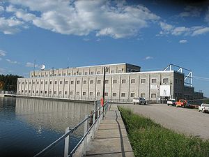
| Island Falls Island Falls, Saskatchewan Island Falls is a hydroelectric power station operated by SaskPower, a Saskatchewan crown corporation. It is located on the Churchill River at 55.5° N, 102.4° W, about sixty miles northwest of Flin Flon, Manitoba, Canada.... |
Northern Administration District | 200 | ||
| Kayville Kayville, Saskatchewan Kayville is a hamlet in the Canadian province of Saskatchewan. Listed as a designated place by Statistics Canada, the hamlet had a population of five in the Canada 2006 Census.... |
Key West No. 70 Key West No. 70, Saskatchewan Key West No. 70 is a rural municipality in the Canadian province of Saskatchewan. There are 309 people who live there. The total area of Key West No. 70 is . The population density is 0.4 people per square kilometer. There are 133 private dwellings in Key West No. 70 occupied by usual residents... |
|||
| Kingsford | Browning No. 34 Browning No. 34, Saskatchewan Browning No. 34 is a rural municipality in Saskatchewan, Canada encompassing 823.39 square kilometers in area. The rural municipality in conjunction with the provincial government is in charge of maintenance of highways in its area... |
|||
| Lakenheath | Stonehenge No. 73 Stonehenge No. 73, Saskatchewan Stonehenge No. 73 is a rural municipality in south-central Saskatchewan, Canada. It is located in Division No. 2.-Statistics:-Communities:... |
|||
| Loomis | Frontier No. 19 Frontier No. 19, Saskatchewan Frontier No. 19 is a rural municipality in the Canadian province of Saskatchewan, located in the southwestern part of the province south of the town of Eastend.-Demographics:... |
|||
| Loverna Loverna, Saskatchewan Loverna is a unincorporated hamlet in Antelope Park Rural Municipality No. 322, Saskatchewan, Canada. The population of Loverna was 5 at the 2001 Canada Census. The hamlet is approximately 50 km north west of the Town of Kindersley at the intersection of Highway 772 and Range road 290... |
Antelope Park No. 322 Antelope Park No. 322, Saskatchewan Antelope Park No. 322 is a rural municipality in the Canadian province of Saskatchewan, located in the Census Division 13. The municipality was established on December 11, 1911 in west-central Saskatchewan, Canada on the Alberta - Saskatchewan border. Antelope Park No... |
1920s | 500 | |
| Luxton | Browning No. 34 Browning No. 34, Saskatchewan Browning No. 34 is a rural municipality in Saskatchewan, Canada encompassing 823.39 square kilometers in area. The rural municipality in conjunction with the provincial government is in charge of maintenance of highways in its area... |
|||
| Masefield | Val Marie No. 17 Val Marie No. 17, Saskatchewan Val Marie No. 17 is a rural municipality in the Canadian province of Saskatchewan, located in the southwestern part of the province on the United States border... |
|||
| Maxim | Lomond No. 37 Lomond No. 37, Saskatchewan Lomond No. 37 is a rural municipality in south-eastern Saskatchewan, Canada south of Weyburn.The two principal industries in Lomond are agriculture and petroleum production.... |
|||
| Minard | Browning No. 34 | |||
| Neidpath | Coulee No. 136 Coulee No. 136, Saskatchewan Coulee No. 136 is a rural municipality in the Canadian province of Saskatchewan, located in the Census Division 7, southeast of the city of Swift Current in the southwestern region of the province. The seat of the municipality is Swift Current.-Demographics:... |
|||
| Neville Neville, Saskatchewan -External links:*******-Footnotes:... |
Whiska Creek No. 106 Whiska Creek No. 106, Saskatchewan Whiska Creek No. 106 is a rural municipality in south-western Saskatchewan, Canada encompassing 851.89 square kilometers in area. The rural municipality maintains it's office in Vanguard, Saskatchewan . The rural municipality in conjunction with the provincial government is in charge of... |
|||
| Nashlyn | Reno No. 51 Reno No. 51, Saskatchewan Reno No. 51 is a rural municipality in the Canadian province of Saskatchewan, located in the Census Division 4, just north of the USA border, and east of the Alberta border, in the southwestern corner of the province... |
|||
| Neptune | Lomond No. 37 Lomond No. 37, Saskatchewan Lomond No. 37 is a rural municipality in south-eastern Saskatchewan, Canada south of Weyburn.The two principal industries in Lomond are agriculture and petroleum production.... |
|||
| New Finland New Finland, Saskatchewan New Finland or Uusi Suomi is a district in the Qu'Appelle valley, the south eastern part of the province of Saskatchewan, Canada. Uusi Suomi is Finnish for New Finland, the name adopted by this Finnish block settlement. The homesteaders found an area in Saskatchewan near Qu'Appelle River which... |
Willowdale No. 153 Willowdale No. 153, Saskatchewan Willowdale No. 153, Saskatchewan is a rural municipality of 333 rural residents in the southeastern part of Saskatchewan, Canada. Residents also belong to SARM Division No. 1 and Census Division No. 5, Saskatchewan. The RM was incorporated January 1, 1913. No localities in this RM. The town of... |
1899 | 250 | 50°25′34″N 102°12′45″W |
| Old Wives | Hillsborough No. 132 Hillsborough No. 132, Saskatchewan Hillsborough No. 132 is a rural municipality in Saskatchewan, Canada encompassing 445.25 square kilometers in area. The rural municipality maintains it's office in Moose Jaw, Saskatchewan . The rural municipality in conjunction with the provincial government is in charge of maintenance of... |
N 50.200061 W 106.001177 | ||
| Oungre Oungre, Saskatchewan Oungre is a hamlet in the Canadian province of Saskatchewan. Listed as a designated place by Statistics Canada, the hamlet had a population of 15 in the Canada 2006 Census.... |
Souris Valley No. 7 Souris Valley No. 7, Saskatchewan Souris Valley No. 7 is a rural municipality in the Canadian province of Saskatchewan. It is located in southeastern Saskatchewan and is within SARM Division No. 1 and Census Division No. 2. Its population was 230 as of the 2006 Census.-Statistics:... |
|||
| Oxarat | Reno No. 51 Reno No. 51, Saskatchewan Reno No. 51 is a rural municipality in the Canadian province of Saskatchewan, located in the Census Division 4, just north of the USA border, and east of the Alberta border, in the southwestern corner of the province... |
|||
| Parkbeg Parkbeg, Saskatchewan Parkbeg is a hamlet in Wheatlands Rural Municipality No. 163, Saskatchewan, Canada. The hamlet is located at the junction of Highway 1 and Highway 627 approximately 58 km directly west of the City of Moose Jaw on the Trans Canada Highway.... |
Wheatlands No. 163 Wheatlands No. 163, Saskatchewan This article is about the rural municipality in Canada. For other places with the same name, see WheatlandWheatlands No. 163, Saskatchewan is a rural municipality of 164 rural residents in the southwestern part of Saskatchewan, Canada. The RM was incorporated December 13, 1909. Other localities... |
|||
| Pinto | Coalfields No. 4 Coalfields No. 4, Saskatchewan Coalfields No. 4 is a rural municipality in the Canadian province of Saskatchewan. It is located in southeastern Saskatchewan and is within SARM Division No. 1 and Census Division No. 1. Its population was 396 as of the 2006 Census.-Statistics:... |
|||
| Polwarth | Canwood No. 494 Canwood No. 494, Saskatchewan The Rural Municipality of Canwood No. 494 was firstly formed as Rural Municipality Thompson No. 494 from January 1, 1913 until April 29, 1916 before changing names to Canwood No. 494. It is located in the north central region of the province of Saskatchewan, west of Prince Albert, and completely... |
|||
| Rangeview | Reno No. 51 Reno No. 51, Saskatchewan Reno No. 51 is a rural municipality in the Canadian province of Saskatchewan, located in the Census Division 4, just north of the USA border, and east of the Alberta border, in the southwestern corner of the province... |
|||
| Ravenscrag | White Valley No. 49 White Valley No. 49, Saskatchewan White Valley No. 49 is a rural municipality in the Canadian province of Saskatchewan, located in the southwestern part of the province near Robsart.-Demographics:... |
1920s | 200 | |
| Reynaud | Three Lakes No. 400 Three Lakes No. 400, Saskatchewan Three Lakes No. 400 is a rural municipality in the Canadian province of Saskatchewan, located in the Census Division 15. The seat of the municipality is located in the Village of Middle Lake.-Demographics:... |
|||
| Robinhood Robinhood, Saskatchewan Robinhood is a hamlet in Medstead Rural Municipality No. 497, Saskatchewan, Canada. The hamlet is located at the junction of Highway 794 and Range road 160, approximately 10 km west of the Village of Medstead.... |
Medstead No. 497 Medstead No. 497, Saskatchewan Medstead No. 497 is a rural municipality in the Canadian province of Saskatchewan. The municipality is located in the Census Division 16 which is a part of SARM Division 6. The seat of the municipality is located in the Village of Medstead.-Demographics:... |
1940 | 60 | |
| Robsart Robsart, Saskatchewan Robsart is a hamlet in Reno Rural Municipality No. 51, Saskatchewan, Canada. The population was 15 at the 2001 Census. The hamlet is located at the junction of Highway 18 and Highway 13 which is also known as the historic Red Coat Trail approximately 170 km south-east of Medicine Hat, Alberta... |
Reno No. 51 Reno No. 51, Saskatchewan Reno No. 51 is a rural municipality in the Canadian province of Saskatchewan, located in the Census Division 4, just north of the USA border, and east of the Alberta border, in the southwestern corner of the province... |
1920s | 350 | |
| Romance | Leroy No. 339 Leroy No. 339, Saskatchewan Leroy No. 339, Saskatchewan is a rural municipality in central Saskatchewan, Canada east of Saskatoon Leroy No. 339 started out with the name Roach from January 1, 1913 until March 14, 1914 when the name changed to Ayr. Ayr remained the name after 1914 through until February 27, 1931 when it... |
|||
| Roseray Roseray, Saskatchewan Roseray is a hamlet in Saskatchewan.... |
Pittville No. 169 Pittville No. 169, Saskatchewan Pittville No. 169 is a rural municipality in the Canadian province of Saskatchewan, located in the southwestern region of the province, northwest of the town of Gull Lake.-Demographics:... |
|||
| Rutland | Colonsay No. 342 Colonsay No. 342, Saskatchewan Colonsay No. 342 is a rural municipality in central Saskatchewan, Canada, east of Saskatoon. It is located inCensus Division number 11. The rural area population of the RM has been declining over the past few years.... |
|||
| Scotsguard Scotsguard, Saskatchewan Scotsguard is a small hamlet in Bone Creek Rural Municipality No. 108, Saskatchewan, Canada. Located on highway 13 also known as the historic Red Coat Trail, about 10 km northeast of Shaunavon, Saskatchewan.-Demographics:... |
Bone Creek No. 108 Bone Creek No. 108, Saskatchewan The Rural Municipality of Bone Creek No. 108 is a rural municipality in the Canadian province of Saskatchewan. Bone Creek #108 is located in south western, Saskatchewan, in SARM Division 3 and the Census division No. 4 .-Demographics:... |
1916–1935 | 350 | |
| Senate | Reno No. 51 Reno No. 51, Saskatchewan Reno No. 51 is a rural municipality in the Canadian province of Saskatchewan, located in the Census Division 4, just north of the USA border, and east of the Alberta border, in the southwestern corner of the province... |
1940s | 63 | |
| Shand | Estavan No. 5 | |||
| Smuts | Grant No. 372 Grant No. 372, Saskatchewan Grant No. 372 is a rural municipality in north-central Saskatchewan, Canada encompassing 802.93 square kilometers in area. The rural municipality maintains its office in Vonda, Saskatchewan. The rural municipality in conjunction with the provincial government is in charge of maintenance of... |
|||
| Southall | Souris Valley No. 7 Souris Valley No. 7, Saskatchewan Souris Valley No. 7 is a rural municipality in the Canadian province of Saskatchewan. It is located in southeastern Saskatchewan and is within SARM Division No. 1 and Census Division No. 2. Its population was 230 as of the 2006 Census.-Statistics:... |
|||
| South Fork | Arlington No. 79 Arlington No. 79, Saskatchewan Arlington No. 79 is a rural municipality in the Canadian province of Saskatchewan, located in the southwestern region of the province east of Shaunavon. The seat of the municipality is located in Shaunavon due to such a small population.-Demographics:... |
|||
| St. Boswells | Glen Bain No. 105 Glen Bain No. 105, Saskatchewan Glen Bain No. 105 is a rural municipality in the Canadian province of Saskatchewan, located in the Census Division 3, in the southcentral region of the province. The seat of the municipality is located in the village of Glen Bain.-Demographics:... |
1919–1929 | 350 | |
| Tableland | Saskatchewan Saskatchewan Saskatchewan is a prairie province in Canada, which has an area of . Saskatchewan is bordered on the west by Alberta, on the north by the Northwest Territories, on the east by Manitoba, and on the south by the U.S. states of Montana and North Dakota.... |
|||
| Tarnopol Tarnopol, Saskatchewan Tarnopol is a hamlet in Saskatchewan, Canada, located 50 km southwest of the city of Melfort. It was settled mostly by Ukrainian and Polish immigrants in the early 1900s... |
Invergordon No. 430 Invergordon No. 430, Saskatchewan Invergordon No. 430, Saskatchewan was established December 11, 1911. It is a rural municipality of Saskatchewan located west of Melfort, Saskatchewan.-Statistics:According to the Canada 2001 Census:*Population: 664... |
|||
| Tatagwa | Weyburn No. 67 Weyburn No. 67, Saskatchewan Weyburn No. 67 is a rural municipality in south-eastern Saskatchewan, Canada encompassing 811.70 square kilometers in area. The rural municipality maintains its office in Weyburn, Saskatchewan . Located within the area of the rural municipality are the communities of North Weyburn, McTaggart... |
|||
| Tate | Mount Hope No. 279 Mount Hope No. 279, Saskatchewan Mount Hope No. 279 is a rural municipality in the Canadian province of Saskatchewan, located in the Census Division 10. The seat of the municipality is located in the Village of Semans.-Demographics:... |
|||
| Taylorton | Coalfields No. 4 Coalfields No. 4, Saskatchewan Coalfields No. 4 is a rural municipality in the Canadian province of Saskatchewan. It is located in southeastern Saskatchewan and is within SARM Division No. 1 and Census Division No. 1. Its population was 396 as of the 2006 Census.-Statistics:... |
|||
| Trossachs Trossachs, Saskatchewan Trossachs is a hamlet in the Canadian province of Saskatchewan. Listed as a designated place by Statistics Canada, the hamlet had a population of 33 in the Canada 2006 Census.... |
Brokenshell No. 68 Brokenshell No. 68, Saskatchewan Brokenshell No. 68 is a rural municipality in south-eastern Saskatchewan, Canada encompassing 850.01 square kilometers in area. The rural municipality maintained its office in Trossachs, Saskatchewan until 1941 when permission was received to share offices with RM Weyburn with technical... |
|||
| Truax Truax, Saskatchewan Truax is a hamlet that, as of 2009, does not have 'organized hamlet' status in Saskatchewan, Canada. It is located 80 km southwest of Regina and approximately 75 km southeast of Moose Jaw. Truax was incorporated as a village in on September 9, 1912... |
Elmsthorpe No. 100 Elmsthorpe No. 100, Saskatchewan Elmsthorpe No. 100 is a rural municipality in south-eastern Saskatchewan, Canada encompassing 843.12 square kilometers in area. The rural municipality maintains it's office in Avonlea, Saskatchewan. The communities of Truax, Claybank and Crystal Hill are within the rural municipality... |
|||
| Union Jack | Weyburn No. 67 Weyburn No. 67, Saskatchewan Weyburn No. 67 is a rural municipality in south-eastern Saskatchewan, Canada encompassing 811.70 square kilometers in area. The rural municipality maintains its office in Weyburn, Saskatchewan . Located within the area of the rural municipality are the communities of North Weyburn, McTaggart... |
|||
| Uren Uren, Saskatchewan Uren is a community in Saskatchewan.... |
Chaplin No. 164 Chaplin No. 164, Saskatchewan -Area statistics:*Lat 50.416765762°*Long -106.584534688*Time zone UTC-6-External links:********- References :... |
|||
| Valjean | Chaplin No. 164 Chaplin No. 164, Saskatchewan -Area statistics:*Lat 50.416765762°*Long -106.584534688*Time zone UTC-6-External links:********- References :... |
|||
| Valley Center | Marriott No. 317 Marriott No. 317, Saskatchewan Marriott No. 317 is a rural municipality in the Canadian province of Saskatchewan, located in Census Division 12. The seat of the municipality is located in the village of Rosetown, which actually lies within the adjacent rural municipality of St. Andrews No. 287.-Demographics:In 2006, the Rural... |
|||
| Vantage Vantage, Saskatchewan Vantage is a hamlet in the Canadian province of Saskatchewan. Listed as a designated place by Statistics Canada, the hamlet had a reported population of zero in the Canada 2006 Census.Vantage Methodist Church 1917Vantage, Saskatchewan... |
Sutton No. 103 Sutton No. 103, Saskatchewan Sutton No. 103 is a rural municipality in Saskatchewan, Canada encompassing 822.40 square kilometers in area. The rural municipality maintains it's office in Mossbank, Saskatchewan . The rural municipality in conjunction with the provincial government is in charge of maintenance of highways in... |
|||
| Verlo | Pittville No. 169 Pittville No. 169, Saskatchewan Pittville No. 169 is a rural municipality in the Canadian province of Saskatchewan, located in the southwestern region of the province, northwest of the town of Gull Lake.-Demographics:... |
|||
| Vesper | Lac Pelletier No. 107 Lac Pelletier No. 107, Saskatchewan Lac Pelletier No. 107 is a rural municipality in the Canadian province of Saskatchewan, located in the Census Division 4, in the southwestern corner of the province. The seat of the municipality is located in the village of Neville.-Demographics:... |
N 50.016766334 W 108.018071486 | ||
| Vidora Vidora, Saskatchewan Vidora is a hamlet in Reno Rural Municipality No. 51, Saskatchewan, Canada. The hamlet is located between the hamlet of Robsart and the village of Consul on Highway 13 known as the Red Coat Trail. Very little remains of the former village, only one home that is also used as a post office still... |
Reno No. 51 Reno No. 51, Saskatchewan Reno No. 51 is a rural municipality in the Canadian province of Saskatchewan, located in the Census Division 4, just north of the USA border, and east of the Alberta border, in the southwestern corner of the province... |
1920s | 200 | |
| Viewfield | Benson No. 35 Benson No. 35, Saskatchewan Benson No. 35 is a rural municipality in south-east Saskatchewan, Canada encompassing 836.39 square kilometers in area. The rural municipality has within its boundaries the communities of Benson and Bryant, Saskatchewan. The rural municipality maintains offices in the community of Benson... |
|||
| Woodley | Browning No. 34 Browning No. 34, Saskatchewan Browning No. 34 is a rural municipality in Saskatchewan, Canada encompassing 823.39 square kilometers in area. The rural municipality in conjunction with the provincial government is in charge of maintenance of highways in its area... |
|||
| Xena Xena, Saskatchewan Xena, Saskatchewan was formerly a village in Saskatchewan. The last building was demolished in the 1970s. It is presently an unincorporated area in the rural municipality of Morris No. 312, in the Canadian province of Saskatchewan. Xena is located on Highway 2 in central Saskatchewan... |
Morris No. 312 Morris No. 312, Saskatchewan Morris No. 312 is a rural municipality in north-central Saskatchewan, Canada on the South Saskatchewan River. It is located in Division No. 15.According to the Canada 2001 Census:*Population: 410*% Change : -8.5*Dwellings: 160... |
|||
| Yonker | N 52.652645 W 109.638748 | |||
See also
- List of places with fewer than ten residents
- List of Canadian Cities, Towns & Villages
- List of ghost towns in Canada
- List of towns in Saskatchewan
- List of rural municipalities in Saskatchewan
- List of Indian reserves in Saskatchewan
- Census divisions of SaskatchewanCensus divisions of SaskatchewanThe province of Saskatchewan, Canada is divided into 18 census divisions according to Statistics Canada. See also List of communities in Saskatchewan.-List of census divisions:They are shown with their most populous community....
- List of ghost towns in Alberta