
Georgia State Route 35
Encyclopedia
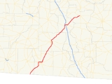
State Route 35 is a north–south state route located in the southern part of the U.S. state
of Georgia
. The route travels from the Florida
state line south of Cairo
northeast to SR 32
in Ocilla
. The route is cosigned
with U.S. Route 319
for its entire length.
, State Route 35, cosigned with U.S. 319, travels northeast into Thomas County
. The two routes arc to the west and north around Thomasville
, briefly becoming cosigned with U.S. 84
/S.R. 38
and State Route 3 Alernate. State Route 35 continues northeast through Colquitt County
, bypassing Moultrie
to the east, and enters Tift County
. After an interchange with Interstate 75
/State Route 401
and a brief cosignage with U.S. 82
/S.R. 520
in Tifton
, S.R. 35 continues northeast into Irwin County
, where SR 35 meets its northern terminus at SR 32 in Ocilla. U.S. 319 continues north.
State Route 35 is a significant route in south Georgia, with an Average Annual Daily Traffic of over 5,000 vehicles south of Tifton, and over 10,000 near Moultrie and Thomasville.
, State Route 300
, State Route 3
/U.S. 84
, SR 84
, and is across from the Wal-Mart Supercenter, formerly U.S. 319 Business and SR 35 Business in Thomasville.
Georgia State Route 35 Business, the former Route which serves the downtown area of Thomasville. The route was Decommissioned in 2007.
U.S. state
A U.S. state is any one of the 50 federated states of the United States of America that share sovereignty with the federal government. Because of this shared sovereignty, an American is a citizen both of the federal entity and of his or her state of domicile. Four states use the official title of...
of Georgia
Georgia (U.S. state)
Georgia is a state located in the southeastern United States. It was established in 1732, the last of the original Thirteen Colonies. The state is named after King George II of Great Britain. Georgia was the fourth state to ratify the United States Constitution, on January 2, 1788...
. The route travels from the Florida
Florida
Florida is a state in the southeastern United States, located on the nation's Atlantic and Gulf coasts. It is bordered to the west by the Gulf of Mexico, to the north by Alabama and Georgia and to the east by the Atlantic Ocean. With a population of 18,801,310 as measured by the 2010 census, it...
state line south of Cairo
Cairo, Georgia
Cairo is a city in Grady County, Georgia, United States. As of the 2010 census, the city had a population of 9,607. The city is the county seat of Grady County.-Syrup City:...
northeast to SR 32
Georgia State Route 32
State Route 32 is a west–east state route located in the southern part of the U.S. state of Georgia. The route travels from SR 520 in Dawson east to SR 99 west of Sterling.-Route description:...
in Ocilla
Ocilla, Georgia
Ocilla is a city in Irwin County, Georgia, United States. The population was 3,270 at the 2000 census. The city is the county seat of Irwin County.Ocilla is part of the Fitzgerald Micropolitan Statistical Area.-Geography:...
. The route is cosigned
Concurrency (road)
A concurrency, overlap, or coincidence in a road network is an instance of one physical road bearing two or more different highway, motorway, or other route numbers...
with U.S. Route 319
U.S. Route 319
U.S. Highway 319 is a spur of U.S. Route 19. It runs for 318 miles from US 1 /State Route 4 in Wadley, Georgia to the John Gorrie Bridge at Apalachicola, Florida. The sections of US 319 in Medart, Florida and from just east of Carrabelle, Florida to its terminus in Apalachicola are jointly...
for its entire length.
Route description
From its southern terminus at Florida State Road 61 at the Florida state line south of Cairo in Grady CountyGrady County, Georgia
Grady County is a county located in the U.S. state of Georgia. As of 2000, the population was 23,659. The 2007 Census Estimate shows a population of 25,042. The county seat is Cairo.- History :...
, State Route 35, cosigned with U.S. 319, travels northeast into Thomas County
Thomas County, Georgia
Thomas County is a county located in the U.S. state of Georgia. The 2010 Census showed a population of 44,720. The county seat is Thomasville.-History:...
. The two routes arc to the west and north around Thomasville
Thomasville, Georgia
Thomasville is the county seat of Thomas County, Georgia, United States. The city is the second largest in Southwest Georgia after Albany.The city deems itself the City of Roses and holds an annual Rose Festival. The town features plantations open to the public, a historic downtown, a large...
, briefly becoming cosigned with U.S. 84
U.S. Route 84
U.S. Route 84 is an east–west United States highway. It started as a short Georgia-Alabama route in the original 1926 scheme, but now extends all the way to Colorado. The highway's eastern terminus is a short distance east of Midway, Georgia, at an intersection with I-95. The road continues...
/S.R. 38
U.S. Route 84 in Georgia
U.S. Route 84 in Georgia, is also signed as State Route 38 for its entire length in Georgia. After entering Georgia from Alabama west of Jakin, Georgia, the route travels through the southern portion of the state, meeting its eastern terminus at Interstate 95 east of Midway. U.S...
and State Route 3 Alernate. State Route 35 continues northeast through Colquitt County
Colquitt County, Georgia
Colquitt County is a county located in the U.S. state of Georgia. It was created on February 25, 1856. As of 2000, the population was 42,053. The 2007 Census Estimate shows a population of 45,744. The county seat is Moultrie...
, bypassing Moultrie
Moultrie, Georgia
Moultrie is the county seat and largest city of Colquitt County and the third largest in Southwest Georgia behind Thomasville and Albany. As of 2009, Moultrie's population is 15,199 people. Since 2000, it has had a population growth of 6.07 percent....
to the east, and enters Tift County
Tift County, Georgia
Tift County is a county located in the U.S. state of Georgia. As of 2000, the population was 38,407. The 2007 Census Estimate shows a population of 41,610...
. After an interchange with Interstate 75
Interstate 75
Interstate 75 is a major north–south Interstate Highway in the Great Lakes and Southeastern regions of the United States. It travels from State Road 826 and State Road 924 in Hialeah, Florida to Sault Ste. Marie, Michigan, at the Ontario, Canada, border...
/State Route 401
Interstate 75 in Georgia
In the U.S. state of Georgia, Interstate 75 runs north–south along the U.S. Route 41 corridor on the western side of the state, passing through the cities of Valdosta, Macon and Atlanta. It is also designated — but not signed — as State Route 401...
and a brief cosignage with U.S. 82
U.S. Route 82
U.S. Route 82 is an east–west United States highway in the southern United States. What started as a 1932 addition to the system across central Mississippi and southern Arkansas eventually became a 1,609 mile route extending from the White Sands of New Mexico to Georgia's Atlantic coast.The...
/S.R. 520
Georgia State Route 520
State Route 520, also known as the South Georgia Parkway, is a state route in southern Georgia. Its western terminus occurs at the Alabama state line on a bridge over the Chattahoochee River that also carries U.S. Highway 280. Georgia 520 becomes unsigned State Route 38 upon crossing the border. ...
in Tifton
Tifton, Georgia
Tifton is a city in Tift County, Georgia, United States. The population was 15,060 at the 2000 census. The city is the county seat of Tift County.-Major highways:* Interstate 75* U.S. Highway 41* U.S. Highway 82* U.S...
, S.R. 35 continues northeast into Irwin County
Irwin County, Georgia
Irwin County is a county located in the U.S. state of Georgia. It was created on December 15, 1818. As of 2000, the population was 9,931. The 2007 Census Estimate shows a population of 9,934...
, where SR 35 meets its northern terminus at SR 32 in Ocilla. U.S. 319 continues north.
State Route 35 is a significant route in south Georgia, with an Average Annual Daily Traffic of over 5,000 vehicles south of Tifton, and over 10,000 near Moultrie and Thomasville.
Banner routes
Georgia State Route 35 Connector, which is the Southern Terminus of U.S. 19U.S. Route 19
U.S. Route 19 is a north–south U.S. Highway. Despite encroaching Interstate Highways, the route has remained a long-haul route, connecting the Gulf of Mexico with Lake Erie....
, State Route 300
Georgia State Route 300
State Route 300, also called the Georgia-Florida Parkway, is a long route that runs from Florida State Road 57 at the Florida-Georgia state line south of Thomasville in Thomas County, north to I-75 in Cordele in Crisp County.-Route description:...
, State Route 3
Georgia State Route 3
State Route 3 runs in a generally north–south orientation from Georgia's northern border to its southern border. Its northern terminus is at the Tennessee state line just southeast of Chattanooga , and its southern terminus is at the Florida state line about twelve miles south-southeast of...
/U.S. 84
U.S. Route 84
U.S. Route 84 is an east–west United States highway. It started as a short Georgia-Alabama route in the original 1926 scheme, but now extends all the way to Colorado. The highway's eastern terminus is a short distance east of Midway, Georgia, at an intersection with I-95. The road continues...
, SR 84
U.S. Route 84 in Georgia
U.S. Route 84 in Georgia, is also signed as State Route 38 for its entire length in Georgia. After entering Georgia from Alabama west of Jakin, Georgia, the route travels through the southern portion of the state, meeting its eastern terminus at Interstate 95 east of Midway. U.S...
, and is across from the Wal-Mart Supercenter, formerly U.S. 319 Business and SR 35 Business in Thomasville.
Georgia State Route 35 Business, the former Route which serves the downtown area of Thomasville. The route was Decommissioned in 2007.