

Geography of Yemen
Encyclopedia
| Geography of Yemen | |
 |
|
| Continent | Asia Asia Asia is the world's largest and most populous continent, located primarily in the eastern and northern hemispheres. It covers 8.7% of the Earth's total surface area and with approximately 3.879 billion people, it hosts 60% of the world's current human population... |
| Region | Middle East Middle East The Middle East is a region that encompasses Western Asia and Northern Africa. It is often used as a synonym for Near East, in opposition to Far East... |
| Coordinates | 15°N 48°E |
| Area | Ranked 50th 527,968 km2 |
| Coastline | 1,906 km |
| Borders | 1,746 km (Oman Oman Oman , officially called the Sultanate of Oman , is an Arab state in southwest Asia on the southeast coast of the Arabian Peninsula. It is bordered by the United Arab Emirates to the northwest, Saudi Arabia to the west, and Yemen to the southwest. The coast is formed by the Arabian Sea on the... 288 km, Saudi Arabia Saudi Arabia The Kingdom of Saudi Arabia , commonly known in British English as Saudi Arabia and in Arabic as as-Sa‘ūdiyyah , is the largest state in Western Asia by land area, constituting the bulk of the Arabian Peninsula, and the second-largest in the Arab World... 1,458 km) |
| Highest point | Jabal an Nabi Shu'ayb Jabal an Nabi Shu'ayb Jabal an-Nabi Shu'ayb is a mountain located in Sana'a Governorate, Yemen. It is the highest mountain of the country and the highest mountain in the Arabian Peninsula... 3,667 m |
| Lowest point | Arabian Sea Arabian Sea The Arabian Sea is a region of the Indian Ocean bounded on the east by India, on the north by Pakistan and Iran, on the west by the Arabian Peninsula, on the south, approximately, by a line between Cape Guardafui in northeastern Somalia and Kanyakumari in India... , 0 m |
Yemen
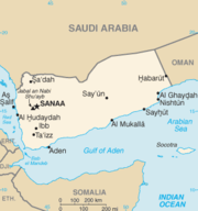
The Republic of Yemen , commonly known as Yemen , is a country located in the Middle East, occupying the southwestern to southern end of the Arabian Peninsula. It is bordered by Saudi Arabia to the north, the Red Sea to the west, and Oman to the east....
is located in Southwest Asia
Southwest Asia
Western Asia, West Asia, Southwest Asia or Southwestern Asia are terms that describe the westernmost portion of Asia. The terms are partly coterminous with the Middle East, which describes a geographical position in relation to Western Europe rather than its location within Asia...
at the southern tip of the Arabian Peninsula
Arabian Peninsula
The Arabian Peninsula is a land mass situated north-east of Africa. Also known as Arabia or the Arabian subcontinent, it is the world's largest peninsula and covers 3,237,500 km2...
between Oman
Oman
Oman , officially called the Sultanate of Oman , is an Arab state in southwest Asia on the southeast coast of the Arabian Peninsula. It is bordered by the United Arab Emirates to the northwest, Saudi Arabia to the west, and Yemen to the southwest. The coast is formed by the Arabian Sea on the...
and Saudi Arabia
Saudi Arabia
The Kingdom of Saudi Arabia , commonly known in British English as Saudi Arabia and in Arabic as as-Sa‘ūdiyyah , is the largest state in Western Asia by land area, constituting the bulk of the Arabian Peninsula, and the second-largest in the Arab World...
. It is situated at the entrance to the Bab-el-Mandeb
Bab-el-Mandeb
The Bab-el-Mandeb meaning "Gate of Grief" in Arabic , is a strait located between Yemen on the Arabian Peninsula, Djibouti and Eritrea, north of Somalia, in the Horn of Africa, and connecting the Red Sea to the Gulf of Aden...
Strait, which links the Red Sea
Red Sea
The Red Sea is a seawater inlet of the Indian Ocean, lying between Africa and Asia. The connection to the ocean is in the south through the Bab el Mandeb strait and the Gulf of Aden. In the north, there is the Sinai Peninsula, the Gulf of Aqaba, and the Gulf of Suez...
to the Indian Ocean
Indian Ocean
The Indian Ocean is the third largest of the world's oceanic divisions, covering approximately 20% of the water on the Earth's surface. It is bounded on the north by the Indian Subcontinent and Arabian Peninsula ; on the west by eastern Africa; on the east by Indochina, the Sunda Islands, and...
(via the Gulf of Aden
Gulf of Aden
The Gulf of Aden is located in the Arabian Sea between Yemen, on the south coast of the Arabian Peninsula, and Somalia in the Horn of Africa. In the northwest, it connects with the Red Sea through the Bab-el-Mandeb strait, which is about 20 miles wide....
) and is one of the most active and strategic shipping lanes in the world. Yemen has an area of 527970 square kilometres (203,850.4 sq mi), including the islands of Perim
Perim
Perim is a volcanic island strategically located in the Strait of Mandeb at the southern entrance into the Red Sea, off the southwestern coast of Yemen, at . It has a surface area of 13 square kilometers and rises to an altitude of 65 meters. The island has a natural harbour on its southwestern...
at the southern end of the Red Sea and Socotra
Socotra
Socotra , also spelt Soqotra, is a small archipelago of four islands in the Indian Ocean. The largest island, also called Socotra, is about 95% of the landmass of the archipelago. It lies some east of the Horn of Africa and south of the Arabian Peninsula. The island is very isolated and through...
at the entrance to the Gulf of Aden. Yemen’s land boundaries total 1746 kilometres (1,084.9 mi). Yemen borders Saudi Arabia to the north (1458 km (906 mi)) and Oman to the northeast (288 km (179 mi)).
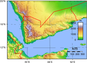
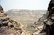
Topography
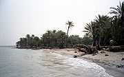
Yemen occupies the southern end of the Arabian plateau.The country’s mountainous interior is surrounded by narrow coastal plains to the west, south, and east and by upland desert to the north along the border with Saudi Arabia. The Tihamah
Tihamah
Tihamah or Tihama is a narrow coastal region of Arabia on the Red Sea. It is currently divided between Saudi Arabia and Yemen. In a broad sense, Tihamah refers to the entire coastline from the Gulf of Aqaba to the Bab el Mandeb Strait but it more often refers only to its southern half, starting...
is a nearly 419 kilometres (260.4 mi) long, semidesert coastal plain that runs along the Red Sea
Red Sea
The Red Sea is a seawater inlet of the Indian Ocean, lying between Africa and Asia. The connection to the ocean is in the south through the Bab el Mandeb strait and the Gulf of Aden. In the north, there is the Sinai Peninsula, the Gulf of Aqaba, and the Gulf of Suez...
and is part of the Arabian Peninsula coastal fog desert
Arabian Peninsula coastal fog desert
The Arabian Peninsula coastal fog desert on the southern coasts of the Arabian peninsula is an ecoregion which experiences thick fogs where visibility may be reduced to 33 feet . It is classed as a Afrotropic fog desert -Location and description:...
ecoregion
Ecoregion
An ecoregion , sometimes called a bioregion, is an ecologically and geographically defined area that is smaller than an ecozone and larger than an ecosystem. Ecoregions cover relatively large areas of land or water, and contain characteristic, geographically distinct assemblages of natural...
.
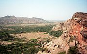
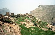
The interior mountains have elevations ranging from a few hundred meters to the country’s highest point, Jabal an Nabi Shuayb, which is 3666 m (12,027.6 ft) above sea level. The mountains are young, jagged peaks that are known to rise from an elevation of a few hundred meters to well over 3,000. The mountains can be separated into a western and central highland. The western highlands have peaks reaching around 3,000 meters, with relatively fertile soil and sufficient and plentiful rainfall. The central highlands is more like a plateau of about 2,000-3,200 meters, with rolling hills, small knolls, and some very prominent peaks, but is still relatively more elevated. Less rainfall can be seen in this region, but the summer months give enough to sustain crops.
The highland regions are interspersed with wadi
Wadi
Wadi is the Arabic term traditionally referring to a valley. In some cases, it may refer to a dry riverbed that contains water only during times of heavy rain or simply an intermittent stream.-Variant names:...
s, or river valleys, that are dry in the summer months. (Yemen has no permanent rivers.) Most notable is the Wadi Hadhramaut in eastern Yemen, the upper portions of which contain alluvial soil and floodwaters and the lower portion of which is barren and largely uninhabited. Both the eastern plateau region and the desert in the north are hot and dry with little vegetation.
In the northeastern Empty Quarter
Empty Quarter
The Rub' al Khali or Empty Quarter is one of the largest sand deserts in the world, encompassing most of the southern third of the Arabian Peninsula, including most of Saudi Arabia and areas of Oman, the United Arab Emirates, and Yemen. The desert covers some The Rub' al Khali or Empty Quarter...
, sands highlight the region, being the largest expanse of sand in the world. It receives little to no rain for extensive periods of time. Little vegetation grows here either.
The central highlands are drier than the western highlands because of rain-shadow influences, but still receives sufficient rain in wet years for extensive cropping. Its diurnal temperature variation
Diurnal temperature variation
Diurnal temperature variation is a meteorological term that relates to the variation in temperature that occurs from the highs of the day to the cool of nights.-Temperature lag:Temperature lag is an important factor in diurnal temperature variation...
s are among the highest in the world: ranges from 30 °C (86 °F) in the day to 0 °C (32 °F) at night are normal. Water storage allows for irrigation and the growing of wheat and barley while the western highlands are famous for sorghum
Sorghum
Sorghum is a genus of numerous species of grasses, one of which is raised for grain and many of which are used as fodder plants either cultivated or as part of pasture. The plants are cultivated in warmer climates worldwide. Species are native to tropical and subtropical regions of all continents...
, coffee
Coffee
Coffee is a brewed beverage with a dark,init brooo acidic flavor prepared from the roasted seeds of the coffee plant, colloquially called coffee beans. The beans are found in coffee cherries, which grow on trees cultivated in over 70 countries, primarily in equatorial Latin America, Southeast Asia,...
, and some tropical fruits like bananas and mangos.
Elevation
Yemen is a continuously elevated country, with only the coastal plains being the lowest-lying areas. The range of elevation is from sea levelSea level
Mean sea level is a measure of the average height of the ocean's surface ; used as a standard in reckoning land elevation...
to 3666 metres (12,027.6 ft). Jagged peaks and plateaus cover most of Yemen, and the average elevation in the country is about 2000 metres (6,561.7 ft). It has the second highest peak in the Arab world, Jabal an Nabi Shu'ayb
Jabal an Nabi Shu'ayb
Jabal an-Nabi Shu'ayb is a mountain located in Sana'a Governorate, Yemen. It is the highest mountain of the country and the highest mountain in the Arabian Peninsula...
, after Jbel Toubkal in the Moroccan
Morocco
Morocco , officially the Kingdom of Morocco , is a country located in North Africa. It has a population of more than 32 million and an area of 710,850 km², and also primarily administers the disputed region of the Western Sahara...
Atlas Mountains
Atlas Mountains
The Atlas Mountains is a mountain range across a northern stretch of Africa extending about through Morocco, Algeria, and Tunisia. The highest peak is Toubkal, with an elevation of in southwestern Morocco. The Atlas ranges separate the Mediterranean and Atlantic coastlines from the Sahara Desert...
. The Yemenis used the elevation of their homeland to stay isolated for thousands of years with foreign trade conducted only when the Yemenis wished to go to the coastal areas.
Climate
Temperatures are generally very high in Yemen, particularly in the coastal regions. Rainfall is limited, with variations based on elevation. The highlands enjoy a temperate, rainy summer with an average high temperature of 21 °C (69.8 °F) and a cool, moderately dry winter with temperatures occasionally dipping below 0 °C (32 °F). The climate of the TihamahTihamah
Tihamah or Tihama is a narrow coastal region of Arabia on the Red Sea. It is currently divided between Saudi Arabia and Yemen. In a broad sense, Tihamah refers to the entire coastline from the Gulf of Aqaba to the Bab el Mandeb Strait but it more often refers only to its southern half, starting...
(western coastal plain) is tropical; temperatures occasionally exceed 54 °C (129.2 °F), and the humidity ranges from 50 to 70 percent. Rainfall, which comes in irregular heavy torrents, averages 130 millimetres (5.12 in) annually. In Aden the average temperature is 25 °C (77 °F) in January and 32 °C (89.6 °F) in June, but with highs often exceeding 37 °C (98.6 °F). Average annual rainfall is 127 millimetres (5 in). The highest mountainous areas of southern Yemen receive from 520 to 760 mm (20.5 to 29.9 in) of rain a year. Some areas of the western highlands, most notably Ibb and Ta'izz, receive from about 1000–1500 mm (39.4–59.1 in) of rain each year. The capital, Sana'a, receives around 300 mm (11.8 in) a year, It is not uncommon for the northern and eastern sections of the country to receive no rain for five years or more. The Wadi Hadhramaut in the eastern part of Yemen is arid and hot, and the humidity ranges from 35 percent in June to 64 percent in January. Yemen is dry in the east and humid in the west.
Coastline and maritime claims
Yemen has 1906 kilometres (1,184.3 mi) of coastline along the Arabian SeaArabian Sea
The Arabian Sea is a region of the Indian Ocean bounded on the east by India, on the north by Pakistan and Iran, on the west by the Arabian Peninsula, on the south, approximately, by a line between Cape Guardafui in northeastern Somalia and Kanyakumari in India...
, the Gulf of Aden
Gulf of Aden
The Gulf of Aden is located in the Arabian Sea between Yemen, on the south coast of the Arabian Peninsula, and Somalia in the Horn of Africa. In the northwest, it connects with the Red Sea through the Bab-el-Mandeb strait, which is about 20 miles wide....
, and the Red Sea. Yemen claims a territorial sea of 12 nmi (13.8 mi; 22.2 km), a contiguous zone of 24 nmi (27.6 mi; 44.4 km), an exclusive economic zone of 200 nmi (230.2 mi; 370.4 km), and a continental shelf of 200 nmi (230.2 mi; 370.4 km) or to the edge of the continental margin.
Natural Resources
Yemen’s principal natural resources are oil and natural gas as well as agriculturally productive land in the west. Other natural resources include fish and seafood, rock salt, marble, and minor deposits of coalCoal
Coal is a combustible black or brownish-black sedimentary rock usually occurring in rock strata in layers or veins called coal beds or coal seams. The harder forms, such as anthracite coal, can be regarded as metamorphic rock because of later exposure to elevated temperature and pressure...
, gold
Gold
Gold is a chemical element with the symbol Au and an atomic number of 79. Gold is a dense, soft, shiny, malleable and ductile metal. Pure gold has a bright yellow color and luster traditionally considered attractive, which it maintains without oxidizing in air or water. Chemically, gold is a...
, lead
Lead
Lead is a main-group element in the carbon group with the symbol Pb and atomic number 82. Lead is a soft, malleable poor metal. It is also counted as one of the heavy metals. Metallic lead has a bluish-white color after being freshly cut, but it soon tarnishes to a dull grayish color when exposed...
, nickel
Nickel
Nickel is a chemical element with the chemical symbol Ni and atomic number 28. It is a silvery-white lustrous metal with a slight golden tinge. Nickel belongs to the transition metals and is hard and ductile...
, and copper
Copper
Copper is a chemical element with the symbol Cu and atomic number 29. It is a ductile metal with very high thermal and electrical conductivity. Pure copper is soft and malleable; an exposed surface has a reddish-orange tarnish...
.
Land Use
Only 2.9 percent of Yemen is considered to be arable land, and less than 0.3 percent of the land is planted with permanent crops. About 4900 square kilometres (1,891.9 sq mi) of land are irrigated. According to the United NationsUnited Nations
The United Nations is an international organization whose stated aims are facilitating cooperation in international law, international security, economic development, social progress, human rights, and achievement of world peace...
, Yemen has 19550 square kilometres (7,548.3 sq mi) of forest and other wooded land, which constitutes almost 4 percent of total land area.
Environmental factors
Yemen is subject to sandstorms and dust storms, resulting in soil erosion and crop damage. The country has very limited natural freshwater and consequently inadequate supplies of potable water. Desertification (land degradation caused by aridity) and overgrazing are also problems. It is a party to international BiodiversityBiodiversity
Biodiversity is the degree of variation of life forms within a given ecosystem, biome, or an entire planet. Biodiversity is a measure of the health of ecosystems. Biodiversity is in part a function of climate. In terrestrial habitats, tropical regions are typically rich whereas polar regions...
, Climate Change, Desertification, Endangered Species, Environmental Modification, Hazardous Wastes, Law of the Sea, Nuclear Test Ban, Ozone Layer Protection agreements.
Disputed territory
A long-standing dispute between Saudi Arabia and Yemen was resolved in June 2000 with the signing of the Treaty of Jeddah. This agreement provides coordinates for use in delineating the land and maritime border, including the section in the eastern desert region of Yemen that potentially contains significant amounts of oil. Friction between the two countries in recent years over security of the borders appears to have been alleviated by the establishment of joint border patrols. Following years of dispute between Yemen and EritreaEritrea
Eritrea , officially the State of Eritrea, is a country in the Horn of Africa. Eritrea derives it's name from the Greek word Erethria, meaning 'red land'. The capital is Asmara. It is bordered by Sudan in the west, Ethiopia in the south, and Djibouti in the southeast...
over ownership of the Hanish Islands
Hanish Islands
The Hanish Islands are an island group in the Red Sea. Most of them are a part of Yemen, but before 1998–1999 they were claimed by Eritrea as well. After a long trial with an international court under the guidance of Dr...
and fishing rights in the Red Sea, in 1999 an international arbitration panel awarded sovereignty of the islands to Yemen. Relations between the two countries remain strained, and Yemen continues to protest Eritrean fishing in the disputed territory.