

Geography of Kenya
Encyclopedia
Geography
Geography is the science that studies the lands, features, inhabitants, and phenomena of Earth. A literal translation would be "to describe or write about the Earth". The first person to use the word "geography" was Eratosthenes...
of Kenya
Kenya
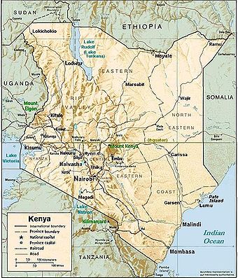
Kenya , officially known as the Republic of Kenya, is a country in East Africa that lies on the equator, with the Indian Ocean to its south-east...
is diverse. Kenya
Kenya
Kenya , officially known as the Republic of Kenya, is a country in East Africa that lies on the equator, with the Indian Ocean to its south-east...
has a coastline on the Indian Ocean
Indian Ocean
The Indian Ocean is the third largest of the world's oceanic divisions, covering approximately 20% of the water on the Earth's surface. It is bounded on the north by the Indian Subcontinent and Arabian Peninsula ; on the west by eastern Africa; on the east by Indochina, the Sunda Islands, and...
, which contains swamps of East African mangroves
East African mangroves
The East African mangroves are an ecoregion consisting of mangrove swamps along the Indian Ocean coast of East Africa in southern Mozambique, Tanzania, Kenya and southern Somalia.-Location and description:...
. Inland are broad plains and numerous hills. Central and Western Kenya is characterized by the Great Rift Valley
Great Rift Valley
The Great Rift Valley is a name given in the late 19th century by British explorer John Walter Gregory to the continuous geographic trench, approximately in length, that runs from northern Syria in Southwest Asia to central Mozambique in South East Africa...
home to three of Africa's highest mountains, Mount Kenya
Mount Kenya
Mount Kenya is the highest mountain in Kenya and the second-highest in Africa, after Kilimanjaro. The highest peaks of the mountain are Batian , Nelion and Point Lenana . Mount Kenya is located in central Kenya, just south of the equator, around north-northeast of the capital Nairobi...
, Mount Elgon
Mount Elgon
Mount Elgon is an extinct shield volcano on the border of Uganda and Kenya, north of Kisumu and west of Kitale.- Physical features :It is the oldest and largest solitary volcano in East Africa, covering an area of around 3500 km²....
and Kilimanjaro. The Kakamega Forest
Kakamega Forest
Kakamega Forest is situated in Western Province Kenya, north-west of the capital Nairobi, and near to the border with Uganda. It is said to be Kenya's last remnant of the ancient Guineo-Congolian rainforest that once spanned the continent....
in western Kenya is relic of an East African rainforest. Much larger is Mau Forest
Mau Forest
Mau Forest is a forest complex in the Rift Valley of Kenya. It is the largest indigenous montane forest in East Africa. The Mau Forest complex has an area of ....
, the largest forest complex in East Africa.
Location
- Eastern AfricaAfricaAfrica is the world's second largest and second most populous continent, after Asia. At about 30.2 million km² including adjacent islands, it covers 6% of the Earth's total surface area and 20.4% of the total land area...
, which is between SomaliaSomaliaSomalia , officially the Somali Republic and formerly known as the Somali Democratic Republic under Socialist rule, is a country located in the Horn of Africa. Since the outbreak of the Somali Civil War in 1991 there has been no central government control over most of the country's territory...
and TanzaniaTanzaniaThe United Republic of Tanzania is a country in East Africa bordered by Kenya and Uganda to the north, Rwanda, Burundi, and the Democratic Republic of the Congo to the west, and Zambia, Malawi, and Mozambique to the south. The country's eastern borders lie on the Indian Ocean.Tanzania is a state... - Geographic coordinates: 1°00′N 38°00′E
Area
- Total: 580367 km² (224,081 sq mi)
- Land: 569140 km² (219,746.2 sq mi)
- Water: 11227 km² (4,334.8 sq mi)
Land boundaries
- Total: 3477 km (2,160.5 mi)
- Border countries: EthiopiaEthiopiaEthiopia , officially known as the Federal Democratic Republic of Ethiopia, is a country located in the Horn of Africa. It is the second-most populous nation in Africa, with over 82 million inhabitants, and the tenth-largest by area, occupying 1,100,000 km2...
861 km (535 mi), SomaliaSomaliaSomalia , officially the Somali Republic and formerly known as the Somali Democratic Republic under Socialist rule, is a country located in the Horn of Africa. Since the outbreak of the Somali Civil War in 1991 there has been no central government control over most of the country's territory...
682 km (423.8 mi), South SudanSouth SudanSouth Sudan , officially the Republic of South Sudan, is a landlocked country located in the Sahel region of northeastern Africa. It is also part of the North Africa UN sub-region. Its current capital is Juba, which is also its largest city; the capital city is planned to be moved to the more...
232 km (144.2 mi), TanzaniaTanzaniaThe United Republic of Tanzania is a country in East Africa bordered by Kenya and Uganda to the north, Rwanda, Burundi, and the Democratic Republic of the Congo to the west, and Zambia, Malawi, and Mozambique to the south. The country's eastern borders lie on the Indian Ocean.Tanzania is a state...
769 km (477.8 mi), UgandaUgandaUganda , officially the Republic of Uganda, is a landlocked country in East Africa. Uganda is also known as the "Pearl of Africa". It is bordered on the east by Kenya, on the north by South Sudan, on the west by the Democratic Republic of the Congo, on the southwest by Rwanda, and on the south by...
933 km (579.7 mi)
Maritime claims
- Continental shelf: 200 m depth or to the depth of exploitation
- Exclusive economic zone: 200 nmi (370.4 km; 230.2 mi)
- Territorial sea: 12 nmi (22.2 km; 13.8 mi)
Geology
The recent geology of western Kenya is dominated by the volcanismVolcanism
Volcanism is the phenomenon connected with volcanoes and volcanic activity. It includes all phenomena resulting from and causing magma within the crust or mantle of a planet to rise through the crust and form volcanic rocks on the surface....
and rift
Rift
In geology, a rift or chasm is a place where the Earth's crust and lithosphere are being pulled apart and is an example of extensional tectonics....
tectonics of the East African Rift
East African Rift
The East African Rift is an active continental rift zone in eastern Africa that appears to be a developing divergent tectonic plate boundary. It is part of the larger Great Rift Valley. The rift is a narrow zone in which the African Plate is in the process of splitting into two new tectonic plates...
. The rift runs north–south from Lake Turkana
Lake Turkana
Lake Turkana , formerly known as Lake Rudolf, is a lake in the Great Rift Valley in Kenya, with its far northern end crossing into Ethiopia. It is the world's largest permanent desert lake and the world's largest alkaline lake...
in the north south past Mount Kenya
Mount Kenya
Mount Kenya is the highest mountain in Kenya and the second-highest in Africa, after Kilimanjaro. The highest peaks of the mountain are Batian , Nelion and Point Lenana . Mount Kenya is located in central Kenya, just south of the equator, around north-northeast of the capital Nairobi...
and Lake Magadi
Lake Magadi
Lake Magadi is the southernmost lake in the Kenya Rift Valley, lying in a catchment of faulted volcanic rocks, north of Tanzania's Lake Natron. During the dry season, it is 80% covered by soda and is well known for its wading birds, including flamingos....
and on to Lake Natron
Lake Natron
Lake Natron is a salt lake located in northern Tanzania, close to the Kenyan border, in the eastern branch of Africa's Great Rift Valley. The lake is fed by the Ewaso Ng'iro River but also by mineral-rich hot springs and is quite shallow, less than three meters deep, and varies in width depending...
and Kilimanjaro in Tanzania
Tanzania
The United Republic of Tanzania is a country in East Africa bordered by Kenya and Uganda to the north, Rwanda, Burundi, and the Democratic Republic of the Congo to the west, and Zambia, Malawi, and Mozambique to the south. The country's eastern borders lie on the Indian Ocean.Tanzania is a state...
.
Much of the western two-thirds of the country underlying the Pliocene
Pliocene
The Pliocene Epoch is the period in the geologic timescale that extends from 5.332 million to 2.588 million years before present. It is the second and youngest epoch of the Neogene Period in the Cenozoic Era. The Pliocene follows the Miocene Epoch and is followed by the Pleistocene Epoch...
–Pleistocene
Pleistocene
The Pleistocene is the epoch from 2,588,000 to 11,700 years BP that spans the world's recent period of repeated glaciations. The name pleistocene is derived from the Greek and ....
volcanics consist of Precambrian
Precambrian
The Precambrian is the name which describes the large span of time in Earth's history before the current Phanerozoic Eon, and is a Supereon divided into several eons of the geologic time scale...
basement rocks. The southeast corner of the country is underlain by sediments of the Karoo System
Karoo System
The Karoo System or Karoo Sequence, is a geologic system of rock formations covering 1 500 000 square km and extending from the Equator south to the Cape of Good Hope...
of Permian
Permian
The PermianThe term "Permian" was introduced into geology in 1841 by Sir Sir R. I. Murchison, president of the Geological Society of London, who identified typical strata in extensive Russian explorations undertaken with Edouard de Verneuil; Murchison asserted in 1841 that he named his "Permian...
to Late Triassic
Late Triassic
The Late Triassic is in the geologic timescale the third and final of three epochs of the Triassic period. The corresponding series is known as the Upper Triassic. In the past it was sometimes called the Keuper, after a German lithostratigraphic group that has a roughly corresponding age...
age and a strip of Jurassic
Jurassic
The Jurassic is a geologic period and system that extends from about Mya to Mya, that is, from the end of the Triassic to the beginning of the Cretaceous. The Jurassic constitutes the middle period of the Mesozoic era, also known as the age of reptiles. The start of the period is marked by...
age sediments along the coast in the Mombasa
Mombasa
Mombasa is the second-largest city in Kenya. Lying next to the Indian Ocean, it has a major port and an international airport. The city also serves as the centre of the coastal tourism industry....
area. The Anza trough
Anza trough
The Anza trough is a rift in Kenya that was formed in the Jurassic Period of the Mesozoic Era.The trough runs inland from the coast in the northwest direction....
is a NW–SE trending Jurassic rift extending from the Indian Ocean
Indian Ocean
The Indian Ocean is the third largest of the world's oceanic divisions, covering approximately 20% of the water on the Earth's surface. It is bounded on the north by the Indian Subcontinent and Arabian Peninsula ; on the west by eastern Africa; on the east by Indochina, the Sunda Islands, and...
coast to the Sudan northwest of Lake Turkana. The Anza Rift resulted from the break–up of Gondwana
Gondwana
In paleogeography, Gondwana , originally Gondwanaland, was the southernmost of two supercontinents that later became parts of the Pangaea supercontinent. It existed from approximately 510 to 180 million years ago . Gondwana is believed to have sutured between ca. 570 and 510 Mya,...
.
Climate
The climate of Kenya varies by location, from mostly cool every day, to always warm/hot. The climate along the coast is tropical. This means rainfall and temperatures are higher throughout the year. At the coastal city MombasaMombasa
Mombasa is the second-largest city in Kenya. Lying next to the Indian Ocean, it has a major port and an international airport. The city also serves as the centre of the coastal tourism industry....
, the air changes from cool to hot, almost every day (see chart below). The further inside Kenya, the more arid the climate becomes. An arid climate is nearly devoid of rainfall, and temperature swings widely according to the general time of the day/night. For many areas of Kenya, the daytime temperature rises about 12 °C (53.6 °F), almost every day.
Elevation is the major factor in temperature levels, with the higher areas, on average, as 11°C (20°F) cooler, day or night. The many mile-high cities have temperature swings from roughly 50–79 °F (10–26.1 C). Nairobi, at 1798 m (5,899 ft) or 1.798 km (1.12 mi), ranges from 49–80 °F (9.4–26.7 C), and Kitale
Kitale
Kitale is an agricultural town in western Kenya situated between Mount Elgon and the Cherengani Hills at an elevation of around . Its urban population was estimated at 220,000 in 2007....
, at 1825 m (5,988 ft) or 1.825 km (1.13 mi), ranges from 51–82 °F (10.6–27.8 C). The overnight lows are not like the "Garden of Eden
Garden of Eden
The Garden of Eden is in the Bible's Book of Genesis as being the place where the first man, Adam, and his wife, Eve, lived after they were created by God. Literally, the Bible speaks about a garden in Eden...
" because, at night, heavy clothes or blankets are needed, in the highlands, when the temperature drops to about 50–54 °F (10–12.2 C) every night.
At lower altitudes, the increased temperature is like day and night, literally: like starting the morning at the highland daytime high, and then adding the heat of the day, again. Hence, the overnight low temperatures near sealevel are nearly the same as the high temperatures of the elevated Kenyan highlands. However, locations along the Indian Ocean have more moderate temperatures, as a few degrees cooler in the daytime, such as at Mombasa
Mombasa
Mombasa is the second-largest city in Kenya. Lying next to the Indian Ocean, it has a major port and an international airport. The city also serves as the centre of the coastal tourism industry....
(see chart below).
There are slight seasonal variations in temperature, of 4 C-change, cooler in the winter months. Although Kenya is centered at the equator
Equator
An equator is the intersection of a sphere's surface with the plane perpendicular to the sphere's axis of rotation and containing the sphere's center of mass....
, it shares the seasons of the southern hemisphere
Southern Hemisphere
The Southern Hemisphere is the part of Earth that lies south of the equator. The word hemisphere literally means 'half ball' or "half sphere"...
: with the warmest summer months in February-March and the coolest winter months in July-August, although only a few degrees cooler.
On the high mountains, such as Mount Kenya
Mount Kenya
Mount Kenya is the highest mountain in Kenya and the second-highest in Africa, after Kilimanjaro. The highest peaks of the mountain are Batian , Nelion and Point Lenana . Mount Kenya is located in central Kenya, just south of the equator, around north-northeast of the capital Nairobi...
, Mount Elgon
Mount Elgon
Mount Elgon is an extinct shield volcano on the border of Uganda and Kenya, north of Kisumu and west of Kitale.- Physical features :It is the oldest and largest solitary volcano in East Africa, covering an area of around 3500 km²....
and Kilimanjaro, the weather can become bitterly cold for most of the year. Some snowfall has occurred on the highest mountains.
| Climate Data for Mombasa (at Indian Ocean) | |||||||||||||||
|---|---|---|---|---|---|---|---|---|---|---|---|---|---|---|---|
| NOAA Code | Statistic | Jan | Feb | Mar | Apr | May | Jun | Jul | Aug | Sep | Oct | Nov | Dec | Avg | |
| 0101 | Temperature Average F |
81.7 | 82.6 | 82.9 | 81.7 | 79.2 | 76.6 | 75.2 | 75.2 | 76.5 | 78.3 | 80.4 | 81.3 | 79.3 | |
| 0201 | Temperature High value F |
91.8 | 92.7 | 92.7 | 90.5 | 87.6 | 84.9 | 83.7 | 83.8 | 85.5 | 86.9 | 88.9 | 91 | 88.3 | |
| 0301 | Temperature Low value F |
71.6 | 72.5 | 73.2 | 72.9 | 70.9 | 68.2 | 66.7 | 66.7 | 67.5 | 69.6 | 71.8 | 71.6 | 70.3 | |
| 0615 | Precipitation in inches |
1.4 | 0.6 | 2.3 | 6.3 | 9.7 | 3.6 | 2.9 | 2.8 | 2.8 | 4.2 | 4.3 | 3.1 | 3.7 | |
| 0101 | Temperature Average C |
27.6 | 28.1 | 28.3 | 27.6 | 26.2 | 24.8 | 24.0 | 24.0 | 24.7 | 25.7 | 26.9 | 27.4 | 26.27 | |
| 0201 | Temperature High value C |
33.2 | 33.7 | 33.7 | 32.5 | 30.9 | 29.4 | 28.7 | 28.8 | 29.7 | 30.5 | 31.6 | 32.8 | 31.29 | |
| 0301 | Temperature Low value C |
22.0 | 22.5 | 22.9 | 22.7 | 21.6 | 20.1 | 19.3 | 19.3 | 19.7 | 20.9 | 22.1 | 22.0 | 21.26 | |
| 0615 | Precipitation in mm |
33.9 | 14.0 | 55.6 | 154.3 | 246 | 88.3 | 71.8 | 68.2 | 67.2 | 103.4 | 104.7 | 75.8 | 89.39 | |
| 1109 | Humidity Maximum % |
76.0 | 76.0 | 78.0 | 82.0 | 85.0 | 84.0 | 86.0 | 85.0 | 82.0 | 81.0 | 80.0 | 78.0 | 81.08 | |
| 1110 | Humidity Minimum % |
62.0 | 59.0 | 61.0 | 66.0 | 70.0 | 67.0 | 67.0 | 66.0 | 65.0 | 66.0 | 68.0 | 65.0 | 65.17 | |
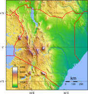
Terrain
Kenya’s terrain is composed of low plains that rise into central highlands that are, in turn, bisected by the Great Rift Valley.Elevation extremes
The lowest point on Kenya is at sea level on the Indian OceanIndian Ocean
The Indian Ocean is the third largest of the world's oceanic divisions, covering approximately 20% of the water on the Earth's surface. It is bounded on the north by the Indian Subcontinent and Arabian Peninsula ; on the west by eastern Africa; on the east by Indochina, the Sunda Islands, and...
. The highest point on Kenya is 5,199 meters above sea level at Mount Kenya
Mount Kenya
Mount Kenya is the highest mountain in Kenya and the second-highest in Africa, after Kilimanjaro. The highest peaks of the mountain are Batian , Nelion and Point Lenana . Mount Kenya is located in central Kenya, just south of the equator, around north-northeast of the capital Nairobi...
.
Rivers
The two main rivers are the GalanaAthi-Galana-Sabaki River
Athi-Galana-Sabaki River is the second longest river in Kenya . It has a total length of 390 km, and drains a basin area of 70,000 km². The river rises at 1° 42' S...
and the Tana
Tana River (Kenya)
The long Tana River is the longest river in Kenya, and gives its name to the Tana River District. Its tributaries include the Thika. The river rises in the Aberdare Mountains to the west of Nyeri. Initially it runs east before turning south around the massif of Mount Kenya. The river then runs...
. However, the Ewaso Ng'iro
Ewaso Ng'iro
Ewaso Ng'iro is a river in Kenya which rises on the west side of Mount Kenya and flows north then east and finally south-east, passing through Somalia where it joins the Jubba River....
is a very important river supplying water from Mt. Kenya to the northern part of Kenya
Kenya
Kenya , officially known as the Republic of Kenya, is a country in East Africa that lies on the equator, with the Indian Ocean to its south-east...
.
Natural resources
Natural resources that are found on Kenya include limestone, soda ash, salt, gemstones, fluorspar, zinc, diatomite, gypsum, wildlife and hydropower.Land use
8.01% of the land is arable. Permanent crops occupy 0.97% of the land. Other uses make up the rest of Kenya's land. (2005)Current issues
Current issues that threaten the environment at the moment include water pollution from urban and industrial wastes; degradation of water quality from the increased use of pesticides and fertilizers; deforestation; soil erosion; desertification and poaching.International agreements
- Party to: BiodiversityBiodiversityBiodiversity is the degree of variation of life forms within a given ecosystem, biome, or an entire planet. Biodiversity is a measure of the health of ecosystems. Biodiversity is in part a function of climate. In terrestrial habitats, tropical regions are typically rich whereas polar regions...
, Climate ChangeUnited Nations Framework Convention on Climate ChangeThe United Nations Framework Convention on Climate Change is an international environmental treaty produced at the United Nations Conference on Environment and Development , informally known as the Earth Summit, held in Rio de Janeiro from June 3 to 14, 1992...
, DesertificationDesertificationDesertification is the degradation of land in drylands. Caused by a variety of factors, such as climate change and human activities, desertification is one of the most significant global environmental problems.-Definitions:...
, Endangered SpeciesEndangered speciesAn endangered species is a population of organisms which is at risk of becoming extinct because it is either few in numbers, or threatened by changing environmental or predation parameters...
, Law of the SeaLaw of the seaLaw of the sea may refer to:* United Nations Convention on the Law of the Sea* Admiralty law* The Custom of the Sea...
, Marine Dumping, Marine Life Conservation, Nuclear Test Ban, Ozone Layer Protection, Ship Pollution (MARPOL 73/78MARPOL 73/78Marpol 73/78 is the International Convention for the Prevention of Pollution From Ships, 1973 as modified by the Protocol of 1978....
), Wetlands, WhalingWhalingWhaling is the hunting of whales mainly for meat and oil. Its earliest forms date to at least 3000 BC. Various coastal communities have long histories of sustenance whaling and harvesting beached whales... - Signed, but not ratified: none of the selected agreements
Extreme points
This is a list of the extreme points of KenyaKenya
Kenya , officially known as the Republic of Kenya, is a country in East Africa that lies on the equator, with the Indian Ocean to its south-east...
, the points that are farther north, south, east or west than any other location.
- Northernmost point - Kalukwakerith mountain, Rift Valley Province*
- Eastern-most point - the tripointTripointA tripoint, or trijunction , is a geographical point at which the borders of three countries or subnational entities meet....
with EthiopiaEthiopiaEthiopia , officially known as the Federal Democratic Republic of Ethiopia, is a country located in the Horn of Africa. It is the second-most populous nation in Africa, with over 82 million inhabitants, and the tenth-largest by area, occupying 1,100,000 km2...
and SomaliaSomaliaSomalia , officially the Somali Republic and formerly known as the Somali Democratic Republic under Socialist rule, is a country located in the Horn of Africa. Since the outbreak of the Somali Civil War in 1991 there has been no central government control over most of the country's territory...
, North Eastern ProvinceNorth Eastern Province (Kenya)North Eastern Province is the third largest province in Kenya and has thirteen constituencies represented in the Kenya National Assembly.The region is home to a rare type of antelope called the Hirola, which is classified as an endangered species. The NFD's pastoralists also possess livestock in... - Southern-most point - the point where the border with TanzaniaTanzaniaThe United Republic of Tanzania is a country in East Africa bordered by Kenya and Uganda to the north, Rwanda, Burundi, and the Democratic Republic of the Congo to the west, and Zambia, Malawi, and Mozambique to the south. The country's eastern borders lie on the Indian Ocean.Tanzania is a state...
enters the Indian OceanIndian OceanThe Indian Ocean is the third largest of the world's oceanic divisions, covering approximately 20% of the water on the Earth's surface. It is bounded on the north by the Indian Subcontinent and Arabian Peninsula ; on the west by eastern Africa; on the east by Indochina, the Sunda Islands, and...
, Coast ProvinceCoast ProvinceCoast Province of Kenya, along the Indian Ocean, is one of Kenya's seven administrative provinces outside Nairobi. It comprises the Indian Ocean coastal strip with the capital city at Mombasa and is inhabited by the Mijikenda and Swahili, among others... - Western-most point - unnamed headland immediately east of Port VictoriaPort VictoriaPort Victoria may refer to several places:* Victoria, Seychelles* Port Victoria, South Australia* Port Victoria, Kenya, a town in Busia District* Port Victoria, Kent, England** Port Victoria railway station, a former railway station in Kent, England...
, Nyanza ProvinceNyanza ProvinceNyanza Province of Kenya, is one of Kenya's eight administrative provinces. It is located in the southwest part of Kenya around Lake Victoria. Nyanza includes part of the eastern edge of Lake Victoria and is inhabited predominantly by the Luo. There are also Bantu-speaking tribes such as the...
- Note: This is including the disputed Ilemi TriangleIlemi TriangleThe Ilemi Triangle is an area of disputed land in East Africa. Arbitrarily defined, it measures between 10,320 and 14,000 square kilometers . Named after Anuak chief Ilemi Akwon, the territory is claimed by South Sudan and Kenya and borders Ethiopia...
region. If this area is excluded then Kenya does not have a northern-most point, the northern border being a straight line
See also
- Environmental issues in KenyaEnvironmental issues in KenyaEnvironmental issues in Kenya include deforestation, soil erosion, desertification, water shortage and degraded water quality, poaching, and domestic and industrial pollution.-Water resources:...
- List of national parks of Kenya
- Ilemi TriangleIlemi TriangleThe Ilemi Triangle is an area of disputed land in East Africa. Arbitrarily defined, it measures between 10,320 and 14,000 square kilometers . Named after Anuak chief Ilemi Akwon, the territory is claimed by South Sudan and Kenya and borders Ethiopia...
- Mandera triangleMandera triangleThe Mandera triangle is a geographical region in Eastern Africa where the countries of Kenya, Ethiopia, and Somalia meet. The tri-border region is centered on the city of Mandera in Kenya's North Eastern Province and corresponds with the Juba and Shabelle river basins.The residents of the area are...