

Geograph British Isles project
Encyclopedia
Web application
A web application is an application that is accessed over a network such as the Internet or an intranet. The term may also mean a computer software application that is coded in a browser-supported language and reliant on a common web browser to render the application executable.Web applications are...
project, initiated in March 2005, to create a freely accessible archive of geographically located photographs of Great Britain
Great Britain
Great Britain or Britain is an island situated to the northwest of Continental Europe. It is the ninth largest island in the world, and the largest European island, as well as the largest of the British Isles...
and Ireland
Ireland
Ireland is an island to the northwest of continental Europe. It is the third-largest island in Europe and the twentieth-largest island on Earth...
.
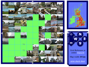
Photographs in the Geograph collection are chosen to illustrate significant or typical features of each 1 km × 1 km (100 hm2
Hectare
The hectare is a metric unit of area defined as 10,000 square metres , and primarily used in the measurement of land. In 1795, when the metric system was introduced, the are was defined as being 100 square metres and the hectare was thus 100 ares or 1/100 km2...
) grid square in the Ordnance Survey National Grid and the Irish national grid reference system
Irish national grid reference system
The Irish grid reference system is a system of geographic grid references commonly used in Ireland . The Irish grid overlaps the British grid.-Usage:...
.
There are 330,184 such grid squares containing at least some land. Each page uses a Geo microformat
Geo (microformat)
Geo is a microformat used for marking up WGS84 geographical coordinates in HTML. Although termed a "draft" specification, this is a formality, and the format is stable and in widespread use; not least as a sub-set of the published hCalendar and hCard microformat specifications, neither of which is...
.
Geographs are being collected for all parts of Great Britain
Great Britain
Great Britain or Britain is an island situated to the northwest of Continental Europe. It is the ninth largest island in the world, and the largest European island, as well as the largest of the British Isles...
and Ireland
Ireland
Ireland is an island to the northwest of continental Europe. It is the third-largest island in Europe and the twentieth-largest island on Earth...
. The Channel Islands
Channel Islands
The Channel Islands are an archipelago of British Crown Dependencies in the English Channel, off the French coast of Normandy. They include two separate bailiwicks: the Bailiwick of Guernsey and the Bailiwick of Jersey...
fall outside Britain's grid system, but may be geographed using their local UTM grid.
The project is sponsored by Ordnance Survey
Ordnance Survey
Ordnance Survey , an executive agency and non-ministerial government department of the Government of the United Kingdom, is the national mapping agency for Great Britain, producing maps of Great Britain , and one of the world's largest producers of maps.The name reflects its creation together with...
, and extracts from the OS Landranger 1:50,000 scale maps illustrate the grid square pages.
Contributions
Photographs can be contributed by any registered user, although they must be approved by a panel of moderators before appearing on the website. The activity of taking photographs for the project is known as geographing. All images are licensed by the contributors using the Creative CommonsCreative Commons
Creative Commons is a non-profit organization headquartered in Mountain View, California, United States devoted to expanding the range of creative works available for others to build upon legally and to share. The organization has released several copyright-licenses known as Creative Commons...
cc-by-sa 2.0 licence which permits modification and redistribution of the images under certain conditions. Contributors should be aware that they are granting everyone an irrevocable licence to use their image(s); it is very difficult to get an image removed once it appears on the website.
The entire archive of images with RDF
Resource Description Framework
The Resource Description Framework is a family of World Wide Web Consortium specifications originally designed as a metadata data model...
metadata is being made available for download via BitTorrent.
As an incentive to increase coverage, participants are awarded a point each time they contribute the first photograph classified as a geograph to a grid square.
There is, however, no limit to the number of images per square, and some squares have over 100. A weekly competition runs in the members-only forums to select the Geograph of the Year from photographs taken that week. The annual winners are "Deer Fence on the Shank of Drumfollow" by Gwen and James Anderson (2008), "Horsey Drainage Mill, Horsey, Norfolk" by Rodney Burton (2007) and "Islands of mud, East Hoyle Bank" by Peter Craine (2006).
Some participants combine geographing with other outdoor location sports such as letterboxing
Letterboxing
Letterboxing is an outdoor hobby that combines elements of orienteering, art, and puzzle solving. Letterboxers hide small, weatherproof boxes in publicly-accessible places and distribute clues to finding the box in printed catalogs, on one of several web sites, or by word of mouth. Individual...
, geocaching
Geocaching
Geocaching is an outdoor sporting activity in which the participants use a Global Positioning System receiver or mobile device and other navigational techniques to hide and seek containers, called "geocaches" or "caches", anywhere in the world....
, trigpointing, benchmarking
Benchmarking (geolocating)
Benchmarking is an activity in which individuals or teams of participants go out and find benchmarks . They typically then log their finds online...
, and peak bagging
Peak bagging
Peak bagging is an activity in which hillwalkers and mountaineers attempt to reach the summit of some collection of peaks, usually those above some height in a particular region, or having a particular feature.Peak bagging can be distinguished from highpointing...
.
Types of image
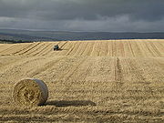

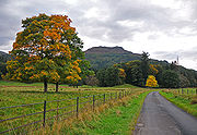
- Geograph – an image which usefully illustrates or characterises the area in which it was taken;
- Supplemental – an image which adds useful information about a square but which does not meet the requirements of a geograph; this includes close-ups, interior, underground and aerial shots, and shots taken from outside the grid square;
- Rejected – an image that does not meet the requirements of the Geograph Project; these are retained by the system but are not visible to anyone other than the owner and the moderators.
There is a special classification of image that is known as First Geograph - the first image uploaded of a particular grid square which meets the requirements to be a geograph; this status is assigned automatically by the system and not by moderators. A new system of points where contributors can gain Second, Third and Fourth points has now been introduced. Similar to the first point system, this time a contributor with gain a point depending on how many other geographers have submitted to that square. For example, a square with one image by one contributor will have second, third and fourth points up for grabs. The same will apply if the first contributor has submitted 100 images in that square. The date the photo was taken makes no difference to the points system. So the next person to submit a geograph will gain a second visit point. The third person to submit will get a third and so on. This was introduced with feedback from members as well as a need to fill up squares will few images.
Some of the common themes for geograph photos include:
- Physical landscapePhysical geographyPhysical geography is one of the two major subfields of geography. Physical geography is that branch of natural science which deals with the study of processes and patterns in the natural environment like the atmosphere, biosphere and geosphere, as opposed to the cultural or built environment, the...
- Human land useLand useLand use is the human use of land. Land use involves the management and modification of natural environment or wilderness into built environment such as fields, pastures, and settlements. It has also been defined as "the arrangements, activities and inputs people undertake in a certain land cover...
- Built environmentBuilt environmentThe term built environment refers to the human-made surroundings that provide the setting for human activity, ranging in scale from personal shelter and buildings to neighborhoods and cities that can often include their supporting infrastructure, such as water supply or energy networks.The built...
- Social interaction
- GeologyGeologyGeology is the science comprising the study of solid Earth, the rocks of which it is composed, and the processes by which it evolves. Geology gives insight into the history of the Earth, as it provides the primary evidence for plate tectonics, the evolutionary history of life, and past climates...
- FloraFloraFlora is the plant life occurring in a particular region or time, generally the naturally occurring or indigenous—native plant life. The corresponding term for animals is fauna.-Etymology:...
and faunaFaunaFauna or faunæ is all of the animal life of any particular region or time. The corresponding term for plants is flora.Zoologists and paleontologists use fauna to refer to a typical collection of animals found in a specific time or place, e.g. the "Sonoran Desert fauna" or the "Burgess shale fauna"... - Local historyLocal historyLocal history is the study of history in a geographically local context and it often concentrates on the local community. It incorporates cultural and social aspects of history...
Statistics
Milestones include:
- 7 August 2010: Saturday Morning the 2 millionth image was submitted.
- 15 October 2008: Millionth image
- 8 April 2008: 750,000 images
- 13 March 2008: Two-thirds coverage of entire British Isles
- 25 July 2007: 500,000 images
- 25 June 2007: 75% coverage of Great Britain
- 30 May 2007: 10% coverage of Ireland
- 5 March 2007: 50% coverage of entire British Isles
- 3 October 2006: 250,000 images
- 17 August 2006: 50% coverage of Great Britain
- 1 March 2006: 25% coverage of entire British Isles
- 21 December 2005: 25% coverage of Great Britain
First Geograph Conference
On Wednesday 17 February 2010, Geograph British Isles organised its first conference for contributors to the project. About 80 contributors attended to discuss the project in both plenary and breakout sessions. The event was hosted by Geograph's sponsor, Ordnance Survey. It took place at the Ordnance Survey head office at Romsey near Southampton and was reported by geography-related media.Long term archival
The site has been selected for long term web archivingWeb archiving
Web archiving is the process of collecting portions of the World Wide Web and ensuring the collection is preserved in an archive, such as an archive site, for future researchers, historians, and the public. Due to the massive size of the Web, web archivists typically employ web crawlers for...
by the British Library
British Library
The British Library is the national library of the United Kingdom, and is the world's largest library in terms of total number of items. The library is a major research library, holding over 150 million items from every country in the world, in virtually all known languages and in many formats,...
in their UK Web Archive.
Sister projects
In 2009, a sister project, Geograph Deutschland was launched, covering GermanyGermany
Germany , officially the Federal Republic of Germany , is a federal parliamentary republic in Europe. The country consists of 16 states while the capital and largest city is Berlin. Germany covers an area of 357,021 km2 and has a largely temperate seasonal climate...
. Geograph Ireland currently co-exists with Geograph British Isles, but may split into a separate project. Geograph Channel Islands covers the Channel Islands
Channel Islands
The Channel Islands are an archipelago of British Crown Dependencies in the English Channel, off the French coast of Normandy. They include two separate bailiwicks: the Bailiwick of Guernsey and the Bailiwick of Jersey...
.