

Geo (microformat)
Encyclopedia
Microformats
A microformat is a web-based approach to semantic markup which seeks to re-use existing HTML/XHTML tags to convey metadata and other attributes in web pages and other contexts that support HTML, such as RSS...
used for marking up WGS84
World Geodetic System
The World Geodetic System is a standard for use in cartography, geodesy, and navigation. It comprises a standard coordinate frame for the Earth, a standard spheroidal reference surface for raw altitude data, and a gravitational equipotential surface that defines the nominal sea level.The latest...
geographical coordinates (latitude
Latitude
In geography, the latitude of a location on the Earth is the angular distance of that location south or north of the Equator. The latitude is an angle, and is usually measured in degrees . The equator has a latitude of 0°, the North pole has a latitude of 90° north , and the South pole has a...
;longitude
Longitude
Longitude is a geographic coordinate that specifies the east-west position of a point on the Earth's surface. It is an angular measurement, usually expressed in degrees, minutes and seconds, and denoted by the Greek letter lambda ....
) in (X)HTML. Although termed a "draft" specification, this is a formality, and the format is stable and in widespread use; not least as a sub-set of the published hCalendar
HCalendar
hCalendar is a microformat standard for displaying a semantic HTML representation of iCalendar-format calendar information about an event, on web pages, using HTML classes and rel attributes....
and hCard
HCard
hCard is a microformat for publishing the contact details of people, companies, organizations, and places, in HTML, Atom, RSS, or arbitrary XML...
microformat specifications, neither of which is still a draft.
Use of Geo allows parsing tools (for example other websites, or Firefox's Operator extension
Operator (extension)
Operator is an extension for the Mozilla Firefox web browser. It parses and acts upon a number of microformats, as well as validating them.Operator lets the user access microformats through a number of methods, all of which are optional: a toolbar, a toolbar button, a status bar icon, a location...
) to extract the locations, and display them using some other website or map
Map
A map is a visual representation of an area—a symbolic depiction highlighting relationships between elements of that space such as objects, regions, and themes....
ping tool, or to load them into a GPS
Global Positioning System
The Global Positioning System is a space-based global navigation satellite system that provides location and time information in all weather, anywhere on or near the Earth, where there is an unobstructed line of sight to four or more GPS satellites...
device, index or aggregate them, or convert them into an alternative format.
Usage
- If latitude is present, so must be longitude, and vice versa.
- The same number of decimal places should be used in each value, including trailing zeroes.Must and should are used per the IETFInternet Engineering Task ForceThe Internet Engineering Task Force develops and promotes Internet standards, cooperating closely with the W3C and ISO/IEC standards bodies and dealing in particular with standards of the TCP/IP and Internet protocol suite...
document RFC 2119
There are two ways to convert ordinary (X)HTML into a geo microformat:
Three classes
Adding three classes. For example the marked-up text:
becomes:
by adding the class-attribute values "geo", "latitude" and "longitude".
This will display
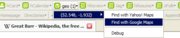
and a geo microformat for that location, Belvide Reservoir
Belvide Reservoir
Belvide Reservoir is a reservoir in South Staffordshire, England. Owned by British Waterways, it was constructed c. 1833 to feed the Birmingham and Liverpool Junction Canal, which is now the Shropshire Union Canal...
, which will be detected, on this page, by microformat parsing tools.
One class
In some cases, a shorthand version may be used, with just the outer class. Latitude must be first:
Belvide Reservoir is at 52.686; -2.193.
becomes:
Belvide Reservoir is at 52.686; -2.193.
Note that the separator must be a semi-colon . If the display of some other separator is desired, then the
abbr element can be used, with the value to be interpreted placed in its title attribute:
Belvide Reservoir is at 52.686, -2.193.
This can also be used to display the location using some other schema:
Belvide Reservoir is at Grid reference SJ870099.
However, it is considered bad practice to use
abbr to hide the location completely:
Belvide Reservoir is nice to visit.
Accessibility concerns
Concerns have been expressed that the use of theabbr element (using the so-called abbr-design-pattern) in the above manner causes accessibility problems, not least for users of screen readers and aural browsers. Work is underway to find an alternative method of presenting coordinates.hCard
Each Geo microformat may be wrapped in an hCardHCard
hCard is a microformat for publishing the contact details of people, companies, organizations, and places, in HTML, Atom, RSS, or arbitrary XML...
microformat, allowing for the inclusion of personal, organisational or venue names, postal addresses, telephone contacts, URL
Uniform Resource Locator
In computing, a uniform resource locator or universal resource locator is a specific character string that constitutes a reference to an Internet resource....
s, pictures, etc.
Extensions
There are three active proposals, none mutually-exclusive, to extend the geo microformat:- geo-extension - for representing coordinates on other planets, moons etc., and with non-WGS84 schema
- geo-elevation - for representing altitude
- geo-waypoint - for representing routes and boundaries, using waypoints
Users
Organisations and websites using Geo include:- FlickrFlickrFlickr is an image hosting and video hosting website, web services suite, and online community that was created by Ludicorp in 2004 and acquired by Yahoo! in 2005. In addition to being a popular website for users to share and embed personal photographs, the service is widely used by bloggers to...
- on over three million photo pages - Geograph British Isles - on over one million photo pages
- GoogleGoogleGoogle Inc. is an American multinational public corporation invested in Internet search, cloud computing, and advertising technologies. Google hosts and develops a number of Internet-based services and products, and generates profit primarily from advertising through its AdWords program...
- MultimapMultimap.comMultimap.com was a United Kingdom based provider of mapping and location-based services. It was acquired by Microsoft in 2007 and merged into Bing Maps in 2010.-History:...
- all map pages - MyMap - example: http://mymap.yam.com/place/point/charleschuang/6695/ (Taiwanese language site)
- OpenStreetMapOpenStreetMapOpenStreetMap is a collaborative project to create a free editable map of the world. Two major driving forces behind the establishment and growth of OSM have been restrictions on use or availability of map information across much of the world and the advent of inexpensive portable GPS devices.The...
- wiki pages about places, GPS traces and diary entries - The West Midland Bird Club
- Locify - location enhanced browsing on mobile phone
- WikipediaWikipediaWikipedia is a free, web-based, collaborative, multilingual encyclopedia project supported by the non-profit Wikimedia Foundation. Its 20 million articles have been written collaboratively by volunteers around the world. Almost all of its articles can be edited by anyone with access to the site,...
- embedded in geo templates of map-link pages- German WikipediaGerman WikipediaThe German Wikipedia is the German-language edition of Wikipedia, a free and mostly publicly editable online encyclopedia.Founded in March 2001, it is the second-oldest and, with over articles, the second-largest edition of Wikipedia, behind the English Wikipedia...
- ditto - Dutch WikipediaDutch WikipediaThe Dutch Wikipedia is the Dutch-language edition of the free online encyclopedia, Wikipedia. As of November 2011, the Dutch Wikipedia is the fourth-largest Wikipedia edition, with over articles.-History:...
- ditto - Swedish WikipediaSwedish WikipediaThe Swedish Wikipedia is the Swedish language edition of Wikipedia. It was the third edition of Wikipedia, started in May 2001 alongside German Wikipedia, after English Wikipedia and Catalan Wikipedia...
- ditto - Italian WikipediaItalian WikipediaThe Italian Wikipedia is the Italian-language edition of Wikipedia. This edition was created on May 11, 2001 and first edited on June 11, 2001. As of 2011 it has over articles and more than registered accounts...
- German Wikipedia
- WikitravelWikitravel-External links:* *...
Many of the organisations publishing hCard include a geo as part of that.
External links
- Geo spec with notes and examples
- Geo cheat-sheet a quick reference