
GeoNetwork opensource
Encyclopedia
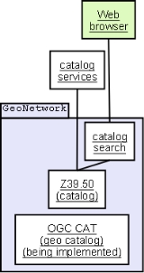
The GeoNetwork opensource project is a free and open source
cataloging application for spatially referenced resources. It is a catalog of location-oriented information.
products and related metadata
from a variety of sources, enhancing the spatial information exchange and sharing between organizations and their audience, using the capacities of the internet. Using the Z39.50
protocol it both accesses remote catalogs and makes its data available to other catalog services. As of 2007, OGC
Web Catalog Service
are being implemented.
Maps
, including those derived from satellite imagery
, are effective communicational tools and play an important role in the work of decision makers (e.g., sustainable development planners and humanitarian and emergency managers) in need of quick, reliable and up-to-date user-friendly cartographic products as a basis for action and to better plan and monitor their activities; GIS experts in need of exchanging consistent and updated geographical data; and spatial analysts
in need of multidisciplinary
data to perform preliminary geographical analysis and make reliable forecasts.
, Italy
. Furthermore, the WHO
, CGIAR, BRGM, ESA, FGDC and the Global Change Information and Research Centre (GCIRC) of China are working on GeoNetwork opensource implementations as their spatial information management capacity.
Several related tools are packaged with GeoNetwork, including GeoServer
. GeoServer stores geographical data, while GeoNetwork catalogs collections of such data.
Free software
Free software, software libre or libre software is software that can be used, studied, and modified without restriction, and which can be copied and redistributed in modified or unmodified form either without restriction, or with restrictions that only ensure that further recipients can also do...
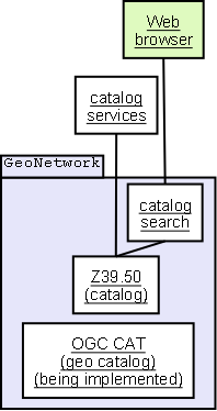
cataloging application for spatially referenced resources. It is a catalog of location-oriented information.
Outline
It is a standardized and decentralized spatial information management environment designed to enable access to geo-referenced databases, cartographicCartography
Cartography is the study and practice of making maps. Combining science, aesthetics, and technique, cartography builds on the premise that reality can be modeled in ways that communicate spatial information effectively.The fundamental problems of traditional cartography are to:*Set the map's...
products and related metadata
Metadata
The term metadata is an ambiguous term which is used for two fundamentally different concepts . Although the expression "data about data" is often used, it does not apply to both in the same way. Structural metadata, the design and specification of data structures, cannot be about data, because at...
from a variety of sources, enhancing the spatial information exchange and sharing between organizations and their audience, using the capacities of the internet. Using the Z39.50
Z39.50
Z39.50 is a client–server protocol for searching and retrieving information from remote computer databases. It is covered by ANSI/NISO standard Z39.50, and ISO standard 23950. The standard's maintenance agency is the Library of Congress....
protocol it both accesses remote catalogs and makes its data available to other catalog services. As of 2007, OGC
Open Geospatial Consortium
The Open Geospatial Consortium , an international voluntary consensus standards organization, originated in 1994. In the OGC, more than 400 commercial, governmental, nonprofit and research organizations worldwide collaborate in a consensus process encouraging development and implementation of open...
Web Catalog Service
Web Catalog Service
The OGC Catalog Service defines common interfaces to discover, browse, and query metadata about data, services, and other potential resources.Web Catalog Service includes several profiles including Catalog Service - Web.-See also:*Web Map Service...
are being implemented.
Maps
MAPS
Maps is the plural of map, a visual representation of an area.As an acronym, MAPS may refer to:* Mail Abuse Prevention System, an organisation that provides anti-spam support...
, including those derived from satellite imagery
Satellite imagery
Satellite imagery consists of photographs of Earth or other planets made by means of artificial satellites.- History :The first images from space were taken on sub-orbital flights. The U.S-launched V-2 flight on October 24, 1946 took one image every 1.5 seconds...
, are effective communicational tools and play an important role in the work of decision makers (e.g., sustainable development planners and humanitarian and emergency managers) in need of quick, reliable and up-to-date user-friendly cartographic products as a basis for action and to better plan and monitor their activities; GIS experts in need of exchanging consistent and updated geographical data; and spatial analysts
Spatial analysis
Spatial analysis or spatial statistics includes any of the formal techniques which study entities using their topological, geometric, or geographic properties...
in need of multidisciplinary
Interdisciplinarity
Interdisciplinarity involves the combining of two or more academic fields into one single discipline. An interdisciplinary field crosses traditional boundaries between academic disciplines or schools of thought, as new needs and professions have emerged....
data to perform preliminary geographical analysis and make reliable forecasts.
Deployment
The software has been deployed to various organizations, the first being FAO GeoNetwork and WFP VAM-SIE-GeoNetwork, both at their headquarters in RomeRome
Rome is the capital of Italy and the country's largest and most populated city and comune, with over 2.7 million residents in . The city is located in the central-western portion of the Italian Peninsula, on the Tiber River within the Lazio region of Italy.Rome's history spans two and a half...
, Italy
Italy
Italy , officially the Italian Republic languages]] under the European Charter for Regional or Minority Languages. In each of these, Italy's official name is as follows:;;;;;;;;), is a unitary parliamentary republic in South-Central Europe. To the north it borders France, Switzerland, Austria and...
. Furthermore, the WHO
Who
Who may refer to:* Who , an English-language pronoun* who , a Unix command* Who?, one of the Five Ws in journalism- Art and entertainment :* Who? , a 1958 novel by Algis Budrys...
, CGIAR, BRGM, ESA, FGDC and the Global Change Information and Research Centre (GCIRC) of China are working on GeoNetwork opensource implementations as their spatial information management capacity.
Several related tools are packaged with GeoNetwork, including GeoServer
GeoServer
In computing, GeoServer - an open-source server written in Java - allows users to share and edit geospatial data. Designed for interoperability, it publishes data from any major spatial data source using open standards...
. GeoServer stores geographical data, while GeoNetwork catalogs collections of such data.
See also
{|align=left|- Open Source Geospatial FoundationOpen Source Geospatial FoundationThe Open Source Geospatial Foundation , is a non-profit non-governmental organization whose mission is to support and promote the collaborative development of open geospatial technologies and data. The foundation was formed in February 2006 to provide financial, organizational and legal support to...
- List of GIS software
- List of open source software packages
- Comparison of GIS softwareComparison of GIS softwareThis is a comparison of notable GIS software. To be included on this list, the software must either have a linked existing article or include references to independent sources verifying notability.-License, source, & operating system support:-Map servers:...