
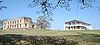
Fort Washita
Encyclopedia
Fort Washita is the former United States
military post
and National Historic Landmark
located near Nida, Oklahoma
on SH 199. Established in 1842 by General
(later President
) Zachary Taylor
to protect citizens of the Choctaw
and Chickasaw
Nations from the plains indians
it was later abandoned by Federal forces at the beginning of the American Civil War
. Confederate
troops held the post until the end of the war when they burned the remaining structures. It was never reoccupied by the United States military. After years in private hands the Oklahoma Historical Society
bought the fort grounds in 1962 and restored the site. Today the Fort Washita Historic Site and Museum is a tourist attraction and hosts several events throughout the year.
 France
was the first European power to claim the region Fort Washita lies within. La Salle
explored the Mississippi River
in 1682 and claimed all the lands it drained for France. After the Seven Years' War
France ceded the area to Spain. France regained the area with the Treaty of San Ildefonso
in 1800. The United States purchased the area from France in 1803 with the Louisiana Purchase
. The Adams-Onís Treaty
of 1819 fixed a portion of the border between the United States and New Spain
as the Red River
.
in the southern United States the Federal government passed the Indian Removal Act
into law on May 26, 1830. The first of the Indians to be removed, the Choctaws, signed the Treaty of Dancing Rabbit Creek
on September 27, 1830 effectively ceding their native lands in Mississippi and Alabama to the United States in exchange for lands in the Indian Territory. After traveling on the Choctaw Trail of Tears
the Choctaws settled in the new Choctaw Nation, the southern part of the Indian Territory bordering the Red River.
The Cross Timbers
, a thick line of nearly impassable trees and brush running from north to south, created an effective east-west barrier separating the flat, dry lands inhabited by the plains Indians to the west from the rolling prairies to the east where the Five Civilized Tribes were locating. These indigenous tribes included the Commanches, Wichita
, Caddo
es, and Kiowa
. They occasionally threatened the removed tribes with raids. The Choctaws mostly settled in the eastern part of their territory since the western end was less secure against raids from the plains Indians, and they had protection from federal troops located at Fort Towson
.
Captain T. A. Blake led a company of Dragoons from Fort Towson to the site of Fort Washita in late 1841.
and 18 miles north of its junction with the Red River
. At the time the Red River was the southern border of the Indian Territory with new Republic of Texas
. The fort was surrounded by rolling prairie. The nearest military post at this time was Fort Towson 80 miles to the east.
Fort Washita sat at a strategic point on the frontier. In addition to being located near the Red and Washita rivers there existed an ancient north-south trail through the area. In the Indian Territory this route was known as the Texas Road
, leading from Missouri to Texas and beyond. This route was called the old Preston Trail
after it crossed into Texas on the Red River near Preston Bend
at Coffee's Trading Post and later Colbert's Ferry
. Fort Washita became a major junction on this road. Later the Shawnee Cattle Trail
used this north-south route and, just prior to the Civil War, the Butterfield Overland Stage crossed just east of Fort Washita.
Fort Washita was connected to Fort Towson and Fort Gibson by military roads constructed earlier. Later military roads connected Fort Washita with forts Arbuckle
and Sill
.
The Cross Timbers were located near Fort Washita, about 19 miles west of the Washita River.
 Construction at Fort Washita began in the spring of 1842. The Chickasaw Indian Agency was built early on as a one-story log building with four rooms in a group of trees on the edge of the prairie 600 yards west of Fort Washita near the springs. Construction was carried out mostly by Companies A and F of the Second Dragoons, with a temporary log barracks in 1842. There were supply difficulties, since the fort was located so far on the frontier. Most materials had to be taken from the area, with a few supplies being shipped from Fort Towson.
Troops from Fort Washita were ordered to protect Texas frontier from Indian attacks in 1842 so Texans could muster against a supposed invasion from Mexico.
Fort Washita was almost abandoned in 1843 before it was fully occupied. General Taylor learned in March 1843 that the War Department was considering abandoning it. After Taylor testified to the fort's valuable location the War Department approved the plans to occupy the fort, and the United States Army occupied the post on April 23, 1843.
Bean Starr, one of the Starr gang, died at the hospital at Fort Washita after being wounded at a shootout on the Washita River 25 miles above the fort in the Autumn of 1844.
Had corral, stable area, blacksmith, farrier shops.
In 1845 Fort Washita was the only frontier fort not accessible by steamboat and had to rely on the interior for its supply.
 When the Mexican-American War began in May 1846 activity increased dramatically at Fort Washita. As a United State military post near Texas the fort served as a staging point for the war. Traffic on the Texas Road heading south increased during and after the war. During the war years the average garrison of 150 troops increased to almost 2000 troops. During this era Fort Washita served as the site of the Choctaw and Chickasaw Indian Agencies
. The Mexican-American War ended with the Treaty of Guadalupe Hidalgo, signed on February 2, 1848.
The Chickasaws met at Boiling Spring near Fort Washita in 1846 and adopted a constitution. They met again at Boiling Spring on October 13, 1848 and created a more formal constitution, creating their own government separate from the Choctaws. As the Chickawsaws moved into their own country near and west of Fort Washita they increasing needed protection from the fort against the plains Indians.
The temporary log barracks was replaced after the construction of the south barracks from limestone
in 1849.
Commanded by Dixon S. Miles
in late 1849 and early 1851.
Major Daniel Ruggles
served at Fort Washita from 1849 to 1851 after the Mexican-American War and eventually commanded the fort. He was popular, and the small settlement west of the fort was named Rugglesville after him. It was sometimes called Rucklesville and later Hatsboro.
Shortly after the Mexican-American War the 2nd Artillery Regiment, commanded by Colonel Braxton Bragg
and made famous at the Battle of Buena Vista
, was assigned to the fort. Bragg was later a General in the Confederate Army.
Fort Worth was established June 6, 1849. The distance between Fort Worth and Fort Washita is 120 miles.
General Belknap, commander of Fort Arbuckle died on November 10, 1851 on an ambulance between Preston, Texas and Fort Washita bound for Fort Gibson to see his family. He was interred at Fort Washita.
The headquarters of the Seventh Military Department was transferred to Fort Washita in 1853. With it Major T. H Holmes commanded the fort. Only one light battery of artillery was assigned to the post in 1853.
The west barracks was built in 1856 from native limestone.
The two artillery batteries at Fort Washita were transferred to Fort Monroe, leaving on December 25, 1856.
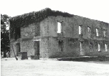
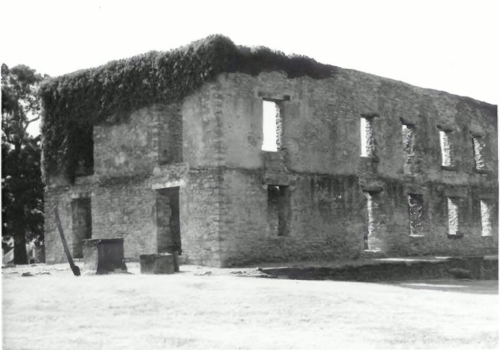
By 1858 there was an east barracks, hospital, and surgeon's quarters all built from native stone, in addition to the wooden structures. A corral and stables on the hillside southwest of the fort supported cavalry operations. Cavalry
comprised the bulk of the forces assigned to Fort Washita until the 1850s when it served as a United States Army Field Artillery
School. Several Artillery units were assigned to the fort during this time in addition to infantry and cavalry. Forts Smith, Washita, Belknap and Arbuckle were abandoned temporarily in 1858 so their troops could be sent to Utah during the Utah War
. The Fort closed on February 17, 1858 but was reoccupied later that year on December 29 after increased Comanche activity.
Fort Washita's importance as a military post waned as the frontier moved westward. The Chickasaw and Choctaw nations grew more settled and incursions by the plains Indians lessened. As the frontier moved westward new military posts were established farther west to protect the new frontier. The Army established Fort Cobb in October 1859.
 Many men who served at Fort Washita would go on to become famous, including Randolph B. Marcy
, George McClellan
, William G. Belknap and Theophilus H. Holmes
.
militia one day behind them. Afterwards the Confederate forces seized Fort Washita. The Five Civilized Tribes
of the Indian Territory sided with the Confederacy. During the Civil War Fort Washita saw no action, though it was an important supply depot for the Confederates in the Indian Territory. It also served as military hospital. Fort Washita became the headquarters of Brigadier General Douglas Cooper
, who assumed command after the battle of Honey Springs. Other Confederate commanders during the Civil War include General Albert Pike
, served as commander of Fort Washita for a short time before establishing Fort McCulloch
a few miles to the east, and General Stand Watie
. Near the end of the war in August 1865 Confederate forces burned the existing buildings and abandoned the post. A confederate cemetery remains to this day on the fort grounds. United States military graves were exhumed and reinterred at Fort Gibson near Muskogee, Oklahoma
.
handed over the fort grounds to the Department of the Interior. The passage of the Dawes Act
in 1887 and the Atoka Agreement
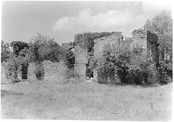
in 1897 divided the communal lands of the Chickasaw Nation, including Fort Washita, into allotments owned by individual Chickasaw citizens. The Colberts, a prominent Chickasaw family, received the allotment of grounds including the fort. Department of Interior turned land over to Abbie Davis Colbert and her son. Charles Colbert turned the existing east barracks into a personal home and the site was used as a farm for many years. The remaining buildings were used in a farming capacity. The Colberts also used the cemetery as a family cemetery. The old west barracks continued to serve as the Colberts' household until it burned down in 1917.
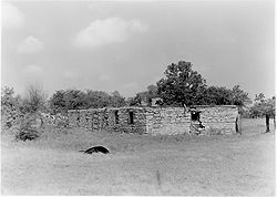
 In the 1960s there was a renewed interest in Oklahoma's Historical Sites. The Oklahoma Historical Society was able to determine that at the Fort Washita site there were 86 structures, 50 foundations and 2 structures still standing.
Ward S. Merrick Sr. of Ardmore, Oklahoma
contributed funds to the Oklahoma Historical Society for the purchase of the site from the Colbert family in 1962. At the time, William "Buck" Loper and his wife, Lela, lived in the current park headquarters. During the sale of the property to the Historical Society, the Colberts allowed the Lopers to stay until their death around 1963. They are both buried in the fort cemetery. It was declared a National Historic Landmark in 1965 and in 1967 the Oklahoma State Legislature approved $10,000 for the reconstruction and restoration of the fort's grounds. In 1971 the Oklahoma Historical Society conducted an archeological dig and rebuilt the south barracks.
Today the Fort Washita site is home to Fort Washita Historic Site and Museum, Civil War reenactments
, and a yearly Fur Trade Rendezvous.
On September 26, 2010, the reconstructed South Barracks was destroyed by fire.
United States
The United States of America is a federal constitutional republic comprising fifty states and a federal district...
military post
Military base
A military base is a facility directly owned and operated by or for the military or one of its branches that shelters military equipment and personnel, and facilitates training and operations. In general, a military base provides accommodations for one or more units, but it may also be used as a...
and National Historic Landmark
National Historic Landmark
A National Historic Landmark is a building, site, structure, object, or district, that is officially recognized by the United States government for its historical significance...
located near Nida, Oklahoma
Nida, Oklahoma
Nida is an unincorporated community in Johnston County, Oklahoma, United States, along State Highway 22. It is the nearest community to Fort Washita, a National Historic Landmark....
on SH 199. Established in 1842 by General
General
A general officer is an officer of high military rank, usually in the army, and in some nations, the air force. The term is widely used by many nations of the world, and when a country uses a different term, there is an equivalent title given....
(later President
President of the United States
The President of the United States of America is the head of state and head of government of the United States. The president leads the executive branch of the federal government and is the commander-in-chief of the United States Armed Forces....
) Zachary Taylor
Zachary Taylor
Zachary Taylor was the 12th President of the United States and an American military leader. Initially uninterested in politics, Taylor nonetheless ran as a Whig in the 1848 presidential election, defeating Lewis Cass...
to protect citizens of the Choctaw
Choctaw
The Choctaw are a Native American people originally from the Southeastern United States...
and Chickasaw
Chickasaw
The Chickasaw are Native American people originally from the region that would become the Southeastern United States...
Nations from the plains indians
Plains Indians
The Plains Indians are the Indigenous peoples who live on the plains and rolling hills of the Great Plains of North America. Their colorful equestrian culture and resistance to White domination have made the Plains Indians an archetype in literature and art for American Indians everywhere.Plains...
it was later abandoned by Federal forces at the beginning of the American Civil War
American Civil War
The American Civil War was a civil war fought in the United States of America. In response to the election of Abraham Lincoln as President of the United States, 11 southern slave states declared their secession from the United States and formed the Confederate States of America ; the other 25...
. Confederate
Confederate States of America
The Confederate States of America was a government set up from 1861 to 1865 by 11 Southern slave states of the United States of America that had declared their secession from the U.S...
troops held the post until the end of the war when they burned the remaining structures. It was never reoccupied by the United States military. After years in private hands the Oklahoma Historical Society
Oklahoma Historical Society
The Oklahoma Historical Society is an agency of the government of Oklahoma dedicated to promotion and preservation of Oklahoma's history and its people by collecting, interpreting, and disseminating knowledge and artifacts of Oklahoma....
bought the fort grounds in 1962 and restored the site. Today the Fort Washita Historic Site and Museum is a tourist attraction and hosts several events throughout the year.
Location
France
The French Republic , The French Republic , The French Republic , (commonly known as France , is a unitary semi-presidential republic in Western Europe with several overseas territories and islands located on other continents and in the Indian, Pacific, and Atlantic oceans. Metropolitan France...
was the first European power to claim the region Fort Washita lies within. La Salle
René-Robert Cavelier, Sieur de La Salle
René-Robert Cavelier, Sieur de La Salle, or Robert de LaSalle was a French explorer. He explored the Great Lakes region of the United States and Canada, the Mississippi River, and the Gulf of Mexico...
explored the Mississippi River
Mississippi River
The Mississippi River is the largest river system in North America. Flowing entirely in the United States, this river rises in western Minnesota and meanders slowly southwards for to the Mississippi River Delta at the Gulf of Mexico. With its many tributaries, the Mississippi's watershed drains...
in 1682 and claimed all the lands it drained for France. After the Seven Years' War
Seven Years' War
The Seven Years' War was a global military war between 1756 and 1763, involving most of the great powers of the time and affecting Europe, North America, Central America, the West African coast, India, and the Philippines...
France ceded the area to Spain. France regained the area with the Treaty of San Ildefonso
Treaty of San Ildefonso
San Ildefonso is a town in central Spain, the summer residence of the Kings of Spain, where several treaties were signed; each is referred to, in context, as the Treaty of San Ildefonso...
in 1800. The United States purchased the area from France in 1803 with the Louisiana Purchase
Louisiana Purchase
The Louisiana Purchase was the acquisition by the United States of America of of France's claim to the territory of Louisiana in 1803. The U.S...
. The Adams-Onís Treaty
Adams-Onís Treaty
The Adams–Onís Treaty of 1819, also known as the Transcontinental Treaty or the Purchase of Florida, was a treaty between the United States and Spain in 1819 that gave Florida to the U.S. and set out a boundary between the U.S. and New Spain . It settled a standing border dispute between the two...
of 1819 fixed a portion of the border between the United States and New Spain
New Spain
New Spain, formally called the Viceroyalty of New Spain , was a viceroyalty of the Spanish colonial empire, comprising primarily territories in what was known then as 'América Septentrional' or North America. Its capital was Mexico City, formerly Tenochtitlan, capital of the Aztec Empire...
as the Red River
Red River (Mississippi watershed)
The Red River, or sometimes the Red River of the South, is a major tributary of the Mississippi and Atchafalaya Rivers in the southern United States of America. The river gains its name from the red-bed country of its watershed. It is one of several rivers with that name...
.
Five Civilized Tribes removed to the Indian Territory
Eager to gain access to the lands of the Five Civilized TribesFive Civilized Tribes
The Five Civilized Tribes were the five Native American nations—the Cherokee, Chickasaw, Choctaw, Creek, and Seminole—that were considered civilized by Anglo-European settlers during the colonial and early federal period because they adopted many of the colonists' customs and had generally good...
in the southern United States the Federal government passed the Indian Removal Act
Indian Removal Act
The Indian Removal Act was signed into law by President Andrew Jackson on May 28, 1830.The Removal Act was strongly supported in the South, where states were eager to gain access to lands inhabited by the Five Civilized Tribes. In particular, Georgia, the largest state at that time, was involved in...
into law on May 26, 1830. The first of the Indians to be removed, the Choctaws, signed the Treaty of Dancing Rabbit Creek
Treaty of Dancing Rabbit Creek
The Treaty of Dancing Rabbit Creek was a treaty signed on September 27, 1830 between the Choctaw and the United States Government. This was the first removal treaty carried into effect under the Indian Removal Act...
on September 27, 1830 effectively ceding their native lands in Mississippi and Alabama to the United States in exchange for lands in the Indian Territory. After traveling on the Choctaw Trail of Tears
Choctaw Trail of Tears
The Choctaw Trail of Tears was the relocation of the Choctaw Nation from their country referred to now as the Deep South to lands west of the Mississippi River in Indian Territory in the 1830s...
the Choctaws settled in the new Choctaw Nation, the southern part of the Indian Territory bordering the Red River.
The Cross Timbers
Cross Timbers
The term Cross Timbers is used to describe a strip of land in the United States that runs from southeastern Kansas across Central Oklahoma to Central Texas...
, a thick line of nearly impassable trees and brush running from north to south, created an effective east-west barrier separating the flat, dry lands inhabited by the plains Indians to the west from the rolling prairies to the east where the Five Civilized Tribes were locating. These indigenous tribes included the Commanches, Wichita
Wichita (tribe)
The Wichita people are indigenous inhabitants of North America, who traditionally spoke the Wichita language, a Caddoan language. They have lived in Kansas, Oklahoma, and Texas...
, Caddo
Caddo
The Caddo Nation is a confederacy of several Southeastern Native American tribes, who traditionally inhabited much of what is now East Texas, northern Louisiana and portions of southern Arkansas and Oklahoma. Today the Caddo Nation of Oklahoma is a cohesive tribe with its capital at Binger, Oklahoma...
es, and Kiowa
Kiowa
The Kiowa are a nation of American Indians and indigenous people of the Great Plains. They migrated from the northern plains to the southern plains in the late 17th century. In 1867, the Kiowa moved to a reservation in southwestern Oklahoma...
. They occasionally threatened the removed tribes with raids. The Choctaws mostly settled in the eastern part of their territory since the western end was less secure against raids from the plains Indians, and they had protection from federal troops located at Fort Towson
Fort Towson
Fort Towson was a frontier outpost for Frontier Army Quartermasters along the Permanent Indian Frontier located about two miles northeast of the present community of Fort Towson, Oklahoma....
.
Dodge-Leavenworth Expedition
The first official contact between the United States and the plains Indians was during the Dodge-Leavenworth Expedition in 1834. Camp Washita, the precursor to Fort Washita, was established near the mouth of the Washita River to serve as a base of operations for the area. Two roads were cleared to the area, one from Fort Gibson to the north and one to Fort Towson to the east. Camp Washita was abandoned later that year.Chickasaw removal
The Chickasaws were removed to the Indian Territory in 1837, paying $530,000 to the Choctaws for the right to live in their lands. After removal to the Indian Territory the Chickasaws were reluctant to settle in their district, composed of the west and central area of the Choctaw lands. The area was not secure against the plains Indians, since the closest federal garrison, at Fort Towson, was too far away to protect the area effectively. In 1838 the Superintendent of Indian Affairs for the Western Territory, William Armstrong, asked the War Department to build a military post near the mouth of the Washita River to secure the area so the Chickasaws could move into their assigned territory.Captain T. A. Blake led a company of Dragoons from Fort Towson to the site of Fort Washita in late 1841.
Location and construction
In response to the need to defend the removed Indians on the frontier the United States Army authorized the construction of a fort on the Choctaw lands west of Fort Towson. General Zachary Taylor, as commander of the Second Military Department in the Southwest, chose the site for Fort Washita in 1842 on high ground a mile and a half east of the Washita RiverWashita River
The Washita River is a river in Texas and Oklahoma, United States. The river is long and terminates into Lake Texoma in Johnston County , Oklahoma and the Red River.-Geography:...
and 18 miles north of its junction with the Red River
Red River (Mississippi watershed)
The Red River, or sometimes the Red River of the South, is a major tributary of the Mississippi and Atchafalaya Rivers in the southern United States of America. The river gains its name from the red-bed country of its watershed. It is one of several rivers with that name...
. At the time the Red River was the southern border of the Indian Territory with new Republic of Texas
Republic of Texas
The Republic of Texas was an independent nation in North America, bordering the United States and Mexico, that existed from 1836 to 1846.Formed as a break-away republic from Mexico by the Texas Revolution, the state claimed borders that encompassed an area that included all of the present U.S...
. The fort was surrounded by rolling prairie. The nearest military post at this time was Fort Towson 80 miles to the east.
Fort Washita sat at a strategic point on the frontier. In addition to being located near the Red and Washita rivers there existed an ancient north-south trail through the area. In the Indian Territory this route was known as the Texas Road
Texas Road
The Texas Road, also known as the Shawnee Trail, was a major trade and emigrant route across Texas, Indian Territory Oklahoma, Kansas and Missouri. It was the first Texas North South Cattle Drive...
, leading from Missouri to Texas and beyond. This route was called the old Preston Trail
Preston Trail
Preston Trail, later known as the Old Preston Road, was a road created by the Republic of Texas in 1841 from Preston, Texas on the Red River south to Austin, Texas. This road closely followed an existing trail that led across the area that had been used for centuries...
after it crossed into Texas on the Red River near Preston Bend
Preston, Texas
Preston, Texas, also known as Preston Bend was a prominent town located on the Red River in North Texas. It grew in the 19th century at the intersection of several military and trade roads and was an important crossing on the Shawnee cattle trail. Preston lost prominence after the MK&T railroad...
at Coffee's Trading Post and later Colbert's Ferry
Colbert's Ferry
Colbert's Ferry was an important Red River crossing between Texas and Indian Territory from about 1850 to 1899. Both the Texas Road and the Butterfield Overland Mail route crossed here. It was located about a half mile southeast of present–day Colbert, Oklahoma.Benjamin F...
. Fort Washita became a major junction on this road. Later the Shawnee Cattle Trail
Shawnee Trail
Shawnee Trail may refer to:* Shawnee Trail , a portion of the larger Great Indian Warpath or Seneca Trail* Texas Road, a pioneer cattle trail, once known as Shawnee Trail...
used this north-south route and, just prior to the Civil War, the Butterfield Overland Stage crossed just east of Fort Washita.
Fort Washita was connected to Fort Towson and Fort Gibson by military roads constructed earlier. Later military roads connected Fort Washita with forts Arbuckle
Fort Arbuckle
Not to be confused with Old Fort Arbuckle , a site in Tulsa County, Oklahoma.Fort Arbuckle was a United States military fort near Hoover, Oklahoma....
and Sill
Fort Sill
Fort Sill is a United States Army post near Lawton, Oklahoma, about 85 miles southwest of Oklahoma City.Today, Fort Sill remains the only active Army installation of all the forts on the South Plains built during the Indian Wars...
.
The Cross Timbers were located near Fort Washita, about 19 miles west of the Washita River.
Troops from Fort Washita were ordered to protect Texas frontier from Indian attacks in 1842 so Texans could muster against a supposed invasion from Mexico.
Fort Washita was almost abandoned in 1843 before it was fully occupied. General Taylor learned in March 1843 that the War Department was considering abandoning it. After Taylor testified to the fort's valuable location the War Department approved the plans to occupy the fort, and the United States Army occupied the post on April 23, 1843.
Bean Starr, one of the Starr gang, died at the hospital at Fort Washita after being wounded at a shootout on the Washita River 25 miles above the fort in the Autumn of 1844.
Had corral, stable area, blacksmith, farrier shops.
In 1845 Fort Washita was the only frontier fort not accessible by steamboat and had to rely on the interior for its supply.
The Mexican-American War
Indian agent
In United States history, an Indian agent was an individual authorized to interact with Native American tribes on behalf of the U.S. government.-Indian agents:*Leander Clark was agent for the Sac and Fox in Iowa beginning in 1866....
. The Mexican-American War ended with the Treaty of Guadalupe Hidalgo, signed on February 2, 1848.
The Chickasaws met at Boiling Spring near Fort Washita in 1846 and adopted a constitution. They met again at Boiling Spring on October 13, 1848 and created a more formal constitution, creating their own government separate from the Choctaws. As the Chickawsaws moved into their own country near and west of Fort Washita they increasing needed protection from the fort against the plains Indians.
The temporary log barracks was replaced after the construction of the south barracks from limestone
Limestone
Limestone is a sedimentary rock composed largely of the minerals calcite and aragonite, which are different crystal forms of calcium carbonate . Many limestones are composed from skeletal fragments of marine organisms such as coral or foraminifera....
in 1849.
Commanded by Dixon S. Miles
Dixon S. Miles
Dixon Stansbury Miles was a career United States Army officer who served in the Mexican-American War and the Indian Wars. He was mortally wounded as he surrendered his Union garrison in the Battle of Harpers Ferry during the American Civil War.-Early life and military service:Miles was born in...
in late 1849 and early 1851.
Major Daniel Ruggles
Daniel Ruggles
Daniel Ruggles was a brigadier general in the Confederate States Army during the American Civil War. He commanded a division at the Battle of Shiloh.-Biography:Ruggles was born in Barre, Massachusetts, in 1810...
served at Fort Washita from 1849 to 1851 after the Mexican-American War and eventually commanded the fort. He was popular, and the small settlement west of the fort was named Rugglesville after him. It was sometimes called Rucklesville and later Hatsboro.
Shortly after the Mexican-American War the 2nd Artillery Regiment, commanded by Colonel Braxton Bragg
Braxton Bragg
Braxton Bragg was a career United States Army officer, and then a general in the Confederate States Army—a principal commander in the Western Theater of the American Civil War and later the military adviser to Confederate President Jefferson Davis.Bragg, a native of North Carolina, was...
and made famous at the Battle of Buena Vista
Battle of Buena Vista
The Battle of Buena Vista , also known as the Battle of Angostura, saw the United States Army use artillery to repulse the much larger Mexican army in the Mexican-American War...
, was assigned to the fort. Bragg was later a General in the Confederate Army.
Moving frontier and the Gold Rush
Beginning after the discovery of gold in California in 1849 many settlers bounds for California traveled through Fort Washita headed west. Many emigrants to California chose a more southern route to avoid the cold winters, the snow, and cholera outbreaks that plagued the northern routes. The major obstacle to using the southern route was the indigenous plains Indians that lived along this route. Travelers gathered in large groups for protection while crossing to California. "It was customary for the emigrating parties to rendezvous at Fort Washita, where detachments would consolidate, elect their officers and make their final preparations before crossing Red River into Texas and straightening out on their long southwestern tangent to El Paso." In 1850 General Arbuckle, commander at Fort Smith, ordered the establishment of a fort west of Fort Washita to aid the protection of California emigrants. This fort became Fort Arbuckle.Fort Worth was established June 6, 1849. The distance between Fort Worth and Fort Washita is 120 miles.
General Belknap, commander of Fort Arbuckle died on November 10, 1851 on an ambulance between Preston, Texas and Fort Washita bound for Fort Gibson to see his family. He was interred at Fort Washita.
The headquarters of the Seventh Military Department was transferred to Fort Washita in 1853. With it Major T. H Holmes commanded the fort. Only one light battery of artillery was assigned to the post in 1853.
The west barracks was built in 1856 from native limestone.
The two artillery batteries at Fort Washita were transferred to Fort Monroe, leaving on December 25, 1856.
By 1858 there was an east barracks, hospital, and surgeon's quarters all built from native stone, in addition to the wooden structures. A corral and stables on the hillside southwest of the fort supported cavalry operations. Cavalry
Cavalry
Cavalry or horsemen were soldiers or warriors who fought mounted on horseback. Cavalry were historically the third oldest and the most mobile of the combat arms...
comprised the bulk of the forces assigned to Fort Washita until the 1850s when it served as a United States Army Field Artillery
Field artillery
Field artillery is a category of mobile artillery used to support armies in the field. These weapons are specialized for mobility, tactical proficiency, long range, short range and extremely long range target engagement....
School. Several Artillery units were assigned to the fort during this time in addition to infantry and cavalry. Forts Smith, Washita, Belknap and Arbuckle were abandoned temporarily in 1858 so their troops could be sent to Utah during the Utah War
Utah War
The Utah War, also known as the Utah Expedition, Buchanan's Blunder, the Mormon War, or the Mormon Rebellion was an armed confrontation between LDS settlers in the Utah Territory and the armed forces of the United States government. The confrontation lasted from May 1857 until July 1858...
. The Fort closed on February 17, 1858 but was reoccupied later that year on December 29 after increased Comanche activity.
Fort Washita's importance as a military post waned as the frontier moved westward. The Chickasaw and Choctaw nations grew more settled and incursions by the plains Indians lessened. As the frontier moved westward new military posts were established farther west to protect the new frontier. The Army established Fort Cobb in October 1859.
Randolph B. Marcy
Randolph Barnes Marcy was a career officer in the United States Army, achieving the rank of Brigadier General before retiring in 1881. Although beginning in 1861 his responsibilities were those of a brigadier general, the U.S...
, George McClellan
George B. McClellan
George Brinton McClellan was a major general during the American Civil War. He organized the famous Army of the Potomac and served briefly as the general-in-chief of the Union Army. Early in the war, McClellan played an important role in raising a well-trained and organized army for the Union...
, William G. Belknap and Theophilus H. Holmes
Theophilus H. Holmes
Theophilus Hunter Holmes was a career United States Army officer and a Confederate Lieutenant General in the American Civil War.-Early life and career:...
.
The Civil War
Federal troops still occupied Fort Washita when the Confederates fired on Fort Sumter on April 12, 1861. Expecting war Colonel William Emory had concentrated all of his Federal troops from Forts Arbuckle and Cobb at Fort Washita. When news of Fort Sumter reached Emory on April 16 he led his forces to Fort Leavenworth, Kansas, pursued by 4000 TexasTexas
Texas is the second largest U.S. state by both area and population, and the largest state by area in the contiguous United States.The name, based on the Caddo word "Tejas" meaning "friends" or "allies", was applied by the Spanish to the Caddo themselves and to the region of their settlement in...
militia one day behind them. Afterwards the Confederate forces seized Fort Washita. The Five Civilized Tribes
Five Civilized Tribes
The Five Civilized Tribes were the five Native American nations—the Cherokee, Chickasaw, Choctaw, Creek, and Seminole—that were considered civilized by Anglo-European settlers during the colonial and early federal period because they adopted many of the colonists' customs and had generally good...
of the Indian Territory sided with the Confederacy. During the Civil War Fort Washita saw no action, though it was an important supply depot for the Confederates in the Indian Territory. It also served as military hospital. Fort Washita became the headquarters of Brigadier General Douglas Cooper
Douglas H. Cooper
Douglas Hancock Cooper was a politician, a soldier, an Indian Agent in what is now Oklahoma, and a Confederate general during the American Civil War.-Early life and career:...
, who assumed command after the battle of Honey Springs. Other Confederate commanders during the Civil War include General Albert Pike
Albert Pike
Albert Pike was an attorney, Confederate officer, writer, and Freemason. Pike is the only Confederate military officer or figure to be honored with an outdoor statue in Washington, D.C...
, served as commander of Fort Washita for a short time before establishing Fort McCulloch
Fort McCulloch
Fort McCulloch was a Confederate military fort built by CSA Brigadier General Albert Pike in the Indian Territory during the American Civil War after the Battle of Pea Ridge.-History:...
a few miles to the east, and General Stand Watie
Stand Watie
Stand Watie , also known as Standhope Uwatie, Degataga , meaning “stand firm”), and Isaac S. Watie, was a leader of the Cherokee Nation and a brigadier general of the Confederate States Army during the American Civil War...
. Near the end of the war in August 1865 Confederate forces burned the existing buildings and abandoned the post. A confederate cemetery remains to this day on the fort grounds. United States military graves were exhumed and reinterred at Fort Gibson near Muskogee, Oklahoma
Muskogee, Oklahoma
Muskogee is a city in Muskogee County, Oklahoma, United States. It is the county seat of Muskogee County, and home to Bacone College. The population was 38,310 at the 2000 census, making it the eleventh-largest city in Oklahoma....
.
Abandoned
After the Civil War Fort Washita was never reoccupied by the United States military and the grounds fell into disuse. On July 1, 1870 the War DepartmentUnited States Department of War
The United States Department of War, also called the War Department , was the United States Cabinet department originally responsible for the operation and maintenance of the United States Army...
handed over the fort grounds to the Department of the Interior. The passage of the Dawes Act
Dawes Act
The Dawes Act, adopted by Congress in 1887, authorized the President of the United States to survey Indian tribal land and divide the land into allotments for individual Indians. The Act was named for its sponsor, Senator Henry L. Dawes of Massachusetts. The Dawes Act was amended in 1891 and again...
in 1887 and the Atoka Agreement
Atoka Agreement
The Atoka Agreement is a document signed by representatives of the Choctaw and Chickasaw Indian Nations and members of the Dawes Commission on April 23, 1897 near Atoka, Oklahoma, that provided for the allotting of the Choctaw and Chickasaw lands in the Indian Territory to individuals...
in 1897 divided the communal lands of the Chickasaw Nation, including Fort Washita, into allotments owned by individual Chickasaw citizens. The Colberts, a prominent Chickasaw family, received the allotment of grounds including the fort. Department of Interior turned land over to Abbie Davis Colbert and her son. Charles Colbert turned the existing east barracks into a personal home and the site was used as a farm for many years. The remaining buildings were used in a farming capacity. The Colberts also used the cemetery as a family cemetery. The old west barracks continued to serve as the Colberts' household until it burned down in 1917.
National Historic Landmark
Ward S. Merrick Sr. of Ardmore, Oklahoma
Ardmore, Oklahoma
Ardmore is a business, cultural and tourism city in and the county seat of Carter County, Oklahoma, United States. As of the 2010 Census, the city had a population of 24,283, while a 2007 estimate has the Ardmore micropolitan statistical area totaling 56,694 residents...
contributed funds to the Oklahoma Historical Society for the purchase of the site from the Colbert family in 1962. At the time, William "Buck" Loper and his wife, Lela, lived in the current park headquarters. During the sale of the property to the Historical Society, the Colberts allowed the Lopers to stay until their death around 1963. They are both buried in the fort cemetery. It was declared a National Historic Landmark in 1965 and in 1967 the Oklahoma State Legislature approved $10,000 for the reconstruction and restoration of the fort's grounds. In 1971 the Oklahoma Historical Society conducted an archeological dig and rebuilt the south barracks.
Today the Fort Washita site is home to Fort Washita Historic Site and Museum, Civil War reenactments
Historical reenactment
Historical reenactment is an educational activity in which participants attempt torecreate some aspects of a historical event or period. This may be as narrow as a specific moment from a battle, such as the reenactment of Pickett's Charge at the Great Reunion of 1913, or as broad as an entire...
, and a yearly Fur Trade Rendezvous.
On September 26, 2010, the reconstructed South Barracks was destroyed by fire.
Further reading
- Adams, George R. William S. Harney U of Nebraska Press (2001) 389.
- Corbett, William P. "Rifles and Ruts: Army Road Builders in the Indian Territory," Chronicles of Oklahoma 60:294-309 (1982)
- Dyer, Brainerd. Zachary Taylor. Baton Rouge: Louisiana State University Press (1946)
- Fowler, Jack D. "Amid Bedbugs and Drunken Seccessionists." Civil War Times Illustrated 36:44-50 (1997)
- Frazer, Robert W. Forts of the West: Military Forts and Presidios, and Posts Commonly Called Forts, West of the Mississippi River to 1898 (2d ed.; Norman: University of Oklahoma Press, 1972).
- Holcomb, Raymond L. The Civil War in the Western Choctaw Nation, 1861-1865. Atoka, OK: Atoka County Historical Society (1990)
- Howard, James A. II, "Fort Washita," in Early Military Forts and Posts in Oklahoma, ed. Odie B. Faulk, Kenny A. Franks, and Paul F. Lambert (Oklahoma City: Oklahoma Historical Society, 1978).
- Lewis, Kenneth E. "Fort Washita From Past to Present An Archeological Report" (1975)
- Methvin, J.J. "The Fly Leaf", Chronicles of Oklahoma 6:3 (September 1928) 14-35
- Morrison, W.B. Fort Washita. Oklahoma Historical Society (1927)
- Parker, William B. Notes Taken During the Expedition Commanded by Capt. R. B. Marcy, U. S. A., Through Unexplored Texas, in the Summer and Fall of 1854 Hayes & Zell (1856) 242.
- Perrine, Fred S. "The Journal of Hugh Evans," Chronicles of Oklahoma 3:3 (September 1925) 2-215 (retrieved November 17, 2008).
- Shirk, George H. "Mail Call at Fort Washita", Chronicles of Oklahoma 33:1 (1955) 14-35
- Shirk, George H. "Peace on the Plains," Chronicles of Oklahoma 28:1 (January 1950) 2-41 (retrieved November 17, 2008).
- Official Army Register for 1851
External links
- Fort Washita - Official site at the Oklahoma Historical Society
- Fort Washita Tour Map and Guide
- Oklahoma Historical Society's Encyclopedia of Oklahoma History and Culture - Fort Washita
- Fort Washita - history, restoration and ghosts
- Fort Washita pamphlet
- National Park Service - Soldier and Brave (Fort Washita)
- Fort Washita info, photos and video on TravelOK.com Official travel and tourism website for the State of Oklahoma