
Forksville Covered Bridge
Encyclopedia
The Forksville Covered Bridge is a Burr arch truss
covered bridge
over Loyalsock Creek
in the borough of Forksville
, Sullivan County
, in the U.S. state of Pennsylvania
. It was built in 1850 and is 152 in 11 in (46.61 m) in length. The bridge was placed on the National Register of Historic Places in 1980. The Forksville bridge is named for the borough it is in, which in turn is named for its location at the confluence
or "forks" of the Little Loyalsock
and Loyalsock Creeks.
Pennsylvania had the first covered bridge in the United States and the most such bridges in both the 19th and 21st centuries. They were a transition between stone and metal bridges, with the roof and sides protecting the wooden structure from weather. The Forksville bridge is a Burr arch truss type, with a load-bearing
arch
sandwiching multiple vertical king posts, for strength and rigidity. The building of the Forksville bridge was supervised by the 18-year-old Sadler Rogers
, who used his hand-carved model of the structure. It served as the site of a stream gauge
from 1908 to 1913 and is still an official Pennsylvania state highway bridge. The United States Department of Transportation
Federal Highway Administration
uses it as the model of a covered bridge "classic gable
roof", and it serves as the logo
of a Pennsylvania insurance company.
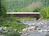
The bridge was restored in 1970 and 2004 and is still in use, with average daily traffic of 224 vehicles in 2009. Despite the restorations, as of 2009 the bridge structure's sufficiency rating on the National Bridge Inventory
was only 17.7 percent and its condition was deemed "basically intolerable requiring high priority of corrective action". It is one of three remaining covered bridges in Sullivan County, and according to Susan M. Zacher's The Covered Bridges of Pennsylvania: A Guide, its location "over the rocky Loyalsock Creek" is "one of the most attractive settings in the state."
. It is about 0.2 miles (321.9 m) south of Pennsylvania Route 87
and 2 miles (3 km) north of Worlds End State Park
on PA 154. Forksville Covered Bridge is its official name on the National Register of Historic Places (NRHP). Sullivan County is located in north central Pennsylvania, about 123 miles (198 km) northwest of Philadelphia
and 195 miles (314 km) east-northeast of Pittsburgh
.
The bridge is just upstream of the confluence
of the Little Loyalsock
and Loyalsock Creeks. This was known as the "forks of the Loyalsock" and gave Forks Township
its name when the township was incorporated in 1833, while still part of Lycoming County
. Sullivan County was formed from part of Lycoming County on March 14, 1847, and the bridge was built in 1850. The name of the bridge comes from the community of Forksville, which is on land first settled in 1794, was laid out as a village in 1854, and was incorporated as a borough from part of Forks Township on December 22, 1880.
in Philadelphia, Pennsylvania. According to Zacher, the first covered bridges of the Burr arch truss design were also built in the state. Pennsylvania is estimated to have once had at least 1,500 covered bridges and is believed to have had the most in the country between 1830 and 1875. In 2001, Pennsylvania had more surviving historic covered bridges than any other state, with 221 remaining in 40 of its 67 counties.
Covered bridges were a transition between stone and metal bridges, the latter made of cast-iron or steel. In 19th-century Pennsylvania, lumber was an abundant resource for bridge construction, but did not last long when exposed to the elements. The roof and enclosed sides of covered bridges protected the structural elements, allowing some of these bridges to survive for well over a century. A Burr arch truss consists of a load-bearing
arch
sandwiching multiple king posts, resulting in stronger and more rigid structure than one made of either element alone.
, and Sonestown
. All three are Burr arch truss covered bridges and were built in 1850. The Forksville Covered Bridge was built for Sullivan County by Sadler Rogers (or Rodgers), a native of Forksville who was only 18 at the time. He hand-carved a model of the bridge before work began and used it to supervise construction. Rogers built the Forksville and Hillsgrove bridges across Loyalsock Creek, with the latter about 5 miles (8 km) downstream of the former. Although most sources do not list the builder of the Sonestown bridge, a 1997 newspaper article on the remaining Sullivan County covered bridges reported that Rodgers had designed it too.
 The Forksville Covered Bridge was added to the NRHP on , 1980, in a Multiple Property Submission of seven Covered Bridges of Bradford, Sullivan and Lycoming Counties
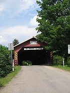
. The 2009 National Bridge Inventory (NBI) lists the covered bridge as 152 in 11 in (46.61 m) long, with a roadway 12 in 2 in (3.71 m) wide, and a maximum load of 3 short ton. According to the NRHP, the bridge's "road surface width" is 15 feet (4.6 m), which is only sufficient for a single lane of traffic. As of 2011, each portal has a small sign reading "1850 Sadler Rogers" at the top, above a sign with the posted clearance height of 8 feet (2.4 m), and a "No Trucks Allowed" sign hanging below these.
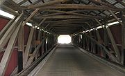
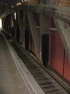
The covered bridge rests on the original stone abutment
s, which have since been reinforced with concrete. The bridge deck, which is now supported by steel beams, is made of "very narrow crosswise planks". Wheel guards on the deck separate the roadway from the pedestrian walkways on either side and protect the sides, which are covered with vertical planks almost to the eaves
. The bridge has long, narrow windows with wooden shutters: the south side has four windows, and the north side has three. An opening between the eaves and the siding runs the length of the bridge on both sides. The bridge is supported by a Burr arch truss of 16 panels, with wooden beams. The gable roof is sheet metal
and is used as the model illustration of a "classic gable roof" for a covered bridge by the U.S. Department of Transportation Federal Highway Administration
Turner-Fairbank Highway Research Center.
 In the 19th century the Forksville Covered Bridge survived major floods on March 1, 1865, and June 1, 1889, that destroyed other bridges in the West Branch Susquehanna River valley. Between about 1870 and 1890, logging in the Loyalsock Creek watershed produced lumber rafts that floated beneath the bridge. These rafts, each containing 5,000–30,000 board feet
(12–70 m3) of lumber, were carried down the Loyalsock to its mouth at Montoursville
, and some continued on the West Branch Susquehanna River beyond. The rafts ended when the eastern hemlock
were all clearcut
.
From 1908 to 1913, there was a stream gauge
on the bridge. Twice a day, the creek height was read on a chain 21.88 feet (6.67 m) long on the bridge's upstream side, and discharge
measurements were taken on the downstream side. At the time it served as a "single span, wooden, covered highway bridge". The bridge survived another major flood on November 16, 1926, when a dam broke upstream but was "badly damaged" by an ice jam
on , 1959, in a flood that left blocks of ice weighing up to 500 pounds (226.8 kg) in the streets of Forksville.
The Forksville Covered Bridge was restored in 1970 with what the NRHP nomination form describes as "all kinds of odd repairs". The restoration work was completed by T. Corbin Lewis of Hillsgrove Township
, a retired electrical contractor
, whose low bid of $48,000 was accepted over a Baltimore, Maryland, firm's $185,000 bid. The restoration was supervised by the Pennsylvania Department of Transportation
(PennDOT), which owns and maintains the bridge. The repair involved minor work on the "steel floor beams and stringers", which had been added years before. An entirely new wooden deck was installed, with wheel guards (wooden curbs
) to channel vehicle traffic to the center and to protect the pedestrian walkways on the sides. Windows were cut in the bridge's sides for the first time, and steel girders were "added to support the bridge's understructure."
 Attitudes towards covered bridges in Sullivan County changed considerably in the last half of the 20th century. Two of the five bridges remaining in 1954 were razed by 1970, when PennDOT considered tearing down the Forksville bridge too. It was renovated rather than razed because of its historic nature and appeal to tourists. The Forksville Covered Bridge was added to the NRHP in 1980, and the Pennsylvania Historical and Museum Commission
now forbids the destruction of any covered bridge on the NRHP in the state and has to approve any renovation work.
The NBI says the bridge was "reconstructed" in 2004 but does not give further details. The entire bridge has been reinforced with steel girders, including vertical beams. In 2006 the red bridge was repainted, which took about three weeks.
The bridge's condition was described as "good" in the 1980 NRHP form, Zacher's 1994 book, and the Evans' 2001 book. However, the 2009 Federal Highway Administration
National Bridge Inventory found the sufficiency rating of the bridge structure to be 17.7 percent. It found that the bridge's foundations were "determined to be stable for calculated scour
conditions" but that the railing "does not meet currently acceptable standards". Its overall condition was deemed "basically intolerable requiring high priority of corrective action"; the 2006 NBI estimated the cost to improve the bridge at $463,000.
Today the Forksville Covered Bridge is heavily used, as it is the most direct and shortest route from PA 154, at the eastern end, to Forksville and its general store
, which are at the western end. In 2000, Forksville had 147 residents. The posted speed limit is 15 miles per hour (6.7 m/s), and its average daily traffic was 224 vehicles in 2009. The bridge is used as the logo of the Farmers & Mechanics Mutual Insurance Company, which was founded in Sullivan County in 1877.
In addition to its utility, the bridge is appreciated for its history and beauty. In 1970 a long-time Forksville resident spoke of the bridge's connection to the past: "When you stand quiet on the bridge and the woods are still, you can almost hear the horses clomping over the wooden deck as they did in years gone by; you can almost see the youngsters who climbed the rafters of the bridge to 'skinny-dip' in the creek below". Zacher's 1994 The Covered Bridges of Pennsylvania: A Guide describes the bridge's location "over the rocky Loyalsock Creek" as "one of the most attractive settings in the state."
 The following table is a comparison of published measurements of length, width and load recorded by four different sources using different methods, as well as the name cited for the bridge and its builder. The NBI measures bridge length between the "backwalls of abutments" or pavement grooves and the roadway width as "the most restrictive minimum distance between curbs or rails". The NRHP form was prepared by the Pennsylvania Historical and Museum Commission
(PHMC), which surveyed county engineers, historical and covered bridge societies, and others for all the covered bridges in the commonwealth. The Evans visited every covered bridge in Pennsylvania in 2001 and measured each bridge's length (portal to portal) and width (at the portal) for their book. The data in Zacher's book was based on a 1991 survey of all covered bridges in Pennsylvania by the PHMC and PennDOT, aided by local government and private agencies. The article uses primarily the NBI and NRHP data, as they are national programs.
Burr Truss
The Burr Arch Truss — or simply Burr Truss or Burr Arch — is a combination of an arch and a multiple kingpost truss design. It was invented in 1804 by Theodore Burr, patented on April 3, 1817, and used in bridges, usually covered bridges....
covered bridge
Covered bridge
A covered bridge is a bridge with enclosed sides and a roof, often accommodating only a single lane of traffic. Most covered bridges are wooden; some newer ones are concrete or metal with glass sides...
over Loyalsock Creek
Loyalsock Creek
Loyalsock Creek is a tributary of the West Branch Susquehanna River located chiefly in Sullivan and Lycoming counties in Pennsylvania in the United States...
in the borough of Forksville
Forksville, Pennsylvania
Forksville is a borough in Sullivan County, Pennsylvania, United States. The population was 145 at the 2010 census. It is the home of the 150 year old Forksville General Store, down the road from the Sullivan County Fairgrounds, and near Worlds End State Park...
, Sullivan County
Sullivan County, Pennsylvania
Sullivan County is a county located in the U.S. state of Pennsylvania. As of 2010, the population is 6,428. Sullivan County was created on March 15, 1847, from part of Lycoming County and named for Charles Sullivan, leader of the Pennsylvania Senate...
, in the U.S. state of Pennsylvania
Pennsylvania
The Commonwealth of Pennsylvania is a U.S. state that is located in the Northeastern and Mid-Atlantic regions of the United States. The state borders Delaware and Maryland to the south, West Virginia to the southwest, Ohio to the west, New York and Ontario, Canada, to the north, and New Jersey to...
. It was built in 1850 and is 152 in 11 in (46.61 m) in length. The bridge was placed on the National Register of Historic Places in 1980. The Forksville bridge is named for the borough it is in, which in turn is named for its location at the confluence
Confluence (geography)
In geography, a confluence is the meeting of two or more bodies of water. It usually refers to the point where two streams flow together, merging into a single stream...
or "forks" of the Little Loyalsock
Little Loyalsock Creek
Little Loyalsock Creek is the major tributary of Loyalsock Creek in Lycoming and Sullivan counties, Pennsylvania, USA. The creek is long. Via Loyalsock Creek and the West Branch Susquehanna River, it is part of the Susquehanna River drainage basin, and waters from it flow ultimately into the...
and Loyalsock Creeks.
Pennsylvania had the first covered bridge in the United States and the most such bridges in both the 19th and 21st centuries. They were a transition between stone and metal bridges, with the roof and sides protecting the wooden structure from weather. The Forksville bridge is a Burr arch truss type, with a load-bearing
Structural engineering
Structural engineering is a field of engineering dealing with the analysis and design of structures that support or resist loads. Structural engineering is usually considered a specialty within civil engineering, but it can also be studied in its own right....
arch
Arch
An arch is a structure that spans a space and supports a load. Arches appeared as early as the 2nd millennium BC in Mesopotamian brick architecture and their systematic use started with the Ancient Romans who were the first to apply the technique to a wide range of structures.-Technical aspects:The...
sandwiching multiple vertical king posts, for strength and rigidity. The building of the Forksville bridge was supervised by the 18-year-old Sadler Rogers
Sadler Rogers
Sadler Rogers , , was an American builder and farmer. Sadler Rodgers built several bridges which are now considered part of the historic heritage of Pennsylvania, including the Forksville Covered Bridge.-References:...
, who used his hand-carved model of the structure. It served as the site of a stream gauge
Stream gauge
A stream gauge, stream gage or gauging station is a location used by hydrologists or environmental scientists to monitor and test terrestrial bodies of water. Hydrometric measurements of water surface elevation and/or volumetric discharge are generally taken and observations of biota may also be...
from 1908 to 1913 and is still an official Pennsylvania state highway bridge. The United States Department of Transportation
United States Department of Transportation
The United States Department of Transportation is a federal Cabinet department of the United States government concerned with transportation. It was established by an act of Congress on October 15, 1966, and began operation on April 1, 1967...
Federal Highway Administration
Federal Highway Administration
The Federal Highway Administration is a division of the United States Department of Transportation that specializes in highway transportation. The agency's major activities are grouped into two "programs," the Federal-aid Highway Program and the Federal Lands Highway Program...
uses it as the model of a covered bridge "classic gable
Gable
A gable is the generally triangular portion of a wall between the edges of a sloping roof. The shape of the gable and how it is detailed depends on the structural system being used and aesthetic concerns. Thus the type of roof enclosing the volume dictates the shape of the gable...
roof", and it serves as the logo
Logo
A logo is a graphic mark or emblem commonly used by commercial enterprises, organizations and even individuals to aid and promote instant public recognition...
of a Pennsylvania insurance company.
The bridge was restored in 1970 and 2004 and is still in use, with average daily traffic of 224 vehicles in 2009. Despite the restorations, as of 2009 the bridge structure's sufficiency rating on the National Bridge Inventory
National Bridge Inventory
The National Bridge Inventory is a database, compiled by the Federal Highway Administration, with information on all bridges and tunnels in the United States that have roads passing above or below. This is similar to the grade crossing identifier number database compiled by the Federal Railroad...
was only 17.7 percent and its condition was deemed "basically intolerable requiring high priority of corrective action". It is one of three remaining covered bridges in Sullivan County, and according to Susan M. Zacher's The Covered Bridges of Pennsylvania: A Guide, its location "over the rocky Loyalsock Creek" is "one of the most attractive settings in the state."
Overview
The covered bridge is in the borough of Forksville on Bridge Street, a spur of State Route 4012, just west of Pennsylvania Route 154Pennsylvania Route 154
Pennsylvania Route 154 is a 32-mile-long northwest-southeast state highway located in northern Pennsylvania. The southern terminus is at U.S. Route 220 in Laporte. The northern terminus of the route is at PA 414 in Canton....
. It is about 0.2 miles (321.9 m) south of Pennsylvania Route 87
Pennsylvania Route 87
Pennsylvania Route 87 is a long north–south state highway located in northern Pennsylvania. The southern terminus of the route is at exit 21 of Interstate 180 and U.S. Route 220 in Montoursville. The northern terminus is at U.S. Route 6 in Washington Township.The road is called Loyalsock...
and 2 miles (3 km) north of Worlds End State Park
Worlds End State Park
Worlds End State Park is a Pennsylvania state park in Sullivan County, Pennsylvania, in the United States. The park, nearly surrounded by Loyalsock State Forest, is in the Loyalsock Creek valley on Pennsylvania Route 154, in Forks and Shrewsbury Townships just east of the borough of Forksville....
on PA 154. Forksville Covered Bridge is its official name on the National Register of Historic Places (NRHP). Sullivan County is located in north central Pennsylvania, about 123 miles (198 km) northwest of Philadelphia
Philadelphia, Pennsylvania
Philadelphia is the largest city in the Commonwealth of Pennsylvania and the county seat of Philadelphia County, with which it is coterminous. The city is located in the Northeastern United States along the Delaware and Schuylkill rivers. It is the fifth-most-populous city in the United States,...
and 195 miles (314 km) east-northeast of Pittsburgh
Pittsburgh, Pennsylvania
Pittsburgh is the second-largest city in the US Commonwealth of Pennsylvania and the county seat of Allegheny County. Regionally, it anchors the largest urban area of Appalachia and the Ohio River Valley, and nationally, it is the 22nd-largest urban area in the United States...
.
The bridge is just upstream of the confluence
Confluence (geography)
In geography, a confluence is the meeting of two or more bodies of water. It usually refers to the point where two streams flow together, merging into a single stream...
of the Little Loyalsock
Little Loyalsock Creek
Little Loyalsock Creek is the major tributary of Loyalsock Creek in Lycoming and Sullivan counties, Pennsylvania, USA. The creek is long. Via Loyalsock Creek and the West Branch Susquehanna River, it is part of the Susquehanna River drainage basin, and waters from it flow ultimately into the...
and Loyalsock Creeks. This was known as the "forks of the Loyalsock" and gave Forks Township
Forks Township, Sullivan County, Pennsylvania
Forks Township is a township in Sullivan County, Pennsylvania, USA. The population was 407 at the 2000 census.-Geography:According to the United States Census Bureau, the township has a total area of , of which, of it is land and of it is water....
its name when the township was incorporated in 1833, while still part of Lycoming County
Lycoming County, Pennsylvania
-Appalachian Mountains and Allegheny Plateau:Lycoming County is divided between the Appalachian Mountains in the south, the dissected Allegheny Plateau in the north and east, and the valley of the West Branch Susquehanna River between these.-West Branch Susquehanna River:The West Branch of the...
. Sullivan County was formed from part of Lycoming County on March 14, 1847, and the bridge was built in 1850. The name of the bridge comes from the community of Forksville, which is on land first settled in 1794, was laid out as a village in 1854, and was incorporated as a borough from part of Forks Township on December 22, 1880.
Background
The first covered bridge in the United States was built in 1800 over the Schuylkill RiverSchuylkill River
The Schuylkill River is a river in Pennsylvania. It is a designated Pennsylvania Scenic River.The river is about long. Its watershed of about lies entirely within the state of Pennsylvania. The source of its eastern branch is in the Appalachian Mountains at Tuscarora Springs, near Tamaqua in...
in Philadelphia, Pennsylvania. According to Zacher, the first covered bridges of the Burr arch truss design were also built in the state. Pennsylvania is estimated to have once had at least 1,500 covered bridges and is believed to have had the most in the country between 1830 and 1875. In 2001, Pennsylvania had more surviving historic covered bridges than any other state, with 221 remaining in 40 of its 67 counties.
Covered bridges were a transition between stone and metal bridges, the latter made of cast-iron or steel. In 19th-century Pennsylvania, lumber was an abundant resource for bridge construction, but did not last long when exposed to the elements. The roof and enclosed sides of covered bridges protected the structural elements, allowing some of these bridges to survive for well over a century. A Burr arch truss consists of a load-bearing
Structural engineering
Structural engineering is a field of engineering dealing with the analysis and design of structures that support or resist loads. Structural engineering is usually considered a specialty within civil engineering, but it can also be studied in its own right....
arch
Arch
An arch is a structure that spans a space and supports a load. Arches appeared as early as the 2nd millennium BC in Mesopotamian brick architecture and their systematic use started with the Ancient Romans who were the first to apply the technique to a wide range of structures.-Technical aspects:The...
sandwiching multiple king posts, resulting in stronger and more rigid structure than one made of either element alone.
Construction and description
Although there were 30 covered bridges in Sullivan County in 1890, only five were left by 1954, and as of 2011 only three remain: Forksville, HillsgroveHillsgrove Covered Bridge
The Hillsgrove Covered Bridge is a Burr arch truss covered bridge over Loyalsock Creek in Hillsgrove Township, Sullivan County in the U.S. state of Pennsylvania. It was built circa 1850 and is long. In 1973, it became the first covered bridge in the county to be placed on the National Register of...
, and Sonestown
Sonestown Covered Bridge
The Sonestown Covered Bridge is a Burr arch truss covered bridge over Muncy Creek in Davidson Township, Sullivan County, in the U.S. state of Pennsylvania. Built circa 1850, the bridge is long, and was placed on the National Register of Historic Places in 1980...
. All three are Burr arch truss covered bridges and were built in 1850. The Forksville Covered Bridge was built for Sullivan County by Sadler Rogers (or Rodgers), a native of Forksville who was only 18 at the time. He hand-carved a model of the bridge before work began and used it to supervise construction. Rogers built the Forksville and Hillsgrove bridges across Loyalsock Creek, with the latter about 5 miles (8 km) downstream of the former. Although most sources do not list the builder of the Sonestown bridge, a 1997 newspaper article on the remaining Sullivan County covered bridges reported that Rodgers had designed it too.
Covered Bridges of Bradford, Sullivan and Lycoming Counties
The Covered Bridges of Bradford, Sullivan and Lycoming Counties are seven covered bridges in northcentral Pennsylvania in the United States, which were included on the National Register of Historic Places in a Thematic Resources submission on July 24, 1980. One of the bridges is in Bradford...
. The 2009 National Bridge Inventory (NBI) lists the covered bridge as 152 in 11 in (46.61 m) long, with a roadway 12 in 2 in (3.71 m) wide, and a maximum load of 3 short ton. According to the NRHP, the bridge's "road surface width" is 15 feet (4.6 m), which is only sufficient for a single lane of traffic. As of 2011, each portal has a small sign reading "1850 Sadler Rogers" at the top, above a sign with the posted clearance height of 8 feet (2.4 m), and a "No Trucks Allowed" sign hanging below these.
The covered bridge rests on the original stone abutment
Abutment
An abutment is, generally, the point where two structures or objects meet. This word comes from the verb abut, which means adjoin or having common boundary. An abutment is an engineering term that describes a structure located at the ends of a bridge, where the bridge slab adjoins the approaching...
s, which have since been reinforced with concrete. The bridge deck, which is now supported by steel beams, is made of "very narrow crosswise planks". Wheel guards on the deck separate the roadway from the pedestrian walkways on either side and protect the sides, which are covered with vertical planks almost to the eaves
Eaves
The eaves of a roof are its lower edges. They usually project beyond the walls of the building to carry rain water away.-Etymology:"Eaves" is derived from Old English and is both the singular and plural form of the word.- Function :...
. The bridge has long, narrow windows with wooden shutters: the south side has four windows, and the north side has three. An opening between the eaves and the siding runs the length of the bridge on both sides. The bridge is supported by a Burr arch truss of 16 panels, with wooden beams. The gable roof is sheet metal
Sheet metal
Sheet metal is simply metal formed into thin and flat pieces. It is one of the fundamental forms used in metalworking, and can be cut and bent into a variety of different shapes. Countless everyday objects are constructed of the material...
and is used as the model illustration of a "classic gable roof" for a covered bridge by the U.S. Department of Transportation Federal Highway Administration
Federal Highway Administration
The Federal Highway Administration is a division of the United States Department of Transportation that specializes in highway transportation. The agency's major activities are grouped into two "programs," the Federal-aid Highway Program and the Federal Lands Highway Program...
Turner-Fairbank Highway Research Center.
Restoration and use
Board foot
The board-foot is a specialized unit of measure for the volume of lumber in the United States and Canada. It is the volume of a one-foot length of a board one foot wide and one inch thick....
(12–70 m3) of lumber, were carried down the Loyalsock to its mouth at Montoursville
Montoursville, Pennsylvania
Montoursville is a borough in Lycoming County, Pennsylvania, in the United States. As of the 2000 census, the borough population was 4,777. It is part of the Williamsport, Pennsylvania Metropolitan Statistical Area. It was named for Madame Montour, a Native American leader and skilled interpreter...
, and some continued on the West Branch Susquehanna River beyond. The rafts ended when the eastern hemlock
Eastern Hemlock
Tsuga canadensis, also known as eastern or Canadian hemlock, and in the French-speaking regions of Canada as pruche du Canada, is a coniferous tree native to eastern North America. It ranges from northeastern Minnesota eastward through southern Quebec to Nova Scotia, and south in the Appalachian...
were all clearcut
Clearcutting
Clearcutting, or clearfelling, is a controversial forestry/logging practice in which most or all trees in an area are uniformly cut down. Clearcutting, along with shelterwood and seed tree harvests, is used by foresters to create certain types of forest ecosystems and to promote select species that...
.
From 1908 to 1913, there was a stream gauge
Stream gauge
A stream gauge, stream gage or gauging station is a location used by hydrologists or environmental scientists to monitor and test terrestrial bodies of water. Hydrometric measurements of water surface elevation and/or volumetric discharge are generally taken and observations of biota may also be...
on the bridge. Twice a day, the creek height was read on a chain 21.88 feet (6.67 m) long on the bridge's upstream side, and discharge
Discharge (hydrology)
In hydrology, discharge is the volume rate of water flow, including any suspended solids , dissolved chemical species and/or biologic material , which is transported through a given cross-sectional area...
measurements were taken on the downstream side. At the time it served as a "single span, wooden, covered highway bridge". The bridge survived another major flood on November 16, 1926, when a dam broke upstream but was "badly damaged" by an ice jam
Ice dam
An ice dam occurs when water builds up behind a blockage of ice. Ice dams can occur in various ways.-Caused by a glacier:Sometimes a glacier flows down a valley to a confluence where the other branch carries an unfrozen river...
on , 1959, in a flood that left blocks of ice weighing up to 500 pounds (226.8 kg) in the streets of Forksville.
The Forksville Covered Bridge was restored in 1970 with what the NRHP nomination form describes as "all kinds of odd repairs". The restoration work was completed by T. Corbin Lewis of Hillsgrove Township
Hillsgrove Township, Pennsylvania
Hillsgrove Township is a township in Sullivan County, Pennsylvania, United States. The population was 265 at the 2000 census.-Geography:According to the United States Census Bureau, the township has a total area of , of which, of it is land and 0.04% is water.Hillsgrove Township is bordered by Fox...
, a retired electrical contractor
General contractor
A general contractor is responsible for the day-to-day oversight of a construction site, management of vendors and trades, and communication of information to involved parties throughout the course of a building project.-Description:...
, whose low bid of $48,000 was accepted over a Baltimore, Maryland, firm's $185,000 bid. The restoration was supervised by the Pennsylvania Department of Transportation
Pennsylvania Department of Transportation
The Pennsylvania Department of Transportation oversees transportation issues in the Commonwealth of Pennsylvania. The administrator of PennDOT is the Pennsylvania Secretary of Transportation, currently Barry Schoch Presently, PennDOT supports over of state roads and highways, about 25,000...
(PennDOT), which owns and maintains the bridge. The repair involved minor work on the "steel floor beams and stringers", which had been added years before. An entirely new wooden deck was installed, with wheel guards (wooden curbs
Curb (road)
A curb, or kerb , is the edge where a raised pavement/sidewalk/footpath, road median, or road shoulder meets an unraised street or other roadway.-Function:...
) to channel vehicle traffic to the center and to protect the pedestrian walkways on the sides. Windows were cut in the bridge's sides for the first time, and steel girders were "added to support the bridge's understructure."
Pennsylvania Historical and Museum Commission
The Pennsylvania Historical and Museum Commission is the governmental agency of the Commonwealth of Pennsylvania responsible for the collection, conservation and interpretation of Pennsylvania's historic heritage...
now forbids the destruction of any covered bridge on the NRHP in the state and has to approve any renovation work.
The NBI says the bridge was "reconstructed" in 2004 but does not give further details. The entire bridge has been reinforced with steel girders, including vertical beams. In 2006 the red bridge was repainted, which took about three weeks.
The bridge's condition was described as "good" in the 1980 NRHP form, Zacher's 1994 book, and the Evans' 2001 book. However, the 2009 Federal Highway Administration
Federal Highway Administration
The Federal Highway Administration is a division of the United States Department of Transportation that specializes in highway transportation. The agency's major activities are grouped into two "programs," the Federal-aid Highway Program and the Federal Lands Highway Program...
National Bridge Inventory found the sufficiency rating of the bridge structure to be 17.7 percent. It found that the bridge's foundations were "determined to be stable for calculated scour
Bridge scour
Bridge scour is the removal of sediment such as sand and rocks from around bridge abutments or piers. Scour, caused by swiftly moving water, can scoop out scour holes, compromising the integrity of a structure....
conditions" but that the railing "does not meet currently acceptable standards". Its overall condition was deemed "basically intolerable requiring high priority of corrective action"; the 2006 NBI estimated the cost to improve the bridge at $463,000.
Today the Forksville Covered Bridge is heavily used, as it is the most direct and shortest route from PA 154, at the eastern end, to Forksville and its general store
General store
A general store, general merchandise store, or village shop is a rural or small town store that carries a general line of merchandise. It carries a broad selection of merchandise, sometimes in a small space, where people from the town and surrounding rural areas come to purchase all their general...
, which are at the western end. In 2000, Forksville had 147 residents. The posted speed limit is 15 miles per hour (6.7 m/s), and its average daily traffic was 224 vehicles in 2009. The bridge is used as the logo of the Farmers & Mechanics Mutual Insurance Company, which was founded in Sullivan County in 1877.
In addition to its utility, the bridge is appreciated for its history and beauty. In 1970 a long-time Forksville resident spoke of the bridge's connection to the past: "When you stand quiet on the bridge and the woods are still, you can almost hear the horses clomping over the wooden deck as they did in years gone by; you can almost see the youngsters who climbed the rafters of the bridge to 'skinny-dip' in the creek below". Zacher's 1994 The Covered Bridges of Pennsylvania: A Guide describes the bridge's location "over the rocky Loyalsock Creek" as "one of the most attractive settings in the state."
Bridge data
Pennsylvania Historical and Museum Commission
The Pennsylvania Historical and Museum Commission is the governmental agency of the Commonwealth of Pennsylvania responsible for the collection, conservation and interpretation of Pennsylvania's historic heritage...
(PHMC), which surveyed county engineers, historical and covered bridge societies, and others for all the covered bridges in the commonwealth. The Evans visited every covered bridge in Pennsylvania in 2001 and measured each bridge's length (portal to portal) and width (at the portal) for their book. The data in Zacher's book was based on a 1991 survey of all covered bridges in Pennsylvania by the PHMC and PennDOT, aided by local government and private agencies. The article uses primarily the NBI and NRHP data, as they are national programs.
| Length feet (m) |
Width feet (m) |
Load short tons (MT) |
Name used |
Builder | Source (Year) |
|---|---|---|---|---|---|
| 152 in 11 in (46.61 m) | 12 in 2 in (3.71 m) | 3 short tons (2.7 MT) | SR 4012 | NA | NBI (2009) |
| 146 feet (44.5 m) | 15 feet (4.6 m) | NA | Forksville | Sadler Rogers | NRHP (1980) |
| 163 in 3 in (49.76 m) | 18 foot | NA | Forksville | Sadler Rodgers | Evans (2001) |
| 130 feet (39.6 m) | 15 feet (4.6 m) | NA | Forksville | Sadler Rodgers | Zacher (1994) |