

Capps, Florida
Encyclopedia
Jefferson County, Florida
Jefferson County is a county located in the U.S. state of Florida. As of 2000, the population is 12,902. The U.S. Census Bureau 2005 estimate for the county is 14,490 . Its county seat is Monticello, Florida....
, Florida
Florida
Florida is a state in the southeastern United States, located on the nation's Atlantic and Gulf coasts. It is bordered to the west by the Gulf of Mexico, to the north by Alabama and Georgia and to the east by the Atlantic Ocean. With a population of 18,801,310 as measured by the 2010 census, it...
, United States
United States
The United States of America is a federal constitutional republic comprising fifty states and a federal district...
. It is located at the intersection of US 19
U.S. Route 19 in Florida
U.S. Route 19 in Florida runs along Florida's west coast from an interchange with U.S. Route 41 in Memphis, Florida, south of Tampa, and continues to the Georgia border north of Monticello, Florida....
and US 27
U.S. Route 27
U.S. Route 27 is a north–south United States highway in the southern and midwestern United States. The southern terminus is at US 1 in Miami, Florida. The northern terminus is at Interstate 69 in Fort Wayne, Indiana...
. During the 1940's and 50's, Capps was the headquarters of an agri-business known as Tungston Plantation, owned by Everett P. Larsh, an industrialist from Dayton, Ohio, and managed by L. H. Crampton. Tungston plantation comprised a total of approximately 16,000 acres, of which about 8,000 acres was planted in tung trees. Each year, the tung nut was harvested and brought to the mill at Capps, and its contents processed into tung oil for use in paints, varnishes and other products. During those years, Tungston Plantation constituted the largest tung operation in the U.S. under single ownership.
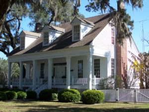
Capps is the location of the Asa May House, which is listed on the U.S. National Register of Historic Places
National Register of Historic Places
The National Register of Historic Places is the United States government's official list of districts, sites, buildings, structures, and objects deemed worthy of preservation...
.