
Flattach
Encyclopedia
Flattach is a municipality in the district of Spittal an der Drau
in the Austria
n state of Carinthia
. It consists of the Katastralgemeinden Flattach and Fragrant.
 Flattach is located in the valley of the Möll river, a tributary to the Drava
, within the Hohe Tauern
mountain range of the Central Eastern Alps
. A footpath over the Fragranter Tauern mountain pass
connected it with Rauris
in the Pinzgau region of Salzburg
.
The municipality emerged in 1895 from the market town of Obervellach
in the east. For centuries it had been a mining
area, especially for iron
and copper
. Today Fragrant is the site of a hydroelectric
power station collecting water from several reservoir
s in the northern Ankogel
mountains.
Flattach mainly depends on tourism offering the Mölltaler Gletscher ski area
located on the Wurtenkees glacier
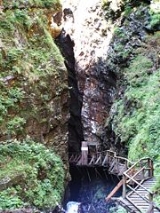
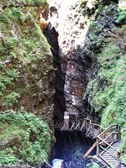
and the Raggaschlucht, a narrow gorge
within the southern Kreuzeck
mountain range with walls up to 200 m (650 ft) high and wooden walkways above the water.
in the Drava valley toward Winklern
and the Grossglockner High Alpine Road
.
Spittal an der Drau (district)
The Bezirk Spittal an der Drau is an administrative district in Carinthia, Austria.Area of the district is 2,763.99 km², population is 81,719 , and population density 30 persons per km². It is Austria's second largest district by area...
in the Austria
Austria
Austria , officially the Republic of Austria , is a landlocked country of roughly 8.4 million people in Central Europe. It is bordered by the Czech Republic and Germany to the north, Slovakia and Hungary to the east, Slovenia and Italy to the south, and Switzerland and Liechtenstein to the...
n state of Carinthia
Carinthia (state)
Carinthia is the southernmost Austrian state or Land. Situated within the Eastern Alps it is chiefly noted for its mountains and lakes.The main language is German. Its regional dialects belong to the Southern Austro-Bavarian group...
. It consists of the Katastralgemeinden Flattach and Fragrant.
Drava
Drava or Drave is a river in southern Central Europe, a tributary of the Danube. It sources in Toblach/Dobbiaco, Italy, and flows east through East Tirol and Carinthia in Austria, into Slovenia , and then southeast, passing through Croatia and forming most of the border between Croatia and...
, within the Hohe Tauern
Hohe Tauern
The Hohe Tauern or High Tauern are a mountain range on the main chain of the Central Eastern Alps, comprising the highest peaks east of the Brenner Pass. The crest forms the southern border of the Austrian state of Salzburg with Carinthia and East Tyrol, while a small part in the southwest belongs...
mountain range of the Central Eastern Alps
Central Eastern Alps
The Central Eastern Alps comprise the main chain of the Eastern Alps with its highest peaks, located between the Northern Limestone Alps and the Southern Limestone Alps, from which they differ in geological composition....
. A footpath over the Fragranter Tauern mountain pass
Mountain pass
A mountain pass is a route through a mountain range or over a ridge. If following the lowest possible route, a pass is locally the highest point on that route...
connected it with Rauris
Rauris
Rauris is a municipality in Salzburg in the area of Pinzgau in Austria. There are about 3,150 inhabitants living in Rauris.- Geography :...
in the Pinzgau region of Salzburg
Salzburg (state)
Salzburg is a state or Land of Austria with an area of 7,156 km2, located adjacent to the German border. It is also known as Salzburgerland, to distinguish it from its capital city, also named Salzburg...
.
The municipality emerged in 1895 from the market town of Obervellach
Obervellach
Obervellach is a municipality in the district of Spittal an der Drau in Carinthia in Austria. It is situated in the valley of the Möll river, on the southern slope of the Hohe Tauern mountain range...
in the east. For centuries it had been a mining
Mining
Mining is the extraction of valuable minerals or other geological materials from the earth, from an ore body, vein or seam. The term also includes the removal of soil. Materials recovered by mining include base metals, precious metals, iron, uranium, coal, diamonds, limestone, oil shale, rock...
area, especially for iron
Iron
Iron is a chemical element with the symbol Fe and atomic number 26. It is a metal in the first transition series. It is the most common element forming the planet Earth as a whole, forming much of Earth's outer and inner core. It is the fourth most common element in the Earth's crust...
and copper
Copper
Copper is a chemical element with the symbol Cu and atomic number 29. It is a ductile metal with very high thermal and electrical conductivity. Pure copper is soft and malleable; an exposed surface has a reddish-orange tarnish...
. Today Fragrant is the site of a hydroelectric
Hydroelectricity
Hydroelectricity is the term referring to electricity generated by hydropower; the production of electrical power through the use of the gravitational force of falling or flowing water. It is the most widely used form of renewable energy...
power station collecting water from several reservoir
Reservoir
A reservoir , artificial lake or dam is used to store water.Reservoirs may be created in river valleys by the construction of a dam or may be built by excavation in the ground or by conventional construction techniques such as brickwork or cast concrete.The term reservoir may also be used to...
s in the northern Ankogel
Hohe Tauern
The Hohe Tauern or High Tauern are a mountain range on the main chain of the Central Eastern Alps, comprising the highest peaks east of the Brenner Pass. The crest forms the southern border of the Austrian state of Salzburg with Carinthia and East Tyrol, while a small part in the southwest belongs...
mountains.
Flattach mainly depends on tourism offering the Mölltaler Gletscher ski area
Alpine skiing
Alpine skiing is the sport of sliding down snow-covered hills on skis with fixed-heel bindings. Alpine skiing can be contrasted with skiing using free-heel bindings: Ski mountaineering and nordic skiing – such as cross-country; ski jumping; and Telemark. In competitive alpine skiing races four...
located on the Wurtenkees glacier
Glacier
A glacier is a large persistent body of ice that forms where the accumulation of snow exceeds its ablation over many years, often centuries. At least 0.1 km² in area and 50 m thick, but often much larger, a glacier slowly deforms and flows due to stresses induced by its weight...
and the Raggaschlucht, a narrow gorge
Canyon
A canyon or gorge is a deep ravine between cliffs often carved from the landscape by a river. Rivers have a natural tendency to reach a baseline elevation, which is the same elevation as the body of water it will eventually drain into. This forms a canyon. Most canyons were formed by a process of...
within the southern Kreuzeck
Kreuzeck Group
The Kreuzeck Group is a mountain range in Carinthia, Austria, which forms part of the Central Eastern Alps. It may be considered a part of the Hohe Tauern....
mountain range with walls up to 200 m (650 ft) high and wooden walkways above the water.
Transportation
Flattach can be reached via the B106 Mölltal Straße highway running from LurnfeldLurnfeld
Lurnfeld is a market town in the district of Spittal an der Drau in the Austrian state of Carinthia. The municipality consists of the two Katastralgemeinden Möllbrücke and Pusarnitz....
in the Drava valley toward Winklern
Winklern
Winklern is a town in the district of Spittal an der Drau in Carinthia in Austria....
and the Grossglockner High Alpine Road
Grossglockner High Alpine Road
The Grossglockner High Alpine Road is a panoramic road in Austria, in the state of Salzburg. It connects the state of Salzburg with the state of Carinthia...
.