

Fil de Cassons
Encyclopedia
Fil de Cassons is a mountain
in the Glarus
Alps
, located near Flims
in the canton of Graubünden
, Switzerland
.
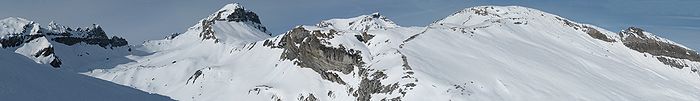
The southern face is referred to as "Flimserstein" , dominating the appearance of the town of Flims. In its east lies Bargis from where a valley leads to its north face, while to its western face the sliding surface tears off of the biggest visible landslide
in the world, Flims Rockslide
. Piz Dolf is lying to the north across the Bargis valley, and to its west Piz Segnas, both showing the tectonic line of the Glarus thrust
in its upper part, a now UNESCO world heritage.
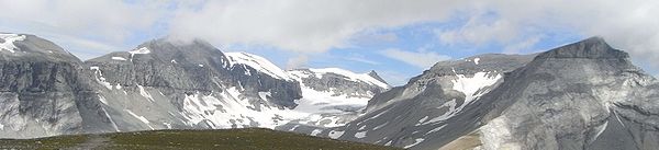
The easiest access to Fil de Cassons is an aerial cableway from Flims
to this ridge, that actually allows also walks and an alpine experience from the cablecar for people that would not dare to walk a steep mountain path. Walking on top you will easily identify the tectonic line under your feet, as rocks turn from greenish to bright light grey on top of the wide ridge.
For hikers aiming for more than a walk, several routes reach the high plateau and the very wide ridge, among them a historic Via Ferrata
called Pinut. One hiking route uses the ascent via Val Bargis and Scala Mola, the path that the cows are being sent up to graze in summer. If you stay at the base of the valley of Bargis, you will hike on a path leading more or less around Fil de Cassons from east to northwest before reaching its top..
Being a ridge, there is very often hardly snow, allowing walks even in winter along at least one mile on Fil de Cassons.
Mountain
Image:Himalaya_annotated.jpg|thumb|right|The Himalayan mountain range with Mount Everestrect 58 14 160 49 Chomo Lonzorect 200 28 335 52 Makalurect 378 24 566 45 Mount Everestrect 188 581 920 656 Tibetan Plateaurect 250 406 340 427 Rong River...
in the Glarus
Glarus Alps
The Glarus Alps are a mountain range in central Switzerland. They extend from the Oberalp Pass to the Klausen Pass, and are bordered by the Urner Alps to the west, the Lepontine Alps to the south and the Appenzell Alps to the northeast...
Alps
Swiss Alps
The Swiss Alps are the portion of the Alps mountain range that lies within Switzerland. Because of their central position within the entire Alpine range, they are also known as the Central Alps....
, located near Flims
Flims
Flims is a municipality in the district of Imboden in the Swiss canton of Graubünden. The town of Flims is dominated by the Flimserstein which you can see from almost anywhere in the area....
in the canton of Graubünden
Graubünden
Graubünden or Grisons is the largest and easternmost canton of Switzerland. The canton shares borders with the cantons of Ticino, Uri, Glarus and St. Gallen and international borders with Italy, Austria and Liechtenstein...
, Switzerland
Switzerland
Switzerland name of one of the Swiss cantons. ; ; ; or ), in its full name the Swiss Confederation , is a federal republic consisting of 26 cantons, with Bern as the seat of the federal authorities. The country is situated in Western Europe,Or Central Europe depending on the definition....
.
The southern face is referred to as "Flimserstein" , dominating the appearance of the town of Flims. In its east lies Bargis from where a valley leads to its north face, while to its western face the sliding surface tears off of the biggest visible landslide
Landslide
A landslide or landslip is a geological phenomenon which includes a wide range of ground movement, such as rockfalls, deep failure of slopes and shallow debris flows, which can occur in offshore, coastal and onshore environments...
in the world, Flims Rockslide
Flims Rockslide
Flims Rockslide occurred some 10000 years ago. It is known as the biggest Landslide incident in the Alps and the biggest worldwide whose effects are still visible, moving some of rock, about 300 times that of the historic Swiss Goldau landslide. The town of Flims can be found at the line where...
. Piz Dolf is lying to the north across the Bargis valley, and to its west Piz Segnas, both showing the tectonic line of the Glarus thrust
Glarus thrust
The Glarus thrust is a major thrust fault in the Alps of eastern Switzerland. Along the thrust the Helvetic nappes were thrusted more than 100 km to the north over the external Aarmassif and Infrahelvetic complex...
in its upper part, a now UNESCO world heritage.
The easiest access to Fil de Cassons is an aerial cableway from Flims
Flims
Flims is a municipality in the district of Imboden in the Swiss canton of Graubünden. The town of Flims is dominated by the Flimserstein which you can see from almost anywhere in the area....
to this ridge, that actually allows also walks and an alpine experience from the cablecar for people that would not dare to walk a steep mountain path. Walking on top you will easily identify the tectonic line under your feet, as rocks turn from greenish to bright light grey on top of the wide ridge.
For hikers aiming for more than a walk, several routes reach the high plateau and the very wide ridge, among them a historic Via Ferrata
Via ferrata
A via ferrata or klettersteig is a mountain route which is equipped with fixed cables, stemples, ladders, and bridges. The use of these allows otherwise isolated routes to be joined to create longer routes which are accessible to people with a wide range of climbing abilities...
called Pinut. One hiking route uses the ascent via Val Bargis and Scala Mola, the path that the cows are being sent up to graze in summer. If you stay at the base of the valley of Bargis, you will hike on a path leading more or less around Fil de Cassons from east to northwest before reaching its top..
Being a ridge, there is very often hardly snow, allowing walks even in winter along at least one mile on Fil de Cassons.
External links
- Cassons – experiencing Nature myswitzerland.com