
Fan Hir
Encyclopedia
Fan Hir is a peak at the eastern end of the Black Mountain
in the Brecon Beacons National Park in south Wales
. It is a subsidiary summit of Fan Brycheiniog
. It falls within the county of Powys
and is also a part of the traditional area of Fforest Fawr
. Its Welsh
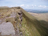
name means 'long peak', a fitting description, particularly if seen from the east when its steep eastern face is seen to advantage. Its flat summit is just over 760m above sea level. Fan Hir is separated from its higher neighbour to the north-west, Fan Brycheiniog
(802m) by a col known as Bwlch Giedd.
The hill is drained to east and west by streams which make their way into the River Tawe
.
laid down during the Devonian period. In accord with a regional trend, the beds dips southwards into the South Wales Coalfield
basin.
A notable feature of the hill is the prominent ridge of Fan Fechan (the 'little peak') which parallels the main ridge below it to the east. It is largely composed of broken Old Red Sandstone and has been interpreted as either a glacial moraine or as a pro-talus rampart. The peak is within the Fforest Fawr Geopark
designated in 2005 in recognition of the area's geological heritage.
Black Mountain (range)
The Black Mountain is a mountain range in Mid and West Wales, straddling the county boundary between Carmarthenshire and Powys and forming the westernmost range of the Brecon Beacons National Park. Its highest point is Fan Brycheiniog at 802 metres or 2,631 ft. The Black Mountain also forms a part...
in the Brecon Beacons National Park in south Wales
Wales
Wales is a country that is part of the United Kingdom and the island of Great Britain, bordered by England to its east and the Atlantic Ocean and Irish Sea to its west. It has a population of three million, and a total area of 20,779 km²...
. It is a subsidiary summit of Fan Brycheiniog
Fan Brycheiniog
Fan Brycheiniog is the highest peak in the Black Mountain region of the Brecon Beacons National Park in South Wales. It is just inside the county of Powys, and also within the Fforest Fawr Geopark designated in 2005 in recognition of the area's geological heritage.The Beacons Way, a waymarked long...
. It falls within the county of Powys
Powys
Powys is a local-government county and preserved county in Wales.-Geography:Powys covers the historic counties of Montgomeryshire and Radnorshire, most of Brecknockshire , and a small part of Denbighshire — an area of 5,179 km², making it the largest county in Wales by land area.It is...
and is also a part of the traditional area of Fforest Fawr
Fforest Fawr
Fforest Fawr is the name given to an extensive upland area in the county of Powys, Wales. Formerly known as the 'Great Forest of Brecknock' in English, it was a royal hunting area for several centuries but is now used primarily for sheep grazing, forestry, water catchment and recreation...
. Its Welsh
Welsh language
Welsh is a member of the Brythonic branch of the Celtic languages spoken natively in Wales, by some along the Welsh border in England, and in Y Wladfa...
name means 'long peak', a fitting description, particularly if seen from the east when its steep eastern face is seen to advantage. Its flat summit is just over 760m above sea level. Fan Hir is separated from its higher neighbour to the north-west, Fan Brycheiniog
Fan Brycheiniog
Fan Brycheiniog is the highest peak in the Black Mountain region of the Brecon Beacons National Park in South Wales. It is just inside the county of Powys, and also within the Fforest Fawr Geopark designated in 2005 in recognition of the area's geological heritage.The Beacons Way, a waymarked long...
(802m) by a col known as Bwlch Giedd.
The hill is drained to east and west by streams which make their way into the River Tawe
River Tawe
The River Tawe is a river in South Wales. It flows in a principally south-westerly direction for some from its source below Moel Feity in the Old Red Sandstone hills of the western Brecon Beacons to the Bristol Channel at Swansea. Its main tributaries are the right bank Upper and Lower Clydach...
.
Geology
The peak is formed from sandstones of the Brownstones Formation and the overlying Plateau Beds Formation of the Old Red SandstoneOld Red Sandstone
The Old Red Sandstone is a British rock formation of considerable importance to early paleontology. For convenience the short version of the term, 'ORS' is often used in literature on the subject.-Sedimentology:...
laid down during the Devonian period. In accord with a regional trend, the beds dips southwards into the South Wales Coalfield
South Wales Coalfield
The South Wales Coalfield is a large region of south Wales that is rich with coal deposits, especially the South Wales Valleys.-The coalfield area:...
basin.
A notable feature of the hill is the prominent ridge of Fan Fechan (the 'little peak') which parallels the main ridge below it to the east. It is largely composed of broken Old Red Sandstone and has been interpreted as either a glacial moraine or as a pro-talus rampart. The peak is within the Fforest Fawr Geopark
Fforest Fawr Geopark
Fforest Fawr Geopark was the first Geopark to be designated in Wales having gained membership of both the European Geoparks Network and the UNESCO-assisted Global Network of National Geoparks in October 2005. The Geopark aims to promote and support sustainable tourism and other opportunities to...
designated in 2005 in recognition of the area's geological heritage.