

Black Mountain (range)
Encyclopedia
Mountain range
A mountain range is a single, large mass consisting of a succession of mountains or narrowly spaced mountain ridges, with or without peaks, closely related in position, direction, formation, and age; a component part of a mountain system or of a mountain chain...
in Mid and West Wales, straddling the county boundary between Carmarthenshire
Carmarthenshire
Carmarthenshire is a unitary authority in the south west of Wales and one of thirteen historic counties. It is the 3rd largest in Wales. Its three largest towns are Llanelli, Carmarthen and Ammanford...
and Powys
Powys
Powys is a local-government county and preserved county in Wales.-Geography:Powys covers the historic counties of Montgomeryshire and Radnorshire, most of Brecknockshire , and a small part of Denbighshire — an area of 5,179 km², making it the largest county in Wales by land area.It is...
and forming the westernmost range of the Brecon Beacons National Park. Its highest point is Fan Brycheiniog
Fan Brycheiniog
Fan Brycheiniog is the highest peak in the Black Mountain region of the Brecon Beacons National Park in South Wales. It is just inside the county of Powys, and also within the Fforest Fawr Geopark designated in 2005 in recognition of the area's geological heritage.The Beacons Way, a waymarked long...
at 802 metres or 2,631 ft. The Black Mountain also forms a part of the recently-created Fforest Fawr
Fforest Fawr
Fforest Fawr is the name given to an extensive upland area in the county of Powys, Wales. Formerly known as the 'Great Forest of Brecknock' in English, it was a royal hunting area for several centuries but is now used primarily for sheep grazing, forestry, water catchment and recreation...
Geopark
Geopark
A Geopark is defined by the United Nations Educational, Scientific and Cultural Organization in its UNESCO Geoparks International Network of Geoparks programme as follows:...
. http://www.breconbeacons.org/geopark
The Black Mountain should not be confused with the Black Mountains
Black Mountains, Wales
The Black Mountains are a group of hills spread across parts of Powys and Monmouthshire in southeast Wales, and extending across the national border into Herefordshire, England. They are the easternmost of the four ranges of hills that comprise the Brecon Beacons National Park, and are frequently...
in the east of the National Park, nor with a 703 metre (2,306 ft) summit in the Black Mountains that is confusingly also called Black Mountain
Black Mountain (hill)
Twyn Llech also known as Black Mountain is a mountain in the Black Mountains . It is the only Marilyn to fall exactly on the Welsh-English border, straddling Powys and Herefordshire...
.
Geology
The range stretches approximately from Ammanford in the south-west to SennybridgeSennybridge
Sennybridge is a village in Powys, Mid Wales, situated some from Cardiff and from Swansea. It lies west of Brecon on the A40 trunk road to Llandovery, at the point where the River Senni flows into the Usk...
in the north-east. The larger part of these hills is formed from Old Red Sandstone
Old Red Sandstone
The Old Red Sandstone is a British rock formation of considerable importance to early paleontology. For convenience the short version of the term, 'ORS' is often used in literature on the subject.-Sedimentology:...
though bands of Carboniferous Limestone
Carboniferous limestone
Carboniferous Limestone is a term used to describe a variety of different types of limestone occurring widely across Great Britain and Ireland which were deposited during the Dinantian epoch of the Carboniferous period. They were formed between 363 and 325 million years ago...
and of Twrch Sandstone (or Millstone Grit
Millstone Grit
Millstone Grit is the name given to any of a number of coarse-grained sandstones of Carboniferous age which occur in the Northern England. The name derives from its use in earlier times as a source of millstones for use principally in watermills...
) are important landscape-forming rocks in the south and west of the range owing to their greater reistance to erosion
Erosion
Erosion is when materials are removed from the surface and changed into something else. It only works by hydraulic actions and transport of solids in the natural environment, and leads to the deposition of these materials elsewhere...
. The area was glaciated during the ice ages and a number of fresh moraine
Moraine
A moraine is any glacially formed accumulation of unconsolidated glacial debris which can occur in currently glaciated and formerly glaciated regions, such as those areas acted upon by a past glacial maximum. This debris may have been plucked off a valley floor as a glacier advanced or it may have...
s are to be found beneath the spectacular north and east facing sandstone scarps in the north-east of the range. The lakes below the escarpment
Escarpment
An escarpment is a steep slope or long cliff that occurs from erosion or faulting and separates two relatively level areas of differing elevations.-Description and variants:...
are also remnants of glacial action.
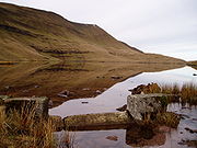
Drainage
.jpg)
River Usk
The River Usk rises on the northern slopes of the Black Mountain of mid-Wales, in the easternmost part of the Brecon Beacons National Park. Initially it flows north into Usk Reservoir, then east by Sennybridge to Brecon before turning southeast to flow by Talybont-on-Usk, Crickhowell and...
and Tawe
River Tawe
The River Tawe is a river in South Wales. It flows in a principally south-westerly direction for some from its source below Moel Feity in the Old Red Sandstone hills of the western Brecon Beacons to the Bristol Channel at Swansea. Its main tributaries are the right bank Upper and Lower Clydach...
have their sources on the eastern flanks of the range whilst the smaller Loughor
River Loughor
The River Loughor in Carmarthenshire, Wales has its source at an underground lake at the Black Mountain. It flows past settlements like Ammanford and Hendy in Carmarthenshire and Pontarddulais in Swansea. The river divides Carmarthenshire from Swansea for much of its course and it separates Hendy...
arises at the western end of the range. Significant right bank tributaries of the Tawe such as the River Giedd
River Giedd
The River Giedd is a river in Powys, Wales and which lies almost wholly within the Brecon Beacons National Park.This river is perhaps unique in the British Isles in that there are in fact two separate rivers sharing the same name and occupying the same valley but which are not hydrologically...
and the Afon Twrch
Afon Twrch
The Afon Twrch is a river which rises in the Black Mountain in south Wales. It forms the boundary between the counties of Powys and Carmarthenshire and, downstream of Ystradowen, between Powys and Neath Port Talbot county borough.The headwaters arise on the southern slopes of Bannau Sir Gaer and...
and River Amman
River Amman
The River Amman is a river of south Wales, which joins the River Loughor at Pantyffynnon. The river gives its name to the town of Ammanford and the villages of Pontamman, Glanaman, Brynamman and Rhosaman. Garnant and Betws also lie in the Amman Valley....
, a tributary of the Loughor, are the principal southerly-directed watercourses. Two left-bank tributaries of the River Towy, the River Cennen and the Afon Sawdde drain the northwestern slopes of the Black Mountain.
Llyn y Fan Fach
Llyn y Fan FachLlyn y Fan Fach
Llyn y Fan Fach is a dammed lake in the eastern border of the Black Mountain in Carmarthenshire, south Wales. Near to it is found Llyn y Fan Fawr.-Legend of Llyn y Fan Fach:...
(Welsh
Welsh language
Welsh is a member of the Brythonic branch of the Celtic languages spoken natively in Wales, by some along the Welsh border in England, and in Y Wladfa...
: 'lake of the small peak') is the smaller and more westerly of two natural lakes within the Black Mountain. It is enclosed within a rock hollow formed as a result of glacial action during the ice ages. It is drained by the Afon Sawdde which cuts through a glacial moraine which in part forms a natural dam. A small artficial dam was constructed in the 1930s to divert some of its waters to boost Llanelli
Llanelli
Llanelli , the largest town in both the county of Carmarthenshire and the preserved county of Dyfed , Wales, sits on the Loughor estuary on the West Wales coast, approximately west-north-west of Swansea and south-east of the county town, Carmarthen. The town is famous for its proud rugby...
's water supply. Llyn y Fan Fach is associated with the Lady of the Lake
Lady of the Lake
The Lady of the Lake is the name of several related characters who play parts in the Arthurian legend. These characters' roles include giving King Arthur his sword Excalibur, enchanting Merlin, and raising Lancelot after the death of his father...
legend.
Llyn y Fan Fawr
The lake Llyn y Fan FawrLlyn y Fan Fawr
Llyn y Fan Fawr is a natural lake in the county of Powys, Wales. It lies at the foot of Fan Brycheiniog, the highest peak of the Black Mountain range within the Brecon Beacons National Park....
which lies below the eastern end of the mountain is of similar origin to its westerly neighbour. It is drained by a stream known as Nant y Llyn (Welsh
Welsh language
Welsh is a member of the Brythonic branch of the Celtic languages spoken natively in Wales, by some along the Welsh border in England, and in Y Wladfa...
: 'stream of the lake'), whose waters flow into the River Tawe
River Tawe
The River Tawe is a river in South Wales. It flows in a principally south-westerly direction for some from its source below Moel Feity in the Old Red Sandstone hills of the western Brecon Beacons to the Bristol Channel at Swansea. Its main tributaries are the right bank Upper and Lower Clydach...
. The surface of Llyn y Fan Fawr lies at about 605 m above sea level.
The lake can be reached on foot by a 2 km or one mile walk across the moor from the minor Trecastle
Trecastle
Trecastle is a village in Powys, Wales, on the edge of the Brecon Beacons National Park.Trecastle is named after an early 12th century motte-and-bailey fortification , built by Bernard de Neufmarche and designed to protect Brecon from attack from the west...
to Glyntawe road.
Access
Parts of the massif are over 5 km or over 3 miles from the nearest public road making them some of the most remote areas of the country. Virtually the entire massif consists of land mapped as open countryOpen Country
Open Country is a designation used for some UK access land.It was first defined under the 1949 National Parks Act , and was land over which an appropriate access agreement had been made...
and hence legally accessible to the public on foot under the provisions of the Countryside and Rights of Way Act 2000
Countryside and Rights of Way Act 2000
The Countryside and Rights of Way Act 2000 is a UK Act of Parliament which came into force on 30 November 2000.As of September 2007, not all sections of the Countryside and Rights of Way Act have yet come into force...
.
In addition the range is crossed from north to south by a number of long bridleways which may be used by cyclists and horseriders though long sections of them are very rough and indistinct. The Beacons Way traverses the range from east to west.
Cultural Associations
The Black Mountain is generally considered to be one of the wildest regions of Wales and is associated with numerous myths such as the Lady of the Lake and Twrch TrwythTwrch Trwyth
Twrch Trwyth is an enchanted wild boar in the Arthurian legend. The hunt for Twrch Trwyth by King Arthur was the subject of a popular stock narrative in medieval Welsh literature...
. More recent events are commemorated in prose and verse eg 'From the Mist to Heaven' written after a tragedy played out on these moors in May 1904. Cribarth
Cribarth
Cribarth is a hill in the Brecon Beacons National Park in the county of Powys, south Wales. The summit of the hill is at 423m and lies at the southwest end of a mile long ridge. It is marked by a trig point...
on its southeastern margin is known locally as the Sleeping Giant, after the appearance of its profile from Cwm Tawe
River Tawe
The River Tawe is a river in South Wales. It flows in a principally south-westerly direction for some from its source below Moel Feity in the Old Red Sandstone hills of the western Brecon Beacons to the Bristol Channel at Swansea. Its main tributaries are the right bank Upper and Lower Clydach...
to the south.