

Extreme points of North America
Encyclopedia
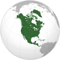
North America
North America is a continent wholly within the Northern Hemisphere and almost wholly within the Western Hemisphere. It is also considered a northern subcontinent of the Americas...
: the points that are highest and lowest, and farther north, south, east or west than any other location on the continent
Continent
A continent is one of several very large landmasses on Earth. They are generally identified by convention rather than any strict criteria, with seven regions commonly regarded as continents—they are : Asia, Africa, North America, South America, Antarctica, Europe, and Australia.Plate tectonics is...
. Some of these points are debatable, given the varying definitions of North America.
Including islands
- Northernmost Point — Kaffeklubben IslandKaffeklubben IslandKaffeklubben Island or The Coffee Club Island is a small island lying off the northern tip of Greenland. It is the northernmost point of land on Earth....
, GreenlandGreenlandGreenland is an autonomous country within the Kingdom of Denmark, located between the Arctic and Atlantic Oceans, east of the Canadian Arctic Archipelago. Though physiographically a part of the continent of North America, Greenland has been politically and culturally associated with Europe for...
(83°40'N). Although politically part of the Kingdom of DenmarkKingdom of DenmarkThe Kingdom of Denmark or the Danish Realm , is a constitutional monarchy and sovereign state consisting of Denmark proper in northern Europe and two autonomous constituent countries, the Faroe Islands in the North Atlantic and Greenland in North America. Denmark is the hegemonial part, where the...
, Greenland is geologically part of the North American plateNorth American PlateThe North American Plate is a tectonic plate covering most of North America, Greenland, Cuba, Bahamas, and parts of Siberia, Japan and Iceland. It extends eastward to the Mid-Atlantic Ridge and westward to the Chersky Range in eastern Siberia. The plate includes both continental and oceanic crust...
. If Greenland is excluded, North America's northernmost point is Cape ColumbiaCape ColumbiaCape Columbia is the northernmost point of land of Canada, located on Ellesmere Island in the Qikiqtaaluk Region of Nunavut. It marks the westernmost coastal point of Lincoln Sea in the Arctic Ocean...
, Ellesmere IslandEllesmere IslandEllesmere Island is part of the Qikiqtaaluk Region of the Canadian territory of Nunavut. Lying within the Canadian Arctic Archipelago, it is considered part of the Queen Elizabeth Islands, with Cape Columbia being the most northerly point of land in Canada...
, NunavutNunavutNunavut is the largest and newest federal territory of Canada; it was separated officially from the Northwest Territories on April 1, 1999, via the Nunavut Act and the Nunavut Land Claims Agreement Act, though the actual boundaries had been established in 1993...
, CanadaCanadaCanada is a North American country consisting of ten provinces and three territories. Located in the northern part of the continent, it extends from the Atlantic Ocean in the east to the Pacific Ocean in the west, and northward into the Arctic Ocean...
(83°08' N, 74°13'W). - Southernmost Point — Cocos IslandCocos IslandCocos Island is an uninhabited island located off the shore of Costa Rica . It constitutes the 11th district of Puntarenas Canton of the province of Puntarenas. It is one of the National Parks of Costa Rica...
, Costa RicaCosta RicaCosta Rica , officially the Republic of Costa Rica is a multilingual, multiethnic and multicultural country in Central America, bordered by Nicaragua to the north, Panama to the southeast, the Pacific Ocean to the west and the Caribbean Sea to the east....
(5°30'N) - Westernmost Point — The westernmost point depends on the definition of 'west'. If following the International Date LineInternational Date LineThe International Date Line is a generally north-south imaginary line on the surface of the Earth, passing through the middle of the Pacific Ocean, that designates the place where each calendar day begins...
, it would be Attu IslandAttu IslandAttu is the westernmost and largest island in the Near Islands group of the Aleutian Islands of Alaska, making it the westernmost point of land relative to Alaska and the United States. It was the site of the only World War II land battle fought on the incorporated territory of the United States ,...
, AlaskaAlaskaAlaska is the largest state in the United States by area. It is situated in the northwest extremity of the North American continent, with Canada to the east, the Arctic Ocean to the north, and the Pacific Ocean to the west and south, with Russia further west across the Bering Strait...
, United StatesUnited StatesThe United States of America is a federal constitutional republic comprising fifty states and a federal district...
(173°11'E). However, if the border between east and west is defined by the 180th meridian180th meridianThe 180th meridian or antimeridian is the meridian which is 180° east or west of the Prime Meridian passing through the Royal Observatory, Greenwich. It is common to both east longitude and west longitude. It is used as the basis for the International Date Line because it for the most part passes...
, the westernmost point is Amatignak IslandAmatignak IslandAmatignak Island is a member of the Delarof Islands , in Alaska's Aleutian archipelago. The south-most point of Alaska is on this island, as well as the highest western longitude of the United States and North America....
(179°06'31" W), as Attu would thus belong in the eastern hemisphereEastern HemisphereThe Eastern Hemisphere, also Eastern hemisphere or eastern hemisphere, is a geographical term for the half of the Earth that is east of the Prime Meridian and west of 180° longitude. It is also used to refer to Europe, Asia, Africa, and Australasia, vis-à-vis the Western Hemisphere, which includes...
. - Easternmost Point — NordostrundingenNordostrundingenNordostrundingen , is a headland located at the northeastern end of the island of Greenland. At 11°19'W it is the most easterly point of land in both the Americas...
, GreenlandGreenlandGreenland is an autonomous country within the Kingdom of Denmark, located between the Arctic and Atlantic Oceans, east of the Canadian Arctic Archipelago. Though physiographically a part of the continent of North America, Greenland has been politically and culturally associated with Europe for...
(12°08'W). If Greenland is excluded then the easternmost point is Cape SpearCape SpearCape Spear, located on the Avalon Peninsula near St. John's, Newfoundland, is the easternmost point in North America , excluding Greenland and the portions of Alaska west of the 180th parallel of longitude . Cape Spear is close to Blackhead, an amalgamated area of the City of St. John's, about...
, NewfoundlandNewfoundland and LabradorNewfoundland and Labrador is the easternmost province of Canada. Situated in the country's Atlantic region, it incorporates the island of Newfoundland and mainland Labrador with a combined area of . As of April 2011, the province's estimated population is 508,400...
, CanadaCanadaCanada is a North American country consisting of ten provinces and three territories. Located in the northern part of the continent, it extends from the Atlantic Ocean in the east to the Pacific Ocean in the west, and northward into the Arctic Ocean...
(52C37'W). 47°31.48′N 52°37.12′W. If one uses the official definition of longitude it is Semisopochnoi IslandSemisopochnoi IslandSemisopochnoi Island is part of the Rat Islands group in the western Aleutian Islands of Alaska. The island is uninhabited and provides an important nesting area for maritime birds. The island is of volcanic origin, containing several volcanoes including Mount Cerberus...
, Alaska, since the state technically stretches into the eastern hemisphere (Semisopochnoi is closest to 180th meridian "on the lefthand side").
Mainland
- Northernmost Point — Murchison PromontoryMurchison PromontoryMurchison Promontory is a peninsula in northern Canada that is the northernmost point on mainland Canada and on the mainland of North America; it is also one of the Extreme points of Earth....
on Boothia PeninsulaBoothia PeninsulaBoothia Peninsula is a large peninsula in Nunavut's northern Canadian Arctic, south of Somerset Island. The northern part, Murchison Promontory, is the northernmost point of mainland Canada, and thus North America....
, NunavutNunavutNunavut is the largest and newest federal territory of Canada; it was separated officially from the Northwest Territories on April 1, 1999, via the Nunavut Act and the Nunavut Land Claims Agreement Act, though the actual boundaries had been established in 1993...
, CanadaCanadaCanada is a North American country consisting of ten provinces and three territories. Located in the northern part of the continent, it extends from the Atlantic Ocean in the east to the Pacific Ocean in the west, and northward into the Arctic Ocean...
(71°58'N) - Southernmost Point — Punta MariatoPunta MariatoPunta Mariato or Mariato Point is a cape in western Panama and is the southernmost point on the mainland of North America and is one of the Extreme points of Earth.-Geography:...
, PanamaPanamaPanama , officially the Republic of Panama , is the southernmost country of Central America. Situated on the isthmus connecting North and South America, it is bordered by Costa Rica to the northwest, Colombia to the southeast, the Caribbean Sea to the north and the Pacific Ocean to the south. The...
(7°10'28.75"N 80°53'12.18"W the southern curve, not the southern border) - Westernmost Point — Cape Prince of WalesCape Prince of WalesCape Prince of Wales is the westernmost point on the mainland of the Americas.Located on the Seward Peninsula of the U.S. state of Alaska near the city of Wales, Cape Prince of Wales is the terminus of the Continental Divide, marking the division between the Pacific and Arctic coasts, as well as...
, AlaskaAlaskaAlaska is the largest state in the United States by area. It is situated in the northwest extremity of the North American continent, with Canada to the east, the Arctic Ocean to the north, and the Pacific Ocean to the west and south, with Russia further west across the Bering Strait...
, United StatesUnited StatesThe United States of America is a federal constitutional republic comprising fifty states and a federal district...
(168°05'W) - Easternmost Point — Cape St Charles, Newfoundland and LabradorNewfoundland and LabradorNewfoundland and Labrador is the easternmost province of Canada. Situated in the country's Atlantic region, it incorporates the island of Newfoundland and mainland Labrador with a combined area of . As of April 2011, the province's estimated population is 508,400...
, CanadaCanadaCanada is a North American country consisting of ten provinces and three territories. Located in the northern part of the continent, it extends from the Atlantic Ocean in the east to the Pacific Ocean in the west, and northward into the Arctic Ocean...
(55°38'W) 52°13.07′N 55°37.25′W
Altitude extremes
- Highest Point — Mount McKinleyMount McKinleyMount McKinley or Denali in Alaska, United States is the highest mountain peak in North America and the United States, with a summit elevation of above sea level. It is the centerpiece of Denali National Park and Preserve.- Geology and features :Mount McKinley is a granitic pluton...
(Denali), AlaskaAlaskaAlaska is the largest state in the United States by area. It is situated in the northwest extremity of the North American continent, with Canada to the east, the Arctic Ocean to the north, and the Pacific Ocean to the west and south, with Russia further west across the Bering Strait...
, United StatesUnited StatesThe United States of America is a federal constitutional republic comprising fifty states and a federal district...
(20,320 feet / 6,194 meters above sea level) - Lowest Point — Death ValleyDeath ValleyDeath Valley is a desert valley located in Eastern California. Situated within the Mojave Desert, it features the lowest, driest, and hottest locations in North America. Badwater, a basin located in Death Valley, is the specific location of the lowest elevation in North America at 282 feet below...
, CaliforniaCaliforniaCalifornia is a state located on the West Coast of the United States. It is by far the most populous U.S. state, and the third-largest by land area...
, United StatesUnited StatesThe United States of America is a federal constitutional republic comprising fifty states and a federal district...
(282 feet / 86 meters below sea level)
Other
The geographic center lies near Rugby, North Dakota, at 48.17°N 100.17°W.The continental pole of inaccessibility is in southwest South Dakota
South Dakota
South Dakota is a state located in the Midwestern region of the United States. It is named after the Lakota and Dakota Sioux American Indian tribes. Once a part of Dakota Territory, South Dakota became a state on November 2, 1889. The state has an area of and an estimated population of just over...
between Kyle
Kyle, South Dakota
Kyle is a census-designated place in Shannon County, South Dakota, United States. The population was 846 at the 2010 census...
and Allen
Allen, South Dakota
Allen is a census-designated place in Bennett County, South Dakota. As of the 2010 census, the CDP had a population of 420. It is considered the poorest place in the United States...
, located 1650 km (1024 mi) from the nearest coastline at 43.36°N 101.97°W.
Extreme points of North American countries
- Extreme points of Canada
- Extreme points of Greenland
- Extreme points of MexicoExtreme points of MexicoThis is a list of the extreme coordinates of Mexico, the points that are farther north, south, east or west than any other location.*Northernmost point: 32° 43' 06" N latitude Monumento 206, near Los Algodones, Baja California, at the United States border....
- Extreme points of the United StatesExtreme points of the United StatesThis is a list of the extreme points of the United States, the points that are farther north, south, east, or west than any other location in the country. Also included are extreme points in elevation, extreme distances, and other points of peculiar geographic interest.-Northernmost:*Point Barrow,...
See also
- Geography of North AmericaGeography of North AmericaNorth America is the third largest continent, or a portion of the second largest if North and South America are combined into the Americas and Africa, Europe and Asia are considered to be part of one supercontinent called Afro-Eurasia...
- Extreme points of Earth