
Essington
Encyclopedia
Essington is a village and civil parish
in South Staffordshire
, England
. It is considered by the Office for National Statistics
to be part of the Wolverhampton
Urban Subdivision, and is within the West Midlands conurbation
.
It is near where the M6 motorway
joins the M54 motorway
at Junction 10A. Despite its vicinity to the motorways, it is a fairly quiet village, surrounded by fields used for grazing, and for crops.
There are some treasures to be found in the area, including a Medieval Moat possibly dating back 1321, a patch of Bluebell
Woodland called Sandy Flatts, a disused windmill
dating back 1681, and a path leads to the Monarch's Way
west of the village, which is the second longest long distance footpath in the United Kingdom, and follows the path of Charles II
after the Battle of Worcester
, the King stayed at the nearby National Trust property of Moseley Old Hall
. The area mainly grew up around the Collieries, where coal was mined to fuel the Industrial Revolution. Before this though, it is thought that areas nearby Essington, were extensively Coppiced for Charcoal.
, and other animals thrive which around the lakes and the woods. The 'pools' is a very relaxing place where very few people go everyday.
There is a sub-Post Office, Hairdresser, several small village shops, Sub-Post Office with Newsagents and general store, Mini-Market with off licence, Green-Grocer, two Ladies and one Gents hairdressers, a Beauty Salon, a new Mobility shop and a public house, called the Minerva Inn, and a church, St Johns, built in 1932. A primary school also named St Johns, this resides on the spot where the old church originally stood. In the old schoolhouse grounds and building the Parish Council Offices and other Adult Education with adjoining Pharmacy. The Doctors Surgery "Essington Medical Centre" is newly built in the grounds and is fully operational.
Outside the village:
Essington Fruit Farm, the local farm where fresh fruit and vegetables, are sold, in the pick your own or small farm shop. Much of the produce is locally grown in the fields around the farm. There is now a restruant serving the visitors. The area around the main carpark has a number of attractions including a summer maize maze, changing its theme from time to time. There are small farm animals, piglets, lambs with chickens and ducks etc. for the visitor to see, some can be feed or petted. A small mound near the farm shop, offers a great view of the West Midlands, and overlooking nearby Cannock Chase
.
Brownshore Pre-School Play Group is located opposite St John's Primary School on Hobnock Road.
Still subject to cahanges the Cricket Club and Sports Club/Nursery off Long Lane, Newtown
.
For more information visit our website: http://1st-essington.webs.com
St Johns Church Wolverhampton Road, this has many activities during the day and sometimes in the evening.
Outside the village:
The Methodist Chapel Bursnips Road (A462)
Civil parish
In England, a civil parish is a territorial designation and, where they are found, the lowest tier of local government below districts and counties...
in South Staffordshire
South Staffordshire
South Staffordshire is a local government district in Staffordshire, England. The district lies to the north and west of Wolverhampton and the West Midlands, bordering Shropshire to the west and Worcestershire to the south...
, England
England
England is a country that is part of the United Kingdom. It shares land borders with Scotland to the north and Wales to the west; the Irish Sea is to the north west, the Celtic Sea to the south west, with the North Sea to the east and the English Channel to the south separating it from continental...
. It is considered by the Office for National Statistics
Office for National Statistics
The Office for National Statistics is the executive office of the UK Statistics Authority, a non-ministerial department which reports directly to the Parliament of the United Kingdom.- Overview :...
to be part of the Wolverhampton
Wolverhampton
Wolverhampton is a city and metropolitan borough in the West Midlands, England. For Eurostat purposes Walsall and Wolverhampton is a NUTS 3 region and is one of five boroughs or unitary districts that comprise the "West Midlands" NUTS 2 region...
Urban Subdivision, and is within the West Midlands conurbation
West Midlands conurbation
The West Midlands conurbation is the name given to the large conurbation that includes the cities of Birmingham and Wolverhampton and the large towns of Dudley, Walsall, West Bromwich, Solihull, Stourbridge, Halesowen in the English West Midlands....
.
It is near where the M6 motorway
M6 motorway
The M6 motorway runs from junction 19 of the M1 at the Catthorpe Interchange, near Rugby via Birmingham then heads north, passing Stoke-on-Trent, Manchester, Preston, Carlisle and terminating at the Gretna junction . Here, just short of the Scottish border it becomes the A74 which continues to...
joins the M54 motorway
M54 motorway
The M54 is a 23 mile east-west motorway in the English counties of Shropshire and Staffordshire. It is also referred to as the Telford Motorway, after the road's primary westbound destination, the new town of Telford...
at Junction 10A. Despite its vicinity to the motorways, it is a fairly quiet village, surrounded by fields used for grazing, and for crops.
Walk through history
The area around the village is criss-crossed with public footpaths around the countryside, which is a great escape for the local people living in the nearby built up areas.- In Cuttlestone Hundred
- Roger holds 2 hides of land from William in Essington (Eseningtone).
- Land for 6 ploughs. In Lordship 1;2 slaves.
- 15 villagers with 2 smallholders have 3 ploughs.
- Woodland 1 league long and as wide.
There are some treasures to be found in the area, including a Medieval Moat possibly dating back 1321, a patch of Bluebell
Common Bluebell
Hyacinthoides non-scripta, commonly known as the common bluebell, is a spring-flowering bulbous perennial plant. -Taxonomy:...
Woodland called Sandy Flatts, a disused windmill
Windmill
A windmill is a machine which converts the energy of wind into rotational energy by means of vanes called sails or blades. Originally windmills were developed for milling grain for food production. In the course of history the windmill was adapted to many other industrial uses. An important...
dating back 1681, and a path leads to the Monarch's Way
Monarch's Way
The Monarch's Way is a long-distance footpath in England that approximates the escape route taken by King Charles II in 1651 after being defeated in the Battle of Worcester.Most of the footpath is waymarked...
west of the village, which is the second longest long distance footpath in the United Kingdom, and follows the path of Charles II
Charles II of England
Charles II was monarch of the three kingdoms of England, Scotland, and Ireland.Charles II's father, King Charles I, was executed at Whitehall on 30 January 1649, at the climax of the English Civil War...
after the Battle of Worcester
Battle of Worcester
The Battle of Worcester took place on 3 September 1651 at Worcester, England and was the final battle of the English Civil War. Oliver Cromwell and the Parliamentarians defeated the Royalist, predominantly Scottish, forces of King Charles II...
, the King stayed at the nearby National Trust property of Moseley Old Hall
Moseley Old Hall
Moseley Old Hall is a National Trust property located in Fordhouses, north of Wolverhampton in the United Kingdom. It is famous as one of the resting places of Charles II of England during his escape to France following defeat at the Battle of Worcester in 1651.-Background:The Hall was built in...
. The area mainly grew up around the Collieries, where coal was mined to fuel the Industrial Revolution. Before this though, it is thought that areas nearby Essington, were extensively Coppiced for Charcoal.
Village
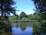
In the village of Essington, though small, and fairly recently built, there is one place, a public park called Brownshore Lakes(known locally as the pools), which are two adjacent lakes. They are the remains of three coal mining tailing and settling ponds, surrounded by woodland, it is a local meeting place, and home to waterfowlWaterfowl
Waterfowl are certain wildfowl of the order Anseriformes, especially members of the family Anatidae, which includes ducks, geese, and swans....
, and other animals thrive which around the lakes and the woods. The 'pools' is a very relaxing place where very few people go everyday.
Old Industrial Essington Village
The lakes/ponds mentioned above are now fed from surface drainage of the very large open areas around the M6 and M54. In the days of the underground mines large pumping machines and very large systems of underground pipes which linked the areas mines together were installed to drain these areas. When the mines closed, the area was surface mined using the opencast method and then refilled. On this new ground housing estates were built in the 1980s after the completion of the M54 motorway. In the former industrial use the lakes covered a larger area with the largest a tailings pond this has now been filled and is a large green field in the lakes park. During the underground mining period the coal mines of the area were linked together via the pumps and pipes to remove a very large amount of "dirty" water which needed to be pumped to the surface at this high point. Once the water had been through the tailings and settling ponds it was clean enough to go via the overflow stream down to top up the water levels of the canals. Not much left of that once large industrial system of canal goods loading areas and boat basins which have now been replaced by an Industrial park and public housing estates of Wednesfield, Ashmore Park etc. The Pools are still linked to the remaining underground pipes from the mines, however when the M6 and M54 Motorways where built the large open land areas at the Motorway junction where drained by engineers of the Agriculture Ministry of the time and the water piped through the former opencast and directed into the old tailings fields opposite the ponds. For those interested in the re-use of old Industrial land the area is a treasure. Walk on a pathway around the area you will find the remains just under the surface of old railways, factories, quarrys, mines, windmills, ammunition stores, very old moats and mounds. A local guide "Essington Parish Rights of Way Including Wulfrun Way" 2004 has been written by Bryn Whitehouse. This shows many of these features and maps.Changing the village
There have been several redevelopments on brown belt land. The new developments of houses and flats were completed in sections from late 2006 and through to 2011. The land reclaiming work of the "lakes Park" has had be continued with work to control the fires in the shallow sub surface coal under the scrub woods near the park boundary. At several sites on the surface the turf covering of the tailings pool is showing some subsidence and surface changes. There are more redevelopments that may take place from 2012 on areas of brown belt land near the central village area where various development applications for plots of land near the Motorways. On the outskirts of the central village a golf course is still being built on former opencast-mine/industrial land, the entrance and landscaping are almost complete. A very large property on the edge of the village, of about 1.64 acres is now subject of change(on sale), this is located at the boundaries with Walsall and Wolverhampton. The land around the former Clay Quarries and Tile Works near the junctions of the M6 Motorway and the M54 Motorway slip roads, will be the subject of applications commercial or residential use.Essington Parish
The Parish of Essington is quite large encompassing a village a number of recreational, industrial and farming areas and several hamlets and is part of South Staffordshire, it borders the West Midlands, "Walsall" and "Wolverhampton". Services to the parish are quite confusing, the Post Office have assigned a Wolverhampton Post-Code for mail to the area, the British Telephone have given it a Walsall 01922 Telephone prefix, the Health Authority is South Staffordshire, the Ambulance Service is West Midlands, Social Services are South Staffordshire in Codsall. All property taxes(rates) are collected by South Staffordshire at Codsall.Shops & Commerce
In the village:There is a sub-Post Office, Hairdresser, several small village shops, Sub-Post Office with Newsagents and general store, Mini-Market with off licence, Green-Grocer, two Ladies and one Gents hairdressers, a Beauty Salon, a new Mobility shop and a public house, called the Minerva Inn, and a church, St Johns, built in 1932. A primary school also named St Johns, this resides on the spot where the old church originally stood. In the old schoolhouse grounds and building the Parish Council Offices and other Adult Education with adjoining Pharmacy. The Doctors Surgery "Essington Medical Centre" is newly built in the grounds and is fully operational.
Outside the village:
Essington Fruit Farm, the local farm where fresh fruit and vegetables, are sold, in the pick your own or small farm shop. Much of the produce is locally grown in the fields around the farm. There is now a restruant serving the visitors. The area around the main carpark has a number of attractions including a summer maize maze, changing its theme from time to time. There are small farm animals, piglets, lambs with chickens and ducks etc. for the visitor to see, some can be feed or petted. A small mound near the farm shop, offers a great view of the West Midlands, and overlooking nearby Cannock Chase
Cannock Chase
Cannock Chase is a mixed area of countryside in the county of Staffordshire, England. The area has been designated as the Cannock Chase Area of Outstanding Natural Beauty. The Chase gives its name to the Cannock Chase local government district....
.
School
The main school in Essington is St Johns Primary School. Located on Hobnock Road they were first built in 1846 and became known as St John's Church of England from 1968.Brownshore Pre-School Play Group is located opposite St John's Primary School on Hobnock Road.
Sports
There are Rugby and Soccer facilities in several locations around the parish located in Bognop Road, Essington & High Hill, Essington.Still subject to cahanges the Cricket Club and Sports Club/Nursery off Long Lane, Newtown
Newtown, Staffordshire
Newtown, Staffordshire is a small village in South Staffordshire, England.Newtown lies in between Great Wyrley and Bloxwich , or more precisely, Landywood and Bloxwich , forming part of the Staffordshire/West Midlands border...
.
Recreation
A walking group meets most Fridays at about 11am outside the Minerva Public House in Wolverhampton Road and undertakes walks using some of the many public footpaths around the central village.Scouting & Girlguiding
The Scout and guide facilities have just been rebuilt (2009/2010) in Brownshore Lane.For more information visit our website: http://1st-essington.webs.com
Religious
In the village:St Johns Church Wolverhampton Road, this has many activities during the day and sometimes in the evening.
Outside the village:
The Methodist Chapel Bursnips Road (A462)
Famous people from the village
- Meera SyalMeera SyalMeera Syal MBE is a British comedienne, writer, playwright, singer, journalist, producer and actress. She rose to prominence as one of the team that created Goodness Gracious Me and became one of the UK's best-known Indian personalities portraying Sanjeev's grandmother, Ummi, in The Kumars at No...
- Comedian and Author; her debut novel Anita and MeAnita and MeAnita and Me is Meera Syal's debut novel, and was first published in 1996. It is a semi-autobiographical novel which won the Betty Trask Award....
was set in the fictional village of Tollington, based on Essington in the early 1970s. - EalhswithEalhswithEalhswith or Ealswitha was the daughter of a Mercian nobleman, Æthelred Mucil, Ealdorman of the Gaini. She was married in 868 to Alfred the Great, before he became king of Wessex. In accordance with ninth century West Saxon custom, she was not given the title of queen. -Life:Ealswith was the...
, queen consort and wife of Alfred the GreatAlfred the GreatAlfred the Great was King of Wessex from 871 to 899.Alfred is noted for his defence of the Anglo-Saxon kingdoms of southern England against the Vikings, becoming the only English monarch still to be accorded the epithet "the Great". Alfred was the first King of the West Saxons to style himself...
, the self-styled first King of England.