

Error analysis for the Global Positioning System
Encyclopedia
Global Positioning System
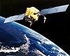
The Global Positioning System is a space-based global navigation satellite system that provides location and time information in all weather, anywhere on or near the Earth, where there is an unobstructed line of sight to four or more GPS satellites...
is important for understanding how GPS works, and for knowing what magnitude errors should be expected. The Global Positioning System makes corrections for receiver clock errors and other effects but there are still residual errors which are not corrected. The Global Positioning System (GPS) was created by the United States Department of Defense (DOD) in the 1970s. It has come to be widely used for navigation both by the U.S. military and the general public.
User vehicle position is computed by the receiver based on data received from the satellites. Errors depend on geometric dilution of precision and the sources listed in the table below.
Overview
| Source | Effect (m) |
|---|---|
| Signal arrival C/A | ±3 |
| Signal arrival P(Y) | ±0.3 |
| Ionospheric effects | ±5 |
| Ephemeris errors | ±2.5 |
| Satellite clock errors | ±2 |
| Multipath distortion | ±1 |
| Tropospheric effects | ±0.5 |
 C/A C/A |
±6.7 |
 P(Y) P(Y) |
±6.0 |

User equivalent range errors (UERE) are shown in the table. There is also a numerical error
Numerical error
In software engineering and mathematics, numerical error is the combined effect of two kinds of error in a calculation. The first is caused by the finite precision of computations involving floating-point or integer values...
with an estimated value,
 , of about 1 meter. The standard deviations,
  , for the coarse/acquisition and precise codes are also shown in the table. These standard deviations are computed by taking the square root of the sum of the squares of the individual components (i.e., RSS for root sum squares). To get the standard deviation of receiver position estimate, these range errors must be multiplied by the appropriate dilution of precision terms and then RSS'ed with the numerical error. Electronics errors are one of several accuracy-degrading effects outlined in the table above. When taken together, autonomous civilian GPS horizontal position fixes are typically accurate to about 15 meters (50 ft). These effects also reduce the more precise P(Y) code's accuracy. However, the advancement of technology means that today, civilian GPS fixes under a clear view of the sky are on average accurate to about 5 meters (16 ft) horizontally.
The term user equivalent range error (UERE) refers to the error of a component in the distance from receiver to a satellite. These UERE errors are given as ± errors thereby implying that they are unbiased or zero mean errors. These UERE errors are therefore used in computing standard deviations. The standard deviation of the error in receiver position,
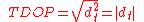
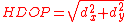
 , is computed by multiplying PDOP (Position Dilution Of Precision) by
 , the standard deviation of the user equivalent range errors.
 is computed by taking the square root of the sum of the squares of the individual component standard deviations.
PDOP is computed as a function of receiver and satellite positions. A detailed description of how to calculate PDOP is given in the section, geometric dilution of precision computation (GDOP).
 for the C/A code is given by:
The standard deviation of the error in estimated receiver position
 , again for the C/A code is given by:
The error diagram on the left shows the inter relationship of indicated receiver position, true receiver position, and the intersection of the four sphere surfaces.
Signal arrival time measurement
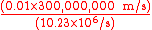
The position calculated by a GPS receiver requires the current time, the position of the satellite and the measured delay of the received signal. The position accuracy is primarily dependent on the satellite position and signal delay.To measure the delay, the receiver compares the bit sequence received from the satellite with an internally generated version. By comparing the rising and trailing edges of the bit transitions, modern electronics can measure signal offset to within about one percent of a bit pulse width,
 , or approximately 10 nanoseconds for the C/A code. Since GPS signals propagate at the speed of light
Speed of light
The speed of light in vacuum, usually denoted by c, is a physical constant important in many areas of physics. Its value is 299,792,458 metres per second, a figure that is exact since the length of the metre is defined from this constant and the international standard for time...
, this represents an error of about 3 meters.
This component of position accuracy can be improved by a factor of 10 using the higher-chiprate P(Y) signal. Assuming the same one percent of bit pulse width accuracy, the high-frequency P(Y) signal results in an accuracy of
 or about 30 centimeters.
Atmospheric effects
Inconsistencies of atmospheric conditions affect the speed of the GPS signals as they pass through the Earth's atmosphereEarth's atmosphere
The atmosphere of Earth is a layer of gases surrounding the planet Earth that is retained by Earth's gravity. The atmosphere protects life on Earth by absorbing ultraviolet solar radiation, warming the surface through heat retention , and reducing temperature extremes between day and night...
, especially the ionosphere. Correcting these errors is a significant challenge to improving GPS position accuracy. These effects are smallest when the satellite is directly overhead and become greater for satellites nearer the horizon
Horizon
The horizon is the apparent line that separates earth from sky, the line that divides all visible directions into two categories: those that intersect the Earth's surface, and those that do not. At many locations, the true horizon is obscured by trees, buildings, mountains, etc., and the resulting...
since the path through the atmosphere is longer (see airmass
Airmass
In astronomy, air mass is the optical path length through Earth’s atmosphere for light from a celestial source. As it passes through the atmosphere, light is attenuated by scattering and absorption; the more atmosphere through which it passes, the greater the attenuation. Consequently, celestial...
). Once the receiver's approximate location is known, a mathematical model can be used to estimate and compensate for these errors.
Ionospheric delay of a microwave signal depends on its frequency. It arises from ionized atmosphere (see Total electron content
Total electron content
Total electron content is an important descriptive quantity for the ionosphere of the Earth. TEC is the total number of electrons present along a path between two points, with units of electrons per square meter, where 1016 electrons/m² = 1 TEC unit .TEC is significant in determining the...
). This phenomenon is known as dispersion
Dispersion (optics)
In optics, dispersion is the phenomenon in which the phase velocity of a wave depends on its frequency, or alternatively when the group velocity depends on the frequency.Media having such a property are termed dispersive media...
and can be calculated from measurements of delays for two or more frequency bands, allowing delays at other frequencies to be estimated. Some military and expensive survey-grade civilian receivers calculate atmospheric dispersion from the different delays in the L1 and L2 frequencies, and apply a more precise correction. This can be done in civilian receivers without decrypting the P(Y) signal carried on L2, by tracking the carrier wave
Carrier wave
In telecommunications, a carrier wave or carrier is a waveform that is modulated with an input signal for the purpose of conveying information. This carrier wave is usually a much higher frequency than the input signal...
instead of the modulated
Modulation
In electronics and telecommunications, modulation is the process of varying one or more properties of a high-frequency periodic waveform, called the carrier signal, with a modulating signal which typically contains information to be transmitted...
code. To facilitate this on lower cost receivers, a new civilian code signal on L2, called L2C, was added to the Block IIR-M satellites, which was first launched in 2005. It allows a direct comparison of the L1 and L2 signals using the coded signal instead of the carrier wave.
The effects of the ionosphere generally change slowly, and can be averaged over time. Those for any particular geographical area can be easily calculated by comparing the GPS-measured position to a known surveyed location. This correction is also valid for other receivers in the same general location. Several systems send this information over radio or other links to allow L1-only receivers to make ionospheric corrections. The ionospheric data are transmitted via satellite in Satellite Based Augmentation Systems (SBAS) such as Wide Area Augmentation System
Wide Area Augmentation System
The Wide Area Augmentation System is an air navigation aid developed by the Federal Aviation Administration to augment the Global Positioning System , with the goal of improving its accuracy, integrity, and availability...
(WAAS) (available in North America and Hawaii), EGNOS (Europe and Asia) or Multi-functional Satellite Augmentation System
Multi-functional Satellite Augmentation System
Multi-functional Satellite Augmentation System is a Japanese SBAS , i.e. a satellite navigation system which supports differential GPS designed to supplement the GPS system by reporting on the reliability and accuracy of those signals...
(MSAS) (Japan), which transmits it on the GPS frequency using a special pseudo-random noise sequence (PRN), so only one receiver and antenna are required.
Humidity
Humidity
Humidity is a term for the amount of water vapor in the air, and can refer to any one of several measurements of humidity. Formally, humid air is not "moist air" but a mixture of water vapor and other constituents of air, and humidity is defined in terms of the water content of this mixture,...
also causes a variable delay, resulting in errors similar to ionospheric delay, but occurring in the troposphere
Troposphere
The troposphere is the lowest portion of Earth's atmosphere. It contains approximately 80% of the atmosphere's mass and 99% of its water vapor and aerosols....
. This effect both is more localized and changes more quickly than ionospheric effects, and is not frequency dependent. These traits make precise measurement and compensation of humidity errors more difficult than ionospheric effects.
Changes in receiver altitude also change the delay, due to the signal passing through less of the atmosphere at higher elevations. Since the GPS receiver computes its approximate altitude this error is relatively simple to correct, either by applying a function regression or correlating margin of atmospheric error to ambient pressure using a barometric altimeter.
Multipath effects
GPS signals can also be affected by multipathMultipath interference
Multipath interference is a phenomenon in the physics of waves whereby a wave from a source travels to a detector via two or more paths and, under the right condition, the two components of the wave interfere...
issues, where the radio signals reflect off surrounding terrain; buildings, canyon walls, hard ground, etc. These delayed signals can cause inaccuracy. A variety of techniques, most notably narrow correlator spacing, have been developed to mitigate multipath errors. For long delay multipath, the receiver itself can recognize the wayward signal and discard it. To address shorter delay multipath from the signal reflecting off the ground, specialized antennas (e.g., a choke ring antenna
Choke ring antenna
right|thumb|Patent Diagram of a Choke Ring AntennaA choke ring antenna is a particular form of omnidirectional antenna for use at high frequencies. It consists of a number of conductive concentric cylinders around a central antenna...
) may be used to reduce the signal power as received by the antenna. Short delay reflections are harder to filter out because they interfere with the true signal, causing effects almost indistinguishable from routine fluctuations in atmospheric delay.
Multipath effects are much less severe in moving vehicles. When the GPS antenna is moving, the false solutions using reflected signals quickly fail to converge and only the direct signals result in stable solutions.
Ephemeris and clock errors
While the ephemeris data is transmitted every 30 seconds, the information itself may be up to two hours old. If a fast time to first fixTime to first fix
Time To First Fix is a measure of the time required for a GPS receiver to acquire satellite signals and navigation data, and calculate a position solution .-Scenarios:...
(TTFF) is needed, it is possible to upload a valid ephemeris to a receiver, and in addition to setting the time, a position fix can be obtained in under ten seconds. It is feasible to put such ephemeris data on the web so it can be loaded into mobile GPS devices. See also Assisted GPS
Assisted GPS
Assisted GPS, generally abbreviated as A-GPS or aGPS, is a system which can, under certain conditions, improve the startup performance, or time-to-first-fix of a GPS satellite-based positioning system. It is used extensively with GPS-capable cellular phones as its development was accelerated by...
.
The satellite's atomic clocks experience noise and clock drift
Clock drift
Clock drift refers to several related phenomena where a clock does not run at the exact right speed compared to another clock. That is, after some time the clock "drifts apart" from the other clock. This phenomenon is also used for instance in computers to build random number generators...
errors. The navigation message contains corrections for these errors and estimates of the accuracy of the atomic clock. However, they are based on observations and may not indicate the clock's current state.
These problems tend to be very small, but may add up to a few meters (tens of feet) of inaccuracy.
For very precise positioning (e.g., in geodesy
Geodesy
Geodesy , also named geodetics, a branch of earth sciences, is the scientific discipline that deals with the measurement and representation of the Earth, including its gravitational field, in a three-dimensional time-varying space. Geodesists also study geodynamical phenomena such as crustal...
), these effects can be eliminated by differential GPS
Differential GPS
Differential Global Positioning System is an enhancement to Global Positioning System that provides improved location accuracy, from the 15-meter nominal GPS accuracy to about 10 cm in case of the best implementations....
: the simultaneous use of two or more receivers at several survey points
Benchmark (surveying)
The term bench mark, or benchmark, originates from the chiseled horizontal marks that surveyors made in stone structures, into which an angle-iron could be placed to form a "bench" for a leveling rod, thus ensuring that a leveling rod could be accurately repositioned in the same place in the future...
. In the 1990s when receivers were quite expensive, some methods of quasi-differential GPS were developed, using only one receiver but reoccupation of measuring points. At the TU Vienna the method was named qGPS and adequate software of post processing was developed.
Computation of geometric dilution of precision
The concept of geometric dilution of precision was introduced in the section, error sources and analysis. Computations were provided to show how PDOP was used and how it affected the receiver position error standard deviation.When visible GPS satellites are close together in the sky (i.e., small angular separation), the DOP values are high; when far apart, the DOP values are low. Conceptually, satellites that are close together cannot provide as much information as satellites that are widely separated. Low DOP values represent a better GPS positional accuracy due to the wider angular separation between the satellites used to calculate GPS receiver position. HDOP, VDOP, PDOP and TDOP are respectively Horizontal, Vertical, Position (3-D) and Time Dilution of Precision.
Figure 3.1 Dilution of Precision of Navstar GPS data from the U.S. Coast Guard provide a graphical indication of how geometry affect accuracy.
We now take on the task of how to compute the dilution of precision terms. As a first step in computing DOP, consider the unit vector from the receiver to satellite i with components
 ,
,  , and
, and  where the distance from receiver to the satellite,
  , is given by:
where
 denote the position of the receiver and
  denote the position of satellite i. These x, y, and z components may be components in a North, East, Down coordinate system a South, East, Up coordinate system or other convenient system. Formulate the matrix A as:
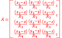
The first three elements of each row of A are the components of a unit vector from the receiver to the indicated satellite. The elements in the fourth column are c where c denotes the speed of light. Formulate the matrix, Q, as

This computation is in accordance with Chapter 11 of The global positioning system by Parkinson and Spilker where the weighting matrix, P, has been set to the identity matrix. The elements of the Q matrix are designated as:
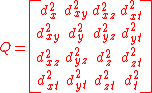
The Greek letter
 is used quite often where we have used d. However the elements of the Q matrix do not represent variances and covariances as they are defined in probability and statistics. Instead they are strictly geometric terms. Therefore d as in dilution of precision is used. PDOP, TDOP and GDOP are given by
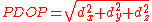 ,
, , and
, and
in agreement with "Section 1.4.9 of PRINCIPLES OF SATELLITE POSITIONING".
The horizontal dilution of precision,
 , and the vertical dilution of precision,
  , are both dependent on the coordinate system used. To correspond to the local horizon plane and the local vertical, x, y, and z should denote positions in either a North, East, Down coordinate system or a South, East, Up coordinate system.
Derivation of equations for computing geometric dilution of precision
The equations for computing the geometric dilution of precision terms have been described in the previous section. This section describes the derivation of these equations. The method used here is similar to that used in "Global Positioning System (preview) by Parkinson and Spiker"Consider the position error vector,
 , defined as the vector from the intersection of the four sphere surfaces corresponding to the pseudoranges to the true position of the receiver.
 where bold denotes a vector and
  ,
,  , and
, and  denote unit vectors along the x, y, and z axes respectively. Let
  denote the time error, the true time minus the receiver indicated time. Assume that the mean value of the three components of
  and
and  are zero.
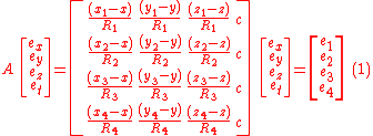
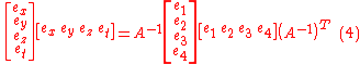
where
 are the errors in pseudoranges 1 through 4 respectively. This equation comes from linearizing the equation relating pseudoranges to receiver position, satellite positions, and receiver clock errors as shown in.
Multiplying both sides by
 there results
 .
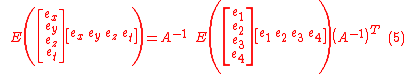
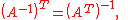
.Transposing both sides:
 .
.Post multiplying the matrices on both sides of equation (2) by the corresponding matrices in equation (3), there results
 .
.Taking the expected value of both sides and taking the non-random matrices outside the expectation operator, E, there results:
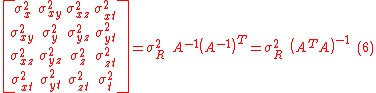
Assuming the pseudorange errors are uncorrelated and have the same variance, the covariance matrix on the right side can be expressed as a scalar times the identity matrix. Thus
since
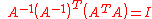
Note:
 since
since 
Substituting for
 there follows
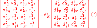
From equation (7), it follows that the variances of indicated receiver position and time are
 and
and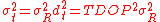
The remaining position and time error variance terms follow in a straightforward manner.
Selective availability
GPS includes a (currently disabled) feature called Selective Availability (SA) that adds intentional, time varying errors of up to 100 meters (328 ft) to the publicly available navigation signals. This was intended to deny an enemy the use of civilian GPS receivers for precision weapon guidance.SA errors are actually pseudorandom, generated by a cryptographic algorithm from a classified seed key
Key (cryptography)
In cryptography, a key is a piece of information that determines the functional output of a cryptographic algorithm or cipher. Without a key, the algorithm would produce no useful result. In encryption, a key specifies the particular transformation of plaintext into ciphertext, or vice versa...
available only to authorized users (the U.S. military, its allies and a few other users, mostly government) with a special military GPS receiver. Mere possession of the receiver is insufficient; it still needs the tightly controlled daily key.
Before it was turned off on May 2, 2000, typical SA errors were about 50 m (164 ft) horizontally and about 100 m (328 ft) vertically. Because SA affects every GPS receiver in a given area almost equally, a fixed station with an accurately known position can measure the SA error values and transmit them to the local GPS receivers so they may correct their position fixes. This is called Differential GPS or DGPS. DGPS also corrects for several other important sources of GPS errors, particularly ionospheric delay, so it continues to be widely used even though SA has been turned off. The ineffectiveness of SA in the face of widely available DGPS was a common argument for turning off SA, and this was finally done by order of President Clinton in 2000.
DGPS services are widely available from both commercial and government sources. The latter include WAAS and the U.S. Coast Guard's network of LF
Low frequency
Low frequency or low freq or LF refers to radio frequencies in the range of 30 kHz–300 kHz. In Europe, and parts of Northern Africa and of Asia, part of the LF spectrum is used for AM broadcasting as the longwave band. In the western hemisphere, its main use is for aircraft beacon,...
marine navigation beacons. The accuracy of the corrections depends on the distance between the user and the DGPS receiver. As the distance increases, the errors at the two sites will not correlate as well, resulting in less precise differential corrections.
During the 1990-91 Gulf War
Gulf War
The Persian Gulf War , commonly referred to as simply the Gulf War, was a war waged by a U.N.-authorized coalition force from 34 nations led by the United States, against Iraq in response to Iraq's invasion and annexation of Kuwait.The war is also known under other names, such as the First Gulf...
, the shortage of military GPS units caused many troops and their families to buy readily available civilian units. Selective Availability significantly impeded the U.S. military's own battlefield use of these GPS, so the military made the decision to turn it off for the duration of the war.
In the 1990s, the FAA
Federal Aviation Administration
The Federal Aviation Administration is the national aviation authority of the United States. An agency of the United States Department of Transportation, it has authority to regulate and oversee all aspects of civil aviation in the U.S...
started pressuring the military to turn off SA permanently. This would save the FAA millions of dollars every year in maintenance of their own radio navigation
Radio navigation
Radio navigation or radionavigation is the application of radio frequencies to determine a position on the Earth. Like radiolocation, it is a type of radiodetermination.The basic principles are measurements from/to electric beacons, especially...
systems. The amount of error added was "set to zero" at midnight on May 1, 2000 following an announcement by U.S. President Bill Clinton
Bill Clinton
William Jefferson "Bill" Clinton is an American politician who served as the 42nd President of the United States from 1993 to 2001. Inaugurated at age 46, he was the third-youngest president. He took office at the end of the Cold War, and was the first president of the baby boomer generation...
, allowing users access to the error-free L1 signal. Per the directive, the induced error of SA was changed to add no error to the public signals (C/A code). Clinton's executive order required SA to be set to zero by 2006; it happened in 2000 once the U.S. military developed a new system that provides the ability to deny GPS (and other navigation services) to hostile forces in a specific area of crisis without affecting the rest of the world or its own military systems.
Selective Availability is still a system capability of GPS, and could, in theory, be reintroduced at any time. In practice, in view of the hazards and costs this would induce for U.S. and foreign shipping, it is unlikely to be reintroduced, and various government agencies, including the FAA, have stated that it is not intended to be reintroduced.
One interesting side effect of the Selective Availability hardware is the capability to add corrections to the outgoing signal of the GPS cesium
Caesium
Caesium or cesium is the chemical element with the symbol Cs and atomic number 55. It is a soft, silvery-gold alkali metal with a melting point of 28 °C , which makes it one of only five elemental metals that are liquid at room temperature...
and rubidium
Rubidium
Rubidium is a chemical element with the symbol Rb and atomic number 37. Rubidium is a soft, silvery-white metallic element of the alkali metal group. Its atomic mass is 85.4678. Elemental rubidium is highly reactive, with properties similar to those of other elements in group 1, such as very rapid...
atomic clocks to an accuracy of approximately 2 × 10⁻¹³. This represented a significant improvement over the raw accuracy of the clocks.
On 19 September 2007, the United States Department of Defense
United States Department of Defense
The United States Department of Defense is the U.S...
announced that future GPS III
GPS modernization
The United States' Global Positioning System , having reached Fully Operational Capability on July 17, 1995, has completed its original design goals. However, additional advances in technology and new demands on the existing system led to the effort to modernize the GPS system. Announcements from...
satellites will not be capable of implementing SA, eventually making the policy permanent.
Antispoofing
Another restriction on GPS, antispoofing, remains on. This encrypts the P-code so that it cannot be mimicked by a transmitter sending false information. Few civilian receivers have ever used the P-code, and the accuracy attainable with the public C/A code is so much better than originally expected (especially with DGPSDifferential GPS
Differential Global Positioning System is an enhancement to Global Positioning System that provides improved location accuracy, from the 15-meter nominal GPS accuracy to about 10 cm in case of the best implementations....
) that the antispoof policy has relatively little effect on most civilian users. Turning off antispoof would primarily benefit surveyors and some scientists who need extremely precise positions for experiments such as tracking tectonic plate motion.
Relativity
A number of sources of error exist due to relativisticTheory of relativity
The theory of relativity, or simply relativity, encompasses two theories of Albert Einstein: special relativity and general relativity. However, the word relativity is sometimes used in reference to Galilean invariance....
effects that would render the system useless if uncorrected. Three relativistic effects are the time dilation, gravitational frequency shift, and eccentricity effects. For example, the relativistic time slowing due to the speed of the satellite of about 1 part in 1010, the gravitational time dilation that makes a satellite run about 5 parts in 1010 faster than an Earth based clock, and the Sagnac effect
Sagnac effect
The Sagnac effect , named after French physicist Georges Sagnac, is a phenomenon encountered in interferometry that is elicited by rotation. The Sagnac effect manifests itself in a setup called ring interferometry. A beam of light is split and the two beams are made to follow a trajectory in...
due to rotation relative to receivers on Earth. These topics are examined below, one at a time.
Special and general relativity
According to the theory of relativity, due to their constant movement and height relative to the Earth-centered, non-rotating approximately inertial reference frame, the clocks on the satellites are affected by their speed. Special relativitySpecial relativity
Special relativity is the physical theory of measurement in an inertial frame of reference proposed in 1905 by Albert Einstein in the paper "On the Electrodynamics of Moving Bodies".It generalizes Galileo's...
predicts that the frequency of the atomic clocks moving at GPS orbital speeds will tick more slowly than stationary ground clocks by a factor of
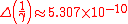
 , or result in a delay of about 7 μs/day, where the orbital velocity is v = 4 km/s, and c = the speed of light. The time dilation
Time dilation
In the theory of relativity, time dilation is an observed difference of elapsed time between two events as measured by observers either moving relative to each other or differently situated from gravitational masses. An accurate clock at rest with respect to one observer may be measured to tick at...
effect has been measured and verified using the GPS.
The effect of gravitational frequency shift on the GPS due to general relativity
General relativity
General relativity or the general theory of relativity is the geometric theory of gravitation published by Albert Einstein in 1916. It is the current description of gravitation in modern physics...
is that a clock closer to a massive object will be slower than a clock farther away. Applied to the GPS, the receivers are much closer to Earth than the satellites, causing the GPS clocks to be faster by a factor of 5×10^(-10), or about 45.9 μs/day. This gravitational frequency shift is noticeable.
When combining the time dilation and gravitational frequency shift, the discrepancy is about 38 microseconds per day, a difference of 4.465 parts in 1010. Without correction, errors in the initial pseudorange of roughly 10 km/day would accumulate. This initial pseudorange error is corrected in the process of solving the navigation equations. In addition the elliptical, rather than perfectly circular, satellite orbits cause the time dilation and gravitational frequency shift effects to vary with time. This eccentricity effect causes the clock rate difference between a GPS satellite and a receiver to increase or decrease depending on the altitude of the satellite.
To compensate for the discrepancy, the frequency standard on board each satellite is given a rate offset prior to launch, making it run slightly slower than the desired frequency on Earth; specifically, at 10.22999999543 MHz instead of 10.23 MHz. Since the atomic clocks on board the GPS satellites are precisely tuned, it makes the system a practical engineering application of the scientific theory of relativity in a real-world environment. Placing atomic clocks on artificial satellites to test Einstein's general theory was proposed by Friedwardt Winterberg
Friedwardt Winterberg
Friedwardt Winterberg is a German-American theoretical physicist and research professor at the University of Nevada, Reno. With more than 260 publications and three books, he is known for his research in areas spanning general relativity, Planck scale physics, nuclear fusion, and plasmas...
in 1955.
Calculation of time dilation
To calculate the amount of daily time dilation experienced by GPS satellites relative to Earth we need to separately determine the amounts due to special relativitySpecial relativity
Special relativity is the physical theory of measurement in an inertial frame of reference proposed in 1905 by Albert Einstein in the paper "On the Electrodynamics of Moving Bodies".It generalizes Galileo's...
(velocity) and general relativity
General relativity
General relativity or the general theory of relativity is the geometric theory of gravitation published by Albert Einstein in 1916. It is the current description of gravitation in modern physics...
(gravity) and add them together.
The amount due to velocity will be determined using the Lorentz transformation
Lorentz transformation
In physics, the Lorentz transformation or Lorentz-Fitzgerald transformation describes how, according to the theory of special relativity, two observers' varying measurements of space and time can be converted into each other's frames of reference. It is named after the Dutch physicist Hendrik...
. This will be:

For small values of v/c, by using binomial expansion this approximates to:

The GPS satellites move at relative to Earth's center. We thus determine:

This difference below 1 of represents the fraction by which the satellites' clocks move slower than Earth's. It is then multiplied by the number of nanoseconds in a day:

That is, the satellites' clocks lose 7,214 nanoseconds a day due to special relativity
Special relativity
Special relativity is the physical theory of measurement in an inertial frame of reference proposed in 1905 by Albert Einstein in the paper "On the Electrodynamics of Moving Bodies".It generalizes Galileo's...
effects.
- Note that this speed of is measured relative to Earth's center rather than its surface where the GPS receivers (and users) are. This is because Earth's equipotential makes net time dilation equal across its geodesic surface. That is, the combination of Special and General effects make the net time dilation at the equator equal to that of the poles, which in turn are at rest relative to the center. Hence we use the center as a reference point to represent the entire surface.
The amount of dilation due to gravity will be determined using the gravitational time dilation
Gravitational time dilation
Gravitational time dilation is the effect of time passing at different rates in regions of different gravitational potential; the lower the gravitational potential, the more slowly time passes...
equation:

For small values of M/r, by using binomial expansion this approximates to:

We are again only interested in the fraction below 1, and in the difference between Earth and the satellites. To determine this difference we take:
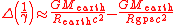
Earth has a radius of 6,357 km (at the poles) making Rearth = 6,357,000 m and the satellites have an altitude of 20,184 km making their orbit radius Rgps = 26,541,000 m. Substituting these in the above equation, with Mearth = , G = , and c = (all in SI
International System of Units
The International System of Units is the modern form of the metric system and is generally a system of units of measurement devised around seven base units and the convenience of the number ten. The older metric system included several groups of units...
units), gives:
This represents the fraction by which the satellites' clocks move faster than Earth's. It is then multiplied by the number of nanoseconds in a day:

That is, the satellites' clocks gain 45,850 nanoseconds a day due to general relativity
General relativity
General relativity or the general theory of relativity is the geometric theory of gravitation published by Albert Einstein in 1916. It is the current description of gravitation in modern physics...
effects. These effects are added together to give (rounded to 10 ns):
- 45850 - 7210 = 38640 ns
Hence the satellites' clocks gain approximately 38,640 nanoseconds a day or 38.6 μs per day due to relativity effects in total.
In order to compensate for this gain, a GPS clock's frequency needs to be slowed by the fraction:
- - =
This fraction is subtracted from 1 and multiplied by the pre-adjusted clock frequency of 10.23 MHz:
- (1 - ) × 10.23 = 10.22999999543
That is, we need to slow the clocks down from 10.23 MHz to 10.22999999543 MHz in order to negate the effects of relativity.
Sagnac distortion
GPS observation processing must also compensate for the Sagnac effect. The GPS time scale is defined in an inertial system but observations are processed in an Earth-centered, Earth-fixedECEF
ECEF stands for Earth-Centered, Earth-Fixed, and is a Cartesian coordinate system, and is sometimes known as a "conventional terrestrial" system. It represents positions as an X, Y, and Z coordinate. The point is defined as the center of mass of the earth, hence the name Earth-Centered...
(co-rotating) system, a system in which simultaneity
Simultaneity
Simultaneity is the property of two events happening at the same time in at least one frame of reference. The word derives from the Latin simul, at the same time plus the suffix -taneous, abstracted from spontaneous .The noun simult means a supernatural coincidence, two or more divinely...
is not uniquely defined. A Lorentz transformation
Lorentz transformation
In physics, the Lorentz transformation or Lorentz-Fitzgerald transformation describes how, according to the theory of special relativity, two observers' varying measurements of space and time can be converted into each other's frames of reference. It is named after the Dutch physicist Hendrik...
is thus applied to convert from the inertial system to the ECEF system. The resulting signal run time correction has opposite algebraic signs for satellites in the Eastern and Western celestial hemispheres. Ignoring this effect will produce an east-west error on the order of hundreds of nanoseconds, or tens of meters in position.
Natural sources of interference
Since GPS signals at terrestrial receivers tend to be relatively weak, natural radio signals or scattering of the GPS signals can desensitizeDesensitization (telecommunications)
For telecommunications, desensitization is a form of electromagnetic interference where a radio receiver is unable to receive a weak radio signal that it might otherwise be able to receive when there is no interference...
the receiver, making acquiring and tracking the satellite signals difficult or impossible.
Space weather
Space weather
Space weather is the concept of changing environmental conditions in near-Earth space or thespace from the Sun's atmosphere to the Earth's atmosphere. It is distinct from the concept ofweather within the Earth's planetary atmosphere...
degrades GPS operation in two ways, direct interference by solar radio burst noise in the same frequency band or by scattering of the GPS radio signal in ionospheric irregularities referred to as scintillation. Both forms of degradation follow the 11 year solar cycle
Solar cycle
The solar cycle, or the solar magnetic activity cycle, is a periodic change in the amount of irradiation from the Sun that is experienced on Earth. It has a period of about 11 years, and is one component of solar variation, the other being aperiodic fluctuations. Solar variation causes changes in...
and are a maximum at sunspot maximum although they can occur at anytime. Solar radio bursts are associated with solar flares and Coronal Mass Ejections (CMEs) and their impact can affect reception over the half of the Earth facing the sun. Scintillation occurs most frequently at tropical latitudes where it is a night time phenomenon. It occurs less frequently at high latitudes or mid-latitudes where magnetic storms can lead to scintillation. In addition to producing scintillation, magnetic storms can produce strong ionospheric gradients that degrade the accuracy of SBAS systems.
Artificial sources of interference
In automotive GPS receivers, metallic features in windshields, such as defrosters, or car window tinting films can act as a Faraday cageFaraday cage
A Faraday cage or Faraday shield is an enclosure formed by conducting material or by a mesh of such material. Such an enclosure blocks out external static and non-static electric fields...
, degrading reception just inside the car.
Man-made EMI
Electromagnetic interference
Electromagnetic interference is disturbance that affects an electrical circuit due to either electromagnetic induction or electromagnetic radiation emitted from an external source. The disturbance may interrupt, obstruct, or otherwise degrade or limit the effective performance of the circuit...
(electromagnetic interference) can also disrupt or jam
Radio jamming
Radio jamming is the transmission of radio signals that disrupt communications by decreasing the signal to noise ratio. Unintentional jamming occurs when an operator transmits on a busy frequency without first checking whether it is in use, or without being able to hear stations using the frequency...
GPS signals. In one well-documented case it was impossible to receive GPS signals in the entire harbor of Moss Landing
Moss Landing, California
Moss Landing is a census-designated place in Monterey County, California, United States. Moss Landing is located on the Pajaro Valley Consolidated Railroad north-northeast of Monterey, at an elevation of 10 feet . As of the 2010 census, the CDP population was 204, down from 300 at the 2000...
, California
California
California is a state located on the West Coast of the United States. It is by far the most populous U.S. state, and the third-largest by land area...
due to unintentional jamming caused by malfunctioning TV antenna preamplifiers. Intentional jamming is also possible. Generally, stronger signals can interfere with GPS receivers when they are within radio range or line of sight. In 2002 a detailed description of how to build a short-range GPS L1 C/A jammer was published in the online magazine Phrack
Phrack
Phrack is an ezine written by and for hackers first published November 17, 1985. Described by Fyodor as "the best, and by far the longest running hacker zine," the magazine is open for contributions by anyone who desires to publish remarkable works or express original ideas on the topics of interest...
.
The U.S. government
Federal government of the United States
The federal government of the United States is the national government of the constitutional republic of fifty states that is the United States of America. The federal government comprises three distinct branches of government: a legislative, an executive and a judiciary. These branches and...
believes that such jammers were used occasionally during the 2001 war in Afghanistan
War in Afghanistan (2001–present)
The War in Afghanistan began on October 7, 2001, as the armed forces of the United States of America, the United Kingdom, Australia, and the Afghan United Front launched Operation Enduring Freedom...
, and the U.S. military claims to have destroyed six GPS jammers during the Iraq War, including one that was destroyed with a GPS-guided bomb. A GPS jammer is relatively easy to detect and locate, making it an attractive target for anti-radiation missile
Anti-radiation missile
An anti-radiation missile is a missile which is designed to detect and home on an enemy radio emission source. Typically these are designed for use against an enemy radar, although jammers and even radios used for communication can also be targeted in this manner.- Air-to-Ground :Most ARM designs...
s. The UK Ministry of Defence tested a jamming system in the UK's West Country on 7 and 8 June 2007.
Some countries allow the use of GPS repeaters to allow the reception of GPS signals indoors and in obscured locations; however, under EU and UK laws, the use of these is prohibited as the signals can cause interference to other GPS receivers that receive data from both GPS satellites and the repeater.
Due to the potential for both natural and man-made noise, numerous techniques continue to be developed to deal with the interference. The first is to not rely on GPS as a sole source. According to John Ruley, "IFR
Instrument flight rules
Instrument flight rules are one of two sets of regulations governing all aspects of civil aviation aircraft operations; the other are visual flight rules ....
pilots should have a fallback plan in case of a GPS malfunction". Receiver Autonomous Integrity Monitoring (RAIM) is a feature included in some receivers, designed to provide a warning to the user if jamming or another problem is detected. The U.S. military has also deployed since 2004 their Selective Availability / Anti-Spoofing Module
SAASM
A Selective Availability Anti-spoofing Module is used by military Global Positioning System receivers to allow decryption of precision GPS coordinates, while the accuracy of civilian GPS receivers may be reduced by the United States military through Selective Availability...
(SAASM) in the Defense Advanced GPS Receiver
Defense Advanced GPS Receiver
The Defense Advanced GPS Receiver is a handheld GPS receiver used by the United States Department of Defense and select foreign military services...
(DAGR). In demonstration videos the DAGR was shown to detect jamming and maintain its lock on the encrypted GPS signals during interference which caused civilian receivers to lose lock.
External links
- GPS.gov—General public education website created by the U.S. Government
- U.S. Army Corps of Engineers manual: NAVSTAR HTML and PDF (22.6 MB, 328 pages)
- GPS SPS Performance Standard—The official Standard Positioning Service specification (2008 version).
- GPS SPS Performance Standard—The official Standard Positioning Service specification (2001 version).
- GPS PPS Performance Standard—The official Precise Positioning Service specification.