

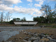
Elizabethton Covered Bridge
Encyclopedia
Covered bridge
A covered bridge is a bridge with enclosed sides and a roof, often accommodating only a single lane of traffic. Most covered bridges are wooden; some newer ones are concrete or metal with glass sides...
over the Doe River
Doe River
The Doe River is a naturally flowing river in northeast Tennessee that forms in Carter County near the North Carolina line, just south of Roan Mountain State Park.-Hydrography:...
in Elizabethton
Elizabethton, Tennessee
Elizabethton is the county seat of Carter County, Tennessee, United States. Elizabethton is also the historical site both of the first independent American government located west of both the Eastern Continental Divide and the original thirteen British American colonies.Elizabethton is also the...
, the county seat of Carter County
Carter County, Tennessee
Carter County is a county located in the U.S. state of Tennessee. As of 2010, the population was 57,424. Its county seat is Elizabethton.Carter County is part of the Johnson City Metropolitan Statistical Area, which is a component of the Johnson City–Kingsport–Bristol, TN-VA Combined...
, Tennessee
Tennessee
Tennessee is a U.S. state located in the Southeastern United States. It has a population of 6,346,105, making it the nation's 17th-largest state by population, and covers , making it the 36th-largest by total land area...
.
The Elizabethton Covered Bridge was constructed in 1882 and connects 3rd Street and Hattie Avenue.
Features
Structurally, the Elizabethton Covered Bridge contains one span, a covered wooden Howe TrussTruss
In architecture and structural engineering, a truss is a structure comprising one or more triangular units constructed with straight members whose ends are connected at joints referred to as nodes. External forces and reactions to those forces are considered to act only at the nodes and result in...
(typically constructed of timber diagonals and iron verticals) that is 137 feet (41.8 m) long. The total length is 154.3 feet (47 m). The covered bridge contains one traffic lane and a single walkway, while the curb-to-curb width is 16.4 feet (5 m) and the out-to-out width is 20.4 feet (6.2 m). The bridge substructure is masonry
Masonry
Masonry is the building of structures from individual units laid in and bound together by mortar; the term masonry can also refer to the units themselves. The common materials of masonry construction are brick, stone, marble, granite, travertine, limestone; concrete block, glass block, stucco, and...
, stone, and concrete
Concrete
Concrete is a composite construction material, composed of cement and other cementitious materials such as fly ash and slag cement, aggregate , water and chemical admixtures.The word concrete comes from the Latin word...
. Each end of the bridge features a projecting truncated gable
Gable
A gable is the generally triangular portion of a wall between the edges of a sloping roof. The shape of the gable and how it is detailed depends on the structural system being used and aesthetic concerns. Thus the type of roof enclosing the volume dictates the shape of the gable...
d roofline.
While allowing for pedestrian
Pedestrian
A pedestrian is a person traveling on foot, whether walking or running. In some communities, those traveling using roller skates or skateboards are also considered to be pedestrians. In modern times, the term mostly refers to someone walking on a road or footpath, but this was not the case...
and bicycle
Bicycle
A bicycle, also known as a bike, pushbike or cycle, is a human-powered, pedal-driven, single-track vehicle, having two wheels attached to a frame, one behind the other. A person who rides a bicycle is called a cyclist, or bicyclist....
transit over the Doe River, the Elizabethton Covered Bridge is now closed to all motor vehicle traffic.
History: "five dollar bridge"
As the county seat, Elizabethton grew throughout the 19th century. However, Lynn Mountain hemmed it in to the east and the Watauga RiverWatauga River
The Watauga River is a large stream of western North Carolina and East Tennessee. It is 60 miles long with its headwaters on the slopes of Grandfather Mountain and Peak Mountain in Watauga County, North Carolina.-Hydrography:...
lay to the north. The Doe River flooded often and limited growth to the south. To span westward, to the site of the current downtown, the city would need a bridge over the Doe River. After extensive debate, in 1882 the Carter County Court approved $3,000 for the bridge and $300 for approaches. The court appointed a committee to select a site for the bridge. However, the committee encountered an unexpected problem — the men could not find a qualified contractor to erect the bridge.
After county officials were unable to find a bridge contractor, a local doctor, E.E. Hunter, accepted the contract and hired experienced people to work on the bridge. Hunter selected Thomas Matson, who had been an engineer for the narrow gauge Tweetsie Railroad
East Tennessee and Western North Carolina Railroad
The East Tennessee and Western North Carolina Railroad , affectionately called the "Tweetsie" in reference to the sound of its steam whistles, was primarily a railroad established in 1866 for the purpose of serving the mines at Cranberry, North Carolina.The narrow gauge portion of the ET&WNC was...
as an engineer and architect. Hunter referred to the bridge as his "five dollar bridge" since he made a profit of $5 as contractor.
Although logs from a lumber operation and a barn were thrown against the covered bridge and its supports during a disastrous flood in 1901, this was the only major bridge in the area to survive.
June covered bridge festival, parades
Roan Mountain (Roan Highlands)
Roan Mountain is the highpoint of the Roan-Unaka Range of the Southern Appalachian Mountains, located in the Southeastern United States. The mountain is clad in a dense stand of Southern Appalachian spruce-fir forest, and includes the world's largest natural rhododendron garden, and the longest...
, the Doe River eventually flows by the East Side neighborhood in Elizabethton and parallel with Tennessee State Route 67
Tennessee State Route 67
State Route 67 is a state-maintained highway in northeastern Tennessee, including a four-lane divided highway segments in both Washington County and Carter County, and part of a significant two-lane segment passing over the Butler Bridge some above the TVA Watauga Reservoir near Butler in Johnson...
before passing underneath the historic covered bridge. Connecting 3rd Street to Hattie Avenue, the Elizabethton Covered Bridge, although now closed to motorvehicle traffic, is still open to both bicycles and pedestrians throughout the year.
Elizabethton Covered Bridge is adjacent to a large city park area with walking trails, baseball diamonds, and picinic areas and the cobered bridge spans the Doe River connecting this city park area with the Elizabethton downtown business district.
Most of Elizabethton's downtown is listed on the National Register of Historic Places
National Register of Historic Places
The National Register of Historic Places is the United States government's official list of districts, sites, buildings, structures, and objects deemed worthy of preservation...
for its historical and architectural merits. The Elizabethton Historic District contains a variety of properties ranging in age from the late 18th century through the 1930s. However, the Elizabethton Covered Bridge is an important focal point and a well-known landmark in the state that pre-dates much of the downtown construction fueled by the rayon boom of the mid-to-late 1920s. In addition to the Covered Bridge, the downtown historical district also contains the 1928 Elk Avenue concrete arch bridge, and just a little further downstream on the Doe River, Tennessee State Route 67
Tennessee State Route 67
State Route 67 is a state-maintained highway in northeastern Tennessee, including a four-lane divided highway segments in both Washington County and Carter County, and part of a significant two-lane segment passing over the Butler Bridge some above the TVA Watauga Reservoir near Butler in Johnson...
passes another similar concrete arch bridge locally known as the Broad Street Bridge.
Elizabethton celebrates in the downtown business area for one week each June with the Elizabethton Covered Bridge Days featuring country and gospel music performances, activities for children, Elk Avenue car club show, and many food and crafts vendors. The Elizabethton Covered Bridge is also along the Elk Avenue route for the annual July 4 and Christmas parades.
Connection with U.S. Interstate Highway System


 Interstate 26
Interstate 26
Interstate 26 is a nominally east–west main route of the Interstate Highway System in the Southeastern United States. I-26 runs from the junction of U.S. Route 11W and U.S. Route 23 in Kingsport, Tennessee, generally southeastward to U.S. Route 17 in Charleston, South Carolina...
Exit 24 at Johnson City
Johnson City, Tennessee
Johnson City is a city in Carter, Sullivan, and Washington counties in the U.S. state of Tennessee, with most of the city being in Washington County...
then east

 US 321/Tennessee State Route 67
Tennessee State Route 67
State Route 67 is a state-maintained highway in northeastern Tennessee, including a four-lane divided highway segments in both Washington County and Carter County, and part of a significant two-lane segment passing over the Butler Bridge some above the TVA Watauga Reservoir near Butler in Johnson...
to Elizabethton
Elizabethton, Tennessee
Elizabethton is the county seat of Carter County, Tennessee, United States. Elizabethton is also the historical site both of the first independent American government located west of both the Eastern Continental Divide and the original thirteen British American colonies.Elizabethton is also the...
, then
straight on Elk Avenue to downtown business district.