
.gif)
Elephant Island (South Shetland Islands)
Encyclopedia
Elephant Island is an ice-covered, mountainous island off the coast of Antarctica in the outer reaches of the South Shetland Islands
in the Southern Ocean
. Its name was given by early explorers sighting elephant seal
s on its shores. It lies 1253 kilometres (778.6 mi) west-southwest of South Georgia, 935 kilometres (581 mi) south of the Falkland Islands
, and 885 kilometres (549.9 mi) southeast of Cape Horn
. It is within the Antarctic claims of Argentina
, Chile
and the UK
. Brazil
has two refuges on the island, Goeldi and Wiltgen, supporting the work of up to six researchers each during the summer.
. Significant named features of the island are Cape Yelcho
, Cape Valentine
and Cape Lookout
at its northeastern and southernmost extremes, and Point Wild
, a spit of land on its northern coast. The Endurance Glacier
is the main discharge glacier on the island.
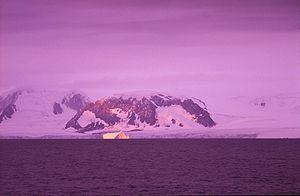 The island supports no significant flora or native fauna although migratory Gentoo penguin
s and seals may be found on its shores, and Chinstrap penguin
s nest there in season. A lack of safe anchor
age has prevented any permanent human settlements being formed, despite the island being well placed to support scientific, fishing
and whaling
activities in the area.
Elephant Island’s name can be attributed to both its elephant head-like appearance and the sighting of elephant seal
s by Captain George Powell in 1821, one of the earliest sightings of the island. Its weather is normally foggy with much snow. Additionally, winds can reach speeds up to 100 miles per hour (160.9 km/h) on the frigid island.
 The island is most famous as the desolate refuge of Ernest Shackleton
and his crew in 1916. Following the loss of their ship Endurance
in Weddell Sea
ice, the 28 exhausted men reached Elephant Island after a harrowing ordeal on drifting ice floes. They established a camp at a place they called Point Wild where they were able to regain some strength.
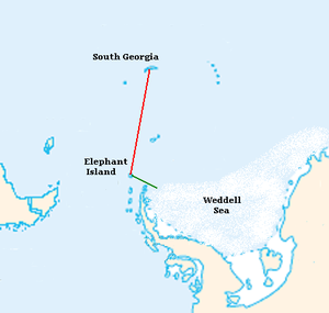
Realizing that there was no chance of rescue by any passing ships, Shackleton decided to travel to South Georgia
where he knew there was a whaling station. In one of the most incredible feats in the history of sailing and navigation, Shackleton sailed off with five other men on an 800 miles (1,287 km) voyage in the open lifeboat James Caird
on Easter Monday, April 24, 1916, arriving at South Georgia almost two weeks later. His second in command, John Robert Francis “Frank” Wild
remained in charge of the 21 other men on Elephant Island for more than four months while Shackleton led attempts to return with a rescue ship. In his memoir Wild recalled “We gave them three hearty cheers and watched the boat getting smaller and smaller in the distance. Then seeing some of the party in tears, I immediately set them all to work.”
Indeed, there was much work for the stranded party. Because the island had no natural source of shelter, they constructed a shack and wind blocks from their remaining two lifeboats and pieces of canvas tents. Blubber lamps were used for lighting. Expedition physicist Reginald James composed the following verses out of gratitude for Wild's leadership:
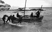
They hunted for penguins and seals, neither of which were plentiful during the autumn and winter months. The crew, many of whom were already ill and frost-bitten, were now also in danger of starvation. After four and a half months of waiting, one of the stranded men spotted a ship on August 30, 1916. The ship, led by Shackleton, was the borrowed tug boat Yelcho, from Punta Arenas, Chile
, commanded by Luis Pardo
, which broke through the ice surrounding the island to finally rescue all of the men who set out on the original expedition.
According to Frank Worsley
, Shackleton's captain, the men pronounced the island with a silent 't' and an 'h' prefixed, which makes it into Hell-of-an-Island.
South Shetland Islands
The South Shetland Islands are a group of Antarctic islands, lying about north of the Antarctic Peninsula, with a total area of . By the Antarctic Treaty of 1959, the Islands' sovereignty is neither recognized nor disputed by the signatories and they are free for use by any signatory for...
in the Southern Ocean
Southern Ocean
The Southern Ocean comprises the southernmost waters of the World Ocean, generally taken to be south of 60°S latitude and encircling Antarctica. It is usually regarded as the fourth-largest of the five principal oceanic divisions...
. Its name was given by early explorers sighting elephant seal
Elephant seal
Elephant seals are large, oceangoing seals in the genus Mirounga. There are two species: the northern elephant seal and the southern elephant seal . Both were hunted to the brink of extinction by the end of the 19th century, but numbers have since recovered...
s on its shores. It lies 1253 kilometres (778.6 mi) west-southwest of South Georgia, 935 kilometres (581 mi) south of the Falkland Islands
Falkland Islands
The Falkland Islands are an archipelago in the South Atlantic Ocean, located about from the coast of mainland South America. The archipelago consists of East Falkland, West Falkland and 776 lesser islands. The capital, Stanley, is on East Falkland...
, and 885 kilometres (549.9 mi) southeast of Cape Horn
Cape Horn
Cape Horn is the southernmost headland of the Tierra del Fuego archipelago of southern Chile, and is located on the small Hornos Island...
. It is within the Antarctic claims of Argentina
Argentine Antarctica
Argentine Antarctica is a sector of Antarctica claimed by Argentina as part of its national territory. The Argentine Antarctic region, consisting of the Antarctic Peninsula and a triangular section extending to the South Pole, is delimited by the 25° West and 74° West meridians and the 60° South...
, Chile
Antártica
The Chilean Antarctic Territory is the territory in Antarctica claimed by Chile. The Chilean Antarctic Territory ranges from 53°W to 90°W and from the South Pole to 60°S, partially overlapping Argentine and British Antarctic claims...
and the UK
British Antarctic Territory
The British Antarctic Territory is a sector of Antarctica claimed by the United Kingdom as one of its 14 British Overseas Territories. It comprises the region south of 60°S latitude and between longitudes and , forming a wedge shape that extends to the South Pole...
. Brazil
Brazil
Brazil , officially the Federative Republic of Brazil , is the largest country in South America. It is the world's fifth largest country, both by geographical area and by population with over 192 million people...
has two refuges on the island, Goeldi and Wiltgen, supporting the work of up to six researchers each during the summer.
Geography
The island is approximately an east to west orientation, with a maximum elevation of 2799 ft (853 m) above sea level at Pardo RidgePardo Ridge
Pardo Ridge is the highest part of Elephant Island, South Shetland Islands, reaching an altitude of 852 m. It extends from The White Company in the West to Cape Valentine in the East. Mapped by U.K...
. Significant named features of the island are Cape Yelcho
Cape Yelcho
Cape Yelcho is the northwest extremity of Elephant Island, South Shetland Islands. It was named by the U.K. Joint Services Expedition, 1970–71, after the Chilean steam tug Yelcho. The tug was commanded by Luis Pardo, which rescued members of Ernest Shackleton's party from nearby Point Wild in...
, Cape Valentine
Cape Valentine
Cape Valentine is a cape forming the northeast extremity of Elephant Island in the South Shetland Islands. The name was in use by American and British sealers as early as 1822 and is now well established....
and Cape Lookout
Cape Lookout (South Shetland Islands)
This article is about the Cape Lookout on Elephant Island. See Cape Lookout for other places of a similar name.Cape Lookout or Cabo Fossatti or Cabo Vigia or Cabo Vig¿lante is a steep cape/bluff, 240 m high, marking the southern extremity of Elephant Island in the South Shetland Islands. Cape...
at its northeastern and southernmost extremes, and Point Wild
Point Wild
Point Wild is a point 6 nautical miles west of Cape Valentine on the north coast of Elephant Island, South Shetland Islands. Named Cape Wild by the Shackleton Endurance expedition 1914-16, but Point Wild is recommended for this feature because of its small size and to avoid confusion with Cape...
, a spit of land on its northern coast. The Endurance Glacier
Endurance Glacier
Endurance Glacier is a broad glacier north of Mount Elder, draining southeast to the south coast of Elephant Island, South Shetland Islands. It is the main discharge glacier on the island. Named by United Kingdom Antarctic Place-Names Committee ....
is the main discharge glacier on the island.
Gentoo penguin
The Gentoo Penguin , Pygoscelis papua, is easily recognized by the wide white stripe extending like a bonnet across the top of its head and its bright orange-red bill. The gentoo penguin has pale whitish-pink webbed feet and a fairly long tail - the most prominent tail of all penguins. Chicks have...
s and seals may be found on its shores, and Chinstrap penguin
Chinstrap Penguin
The Chinstrap Penguin is a species of penguin which is found in the South Sandwich Islands, Antarctica, the South Orkneys, South Shetland, South Georgia, Bouvet Island and Balleny...
s nest there in season. A lack of safe anchor
Anchor
An anchor is a device, normally made of metal, that is used to connect a vessel to the bed of a body of water to prevent the vessel from drifting due to wind or current. The word derives from Latin ancora, which itself comes from the Greek ἄγκυρα .Anchors can either be temporary or permanent...
age has prevented any permanent human settlements being formed, despite the island being well placed to support scientific, fishing
Fishing
Fishing is the activity of trying to catch wild fish. Fish are normally caught in the wild. Techniques for catching fish include hand gathering, spearing, netting, angling and trapping....
and whaling
Whaling
Whaling is the hunting of whales mainly for meat and oil. Its earliest forms date to at least 3000 BC. Various coastal communities have long histories of sustenance whaling and harvesting beached whales...
activities in the area.
Elephant Island’s name can be attributed to both its elephant head-like appearance and the sighting of elephant seal
Elephant seal
Elephant seals are large, oceangoing seals in the genus Mirounga. There are two species: the northern elephant seal and the southern elephant seal . Both were hunted to the brink of extinction by the end of the 19th century, but numbers have since recovered...
s by Captain George Powell in 1821, one of the earliest sightings of the island. Its weather is normally foggy with much snow. Additionally, winds can reach speeds up to 100 miles per hour (160.9 km/h) on the frigid island.
Endurance expedition
Ernest Shackleton
Sir Ernest Henry Shackleton, CVO, OBE was a notable explorer from County Kildare, Ireland, who was one of the principal figures of the period known as the Heroic Age of Antarctic Exploration...
and his crew in 1916. Following the loss of their ship Endurance
Endurance (1912 ship)
The Endurance was the three-masted barquentine in which Sir Ernest Shackleton sailed for the Antarctic on the 1914 Imperial Trans-Antarctic Expedition...
in Weddell Sea
Weddell Sea
The Weddell Sea is part of the Southern Ocean and contains the Weddell Gyre. Its land boundaries are defined by the bay formed from the coasts of Coats Land and the Antarctic Peninsula. The easternmost point is Cape Norvegia at Princess Martha Coast, Queen Maud Land. To the east of Cape Norvegia is...
ice, the 28 exhausted men reached Elephant Island after a harrowing ordeal on drifting ice floes. They established a camp at a place they called Point Wild where they were able to regain some strength.
Realizing that there was no chance of rescue by any passing ships, Shackleton decided to travel to South Georgia
South Georgia and the South Sandwich Islands
South Georgia and the South Sandwich Islands is a British overseas territory and overseas territory of the European Union in the southern Atlantic Ocean. It is a remote and inhospitable collection of islands, consisting of South Georgia and a chain of smaller islands, known as the South Sandwich...
where he knew there was a whaling station. In one of the most incredible feats in the history of sailing and navigation, Shackleton sailed off with five other men on an 800 miles (1,287 km) voyage in the open lifeboat James Caird
James Caird (boat)
The voyage of the James Caird was an open boat journey from Elephant Island in the South Shetland Islands to South Georgia in the southern Atlantic Ocean, a distance of...
on Easter Monday, April 24, 1916, arriving at South Georgia almost two weeks later. His second in command, John Robert Francis “Frank” Wild
Frank Wild
Commander John Robert Francis Wild CBE, RNVR, FRGS , known as Frank Wild, was an explorer...
remained in charge of the 21 other men on Elephant Island for more than four months while Shackleton led attempts to return with a rescue ship. In his memoir Wild recalled “We gave them three hearty cheers and watched the boat getting smaller and smaller in the distance. Then seeing some of the party in tears, I immediately set them all to work.”
Indeed, there was much work for the stranded party. Because the island had no natural source of shelter, they constructed a shack and wind blocks from their remaining two lifeboats and pieces of canvas tents. Blubber lamps were used for lighting. Expedition physicist Reginald James composed the following verses out of gratitude for Wild's leadership:
- My name is Frankie Wild-o.
- Me hut's on Elephant Isle.
- The wall's without a single brick
- And the roof's without a tile.
- Nevertheless I must confess,
- By many and many a mile,
- It's the most palatial dwelling place
- You'll find on Elephant Isle.
They hunted for penguins and seals, neither of which were plentiful during the autumn and winter months. The crew, many of whom were already ill and frost-bitten, were now also in danger of starvation. After four and a half months of waiting, one of the stranded men spotted a ship on August 30, 1916. The ship, led by Shackleton, was the borrowed tug boat Yelcho, from Punta Arenas, Chile
Chile
Chile ,officially the Republic of Chile , is a country in South America occupying a long, narrow coastal strip between the Andes mountains to the east and the Pacific Ocean to the west. It borders Peru to the north, Bolivia to the northeast, Argentina to the east, and the Drake Passage in the far...
, commanded by Luis Pardo
Luis Pardo
Luis Pardo Villalón was the captain of the Chilean steam tug Yelcho which rescued the 22 stranded crewmen of Sir Ernest Shackleton's ship Endurance from Elephant Island, Antarctica, in August 1916...
, which broke through the ice surrounding the island to finally rescue all of the men who set out on the original expedition.
According to Frank Worsley
Frank Worsley
Frank Arthur Worsley DSO and Bar, OBE, RD was a New Zealand sailor and explorer.After serving in the Pacific, and especially in the New Zealand Post Office's South Pacific service he joined Ernest Shackleton's Imperial Trans-Antarctic Expedition of...
, Shackleton's captain, the men pronounced the island with a silent 't' and an 'h' prefixed, which makes it into Hell-of-an-Island.
See also
- Composite Antarctic Gazetteer
- List of Antarctic and sub-Antarctic islands
- List of Antarctic islands south of 60° S
- SCARScientific Committee on Antarctic ResearchThe Scientific Committee on Antarctic Research is an interdisciplinary body of the International Council for Science . It was established in February 1958 to continue the international coordination of Antarctic scientific activities that had begun during the International Geophysical Year of 1957-58...
- Territorial claims in Antarctica