
Effects of Hurricane Charley in North Carolina
Encyclopedia
The effects of Hurricane Charley in North Carolina were minor to moderate and included $25 million (2004 USD) in damage. Hurricane Charley
lasted from August 9 to August 15, 2004, and at peak intensity it attained 150 miles per hour (240 km/h) winds, making it a strong Category 4 hurricane on the Saffir-Simpson Hurricane Scale
. The storm made landfall
in southwestern Florida
at maximum strength, and moved northward, parallel to the U.S. East Coast before moving ashore on northeastern South Carolina.
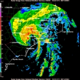
The storm caused flooding in seven counties within the state as a result of 5.05 inches (128.3 mm) of rainfall. Winds peaked at 85 miles per hour (136.8 km/h) which downed trees and power lines, and left 65,000 homes without power. A storm surge of 2 foot (0.6096 m) to 3 foot (0.9144 m) was reported, along with moderate waves that caused minor beach erosion. No deaths are attributed to the storm.
 On August 13, 2004, a tropical storm watch was issued for Cape Fear, southward to South Carolina
. The watch was extended northward to Oregon Inlet later that day; the watch further extended to Chincoteague, Virginia
. The tropical storm watch from Cape Lookout to Oregon Inlet was changed to a hurricane warning. A hurricane watch was subsequently put into effect for coastal areas from Oregon Inlet to the North Carolina/Virginia border, although by August 15 all advisories were discontinued. Flood watches were also placed into effect for portions of the state.
Governor Mike Easley
declared a state of emergency in advance of the storm, and 200 National Guard troops were dispatched to Charlotte
, Raleigh
, Kinston
and Lumerton
, while 800 more were on standby. On Ocracoke Island, authorities ordered mandatory evacuations, while on Bogue Banks
voluntary evacuations were in place. Officials in Wrightsville Beach
drove along the streets with loudspeakers mounted on trucks, warning tourists that a storm was approaching. The storm forced the University of North Carolina at Wilmington
to suspend a planned opening for students moving in to residence halls. Campgrounds at the Cape Hatteras National Seashore
were closed by the National Park Service
and three boat ramps were closed. Duke Power Co. prepared for Charley by lowering the level of hydroelectric lakes to make room for excessive rainfall. The state Department of Environment and Natural Resources advised hog farmers to pump out their waste lagoon. About 60 Red Cross shelters were opened during the storm and during the peak of Charley, and roughly 1,600 people sought protection.
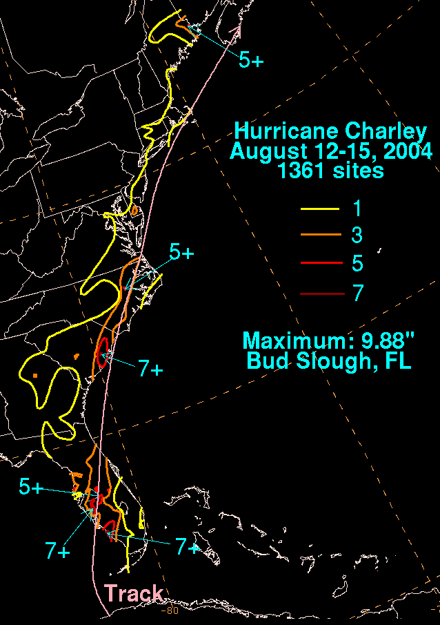 Hurricane Charley produced moderate to heavy rainfall over the state, peaking at 5.05 inches (128.3 mm) near Greenville; other rainfall amounts ranged from less than 1 inches (25.4 mm)–more than 4 inches (101.6 mm). The outer rainbands began affecting the region in the early hours of August 14. Due to widespread debris, storm drains became clogged which left flooding in some areas. Freshwater flooding was reported in seven counties along the coastal plain. State highways 42 and 581
, as well as numerous county and local roads, were convered with at least 1 foot (0.3048 m) of water. Wilmington and surrounding towns were forced to close a total of 20 streets. The heavy precipitation also caused the Neuse River
to swell to flood stage. A few businesses throughout the region were damaged; two in downtown Greenville and five others were flooded.
The storm produced estimated storm surge of 2 foot (0.6096 m) to 3 foot (0.9144 m), along with waves of up to 8 feet (2.4 m) in height. However, there were isolated reports of 8 feet (2.4 m) surge, particularly along the beaches of Brunswick County. This produced minor beach erosion along the coastline. Winds gusted from 60–70 miles per hour (95–110 km/h), causing minor wind damage. The hurricane spawned five weak tornadoes across the state, including an F1
in Nags Head
that damaged twenty structures. Charley destroyed 40 houses and damaged 2,231, 231 severely, including 221 damaged beach homes in Sunset Beach
. Damage was the greatest in Brunswick County
, where wind gusts peaked at 85 miles per hour (137 km/h). The winds blew down chimneys and damaged a roof on one building, and ripped the siding off another. Crop damage was also heavy in Brunswick County, with 50% of the tobacco crop lost and 30% of the corn and vegetable fields destroyed. Strong winds downed trees and power lines, leaving 65,000 homes without power. Damage in North Carolina totaled to $25 million (2004 USD).
Hurricane Charley
Hurricane Charley was the third named storm, the second hurricane, and the second major hurricane of the 2004 Atlantic hurricane season. Charley lasted from August 9 to August 15, and at its peak intensity it attained 150 mph winds, making it a strong Category 4 hurricane on the...
lasted from August 9 to August 15, 2004, and at peak intensity it attained 150 miles per hour (240 km/h) winds, making it a strong Category 4 hurricane on the Saffir-Simpson Hurricane Scale
Saffir-Simpson Hurricane Scale
The Saffir–Simpson Hurricane Scale , or the Saffir–Simpson Hurricane Wind Scale , classifies hurricanes — Western Hemisphere tropical cyclones that exceed the intensities of tropical depressions and tropical storms — into five categories distinguished by the intensities of their sustained winds...
. The storm made landfall
Landfall (meteorology)
Landfall is the event of a tropical cyclone or a waterspout coming onto land after being over water. When a waterspout makes landfall it is reclassified as a tornado, which can then cause damage inland...
in southwestern Florida
Florida
Florida is a state in the southeastern United States, located on the nation's Atlantic and Gulf coasts. It is bordered to the west by the Gulf of Mexico, to the north by Alabama and Georgia and to the east by the Atlantic Ocean. With a population of 18,801,310 as measured by the 2010 census, it...
at maximum strength, and moved northward, parallel to the U.S. East Coast before moving ashore on northeastern South Carolina.
The storm caused flooding in seven counties within the state as a result of 5.05 inches (128.3 mm) of rainfall. Winds peaked at 85 miles per hour (136.8 km/h) which downed trees and power lines, and left 65,000 homes without power. A storm surge of 2 foot (0.6096 m) to 3 foot (0.9144 m) was reported, along with moderate waves that caused minor beach erosion. No deaths are attributed to the storm.
Preparations
South Carolina
South Carolina is a state in the Deep South of the United States that borders Georgia to the south, North Carolina to the north, and the Atlantic Ocean to the east. Originally part of the Province of Carolina, the Province of South Carolina was one of the 13 colonies that declared independence...
. The watch was extended northward to Oregon Inlet later that day; the watch further extended to Chincoteague, Virginia
Chincoteague, Virginia
Chincoteague is a town on Chincoteague Island in Accomack County, Virginia, United States. The population was 4,317 at the 2000 census. The town is perhaps best known for the Chincoteague Ponies, although these are not actually on the island of Chincoteague but on nearby Assateague Island...
. The tropical storm watch from Cape Lookout to Oregon Inlet was changed to a hurricane warning. A hurricane watch was subsequently put into effect for coastal areas from Oregon Inlet to the North Carolina/Virginia border, although by August 15 all advisories were discontinued. Flood watches were also placed into effect for portions of the state.
Governor Mike Easley
Mike Easley
Michael Francis "Mike" Easley is an American politician who served as the 72nd Governor of the U.S. state of North Carolina, from 2001 to 2009. He is member of the North Carolina Democratic Party and became the first North Carolina governor to admit to a felony in a deal that halted a lengthy...
declared a state of emergency in advance of the storm, and 200 National Guard troops were dispatched to Charlotte
Charlotte, North Carolina
Charlotte is the largest city in the U.S. state of North Carolina and the seat of Mecklenburg County. In 2010, Charlotte's population according to the US Census Bureau was 731,424, making it the 17th largest city in the United States based on population. The Charlotte metropolitan area had a 2009...
, Raleigh
Raleigh, North Carolina
Raleigh is the capital and the second largest city in the state of North Carolina as well as the seat of Wake County. Raleigh is known as the "City of Oaks" for its many oak trees. According to the U.S. Census Bureau, the city's 2010 population was 403,892, over an area of , making Raleigh...
, Kinston
Kinston, North Carolina
Kinston is a city in Lenoir County, North Carolina, United States. The population was 23,688 at the 2000 census. The population was estimated at 22,360 in 2008. It has been the county seat of Lenoir County since its formation in 1791 . Kinston is located in North Carolina's Inner Banks...
and Lumerton
Lumberton, North Carolina
Lumberton is a city in Robeson County, North Carolina, United States. The population was 20,795 at the 2000 census. It is the county seat of Robeson County. Lumberton, located in southern North Carolina's Inner Banks region, is located on the Lumber River...
, while 800 more were on standby. On Ocracoke Island, authorities ordered mandatory evacuations, while on Bogue Banks
Bogue Banks
Bogue Banks form a barrier island off the mainland of North Carolina in Carteret County. The island, separated from the mainland by Bogue Sound, runs east to west, with the ocean beaches facing due south...
voluntary evacuations were in place. Officials in Wrightsville Beach
Wrightsville Beach, North Carolina
Wrightsville Beach is a town in New Hanover County, North Carolina, United States. Wrightsville Beach is just east of Wilmington and is part of the Wilmington Metropolitan Statistical Area. The population was 2,593 at the 2000 census...
drove along the streets with loudspeakers mounted on trucks, warning tourists that a storm was approaching. The storm forced the University of North Carolina at Wilmington
University of North Carolina at Wilmington
The University of North Carolina at Wilmington, sometimes referred to as UNC Wilmington, is a public, co-educational university located in Wilmington, North Carolina...
to suspend a planned opening for students moving in to residence halls. Campgrounds at the Cape Hatteras National Seashore
Cape Hatteras National Seashore
Cape Hatteras National Seashore preserves the portion of the Outer Banks of North Carolina from Bodie Island to Ocracoke Island, stretching over . Included within this section of barrier islands along N.C...
were closed by the National Park Service
National Park Service
The National Park Service is the U.S. federal agency that manages all national parks, many national monuments, and other conservation and historical properties with various title designations...
and three boat ramps were closed. Duke Power Co. prepared for Charley by lowering the level of hydroelectric lakes to make room for excessive rainfall. The state Department of Environment and Natural Resources advised hog farmers to pump out their waste lagoon. About 60 Red Cross shelters were opened during the storm and during the peak of Charley, and roughly 1,600 people sought protection.
Impact
North Carolina Highway 581
North Carolina Highway 581 is a highway running from NC 111 near Goldsboro to US 401 in Louisburg....
, as well as numerous county and local roads, were convered with at least 1 foot (0.3048 m) of water. Wilmington and surrounding towns were forced to close a total of 20 streets. The heavy precipitation also caused the Neuse River
Neuse River
The Neuse River is a river rising in the Piedmont of North Carolina and emptying into Pamlico Sound below New Bern. Its total length is approximately , making it the longest river entirely contained in North Carolina. The Trent River joins it at New Bern. Its drainage basin, measuring in area,...
to swell to flood stage. A few businesses throughout the region were damaged; two in downtown Greenville and five others were flooded.
The storm produced estimated storm surge of 2 foot (0.6096 m) to 3 foot (0.9144 m), along with waves of up to 8 feet (2.4 m) in height. However, there were isolated reports of 8 feet (2.4 m) surge, particularly along the beaches of Brunswick County. This produced minor beach erosion along the coastline. Winds gusted from 60–70 miles per hour (95–110 km/h), causing minor wind damage. The hurricane spawned five weak tornadoes across the state, including an F1
Fujita scale
The Fujita scale , or Fujita-Pearson scale, is a scale for rating tornado intensity, based primarily on the damage tornadoes inflict on human-built structures and vegetation...
in Nags Head
Nags Head, North Carolina
Nags Head is a town in Dare County, North Carolina, United States. The population was 2,700 at the 2000 census.-History:Early maps of the area show Nags Head as a promontory of land characterized by high sand dunes visible from miles at sea...
that damaged twenty structures. Charley destroyed 40 houses and damaged 2,231, 231 severely, including 221 damaged beach homes in Sunset Beach
Sunset Beach, North Carolina
Sunset Beach is a seaside town in Brunswick County, North Carolina, United States. The population was 1,824 at the 2000 census. It is part of the Wilmington Metropolitan Statistical Area.-Geography:Sunset Beach is located at ....
. Damage was the greatest in Brunswick County
Brunswick County, North Carolina
-External links:*******....
, where wind gusts peaked at 85 miles per hour (137 km/h). The winds blew down chimneys and damaged a roof on one building, and ripped the siding off another. Crop damage was also heavy in Brunswick County, with 50% of the tobacco crop lost and 30% of the corn and vegetable fields destroyed. Strong winds downed trees and power lines, leaving 65,000 homes without power. Damage in North Carolina totaled to $25 million (2004 USD).