
Ecclesall
Encyclopedia
Ecclesall Ward—which includes the neighbourhoods of Bents Green, Ecclesall, Greystones, Millhouses, and Ringinglow—is one of the 28 electoral wards in City of Sheffield
, England
. It is located in the southwestern part of the city and covers an area of 9.4 km2. The population of this ward in 2007 was 19,211 people in 7,626 households. Ecclesall ward is one of the four wards that make up the South West Community Assembly and one of five wards that make up the Sheffield Hallam Parliamentary constituency. The Member of Parliament is Nick Clegg
who is currently the leader of the Liberal Democrat Party and Deputy Prime Minister of the United Kingdom
. Ecclesall is one of the least socially deprived wards in the entire country, with a 2002 deprivation score of 4.7—making it the 8,105th most deprived (hence 309th least deprived) ward out of 8,414 wards in the country. The demographic consists largely of white, middle-class families.
The boundaries of the ward include about half of the area that was historically known as Ecclesall Bierlow—one of the six 'townships' that made up the old Parish of Sheffield. Ecclesall Bierlow encompassed most of the land between the River Sheaf
and the Porter Brook
from The Moor to Ringinglow. It also included the areas of Broomhall
and Crookesmoor to the north of Porter Brook. Though this area contained numerous small villages and hamlets, there was never a village called Ecclesall.
In ancient times this area was part of the Barnsdale Forest
that, together with Sherwood Forest
, made up the forest of the Robin Hood
legends. The River Sheaf marked the boundary between the Anglo-Saxon kingdoms of Mercia
and Deira (later Northumbria
). In fact the earliest historical record of this area refers to the submission of the Northumbrian army to Egbert of Wessex
at nearby Dore
in 829.
 The name Ecclesall (either from Heeksel-Hallr meaning the witches' hill, or Eccles (church) halh (hollow)) is not mentioned in the Domesday Book
of 1086—at that time Ecclesall was a part of the manor of Hallam
. The name is first found about 150 years later in the name of Sir Ralphus De Ecclesall a knight of the realm who had settled in the area. The De Ecclesall family gave land to the monks at Beauchief and established a corn
mill on the river Sheaf, which they subsequently also gave to Beauchief Abbey
. Many of the buildings of Ecclesall corn mill can still be seen at the northern end of Millhouses park—the district of Millhouses taking its name from this mill. In payment for the mill the monks of Beauchief were to provide a canon to say prayers daily at the Ecclesall chapel. These services continued at the chapel until the Dissolution of the Monasteries
when Beauchief Abbey was abandoned. The chapel was restored in 1622 but was demolished when the present church was built nearby in 1788.
Until the 19th century Ecclesall Bierlow was very sparsely populated—in 1801 there were just 5362 people. This changed with the coming of the industrial revolution
and the subsequent expansion of nearby Sheffield and by 1831 the population had increased to 14,239. In 1837 the Ecclesall Bierlow Poor Law Union came into being. As well as Ecclesall Bierlow, this encompassed Nether Hallam, Upper Hallam, Beauchief, Dore
, Norton, and Totley
. A workhouse was built on Cherry Tree Hill at Nether Edge
. In 1929 the Ecclesall Bierlow Workhouse was renamed Nether Edge Hospital and it remained in use as a hospital into the 1990s.
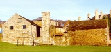
Historic sites within the ward include Abbeydale Industrial Hamlet
and Shepherd Wheel
(both now museums). Ecclesall Wood has many examples of white coal
kilns and the grave of a wood collier who was killed here when his cabin burned down on 11 October 1786.
at the intersection of Carter Knowle Road and Ecclesall Road
. The present church, dedicated to All Saints, was built in 1788, consecrated in 1789 and has been altered several times since. Banner Cross Hall, also in the area, was built in 1820.
valley to the north and west.
that grew around the Ecclesall Corn Mill.
) from central Sheffield to the south west, at first following the Porter Brook
, then running through Ecclesall and Dore
. The road is a major shopping area. Attractions including the Sheffield Botanical Gardens
and the Sheffield General Cemetery
lie alongside it, as does one of the campuses of Sheffield Hallam University
. Abbeydale Road South (A621) is another major road that runs through the ward. The Midland Main Line
railway line runs along the southern boundary of the ward, though the closest stations are outside of the ward at Sheffield (city centre) and Dore—the former Millhouses and Ecclesall station was closed on 10 June 1968. The Sheffield Supertram
currently has no routes through Ecclesall ward, but a planned extension to Dore would skirt the southern boundary.
, an area of ancient woodland (it has existed since at least the 16th century) that is known locally for being a bluebell wood
. In the north section of the ward is Bingham Park, Whiteley Woods and part of the Porter valley; Millhouses Park
marks the ward's southern boundary. The ward also includes some of Whirlow Brook Park and the Limb valley
. The Sheffield Round Walk
skirts the ward, running through a number of these parks.
and Silverdale School
. The ward also includes Ecclesall Junior School, Dobcroft Junior School, Greystones Primary School, Mylnhurst Convent School, and St Wilfrid's Primary School.
Sheffield
Sheffield is a city and metropolitan borough of South Yorkshire, England. Its name derives from the River Sheaf, which runs through the city. Historically a part of the West Riding of Yorkshire, and with some of its southern suburbs annexed from Derbyshire, the city has grown from its largely...
, England
England
England is a country that is part of the United Kingdom. It shares land borders with Scotland to the north and Wales to the west; the Irish Sea is to the north west, the Celtic Sea to the south west, with the North Sea to the east and the English Channel to the south separating it from continental...
. It is located in the southwestern part of the city and covers an area of 9.4 km2. The population of this ward in 2007 was 19,211 people in 7,626 households. Ecclesall ward is one of the four wards that make up the South West Community Assembly and one of five wards that make up the Sheffield Hallam Parliamentary constituency. The Member of Parliament is Nick Clegg
Nick Clegg
Nicholas William Peter "Nick" Clegg is a British Liberal Democrat politician who is currently the Deputy Prime Minister, Lord President of the Council and Minister for Constitutional and Political Reform in the coalition government of which David Cameron is the Prime Minister...
who is currently the leader of the Liberal Democrat Party and Deputy Prime Minister of the United Kingdom
Deputy Prime Minister of the United Kingdom
The Deputy Prime Minister of the United Kingdom of Great Britain and Northern Ireland is a senior member of the Cabinet of the United Kingdom. The office of the Deputy Prime Minister is not a permanent position, existing only at the discretion of the Prime Minister, who may appoint to other offices...
. Ecclesall is one of the least socially deprived wards in the entire country, with a 2002 deprivation score of 4.7—making it the 8,105th most deprived (hence 309th least deprived) ward out of 8,414 wards in the country. The demographic consists largely of white, middle-class families.
History
Ecclesall electoral ward was created 1934 when the old Ecclesall Bierlow ward was divided into Ecclesall, Broomhill and Hallam.The boundaries of the ward include about half of the area that was historically known as Ecclesall Bierlow—one of the six 'townships' that made up the old Parish of Sheffield. Ecclesall Bierlow encompassed most of the land between the River Sheaf
River Sheaf
The River Sheaf is a river in Sheffield, South Yorkshire, England. Its source is the union of the Totley Brook and the Old Hay Brook in Totley, now a suburb of Sheffield. It flows northwards, past Dore, through the valley called Abbeydale and north of Heeley...
and the Porter Brook
Porter Brook
The Porter Brook is a river in the City of Sheffield, Englanddescending over 300 metres from its source among the sedge grass on Burbage moor behind a small farm on Hangram just inside the Peak District National Park in the west of the city at Clough Hollow, near the village of Ringinglow...
from The Moor to Ringinglow. It also included the areas of Broomhall
Broomhall
Broomhall may refer to:* Broomhall, district in Sheffield, England* Broomhall Green, Crewe and Nantwich, Cheshire, EnglandPeople with the surname Broomhall:...
and Crookesmoor to the north of Porter Brook. Though this area contained numerous small villages and hamlets, there was never a village called Ecclesall.
In ancient times this area was part of the Barnsdale Forest
Barnsdale
Barnsdale, or Barnsdale Forest, is a relatively small area of South Yorkshire, England which has a rich history and the region is steeped in folklore. Historically part of the West Riding of Yorkshire...
that, together with Sherwood Forest
Sherwood Forest
Sherwood Forest is a Royal Forest in Nottinghamshire, England, that is famous through its historical association with the legend of Robin Hood. Continuously forested since the end of the Ice Age, Sherwood Forest National Nature Reserve today encompasses 423 hectares surrounding the village of...
, made up the forest of the Robin Hood
Robin Hood
Robin Hood was a heroic outlaw in English folklore. A highly skilled archer and swordsman, he is known for "robbing from the rich and giving to the poor", assisted by a group of fellow outlaws known as his "Merry Men". Traditionally, Robin Hood and his men are depicted wearing Lincoln green clothes....
legends. The River Sheaf marked the boundary between the Anglo-Saxon kingdoms of Mercia
Mercia
Mercia was one of the kingdoms of the Anglo-Saxon Heptarchy. It was centred on the valley of the River Trent and its tributaries in the region now known as the English Midlands...
and Deira (later Northumbria
Northumbria
Northumbria was a medieval kingdom of the Angles, in what is now Northern England and South-East Scotland, becoming subsequently an earldom in a united Anglo-Saxon kingdom of England. The name reflects the approximate southern limit to the kingdom's territory, the Humber Estuary.Northumbria was...
). In fact the earliest historical record of this area refers to the submission of the Northumbrian army to Egbert of Wessex
Egbert of Wessex
Egbert was King of Wessex from 802 until his death in 839. His father was Ealhmund of Kent...
at nearby Dore
Dore
Dore is a village in South Yorkshire, England. The village lies on a hill above the River Sheaf, and until 1934 was part of Derbyshire, but it is now a suburb of Sheffield. It is served by Dore and Totley railway station on the Hope Valley Line...
in 829.
Domesday Book
Domesday Book , now held at The National Archives, Kew, Richmond upon Thames in South West London, is the record of the great survey of much of England and parts of Wales completed in 1086...
of 1086—at that time Ecclesall was a part of the manor of Hallam
Hallam
-Places:* Hallamshire, an area in South Yorkshire, England; the source of the name for:** Hallam F.C. - a non-league football club in Sheffield.** Hallam FM, a radio station based in Sheffield.** Royal Hallamshire Hospital...
. The name is first found about 150 years later in the name of Sir Ralphus De Ecclesall a knight of the realm who had settled in the area. The De Ecclesall family gave land to the monks at Beauchief and established a corn
Cereal
Cereals are grasses cultivated for the edible components of their grain , composed of the endosperm, germ, and bran...
mill on the river Sheaf, which they subsequently also gave to Beauchief Abbey
Beauchief Abbey
Beauchief Abbey is a former abbey in Sheffield, England. Beauchief is prounounced bee-chiff.-History:The abbey was founded by Robert FitzRanulf de Alfreton. Thomas Tanner, writing in 1695, stated that it was founded in 1183...
. Many of the buildings of Ecclesall corn mill can still be seen at the northern end of Millhouses park—the district of Millhouses taking its name from this mill. In payment for the mill the monks of Beauchief were to provide a canon to say prayers daily at the Ecclesall chapel. These services continued at the chapel until the Dissolution of the Monasteries
Dissolution of the Monasteries
The Dissolution of the Monasteries, sometimes referred to as the Suppression of the Monasteries, was the set of administrative and legal processes between 1536 and 1541 by which Henry VIII disbanded monasteries, priories, convents and friaries in England, Wales and Ireland; appropriated their...
when Beauchief Abbey was abandoned. The chapel was restored in 1622 but was demolished when the present church was built nearby in 1788.
Until the 19th century Ecclesall Bierlow was very sparsely populated—in 1801 there were just 5362 people. This changed with the coming of the industrial revolution
Industrial Revolution
The Industrial Revolution was a period from the 18th to the 19th century where major changes in agriculture, manufacturing, mining, transportation, and technology had a profound effect on the social, economic and cultural conditions of the times...
and the subsequent expansion of nearby Sheffield and by 1831 the population had increased to 14,239. In 1837 the Ecclesall Bierlow Poor Law Union came into being. As well as Ecclesall Bierlow, this encompassed Nether Hallam, Upper Hallam, Beauchief, Dore
Dore
Dore is a village in South Yorkshire, England. The village lies on a hill above the River Sheaf, and until 1934 was part of Derbyshire, but it is now a suburb of Sheffield. It is served by Dore and Totley railway station on the Hope Valley Line...
, Norton, and Totley
Totley
Totley is a suburb on the extreme southwest of the City of Sheffield, in South Yorkshire, England. Lying in the historic county boundaries of Derbyshire, Totley was amalgamated into the city of Sheffield in 1935, and is today part of the Dore and Totley electoral ward in the city, though it remains...
. A workhouse was built on Cherry Tree Hill at Nether Edge
Nether Edge
Nether Edge Ward—which includes the districts of Brincliffe, Carter Knowle, Nether Edge, Sharrow Vale, and most of Banner Cross—is one of the 28 electoral wards in the City of Sheffield, England. It is located in the southern part of the city and covers an area of 3.4 km2...
. In 1929 the Ecclesall Bierlow Workhouse was renamed Nether Edge Hospital and it remained in use as a hospital into the 1990s.
Historic sites within the ward include Abbeydale Industrial Hamlet
Abbeydale Industrial Hamlet
Abbeydale Industrial Hamlet is an industrial museum in the south of the City of Sheffield, England. The museum forms part of a former steel-working site on the River Sheaf, with a history going back to at least the 13th century...
and Shepherd Wheel
Shepherd Wheel
Shepherd Wheel is a working museum in a former water-powered grinding workshop situated on the Porter Brook in the south-west of the City of Sheffield, England. One of the earliest wheels on the River Porter, it is one of the few remaining—and effectively complete—examples of this kind of...
(both now museums). Ecclesall Wood has many examples of white coal
White coal
White coal is a form of fuel produced by drying chopped wood over a fire. It differs from charcoal which is carbonised wood. White coal was used in England to smelt lead ore from the mid-sixteenth to the late seventeenth centuries. It produces more heat than green wood but less than charcoal and...
kilns and the grave of a wood collier who was killed here when his cabin burned down on 11 October 1786.
Ecclesall
The district of Ecclesall is centred roughly on Ecclesall parish churchAll Saints Church, Ecclesall
All Saints is a Church of England parish church in Sheffield, England. It is a Grade II listed building, and is located in Ecclesall, between Ringinglow Road and Ecclesall Road....
at the intersection of Carter Knowle Road and Ecclesall Road
Ecclesall Road
|thumb|200px|right|Ecclesall Road South, which runs through a large part of the Hallam Constituency, the second wealthiest in the UK.Ecclesall Road is a road in Sheffield that runs for about 3.5 miles south-west from Sheffield's city centre under the number A625...
. The present church, dedicated to All Saints, was built in 1788, consecrated in 1789 and has been altered several times since. Banner Cross Hall, also in the area, was built in 1820.
Greystones
Greystones lies to the north of the district of Ecclesall. It is on a headland overlooking the PorterPorter Brook
The Porter Brook is a river in the City of Sheffield, Englanddescending over 300 metres from its source among the sedge grass on Burbage moor behind a small farm on Hangram just inside the Peak District National Park in the west of the city at Clough Hollow, near the village of Ringinglow...
valley to the north and west.
Millhouses
Millhouses lies to the south of the district of Ecclesall. Its origins lie in a small hamletHamlet (place)
A hamlet is usually a rural settlement which is too small to be considered a village, though sometimes the word is used for a different sort of community. Historically, when a hamlet became large enough to justify building a church, it was then classified as a village...
that grew around the Ecclesall Corn Mill.
Bents Green
Bents Green lies to the west of the district of EcclesallRinginglow
Ringinglow is a village on the western border of Ecclesall Ward. Although it is within the boundary of the City of Sheffield, it is self-contained, entirely surrounded by open countryside. It is focussed on the intersections of Fulwood Lane and Houndkirk Road with Ringinglow Road.Transport
Ecclesall Road is the main road (A625A625 road
The A625 is a rural road which runs through north Derbyshire and the Peak District. First named Ecclesall Road, it begins at the Moore Street roundabout in Sheffield and runs southwesterly towards Hathersage after a change in name to Hathersage Road...
) from central Sheffield to the south west, at first following the Porter Brook
Porter Brook
The Porter Brook is a river in the City of Sheffield, Englanddescending over 300 metres from its source among the sedge grass on Burbage moor behind a small farm on Hangram just inside the Peak District National Park in the west of the city at Clough Hollow, near the village of Ringinglow...
, then running through Ecclesall and Dore
Dore
Dore is a village in South Yorkshire, England. The village lies on a hill above the River Sheaf, and until 1934 was part of Derbyshire, but it is now a suburb of Sheffield. It is served by Dore and Totley railway station on the Hope Valley Line...
. The road is a major shopping area. Attractions including the Sheffield Botanical Gardens
Sheffield Botanical Gardens
The Sheffield Botanical Gardens are botanical gardens situated off Ecclesall Road in Sheffield, England, with 5,000 species of plant in 19 acres of land....
and the Sheffield General Cemetery
Sheffield General Cemetery
The General Cemetery is a cemetery in the City of Sheffield, England that opened in 1836, and closed for burial in 1978. It was the principal cemetery in Victorian Sheffield with over 87,000 burials. Today it is a conservation area , and it is listed on the English Heritage National Register of...
lie alongside it, as does one of the campuses of Sheffield Hallam University
Sheffield Hallam University
Sheffield Hallam University is a higher education institution in South Yorkshire, England, based on two sites in Sheffield. City Campus is located in the city centre, close to Sheffield railway station, and Collegiate Crescent Campus is about two miles away, adjacent to Ecclesall Road in...
. Abbeydale Road South (A621) is another major road that runs through the ward. The Midland Main Line
Midland Main Line
The Midland Main Line is a major railway route in the United Kingdom, part of the British railway system.The present-day line links London St...
railway line runs along the southern boundary of the ward, though the closest stations are outside of the ward at Sheffield (city centre) and Dore—the former Millhouses and Ecclesall station was closed on 10 June 1968. The Sheffield Supertram
Sheffield Supertram
The Supertram, officially called the Stagecoach Supertram, is a light rail tram system in the City of Sheffield, South Yorkshire, England...
currently has no routes through Ecclesall ward, but a planned extension to Dore would skirt the southern boundary.
Parks and recreation
About half of Ecclesall ward is made up of rural areas, parkland, or woodland. These areas include a large portion of the 1.35 square kilometre Ecclesall WoodsEcclesall Woods
Ecclesall Woods is an area of woodland in south-west Sheffield, South Yorkshire, England, between Abbeydale Road South and Ecclesall. It covers approximately of mature semi-natural deciduous woodland which was previously used for timber and charcoal, and is currently managed by the city council...
, an area of ancient woodland (it has existed since at least the 16th century) that is known locally for being a bluebell wood
Bluebell wood
A bluebell wood is a woodland that in spring-time has a carpet of bluebells underneath a newly forming leaf canopy...
. In the north section of the ward is Bingham Park, Whiteley Woods and part of the Porter valley; Millhouses Park
Millhouses Park
Millhouses Park is a public urban park located in the Millhouses neighbourhood in south of Sheffield, England. It is a park stretching approximately along the floor of the valley of the River Sheaf, sandwiched between Abbeydale Road South and the railway tracks of the Midland Main Line.-Early...
marks the ward's southern boundary. The ward also includes some of Whirlow Brook Park and the Limb valley
Limb Brook
The Limb Brook is a stream in Sheffield, South Yorkshire, England. It rises at the village of Ringinglow, flowing east through Whirlow and Ecclesall Woods into Abbeydale in the Beauchief area, where it merges with the River Sheaf...
. The Sheffield Round Walk
Sheffield Round Walk
The Sheffield Round Walk is a 14 mile walk through the south west of Sheffield, South Yorkshire, England. Starting from Hunters Bar, it travels along the Porter valley to Ringinglow. It then descends through the Limb valley and Ecclesall Woods to Abbeydale Road, before climbing through Ladies...
skirts the ward, running through a number of these parks.
Education
There are two secondary schools within Ecclesall ward, High Storrs SchoolHigh Storrs School (Sheffield)
High Storrs is a secondary comprehensive school on the south-western outskirts of Sheffield in South Yorkshire, England.-Admissions:High Storrs has a Sixth Form and is a specialist Arts College in the Performing Arts, with a second specialism in Maths and Computing...
and Silverdale School
Silverdale School
Silverdale School is located in Sheffield, South Yorkshire, England. It opened in 1957 as a Secondary Modern School, then became a Comprehensive School in 1969. It serves approximately 1200 pupils from the local area, from ages eleven to eighteen. Silverdale achieves excellent results in national...
. The ward also includes Ecclesall Junior School, Dobcroft Junior School, Greystones Primary School, Mylnhurst Convent School, and St Wilfrid's Primary School.