
ESRI grid
Encyclopedia
An Esri grid is a raster
GIS file format
developed by Esri
, which has two formats:
The formats were introduced for ARC/INFO
. The binary format is widely used within Esri programs, such as ArcGIS
, while the ASCII format is used as an exchange, or export format, due to the simple and portable ASCII
file structure.
The grid defines geographic space as an array of equally sized square
grid points arranged in rows and columns. Each grid point stores a numeric value that represents a geographic attribute (such as elevation
or surface slope) for that unit of space. Each grid cell is referenced by its x,y coordinate location.
where
The remainder of the file lists the raster values for each cell, starting at the upper-left corner. These real number
s (with optional decimal point, if needed) and are delimited using a single space character
.
Raster graphics
In computer graphics, a raster graphics image, or bitmap, is a data structure representing a generally rectangular grid of pixels, or points of color, viewable via a monitor, paper, or other display medium...
GIS file format
GIS file formats
A GIS file format is a standard of encoding geographical information into a file. They are created mainly by government mapping agencies or by GIS software developers.Metadata often includes:...
developed by Esri
ESRI
Esri is a software development and services company providing Geographic Information System software and geodatabase management applications. The headquarters of Esri is in Redlands, California....
, which has two formats:
- A proprietaryProprietary softwareProprietary software is computer software licensed under exclusive legal right of the copyright holder. The licensee is given the right to use the software under certain conditions, while restricted from other uses, such as modification, further distribution, or reverse engineering.Complementary...
binaryBinary fileA binary file is a computer file which may contain any type of data, encoded in binary form for computer storage and processing purposes; for example, computer document files containing formatted text...
format, also known as an ARC/INFO GRID, ARC GRID and many other variations - A non-proprietary ASCIIASCIIThe American Standard Code for Information Interchange is a character-encoding scheme based on the ordering of the English alphabet. ASCII codes represent text in computers, communications equipment, and other devices that use text...
format, also known as an ARC/INFO ASCII GRID
The formats were introduced for ARC/INFO
ArcInfo
ArcInfo is a full-featured geographic information system produced by Esri, and is the highest level of licensing in the ArcGIS Desktop product line. It was originally a command-line based system...
. The binary format is widely used within Esri programs, such as ArcGIS
ArcGIS
ArcGIS is a suite consisting of a group of geographic information system software products produced by Esri.ArcGIS is a system for working with maps and geographic information...
, while the ASCII format is used as an exchange, or export format, due to the simple and portable ASCII
ASCII
The American Standard Code for Information Interchange is a character-encoding scheme based on the ordering of the English alphabet. ASCII codes represent text in computers, communications equipment, and other devices that use text...
file structure.
The grid defines geographic space as an array of equally sized square
Square (geometry)
In geometry, a square is a regular quadrilateral. This means that it has four equal sides and four equal angles...
grid points arranged in rows and columns. Each grid point stores a numeric value that represents a geographic attribute (such as elevation
Elevation
The elevation of a geographic location is its height above a fixed reference point, most commonly a reference geoid, a mathematical model of the Earth's sea level as an equipotential gravitational surface ....
or surface slope) for that unit of space. Each grid cell is referenced by its x,y coordinate location.
ASCII
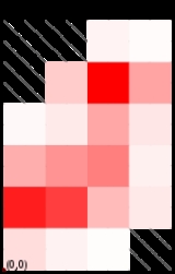
The format is relatively straightforward: the first six lines indicate the reference of the grid, followed by the values listed in the order they would naturally appear (left-right, top-down). For example, consider a grid, shown to the left. This could be encoded into an ASCII grid file, that would look like:| Grid image | Values | ASCII grid format | ||||
|---|---|---|---|---|---|---|
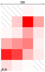 |
25 | 75 | 125 | 175 | ||
| 275 | NA | NA | 5 | 2 | ||
| 225 | NA | 20 | 100 | 36 | ||
| 175 | 3 | 8 | 35 | 10 | ||
| 125 | 32 | 42 | 50 | 6 | ||
| 75 | 88 | 75 | 27 | 9 | ||
| 25 | 13 | 5 | 1 | NA |
ncols         4

nrows         6

xllcorner     0.0

yllcorner     0.0

cellsize      50.0

NODATA_value  -9999

-9999 -9999 5 2

-9999 20 100 36

3 8 35 10

32 42 50 6

88 75 27 9

13 5 1 -9999
where
ncolsandnrowsare the numbers of rows and columns, respectively (represented as integerIntegerThe integers are formed by the natural numbers together with the negatives of the non-zero natural numbers .They are known as Positive and Negative Integers respectively...
s);xllcornerandyllcornerare the western (left) x-coordinate and southern (bottom) y-coordinates, such as easting and northingEasting and northingThe terms easting and northing are geographic Cartesian coordinates for a point. Easting refers to the eastward-measured distance , while northing refers to the northward-measured distance...
(represented as real numberReal numberIn mathematics, a real number is a value that represents a quantity along a continuum, such as -5 , 4/3 , 8.6 , √2 and π...
s with an optional decimal point)cellsizeis the lengthLengthIn geometric measurements, length most commonly refers to the longest dimension of an object.In certain contexts, the term "length" is reserved for a certain dimension of an object along which the length is measured. For example it is possible to cut a length of a wire which is shorter than wire...
of one side of a square cell (a real number); and,nodata_valueis the value that is regarded as "missing" or "not applicable"; this line is optional, but highly recommended as some programs expect this line to be declared (a real number).
The remainder of the file lists the raster values for each cell, starting at the upper-left corner. These real number
Real number
In mathematics, a real number is a value that represents a quantity along a continuum, such as -5 , 4/3 , 8.6 , √2 and π...
s (with optional decimal point, if needed) and are delimited using a single space character
Space (punctuation)
In writing, a space is a blank area devoid of content, serving to separate words, letters, numbers, and punctuation. Conventions for interword and intersentence spaces vary among languages, and in some cases the spacing rules are quite complex....
.