
Downtown Ottawa
Encyclopedia
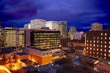
Downtown Ottawa is the central area of Ottawa
, Ontario
, Canada
. Like other downtowns it is the commercial and economic centre of the city. It is sometimes referred to as the Central Business District and contains Ottawa's financial district. It is bordered by the Ottawa River
to the north, the Rideau Canal
to the east, Gloucester Street to the south and Bronson Avenue
to the west. This area and the residential neighbourhood to the south are also known locally as 'Centretown'.
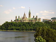 Downtown Ottawa is dominated by government buildings, including Parliament Hill
and the Supreme Court
. Most prominent buildings are situated along Wellington
, Sparks
and Elgin
streets. Most of the buildings are office towers containing the various government departments. While most of Ottawa's high tech
industry is based elsewhere it also has a significant presence in the downtown core. The downtown also contains a number of apartment
s, hotel
s, and condominium
s as well as the older single family homes and townhouses along its edges.
From Wellington to Laurier, Elgin Street is the site of several landmarks, the Chateau Laurier
, the National Arts Centre
, Lord Elgin Hotel
, Bell Canada Place
, the Ottawa Courthouse
, and Ottawa City Hall
. Other prominent buildings include World Exchange Plaza
with the 'clock ball' on top, Place de Ville
, and the heritage buildings along Sparks Street.
The towers of downtown Ottawa are not as tall as other those in other cities, as legislation prevented buildings being built taller than the Peace Tower
until the 1970s, so as not to overshadow the Parliament Buildings (similar to Washington, D.C.
's Heights of Buildings Act
). Today, several buildings are taller than the Peace Tower, with the tallest being the 29-storey Place de Ville
(Tower C) at 112 metres (367.5 ft), which was built above the height limit, and several hotels being slightly shorter but with 30-35 stories.
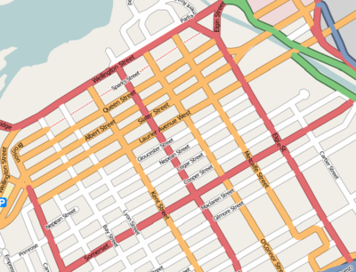 Downtown Ottawa has a grid
pattern of street
s, aligned either east-west or north-south with a number of the streets being one way.
, Metcalfe Street
, O'Connor Street
, Bank Street
, Kent Street
and Bronson Avenue.
Starting from the east:
, site of the parliamentary precinct, National Library and Archives, and Supreme Court. It is a major four-lane thoroughfare. To the east, it connects to Rideau Street, and to the west, the Ottawa River Parkway.
South of Wellington is Sparks Street
, most of which is a pedestrian mall closed to vehicles. The heritage district runs from Bank to Elgin, with CBC broadcast studios at Metcalfe and Sparks.
The streets to the south are dominated by office and hotel towers: Queen Street, Albert Street, Slater Street, Laurier Avenue and Gloucester Street. Albert and Slater also carry the transitway
through downtown.
The City of Ottawa zoning restricts and regulates development to allow high-rises north of Gloucester St. and affords heritage designation to some areas and buildings.
and the Byward Market
, is also normally considered downtown, and is referred to locally as 'Lowertown' or Lower Town
. The residential neighbourhoods around the central business district are also generally referred to as being downtown. These include Centretown
to the south and Sandy Hill
and Lower Town
to the east. North of the Ottawa River the centre of Gatineau
, Quebec
can be considered an extension of Ottawa's downtown.
. Area defined as the part of Ottawa north of Gloucester Street, east of Bronson, south of the Ottawa River and west of the Rideau Canal.
Politically, it is within the federal and provincial ridings of Ottawa Centre
.
, Sandy Hill
, and downtown Hull
. Click on the stars to read articles on individual buildings.
North-south (from west to east)
Ottawa
Ottawa is the capital of Canada, the second largest city in the Province of Ontario, and the fourth largest city in the country. The city is located on the south bank of the Ottawa River in the eastern portion of Southern Ontario...
, Ontario
Ontario
Ontario is a province of Canada, located in east-central Canada. It is Canada's most populous province and second largest in total area. It is home to the nation's most populous city, Toronto, and the nation's capital, Ottawa....
, Canada
Canada
Canada is a North American country consisting of ten provinces and three territories. Located in the northern part of the continent, it extends from the Atlantic Ocean in the east to the Pacific Ocean in the west, and northward into the Arctic Ocean...
. Like other downtowns it is the commercial and economic centre of the city. It is sometimes referred to as the Central Business District and contains Ottawa's financial district. It is bordered by the Ottawa River
Ottawa River
The Ottawa River is a river in the Canadian provinces of Ontario and Quebec. For most of its length, it now defines the border between these two provinces.-Geography:...
to the north, the Rideau Canal
Rideau Canal
The Rideau Canal , also known as the Rideau Waterway, connects the city of Ottawa, Ontario, Canada on the Ottawa River to the city of Kingston, Ontario on Lake Ontario. The canal was opened in 1832 as a precaution in case of war with the United States and is still in use today, with most of its...
to the east, Gloucester Street to the south and Bronson Avenue
Bronson Avenue (Ottawa)
Bronson Avenue is a major north-south arterial road in Ottawa, Ontario, Canada. It runs from downtown at Sparks Street in the north through Centretown, past the Glebe and Carleton University and turns into the Airport Parkway, which is an expressway to the Macdonald-Cartier International...
to the west. This area and the residential neighbourhood to the south are also known locally as 'Centretown'.
Prominent buildings
Parliament Hill
Parliament Hill , colloquially known as The Hill, is an area of Crown land on the southern banks of the Ottawa River in downtown Ottawa, Ontario. Its Gothic revival suite of buildingsthe parliament buildings serves as the home of the Parliament of Canada and contains a number of architectural...
and the Supreme Court
Supreme Court of Canada
The Supreme Court of Canada is the highest court of Canada and is the final court of appeals in the Canadian justice system. The court grants permission to between 40 and 75 litigants each year to appeal decisions rendered by provincial, territorial and federal appellate courts, and its decisions...
. Most prominent buildings are situated along Wellington
Wellington Street (Ottawa)
Wellington Street is an important street in Ottawa, Canada most notable for being one of the first two streets laid out in Bytown in 1826 Wellington Street (French: Rue Wellington) is an important street in Ottawa, Canada most notable for being one of the first two streets laid out in Bytown in...
, Sparks
Sparks Street
Sparks Street is a street in downtown Ottawa, Canada that was converted into an outdoor pedestrian street in 1966, making it the earliest such street or mall in North America....
and Elgin
Elgin Street (Ottawa)
Elgin Street is a street in the Golden Triangle of Ottawa, Ontario, Canada. Originally named Biddy's Lane, it was later named after Lord Elgin....
streets. Most of the buildings are office towers containing the various government departments. While most of Ottawa's high tech
High tech
High tech is technology that is at the cutting edge: the most advanced technology currently available. It is often used in reference to micro-electronics, rather than other technologies. The adjective form is hyphenated: high-tech or high-technology...
industry is based elsewhere it also has a significant presence in the downtown core. The downtown also contains a number of apartment
Apartment
An apartment or flat is a self-contained housing unit that occupies only part of a building...
s, hotel
Hotel
A hotel is an establishment that provides paid lodging on a short-term basis. The provision of basic accommodation, in times past, consisting only of a room with a bed, a cupboard, a small table and a washstand has largely been replaced by rooms with modern facilities, including en-suite bathrooms...
s, and condominium
Condominium
A condominium, or condo, is the form of housing tenure and other real property where a specified part of a piece of real estate is individually owned while use of and access to common facilities in the piece such as hallways, heating system, elevators, exterior areas is executed under legal rights...
s as well as the older single family homes and townhouses along its edges.
From Wellington to Laurier, Elgin Street is the site of several landmarks, the Chateau Laurier
Château Laurier
The Fairmont Château Laurier is a landmark hotel in Downtown Ottawa, Ontario located near the intersection of Rideau Street and Sussex Drive designed in the Châteauesque style.-History:...
, the National Arts Centre
National Arts Centre
The National Arts Centre is a centre for the performing arts located in Ottawa, Ontario, between Elgin Street and the Rideau Canal...
, Lord Elgin Hotel
Lord Elgin Hotel
The Lord Elgin Hotel is a prominent hotel in downtown Ottawa, Canada with 355 guest rooms, located at 100 Elgin Street at Laurier Avenue, across from Confederation Park...
, Bell Canada Place
Place Bell
Place Bell is one of the tallest buildings in Ottawa, Canada with a height of . The 27-storey building stands on Elgin Street in downtown Ottawa, and is distinguishable by its wide stature .The...
, the Ottawa Courthouse
Ottawa Courthouse
The Ottawa Courthouse is an Ontario provincial courthouse in Ottawa, Ontario. It is the main provincial court for the Ottawa area, and as such handles most of the region's legal affairs. The building is home to small claims, family, criminal, district, and the Ottawa branch of the Ontario Superior...
, and Ottawa City Hall
Ottawa City Hall
The current Ottawa City Hall is the city hall of Ottawa, Canada. The downtown complex consists of two connected buildings: a modern wing located on Laurier Avenue and a 19th century heritage wing located on Elgin Street...
. Other prominent buildings include World Exchange Plaza
World Exchange Plaza
The World Exchange Plaza is a building in downtown Ottawa, Ontario, Canada. The first phase of the project was completed in 1991. It covers an entire city block between Metcalfe and O'Connor south of Queen Street. The twenty-storey building was unusual in Ottawa for its visual flair. The eastern...
with the 'clock ball' on top, Place de Ville
Place de Ville
Place de Ville is a complex of office towers in downtown Ottawa. It currently consists of four buildings, Place de Ville A, B, and C, and the 'Podium' building, two large hotels, and the city's largest underground parking garage. The buildings are linked by an underground shopping complex...
, and the heritage buildings along Sparks Street.
The towers of downtown Ottawa are not as tall as other those in other cities, as legislation prevented buildings being built taller than the Peace Tower
Peace Tower
The Peace Tower is a focal bell and clock tower, sitting on the central axis of the Centre Block of the Canadian parliament buildings in Ottawa, Ontario. The present incarnation replaced the Victoria Tower after the latter burned down in 1916, along with most of the Centre Block...
until the 1970s, so as not to overshadow the Parliament Buildings (similar to Washington, D.C.
Washington, D.C.
Washington, D.C., formally the District of Columbia and commonly referred to as Washington, "the District", or simply D.C., is the capital of the United States. On July 16, 1790, the United States Congress approved the creation of a permanent national capital as permitted by the U.S. Constitution....
's Heights of Buildings Act
Heights of Buildings Act of 1910
The Heights of Buildings Act of 1910 was an Act of Congress passed by the 61st United States Congress on June 1, 1910 to limit the height of buildings in Washington, D.C. The original act was passed in 1899 when the 55th United States Congress passed the Heights of Buildings Act of 1899...
). Today, several buildings are taller than the Peace Tower, with the tallest being the 29-storey Place de Ville
Place de Ville
Place de Ville is a complex of office towers in downtown Ottawa. It currently consists of four buildings, Place de Ville A, B, and C, and the 'Podium' building, two large hotels, and the city's largest underground parking garage. The buildings are linked by an underground shopping complex...
(Tower C) at 112 metres (367.5 ft), which was built above the height limit, and several hotels being slightly shorter but with 30-35 stories.
Prominent streets
Grid (spatial index)
In the context of a spatial index, a grid is a regular tessellation of a manifold or 2-D surface that divides it into a series of contiguous cells, which can then be assigned unique identifiers and used for spatial indexing purposes...
pattern of street
Street
A street is a paved public thoroughfare in a built environment. It is a public parcel of land adjoining buildings in an urban context, on which people may freely assemble, interact, and move about. A street can be as simple as a level patch of dirt, but is more often paved with a hard, durable...
s, aligned either east-west or north-south with a number of the streets being one way.
North-South streets
From east to west, the prominent streets are Elgin StreetElgin Street (Ottawa)
Elgin Street is a street in the Golden Triangle of Ottawa, Ontario, Canada. Originally named Biddy's Lane, it was later named after Lord Elgin....
, Metcalfe Street
Metcalfe Street
Metcalfe Street is a downtown arterial road in Ottawa, Canada. It is named for Charles Theophilus Metcalfe, a nineteenth century Governor General of the Province of Canada. It is a north-south route, operating one way northbound, providing a key thoroughfare from Highway 417...
, O'Connor Street
O'Connor Street
O'Connor Street is a downtown arterial road in Ottawa, Canada. It is a north-south route, operating one way southbound, providing a key thoroughfare parallel to Bank Street....
, Bank Street
Bank Street (Ottawa)
Bank Street is the major north-south road in Ottawa, Ontario, Canada. It runs south from Wellington Street in downtown Ottawa, south through the neighbourhoods of Centretown, The Glebe, Old Ottawa South, Alta Vista, Hunt Club, and then through the villages of Blossom Park, Leitrim, South...
, Kent Street
Kent Street (Ottawa)
Kent Street is a major street in downtown Ottawa, Canada. One block west of Bank Street, Kent is one way running north. It begins at the Queensway at the south and ends at Wellington Street. The street has fewer storefronts than Bank Street. South of downtown it is mainly small and medium sized...
and Bronson Avenue.
Starting from the east:
- Elgin StreetElgin Street (Ottawa)Elgin Street is a street in the Golden Triangle of Ottawa, Ontario, Canada. Originally named Biddy's Lane, it was later named after Lord Elgin....
, a ceremonial route for the daily Changing of the Guard and site of many prominent buildings and landmarks, and a restaurant district south of Laurier Avenue, - Metcalfe and O'Connor, both of which are busy multi-lane one way streets,
- Bank StreetBank Street (Ottawa)Bank Street is the major north-south road in Ottawa, Ontario, Canada. It runs south from Wellington Street in downtown Ottawa, south through the neighbourhoods of Centretown, The Glebe, Old Ottawa South, Alta Vista, Hunt Club, and then through the villages of Blossom Park, Leitrim, South...
runs through the heart of downtown and is a prominent retail centre, - Kent StreetKent Street (Ottawa)Kent Street is a major street in downtown Ottawa, Canada. One block west of Bank Street, Kent is one way running north. It begins at the Queensway at the south and ends at Wellington Street. The street has fewer storefronts than Bank Street. South of downtown it is mainly small and medium sized...
, another busy multi-lane one way with high traffic volumes, - Lyon, Bay and Percy, are one way local residential streets, and,
- Bronson Avenue is a major avenue that forms the western edge of downtown.
East-West streets
The northernmost east-west street that crosses downtown is Wellington StreetWellington Street (Ottawa)
Wellington Street is an important street in Ottawa, Canada most notable for being one of the first two streets laid out in Bytown in 1826 Wellington Street (French: Rue Wellington) is an important street in Ottawa, Canada most notable for being one of the first two streets laid out in Bytown in...
, site of the parliamentary precinct, National Library and Archives, and Supreme Court. It is a major four-lane thoroughfare. To the east, it connects to Rideau Street, and to the west, the Ottawa River Parkway.
South of Wellington is Sparks Street
Sparks Street
Sparks Street is a street in downtown Ottawa, Canada that was converted into an outdoor pedestrian street in 1966, making it the earliest such street or mall in North America....
, most of which is a pedestrian mall closed to vehicles. The heritage district runs from Bank to Elgin, with CBC broadcast studios at Metcalfe and Sparks.
The streets to the south are dominated by office and hotel towers: Queen Street, Albert Street, Slater Street, Laurier Avenue and Gloucester Street. Albert and Slater also carry the transitway
Ottawa Rapid Transit
In Ottawa, Ontario, Canada, the public transit service operated by OC Transpo has two rapid transit systems: the Transitway, a bus rapid transit network, and the O-Train, a diesel-powered light rail transit service operated on one line.-Major routes:...
through downtown.
The City of Ottawa zoning restricts and regulates development to allow high-rises north of Gloucester St. and affords heritage designation to some areas and buildings.
Surrounding areas
East of the canal, but west of King Edward Avenue, including the Rideau CentreRideau Centre
Rideau Centre is a three-level shopping centre on Rideau Street in Downtown Ottawa, Ontario, Canada. It borders on Rideau Street , the Rideau Canal, the Mackenzie King Bridge, and Nicholas Street....
and the Byward Market
Byward Market
ByWard Market is a district in Lower Town located east of the government & business district, surrounding the market buildings and open-air market on George, York, ByWard and William Streets.The district is bordered on the west by Sussex Drive, on the...
, is also normally considered downtown, and is referred to locally as 'Lowertown' or Lower Town
Lower Town
Lowertown is a district in the central area of Ottawa, Ontario, Canada to the east of downtown. It is bounded roughly by Rideau Street to the south, Sussex Drive and Ottawa River to the north, the Rideau Canal to the west, and the Rideau River to the east...
. The residential neighbourhoods around the central business district are also generally referred to as being downtown. These include Centretown
Centretown
Centretown is a neighbourhood in Ottawa, Canada defined by the city as "the area bounded on the north by Gloucester Street and Lisgar Street, on the east by the Rideau Canal, on the south by the Queensway Freeway and on the west by Bronson Avenue." Traditionally it was all of Ottawa west of the...
to the south and Sandy Hill
Sandy Hill
Sandy Hill is a bilingual neighbourhood in Ottawa, Ontario located just east of downtown. The neighbourhood is bordered on the west by the Rideau Canal and on the east by the Rideau River. To the north it stretches to Rideau Street and the Byward Market area while to the south it is bordered by...
and Lower Town
Lower Town
Lowertown is a district in the central area of Ottawa, Ontario, Canada to the east of downtown. It is bounded roughly by Rideau Street to the south, Sussex Drive and Ottawa River to the north, the Rideau Canal to the west, and the Rideau River to the east...
to the east. North of the Ottawa River the centre of Gatineau
Gatineau
Gatineau is a city in western Quebec, Canada. It is the fourth largest city in the province. It is located on the northern banks of the Ottawa River, immediately across from Ottawa, Ontario, and together they form Canada's National Capital Region. Ottawa and Gatineau comprise a single Census...
, Quebec
Quebec
Quebec or is a province in east-central Canada. It is the only Canadian province with a predominantly French-speaking population and the only one whose sole official language is French at the provincial level....
can be considered an extension of Ottawa's downtown.
Demographics
According to the Canada 2006 CensusCanada 2006 Census
The Canada 2006 Census was a detailed enumeration of the Canadian population. Census day was May 16, 2006. The next census following will be the 2011 Census. Canada's total population enumerated by the 2006 census was 31,612,897...
. Area defined as the part of Ottawa north of Gloucester Street, east of Bronson, south of the Ottawa River and west of the Rideau Canal.
- Population: 3,718
- Change (2001-2006): +2.7%
- Total private dwellings: 2,875
- Land area: 1.25 km².
- Population density: 2,977.5 per km².
Politically, it is within the federal and provincial ridings of Ottawa Centre
Ottawa Centre
Ottawa Centre is an urban federal electoral district in Ontario, Canada, that has been represented in the Canadian House of Commons since 1968...
.
Map
A map of downtown Ottawa, also including parts of Lower TownLower Town
Lowertown is a district in the central area of Ottawa, Ontario, Canada to the east of downtown. It is bounded roughly by Rideau Street to the south, Sussex Drive and Ottawa River to the north, the Rideau Canal to the west, and the Rideau River to the east...
, Sandy Hill
Sandy Hill
Sandy Hill is a bilingual neighbourhood in Ottawa, Ontario located just east of downtown. The neighbourhood is bordered on the west by the Rideau Canal and on the east by the Rideau River. To the north it stretches to Rideau Street and the Byward Market area while to the south it is bordered by...
, and downtown Hull
Hull, Quebec
Hull is the central and oldest part of the city of Gatineau, Quebec, Canada. It is located on the west bank of the Gatineau River and the north shore of the Ottawa River, directly opposite Ottawa. As part of the Canadian National Capital Region, it contains offices for twenty thousand...
. Click on the stars to read articles on individual buildings.
Transitway stations
- Metcalfe Transitway Station
- Bank Transitway Station
- Kent Transitway Station
- Bay Transitway Station
Downtown churches
- City View International Church
- First Baptist ChurchFirst Baptist Church (Ottawa)First Baptist Church is a prominent Baptist church in downtown Ottawa, Canada. It is part of the Baptist Convention of Ontario and Quebec. It was designed by James Mather.The church was first founded in 1857, the first Baptist congregation in Ottawa...
- Christ Church CathedralChrist Church Cathedral (Ottawa)Christ Church Cathedral is the Anglican cathedral in Ottawa, Ontario, Canada. The church is located in the northwest section of the city's downtown at the western end of Sparks Street at the top of a promontory looking down to the Ottawa River.-Beginnings:...
- Church of St. John the EvangelistAnglican Church of St. John the Evangelist (Ottawa)The Church of St. John the Evangelist is an Anglican church found in the heart of Ottawa, Ontario, Canada, at the corner of Elgin and Somerset Streets...
- Dominion-Chalmers United ChurchDominion-Chalmers United ChurchDominion Chalmers United Church is a large United church, located in downtown Ottawa, at the corner of Cooper and O'Connor Streets...
- Knox Presbyterian ChurchKnox Presbyterian Church (Ottawa)Knox Presbyterian Church is a Presbyterian Church in Ottawa, Ontario, Canada. It is named after John Knox, a founder of Presbyterianism in Scotland.It was founded as a result of the split within the congregation of St...
- St. Andrew's Presbyterian ChurchSt. Andrew's Presbyterian Church (Ottawa)St. Andrew's Presbyterian Church is the oldest Presbyterian church in Ottawa, Canada.-Creation:St. Andrews is Ottawa's oldest Protestant [Presbyterian Church in Canada] congregation, with the original church opening in 1828...
- St. Patrick's Basilica
- St. Peter's Lutheran ChurchSt. Peter's Lutheran Church, OttawaSt. Peter's Lutheran Church in Ottawa, Ontario was established in 1910 with 66 members. The first building was erected on Lyon Street and dedicated on Easter Sunday in 1914...
- St. Theresa's Catholic ChurchSt. Theresa's Catholic Church (Ottawa)St. Theresa's Catholic Church is a Roman Catholic church in downtown Ottawa, Canada. The church is located in the eastern section of downtown, on Somerset Street between Elgin Street and the Rideau Canal. The parish was founded in 1929, split off from St. Patrick's parish that had covered all of...
Grid streets
East-west (from north to south)- Wellington StreetWellington Street (Ottawa)Wellington Street is an important street in Ottawa, Canada most notable for being one of the first two streets laid out in Bytown in 1826 Wellington Street (French: Rue Wellington) is an important street in Ottawa, Canada most notable for being one of the first two streets laid out in Bytown in...
- Sparks StreetSparks StreetSparks Street is a street in downtown Ottawa, Canada that was converted into an outdoor pedestrian street in 1966, making it the earliest such street or mall in North America....
- Queen Street
- Albert StreetAlbert Street (Ottawa)Albert Street is one of the main east-west roads in downtown Ottawa, Canada. Albert is one way going west. It carries the westbound portion of the transitway through downtown, with Slater Street just to the south carrying the eastbound portion...
- Slater Street
- Laurier Avenue
- Gloucester Street
North-south (from west to east)
- Bronson AvenueBronson Avenue (Ottawa)Bronson Avenue is a major north-south arterial road in Ottawa, Ontario, Canada. It runs from downtown at Sparks Street in the north through Centretown, past the Glebe and Carleton University and turns into the Airport Parkway, which is an expressway to the Macdonald-Cartier International...
- Percy Street (runs north until Laurier)
- Bay Street
- Lyon Street
- Kent StreetKent Street (Ottawa)Kent Street is a major street in downtown Ottawa, Canada. One block west of Bank Street, Kent is one way running north. It begins at the Queensway at the south and ends at Wellington Street. The street has fewer storefronts than Bank Street. South of downtown it is mainly small and medium sized...
- Bank StreetBank Street (Ottawa)Bank Street is the major north-south road in Ottawa, Ontario, Canada. It runs south from Wellington Street in downtown Ottawa, south through the neighbourhoods of Centretown, The Glebe, Old Ottawa South, Alta Vista, Hunt Club, and then through the villages of Blossom Park, Leitrim, South...
- O'Connor Street
- Metcalfe Street
- Elgin StreetElgin Street (Ottawa)Elgin Street is a street in the Golden Triangle of Ottawa, Ontario, Canada. Originally named Biddy's Lane, it was later named after Lord Elgin....