

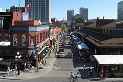
Byward Market
Encyclopedia
Lower Town
Lowertown is a district in the central area of Ottawa, Ontario, Canada to the east of downtown. It is bounded roughly by Rideau Street to the south, Sussex Drive and Ottawa River to the north, the Rideau Canal to the west, and the Rideau River to the east...
(Ottawa
Ottawa
Ottawa is the capital of Canada, the second largest city in the Province of Ontario, and the fourth largest city in the country. The city is located on the south bank of the Ottawa River in the eastern portion of Southern Ontario...
, Ontario
Ontario
Ontario is a province of Canada, located in east-central Canada. It is Canada's most populous province and second largest in total area. It is home to the nation's most populous city, Toronto, and the nation's capital, Ottawa....
) located east of the government & business district, surrounding the market buildings and open-air market on George, York, ByWard and William Streets.
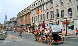
The district is bordered on the west by Sussex Drive
Sussex Drive
Sussex Drive is a major street in Ottawa, Ontario, Canada, and one of the city's major ceremonial and institutional routes....
, on the east by Cumberland Street. It stretches northwards to Cathcart Street, while to the south it is bordered by Rideau Street
Rideau Street
Rideau Street is a major street in downtown Ottawa, Ontario, Canada and one of Ottawa's oldest and most famous streets running from Wellington Street in the west to Montreal Road in the east where it connects to the Vanier district...
. The name refers to the old 'By Ward
By Ward
By Ward was one of the five original wards represented on Ottawa City Council. Originally it represented the area between Rideau Street and St. Patrick Street. Today this area is part of the By Ward Market, which is named for the historic ward...
' of the City of Ottawa ('By' deriving from the surname of the engineer, Colonel John By
John By
Lieutenant-Colonel John By was a British military engineer, best remembered for supervising the construction of the Rideau Canal and, in the process, founding what would become the city of Ottawa....
, who was the area's original surveyor). The district comprises the main commercial part of the historic Lower Town
Lower Town
Lowertown is a district in the central area of Ottawa, Ontario, Canada to the east of downtown. It is bounded roughly by Rideau Street to the south, Sussex Drive and Ottawa River to the north, the Rideau Canal to the west, and the Rideau River to the east...
area of Ottawa.
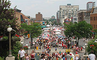
The market itself is Canada's oldest continuously operating farmers' market, regulated by the City of Ottawa's Markets Management group, which also operates the smaller west-end Parkdale Market. The market building is open year-round, and open-air stalls are operated in the warmer months offering fresh produce and flowers.
Neighbourhood
National Gallery of Canada
The National Gallery of Canada , located in the capital city Ottawa, Ontario, is one of Canada's premier art galleries.The Gallery is now housed in a glass and granite building on Sussex Drive with a notable view of the Canadian Parliament buildings on Parliament Hill. The acclaimed structure was...
, which was built across Sussex Drive.
The ByWard Market has constantly been an area of fluid change, adapting to the increasingly cosmopolitan nature of downtown Ottawa, as well as trends in Canadian society as a whole. Recently, a multitude of restaurants and specialty food stores have sprouted around the market area, making this neighbourhood one of the liveliest in Ottawa outside of normal business hours. A four block area around the market provides the most dense concentration of eating places, bars and nightclubs in the National Capital Region. The areas beyond this zone also offer boutiques and restaurants in abundance, and are frequented by a considerable number of buskers
Busking
Street performance or busking is the practice of performing in public places, for gratuities, which are generally in the form of money and edibles...
(street performers). Having acquired a reputation as the city's premier bar district, Byward Market is thronged at night with university students and other young adults.
Embassy of the United States in Ottawa
The United States Embassy in Ottawa is a building located in Ottawa which opened in 1999.-Original mission:Before this date the mission occupied a 1930s era building directly across from Parliament Hill at 100 Wellington Street...
. The building's design, by noted architect David Childs, was somewhat controversial in Ottawa. Others complained that the structure overshadowed the historic market.
The neighbourhood is today markedly heterogeneous, being visited by a mix of yuppie
Yuppie
Yuppie is a term that refers to a member of the upper middle class or upper class in their 20s or 30s. It first came into use in the early-1980s and largely faded from American popular culture in the late-1980s, due to the 1987 stock market crash and the early 1990s recession...
couples, many families and some homeless people. At one time, the area had a serious prostitution problem, which was remedied by a controversial rerouting of traffic through much of the residential area. The area is mainly English
English language
English is a West Germanic language that arose in the Anglo-Saxon kingdoms of England and spread into what was to become south-east Scotland under the influence of the Anglian medieval kingdom of Northumbria...
-speaking but there exists a significant francophone
Francophone
The adjective francophone means French-speaking, typically as primary language, whether referring to individuals, groups, or places. Often, the word is used as a noun to describe a natively French-speaking person....
population as well. The Market is located in close proximity to the downtown, to the Rideau Centre
Rideau Centre
Rideau Centre is a three-level shopping centre on Rideau Street in Downtown Ottawa, Ontario, Canada. It borders on Rideau Street , the Rideau Canal, the Mackenzie King Bridge, and Nicholas Street....
shopping mall, to Parliament Hill
Parliament Hill
Parliament Hill , colloquially known as The Hill, is an area of Crown land on the southern banks of the Ottawa River in downtown Ottawa, Ontario. Its Gothic revival suite of buildingsthe parliament buildings serves as the home of the Parliament of Canada and contains a number of architectural...
and to a number of foreign embassies.
History and evolution of the ByWard Market
In 1826, Lieutenant Colonel John By of the Royal Engineers was sent from England to oversee the construction of the Rideau canal system, which was designed to connect the Ottawa River to Kingston, on the St. Lawrence River. It was out of this massive project that the small community of Bytown grew into a flourishing commercial and economic centre. Colonel By prepared plans for two village sites: one on the west side of the Rideau canal, which was known as Upper Town; and one to the east of the canal, called Lower Town.The land was cleared and surveyed. Both villages were laid out in a grid system and divided into building lots. The Village of Lower Town was originally bounded by the Rideau River and Sussex, Clarence, and Rideau Streets. This town plan also included an area designated as a commercial section within the block bounded by George, Sussex, York and King Streets. Lt.-Col By designed George and York Streets 132 feet (40.2 m) wide in order to leave room for a proposed market building and courthouse, and also to leave room for the flow of the By Wash.
Most of the Lower Town site was covered with swampland, which had to be drained. Excess water from the canal was released through a sluice gate. This became known as the By Wash, which ran through Lower Town and emptied into the Rideau River.
From the beginning Bytown was divided, not only physically by the canal but racially, politically and economically. Upper Town was settled by officers, tradesmen and professionals, most of whom were Protestants and Anglicans of English or Scottish descent. On the other hand, Lower Town was settled by labourers who had come to Bytown seeking employment during the building of the canal. These inhabitants were mainly Catholic Irish immigrants and French Canadians. In 1827, the two towns were connected along Rideau Street by Sappers Bridge, which spanned the canal.
First Market
Also, in 1827, Colonel By used 160 pounds of revenue from property rents to build a market building with a courthouse behind it on George Street. This was the original market building, large for the time, and constructed of timber with dovetailed corners, a veranda on each side, and an attached weighing machine. This building served both as a centre for market activities, and as a public hall for political and religious meetings.In the 1830s, Lower Town enjoyed a period of rapid commercial growth. Stores of every description, hotels, taverns and industrial buildings sprang up all around the market area. The first sawmill in Bytown was erected on York Street and was driven by the waters of the By Wash. Soon Lower Town became commercially dominant.
The market on George Street quickly began to do a flourishing business providing lumber camps with supplies. Farm communities shipped goods up the Ottawa River or along the Rideau waterway to merchants in the Lower Town Market. A large butchering and meatpacking industry developed on the south side of George Street across from the market. This became known as the “Butcher’s Shambles”. Around 1840, a public well was opened in the market square. Lower Town had become an established commercial and residential centre.
In 1842 the market building and the courthouse in the centre of George Street were dismantled. However, the market area continued to operate in a haphazard way around the remains of the old market building. The mixed farming of the surrounding region was dependent on Bytown for the distribution of its agricultural goods, and the local community required a market to sustain its growth. When Bytown was incorporated as a town on July 28, 1847, the new city council recognized the need for an organized market area, and made this one of their first priorities.
Second Market
The debate for the site of the market began almost as soon as the first council was elected. Lower Town had the political advantage, since it was entitled to four councillors out of seven elected. Lower Town enjoyed several other advantages over Upper Town for the site of a market building. Lower Town was linked with the outlying farming areas that extended from Gloucester Township to Russell and Prescott Counties. Lower Town was already an established commercial centre for goods and its citizens wanted to keep the major services there to prevent a population and economic shift to Upper Town.After extensive discussion, a motion was passed that two markets should be built, one for each town. In Upper Town, Nicholas Sparks offered a piece of his land near Sappers Bridge for the West Ward Market. In Lower Town Mrs. James Inglis donated her property between Clarence and York Streets, which comprised four lots measuring 196 feet (59.7 m) deep by 132 feet (40.2 m) wide.
The two sites were approved by council on June 26, 1848. In order to oversee the construction of the two markets a Market Committee was set up. Charles Sparrow, a councillor for Lower Town, became the Chairman of the Committee.
The Lower Town Market Building officially opened on Saturday, November 6, 1848. The ceremony was marked by a flag raising, several speeches, and a band which played "Rule Britannia". This new market building was constructed of wood with room for market stalls on the ground floor and a well-lit upper floor to be used for public meetings. The Upper Town market was converted into a town hall and remained this way until 1878, when it was demolished to make way for a new city hall.
In September 1849, the market area was the scene of the "Stony Monday Riot". The conflict was sparked by the political and religious disputes between Catholic Reformers (in Lower Town) and Protestant Tories (in Upper Town). The controversy came to a head during a non-political reception for the visiting Lord Elgin. During the meeting in the Lower Town market building on September 17, the crowd became agitated. Reformers and Conservatives separated into two groups and a stone-throwing fracas began which lasted about 15 minutes. The group of Conservatives drove the Reformers off of the market square, west along York Street and up Clarence Street where they took refuge behind the fence of L'Esperance's Hotel. Soon after a gun battle began in the market square between the two parties. When the riot was over one man was killed, 30 were wounded and 15 men (all Reformers) were arrested.
The Lower Town market continued successfully into the 1850s. Due to overcrowding, it was decided that the market should be expanded. In 1853, four adjoining lots on York and Clarence Streets were purchased for the expansion plan. A bell was purchased and installed by the council in order to regulate the market hours.
Third Market
While the expansion study was underway, the market building was destroyed by fire on January 21, 1862. During the 1860s and early 1870s several other fires hindered the growth of the market area. Fortunately, throughout this time the market continued to function, and the council persevered in its efforts to erect a new market building. In 1864, construction of a new building, designed by architect Sydney B. Fripp, began between Clarence and York Streets. This market building was open in 1865. Although it offered better indoor facilities for vendors, it did not improve the overcrowding outside of the building.From 1840 to 1870, the economic base of Ottawa changed drastically, on account of the removal of the British military, the end of the continental fur trade, and the expansion of the lumber industry. With the opening of the canal and the incorporation of the city in 1855, Ottawa was forced to expand its role as a regional trading centre in agricultural products and services. All of this agricultural and commercial activity was directed through the Byward market area. As a result, the market area was expanded and York, ByWard and William Streets became a hub of commerce. Many industries converged in this area: bakeries, bottling works, a soap and candle factory, a broom manufacturer, as well as carriage and furniture manufacturers. Other businesses operating in the marketplace included retail outlets for agricultural machinery, flour and feed traders, grocery provisioners, hardware suppliers and merchants engaged in similar import/export enterprises.
Many service industries also developed, notably saddlers, tailors, carpenters, hostlers, metal and tin workers. In addition butchers, fishmongers, and fresh fruit and vegetable merchants lined the streets facing the market building. (Of these, the Lapointe Fish Market, established in 1867, still operates in the market.)
The market building itself was divided into sections for farmers, gardeners, slaughterers, florists, hucksters, livestock dealers, etc. These sections were subdivided into stalls, which were leased annually by the vendors. The vendors were also charged a fee for keeping the market clean. A Market Inspector was appointed to oversee the market area and the public weigh scales. Additionally, a meat inspector had an office in the market building.
During this time most merchants resided above their stores, or contained their businesses in sheds to the side or rear of their home. Hotels, taverns and boarding houses also became common on the streets around the market.
Fourth Market
Because of constant overcrowding and filth, council proposed an expansion of the market in 1871. Once again Upper and Lower Town were in competition for a market venue. As before, it was decided to construct two buildings; one in Wellington Ward for Upper Town and one between George and York, directly to the south of the existing building in ByWard. On April 14, 1876 the building designed by James Mather was officially opened in the ByWard market. A beautiful edifice in the French style, it stood two storeys high with a mansard roof and an iron cresting finish. Constructed of white brick with limestone dressings, the building was distinguished by two towers which rose 60 feet (18.3 m) over the arched gateway at the south end. Concurrently, the filthy and stagnant By Wash at the southern end of the building was covered over and turned into a proper sewer.The ByWard market continued to flourish into the twentieth century. By now, French-Canadian and Jewish merchants and vendors were becoming the two dominant ethnic cultures in the market area. The market also had to change in order to meet the new demands that accompanied the introduction of modern technologies such as refrigeration and the automobile. The focus of the market was shifting as Rideau Street became an important commercial business area, and department stores were developing and becoming popular.
Fifth Market
Today, the market area still retains much of the flavour of its past. Since the 1840s, the ByWard Market has served as one of the principal hubs of commerce, entertainment and leisure activities in a locale that has been transformed from a remote colonial outpost to the centre of Canada's National Capital Region
National Capital Region (Canada)
The National Capital Region, also referred to as Canada's Capital Region, is an official federal designation for the Canadian capital of Ottawa, Ontario, the neighbouring city of Gatineau, Quebec, and surrounding urban and rural communities....
. Many of the market's original industries and services have given way to boutiques and restaurants. Nevertheless, Ottawa residents and tourists continue to gather in the area to purchase vegetables and groceries, as well as to enjoy the colourful vendors and street entertainment. In an era when it must compete against slick shopping malls, the Byward Market has been able to retain its popularity. This may be attributed to the continuance of its original, somewhat unpolished marketplace atmosphere, which prevails essentially unchanged from the Victorian period.
See also
- Lower TownLower TownLowertown is a district in the central area of Ottawa, Ontario, Canada to the east of downtown. It is bounded roughly by Rideau Street to the south, Sussex Drive and Ottawa River to the north, the Rideau Canal to the west, and the Rideau River to the east...
- List of Ottawa neighbourhoods
- West Ward Market Building (Ottawa)
- List of designated heritage properties in Ottawa