
.gif)
River Trail (British Columbia)
Encyclopedia
The River Trail was a main route for travel in the colonial era
of what is now the Canadian province of British Columbia
, running northwards along the Fraser River
from to present day Lillooet
to Big Bar, British Columbia and points beyond in the Cariboo District
. The route was primarily in use during the Fraser Canyon Gold Rush
and associated explorations by prospectors northwards in the search for gold in the Cariboo
and Omineca Districts.
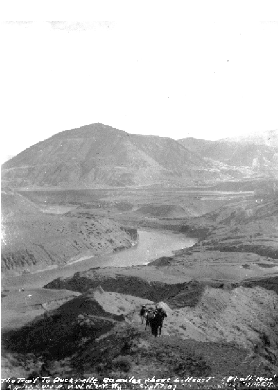 Less celebrated than its wagon-road contemporaries, the Old Cariboo Road
and later on the Cariboo Road
proper, the River Trail (also known as the "Mule Trail") was the choice for most prospectors and travellers heading north from Lillooet who could either not afford the tolls of the Old Cariboo Road, or had no need of it as the River Trail sufficed for foot-travel or horse travel with small packtrains. The wagon roads were built for freight wagons and stage travel, and also went up and over mountains and plateaus which travel via the River Trail did not require. Water was in short supply on this route, which is semi-desert for most of its length as far north as what is now Williams Lake
, and the route was very rugged, but was favoured due to its lower elevation and more temperate climate than the official and more-documented routes eastward over the plateaus. One visitor to Fountain
, then Upper Fountains, a staging ground for wagon trains 10 miles upstream from Lillooet, commented that there were few travellers on the wagon road itself, but that a steady line of men and some horses could be seen threading the difficult valley trail in the canyon-bottom below, "like a line of ants" .
Colony of British Columbia
The Colony of British Columbia was a crown colony in British North America from 1858 until 1866. At its creation, it physically constituted approximately half the present day Canadian province of British Columbia, since it did not include the Colony of Vancouver Island, the vast and still largely...
of what is now the Canadian province of British Columbia
British Columbia
British Columbia is the westernmost of Canada's provinces and is known for its natural beauty, as reflected in its Latin motto, Splendor sine occasu . Its name was chosen by Queen Victoria in 1858...
, running northwards along the Fraser River
Fraser River
The Fraser River is the longest river within British Columbia, Canada, rising at Fraser Pass near Mount Robson in the Rocky Mountains and flowing for , into the Strait of Georgia at the city of Vancouver. It is the tenth longest river in Canada...
from to present day Lillooet
Lillooet, British Columbia
Lillooet is a community on the Fraser River in western Canada, about up the British Columbia Railway line from Vancouver. Situated at an intersection of deep gorges in the lee of the Coast Mountains, it has a dry climate- of precipitation is recorded annually at the town's weather station,...
to Big Bar, British Columbia and points beyond in the Cariboo District
Cariboo
The Cariboo is an intermontane region of British Columbia along a plateau stretching from the Fraser Canyon to the Cariboo Mountains. The name is a reference to the woodland caribou that were once abundant in the region...
. The route was primarily in use during the Fraser Canyon Gold Rush
Fraser Canyon Gold Rush
The Fraser Canyon Gold Rush, began in 1858 after gold was discovered on the Thompson River in British Columbia at its confluence with the Nicoamen River. This was a few miles upstream from the Thompson's confluence with the Fraser River at present-day Lytton...
and associated explorations by prospectors northwards in the search for gold in the Cariboo
Cariboo
The Cariboo is an intermontane region of British Columbia along a plateau stretching from the Fraser Canyon to the Cariboo Mountains. The name is a reference to the woodland caribou that were once abundant in the region...
and Omineca Districts.
Old Cariboo Road
The Old Cariboo Road is a reference to the original wagon road to the Cariboo gold fields in what is now the Canadian province of British Columbia...
and later on the Cariboo Road
Cariboo Road
The Cariboo Road was a project initiated in 1860 by the colonial Governor of British Columbia, James Douglas...
proper, the River Trail (also known as the "Mule Trail") was the choice for most prospectors and travellers heading north from Lillooet who could either not afford the tolls of the Old Cariboo Road, or had no need of it as the River Trail sufficed for foot-travel or horse travel with small packtrains. The wagon roads were built for freight wagons and stage travel, and also went up and over mountains and plateaus which travel via the River Trail did not require. Water was in short supply on this route, which is semi-desert for most of its length as far north as what is now Williams Lake
Williams Lake, British Columbia
Williams Lake, is a city in the Central Interior of British Columbia, Canada. Located in the central part of a region known as the Cariboo, it is the largest urban centre between Kamloops and Prince George, with a population of 11,150 in city limits....
, and the route was very rugged, but was favoured due to its lower elevation and more temperate climate than the official and more-documented routes eastward over the plateaus. One visitor to Fountain
Fountain, British Columbia
Fountain is an unincorporated rural area and Indian Reserve community in the Fraser Canyon region of British Columbia, Canada, located at the ten-mile mark from the town of Lillooet on BC Highway 99, which in that area is also on the route of the Old Cariboo Road and is located at the junction of...
, then Upper Fountains, a staging ground for wagon trains 10 miles upstream from Lillooet, commented that there were few travellers on the wagon road itself, but that a steady line of men and some horses could be seen threading the difficult valley trail in the canyon-bottom below, "like a line of ants" .
See also
- Old Cariboo RoadOld Cariboo RoadThe Old Cariboo Road is a reference to the original wagon road to the Cariboo gold fields in what is now the Canadian province of British Columbia...
- Douglas RoadDouglas RoadThe Douglas Road, aka the Lillooet Trail, Harrison Trail or Lakes Route, was a goldrush-era transportation route from the British Columbia Coast to the Interior...
- Fraser Canyon Gold RushFraser Canyon Gold RushThe Fraser Canyon Gold Rush, began in 1858 after gold was discovered on the Thompson River in British Columbia at its confluence with the Nicoamen River. This was a few miles upstream from the Thompson's confluence with the Fraser River at present-day Lytton...
- Cariboo Gold RushCariboo Gold RushThe Cariboo Gold Rush was a gold rush in the Canadian province of British Columbia. Although the first gold discovery was made in 1859 at Horsefly Creek, followed by more strikes at Keithley Creek and Antler Horns lake in 1860, the actual rush did not begin until 1861, when these discoveries were...
- Hudson's Bay Brigade TrailHudson's Bay Brigade TrailThe Hudson's Bay Brigade Trail, sometimes referred to simply as the Brigade Trail, refers to one of two routes used by Hudson's Bay Company fur traders to transport furs, goods and supplies between coastal and Columbia District headquarters at Fort Vancouver and those in New Caledonia and also in...