

Presidency division
Encyclopedia
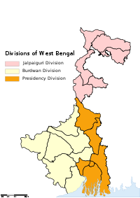
Divisions of West Bengal
The Indian state of Paschimbanga is divided into three administrative Divisions, namely:* Jalpaiguri division* Burdwan division* Presidency division...
in the India
India
India , officially the Republic of India , is a country in South Asia. It is the seventh-largest country by geographical area, the second-most populous country with over 1.2 billion people, and the most populous democracy in the world...
n state
States and territories of India
India is a federal union of states comprising twenty-eight states and seven union territories. The states and territories are further subdivided into districts and so on.-List of states and territories:...
of West Bengal
West Bengal
West Bengal is a state in the eastern region of India and is the nation's fourth-most populous. It is also the seventh-most populous sub-national entity in the world, with over 91 million inhabitants. A major agricultural producer, West Bengal is the sixth-largest contributor to India's GDP...
. It consists of 6 districts
Districts of India
A district is an administrative division of an Indian state or territory. Districts are further subdivided, in some cases into Sub-Divisions, and otherwise directly into tehsils or talukas.District officials include:...
:
- Howrah districtHowrah DistrictHowrah district is a district of the West Bengal state in eastern India. It has thousands of years of rich heritage in the form of the great Bengali kingdom of Bhurshut. The district is named after its headquarters, the city of Howrah.-Geography:...
- Kolkata districtKolkata DistrictKolkata district is an administrative district of the Indian state of West Bengal. It contains the center part of the city of Kolkata. The jurisdiction of the Kolkata...
- Murshidabad districtMurshidabad districtMurshidabad district is a district of West Bengal in eastern India. Situated on the left bank of the river Ganges, the district is very fertile. Covering an area of 5,341 km² and having a population 5.863m it is a densely populated district and the ninth most populous in India...
- Nadia districtNadia DistrictNadia district is a district of the state of West Bengal, in the north east of India. It borders with Bangladesh to the east, North 24 Parganas and Hooghly districts to the south, Bardhaman district to the west, and Murshidabad district to the north....
- North 24 Parganas districtNorth 24 Parganas districtNorth 24 Parganas district is a district in southern West Bengal, of eastern India. North 24 Parganas extends in the [tropical zone] from latitude 22º11'6" north to 23º15'2" north and from longitude 88º20' east to 89º5' east...
- South 24 Parganas districtSouth 24 Parganas districtSouth 24 Parganas district is an important district of West Bengal State with its district headquarters in Alipore. It has the urban fringe of Calcutta on one side and the remote riverine villages in the Sundarbans....