

Desert of Wales
Encyclopedia
Wales
Wales is a country that is part of the United Kingdom and the island of Great Britain, bordered by England to its east and the Atlantic Ocean and Irish Sea to its west. It has a population of three million, and a total area of 20,779 km²...
, so called because of its lack of roads and towns and its inaccessibility. The term was invented by English
England
England is a country that is part of the United Kingdom. It shares land borders with Scotland to the north and Wales to the west; the Irish Sea is to the north west, the Celtic Sea to the south west, with the North Sea to the east and the English Channel to the south separating it from continental...
travel writers in the nineteenth century and its equivalent is not found in the Welsh language
Welsh language
Welsh is a member of the Brythonic branch of the Celtic languages spoken natively in Wales, by some along the Welsh border in England, and in Y Wladfa...
. The area corresponds roughly to the upland area called Elenydd in Welsh and also referred to locally as the Cambrian Mountains
Cambrian Mountains
The Cambrian Mountains are a series of mountain ranges in Wales, reaching from, and including, the South Wales mountains of the Brecon Beacons, north Carmarthenshire and Ceredigion, the Black Mountains of eastern Wales, to Snowdonia in North Wales...
.
Extent
In this case the word "desert" is used in the sense of an area uninhabited by humans (as in "desert islandDesert island
A desert island or uninhabited island is an island that has yet to be populated by humans. Uninhabited islands are often used in movies or stories about shipwrecked people, and are also used as stereotypes for the idea of "paradise". Some uninhabited islands are protected as nature reserves and...
"), not in the sense of an arid desert
Desert
A desert is a landscape or region that receives an extremely low amount of precipitation, less than enough to support growth of most plants. Most deserts have an average annual precipitation of less than...
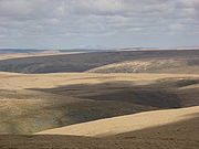
. The area has high rainfall and much of it is covered by peat
Peat
Peat is an accumulation of partially decayed vegetation matter or histosol. Peat forms in wetland bogs, moors, muskegs, pocosins, mires, and peat swamp forests. Peat is harvested as an important source of fuel in certain parts of the world...
overlain with moor grass
Purple Moor Grass
Molinia caerulea is a perennial grass native to Europe, west Asia, and north Africa. It grows in locations from the lowlands up to 2,300 m in the Alps. Like most grasses, it grows best in acid soils, ideally pH values of between 3.5 and 5, however, it can continue to live under more extreme...
or by plantation
Plantation
A plantation is a long artificially established forest, farm or estate, where crops are grown for sale, often in distant markets rather than for local on-site consumption...
s of non-native conifers. The soil tends to be acidic. There is no exact definition of the extent of the Desert of Wales, but it is bordered to the east by the A470
A470 road
The A470 is a major long-distance connective spine road in Wales, running from Cardiff on the south coast to Llandudno on the north coast. It covers approximately 186 miles , over a zig-zagging route through the entirety of the country's mountainous central region, including the Brecon Beacons and...
and the town of Rhayader
Rhayader
Rhayader is a market town and community in Powys, Mid Wales. It has a population of 2,075, and is the first town on the banks of the River Wye, from its source on the Plynlimon range of the Cambrian Mountains....
, to the south by the A483
A483 road
The A483 is a major road in the United Kingdom, running from Swansea in Wales to Chester in England, although the official title is the Swansea to Manchester Trunk Road.-Swansea:...
from Builth Wells
Builth Wells
Builth Wells is a town in the county of Powys, within the historic boundaries of Brecknockshire, mid Wales, lying at the confluence of the River Wye and the River Irfon, in the Welsh of the Wye Valley. It has a population of 2,352....
to Llanwrda
Llanwrda
Llanwrda is a parish and a village on the River Towy, in the county of Carmarthenshire, west Wales, 3½ miles from Llandovery, in the U.K...
, to the west by the A482
A482 road
The A482 road is a major route in the Welsh counties of Ceredigion and Carmarthenshire.It connects Aberaeron on the coast and the A40 road at Llanwrda near Llandovery and is in length.-Route:...
from Llanwrda to Pumpsaint, and from there northwards by a series of country roads up to Tregaron
Tregaron
Tregaron is a market town in the county of Ceredigion, Wales, lying on the River Brenig , a tributary of the River Teifi. The town is twinned with Plouvien, in Finistere, France. According to the 2001 Census, Tregaron's population was 1,183, of whom 68.8% spoke Welsh fluently.-History:Tregaron...
. The northern boundary is generally taken to be the A44
A44 road
The A44 is a major road in the United Kingdom that runs from Oxford in southern England to Aberystwyth in west Wales.-History:The original route of the A44 was Chipping Norton to Aberystwyth. No changes were made to the route of the A44 in the early years...
between Ponterwyd
Ponterwyd
Ponterwyd is a village in Ceredigion, Wales. It lies in the Cambrian Mountains of Mid Wales, approximately 12 miles east of Aberystwyth on the A44 road.-Historical background:...
and Llangurig
Llangurig
Llangurig is a village in Powys, within the historic county boundaries of Montgomeryshire, mid Wales, lying on the River Wye. The population is 670.Llangurig is reputed to be the highest village in Wales at an altitude of 1000 feet...
, although the substantial area of moorland
Moorland
Moorland or moor is a type of habitat, in the temperate grasslands, savannas, and shrublands biome, found in upland areas, characterised by low-growing vegetation on acidic soils and heavy fog...
to the north of this road, including the reservoirs of Nant y Moch
Nant y Moch
Nant-y-moch Reservoir is situated in the Cambrian Mountains in northern Ceredigion, Wales. The reservoir which flooded a part of the valley of the River Rheidol and its headwaters derives its name from a stream, the Nant-y-moch , which formerly flowed into the River Rheidol at this spot. The dam...
and Llyn Clywedog, has similar topography. The term has been used to describe the area since at least 1860 when the following was written:
"The locality we were now traversing is one of the most untamed and desolate in either division of the Principality; it has indeed with perfect truth been called the "great desert of Wales." Vast sweeping ranges of hills with round tops, add to the dreary aspect of this nearly unpeopled region..."
.jpg)
Red Kite
The Red Kite is a medium-large bird of prey in the family Accipitridae, which also includes many other diurnal raptors such as eagles, buzzards, and harriers. The species is currently endemic to the Western Palearctic region in Europe and northwest Africa, though formerly also occurred just...
s, and still supports their most welcome revival since about 1970.
Water Resources
English Midlands
The Midlands, or the English Midlands, is the traditional name for the area comprising central England that broadly corresponds to the early medieval Kingdom of Mercia. It borders Southern England, Northern England, East Anglia and Wales. Its largest city is Birmingham, and it was an important...
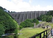
(Claerwen
Claerwen
The Claerwen reservoir and dam in Powys, Wales, were the last additions to the Elan Valley Reservoirs system built to provide water for the increasingly demanding city of Birmingham, in neighbouring England. Built mainly of concrete, the exterior of the dam face is dressed stone. The dam itself is...
group of reservoirs), to the towns of northern Ceredigion
Ceredigion
Ceredigion is a county and former kingdom in mid-west Wales. As Cardiganshire , it was created in 1282, and was reconstituted as a county under that name in 1996, reverting to Ceredigion a day later...
(Teifi Pools), and to towns all along the River Severn
River Severn
The River Severn is the longest river in Great Britain, at about , but the second longest on the British Isles, behind the River Shannon. It rises at an altitude of on Plynlimon, Ceredigion near Llanidloes, Powys, in the Cambrian Mountains of mid Wales...
valley (Llyn Clywedog).
The ruins of Strata Florida Abbey
Strata Florida Abbey
Strata Florida Abbey Flowers. Ystrad corrupts into Strata, while Fflur is the name of the nearby river. After the region around St. David's was firmly occupied by the Norman Marcher lordship of Pembroke by the early 12th century, with St...
on the road from Tregaron
Tregaron
Tregaron is a market town in the county of Ceredigion, Wales, lying on the River Brenig , a tributary of the River Teifi. The town is twinned with Plouvien, in Finistere, France. According to the 2001 Census, Tregaron's population was 1,183, of whom 68.8% spoke Welsh fluently.-History:Tregaron...
have a mystical quality, from both the age of the ruins and their location.