
Nant y Moch
Encyclopedia
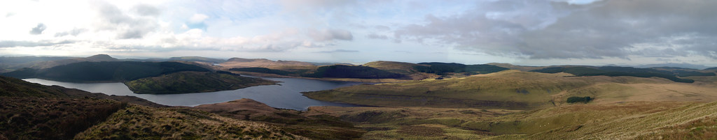
Nant-y-moch Reservoir is situated in the Cambrian Mountains
in northern Ceredigion
, Wales
. The reservoir which flooded a part of the valley of the River Rheidol and its headwaters derives its name from a stream, the Nant-y-moch (in English
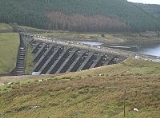
= the pigs stream,), which formerly flowed into the River Rheidol at this spot. The dam
is about three miles north of the village of Ponterwyd
. The reservoir forms part of the Cwm Rheidol hydroelectric power scheme and the headwaters of the reservoir include the source of the River Rheidol. The Nant-y-moch component of the hydroelectric scheme has an installed capacity of 13 MW generated as the water from Nant-y-moch enters Dinas Reservoir
The area of Nant-y-moch is currently part of the location for a huge scale wind-turbine development, a project over which there is growing controversy in the area. Scottish and Southern Energy plc (SSE) is planning to build 60 to 80 turbines each proposed to be 145m or 475 feet tall. This is one and a half times the height of Big Ben, and as much as three times the height of turbines used in much smaller earlier projects in Ceredigion. Opponents argue that the benefits of the projects, and approximate constant of 128 - 160MW does not justify the impact on the landscape .
, and a number of cairns
were painstakingly moved, some of which dated back as far as the Iron Age
.
Cambrian Mountains
The Cambrian Mountains are a series of mountain ranges in Wales, reaching from, and including, the South Wales mountains of the Brecon Beacons, north Carmarthenshire and Ceredigion, the Black Mountains of eastern Wales, to Snowdonia in North Wales...
in northern Ceredigion
Ceredigion
Ceredigion is a county and former kingdom in mid-west Wales. As Cardiganshire , it was created in 1282, and was reconstituted as a county under that name in 1996, reverting to Ceredigion a day later...
, Wales
Wales
Wales is a country that is part of the United Kingdom and the island of Great Britain, bordered by England to its east and the Atlantic Ocean and Irish Sea to its west. It has a population of three million, and a total area of 20,779 km²...
. The reservoir which flooded a part of the valley of the River Rheidol and its headwaters derives its name from a stream, the Nant-y-moch (in English
English language
English is a West Germanic language that arose in the Anglo-Saxon kingdoms of England and spread into what was to become south-east Scotland under the influence of the Anglian medieval kingdom of Northumbria...
= the pigs stream,), which formerly flowed into the River Rheidol at this spot. The dam
Dam
A dam is a barrier that impounds water or underground streams. Dams generally serve the primary purpose of retaining water, while other structures such as floodgates or levees are used to manage or prevent water flow into specific land regions. Hydropower and pumped-storage hydroelectricity are...
is about three miles north of the village of Ponterwyd
Ponterwyd
Ponterwyd is a village in Ceredigion, Wales. It lies in the Cambrian Mountains of Mid Wales, approximately 12 miles east of Aberystwyth on the A44 road.-Historical background:...
. The reservoir forms part of the Cwm Rheidol hydroelectric power scheme and the headwaters of the reservoir include the source of the River Rheidol. The Nant-y-moch component of the hydroelectric scheme has an installed capacity of 13 MW generated as the water from Nant-y-moch enters Dinas Reservoir
The area of Nant-y-moch is currently part of the location for a huge scale wind-turbine development, a project over which there is growing controversy in the area. Scottish and Southern Energy plc (SSE) is planning to build 60 to 80 turbines each proposed to be 145m or 475 feet tall. This is one and a half times the height of Big Ben, and as much as three times the height of turbines used in much smaller earlier projects in Ceredigion. Opponents argue that the benefits of the projects, and approximate constant of 128 - 160MW does not justify the impact on the landscape .
History
Nant-y-moch Reservoir was created in 1964. The construction of the dam flooded the valley south of it, which included the hamlet of Nant-y-moch. The contents of the graveyard which was to be submerged were relocated to the chapel at PonterwydPonterwyd
Ponterwyd is a village in Ceredigion, Wales. It lies in the Cambrian Mountains of Mid Wales, approximately 12 miles east of Aberystwyth on the A44 road.-Historical background:...
, and a number of cairns
Cairn
Cairn is a term used mainly in the English-speaking world for a man-made pile of stones. It comes from the or . Cairns are found all over the world in uplands, on moorland, on mountaintops, near waterways and on sea cliffs, and also in barren desert and tundra areas...
were painstakingly moved, some of which dated back as far as the Iron Age
Iron Age
The Iron Age is the archaeological period generally occurring after the Bronze Age, marked by the prevalent use of iron. The early period of the age is characterized by the widespread use of iron or steel. The adoption of such material coincided with other changes in society, including differing...
.