
Delta Junction, Alaska
Encyclopedia
Delta Junction is a city in the Southeast Fairbanks Census Area, Alaska
, United States. According to 2005 Census Bureau estimates, the population of the city is 897. The city is located a short distance south of the confluence of the Delta River
with the Tanana River
, which is at Big Delta
. It is about 160 km (99.4 mi) south of Fairbanks
.
According to the United States Census Bureau
, the city has a total area of 17.3 square miles (44.8 km²), all of it land.
"Big Delta" lies at the intersection of the Delta River
and the Tanana River
. The City of Delta Junction sits on the Delta River at the intersection of the Richardson Highway and the famed Alaska Highway (actually, the end of the Alaska Highway). The city and Delta community lie within the fertile Tanana River valley. Three mountain ranges—the White Mountains to the north, the Granite Mountains to the southeast, and the Alaska Range
to the southwest—and the Delta River to the west surround the city.
Once overlain by glaciers, the geology is marked by glacial moraines as well as alluvial deposits from the Delta and Tanana Rivers. Numerous mineral deposits are found in the vicinity of Delta Junction ranging from gold to molybdenum to coal. A prominent natural feature on the landscape is Donnelly Dome, located within the Donnelly Training Area of Fort Wainwright (formerly a part of nearby Fort Greely until 2001), to the south of Delta Junction. This dome was formed as a glacier coming from the Alaska Range split in two, carving away sides of a former mountain.
, 1.07% Black
or African American
, 4.05% Native American
, 0.95% Asian
, 0.12% from other races
, and 2.38% from two or more races. 0.83% of the population were Hispanic
or Latino
of any race.
There were 312 households out of which 35.6% had children under the age of 18 living with them, 52.6% were married couples living together, 9.0% had a female householder with no husband present, and 33.3% were non-families. 28.8% of all households were made up of individuals and 6.4% had someone living alone who was 65 years of age or older. The average household size was 2.69 and the average family size was 3.32.
In the city the age distribution of the population shows 32.6% under the age of 18, 6.5% from 18 to 24, 26.5% from 25 to 44, 26.5% from 45 to 64, and 7.7% who were 65 years of age or older. The median age was 36 years. For every 100 females there were 112.1 males. For every 100 females age 18 and over, there were 109.6 males.
The median income for a household in the city was $43,500, and the median income for a family was $58,250. Males had a median income of $50,469 versus $25,750 for females. The per capita income
for the city was $19,171. About 12.3% of families and 19.4% of the population were below the poverty line, including 28.8% of those under age 18 and 13.2% of those age 65 or over.
 For at least 10,000 years, Athabascan Indians have inhabited portions of the interior of Alaska
. Early inhabitants survived by hunting and fishing.
The early history of non-native settlement in the area occurred at the river crossing at Big Delta and is found at the entry, Big Delta, Alaska
.
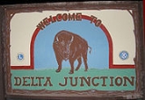
In 1928 a herd of 23 bison
were brought from the National Bison Range
in Montana
to an area south of Big Delta to provide an additional game species for hunters. Buffalo Center, a small community near the center of present day Delta Junction, was named because of their presence, especially during the winter months. The huge animals were troublesome, and sometimes made landings dangerous at nearby Allen Army Airfield.
The herd is now kept at several hundred animals by the annual issuance of hunting permits. In the early 1980s, the 90000 acres (364.2 km²) Delta Junction Bison Range, south of the Alaska Highway and between Ft. Greely and the Little Gerstle River was established; the range is now managed by the Alaska Department of Fish and Game to provide fall habitat for bison to reduce farm depredations and to provide habitat for other wildlife.
 During World War II the United States aided the Soviet Union against Germany by sending airplanes and supplies authorized by the Lend-lease
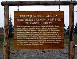
Act to the Soviet Union through Alaska into the Russian Far East. The Alaska Highway
was built to connect an existing road in Dawson Creek, British Columbia
, Canada, with the Richardson Highway
in Alaska, a distance of 2290 km (1,422.9 mi).
The Alaska Highway met the Richardson Highway at a point 12 km (7.5 mi) south along the Delta River from Big Delta. The place where the highways met became known as Delta Junction. Allen Army Airfield was constructed 5 miles (8 km) south of Delta Junction for use in sending supplies to Russia. The Glenn Highway
was built from Anchorage
to what is now Glennallen
, where it met the Richardson Highway. This connection created a motor route between Anchorage and Fairbanks, Alaska.
After World War II a U.S. army base, Fort Greely
, was built next to the air field. The base and a huge tract of land around it was used for training soldiers for cold weather combat during the Cold War
with the former Soviet Union.
In 1957 the Richardson Highway was paved. About this time portions of the Alaska Highway were also paved. The army base and tourism brought on the highways caused a boom in the area's economy and the commercial center of the area moved from Big Delta to Delta Junction. After World War II some people also began farming and raising livestock in the Delta Junction area. This farming required new techniques to accommodate the short growing season and the cold and dark winters of interior Alaska.
Delta Junction was incorporated as a municipality in 1960. Oil
was discovered in the North Slope
of Alaska in 1968. In 1974 construction began on the pipeline
to transport the oil from the North Slope to Valdez. The pipeline construction also aided the economy of the area. Delta Junction experienced a temporary boom similar to the gold rush that resulted in a wave of new residents and businesses in the community. Cost of living during this period was well above the national average due to transportation costs as well as gouging. Prostitution and bars flourished — as did churches and religious communes.
In the late 1970s and early 1980s, the Tanana Valley
was designated as a potential agricultural area for Alaska. The state of Alaska then made large tracts of land available to future farmers for purchase. Significant was establishment of the "Barley Project" east of the city. Plans were made to grow barley, ship it to Valdez
via a future rail terminal, and from there ship it overseas to Asia. Though farms were established and a storage facility constructed in Valdez, the railroad never came, essentially resulting in the failure of the project. Political pressure and growing costs resulted in the project being defunded upon change in governors. Today, these original farms are primarily used as pasture or for hay production though barley
, potato
es, carrot
s, and even wheat
are still grown with limited commercial success. With the availability of a nearby meat processing facility (Delta Meat and Sausage Company), many farmers turned to cattle with limited success. In addition, the area is now known for production of exotic meats such as yak
, bison, and elk
.
In the 1980s, the pipeline construction ended. The Cold War also ended with the collapse of the Soviet Union. A new highway, the George Parks Highway
, was built between Anchorage and Fairbanks. This highway followed the railroad route and was a shorter route for motorists traveling between Anchorage and Fairbanks than the Glenn and Richardson Highway route. Many travelers used the new highway, bypassing Delta Junction. These events caused a decline in the economy of Delta Junction.
During the 1990s and 2000s, immigrants from the former Soviet republics came to the area, significantly changing the makeup of the local population.
Fort Greely was included on the Base Realignment and Closure
(BRAC) list in 1995. From 1995 to 2002, Fort Greely was gradually re-aligned through a gradual drawdown in both military and civilian personnel. Once BRAC was complete in 2002, Fort Greely remained open but was staffed with less than 100 military and civilian personnel. During this time the remaining workers were either associated with public works functions or the Cold Regions Test Center, which continued testing on the installation. Headquarters for both the Cold Regions Test Center and the Northern Warfare Training Center moved to Fort Wainwright in Fairbanks in 2002. Base housing and numerous surplus buildings remained vacant, though the Army continued heating and maintaining them.
Re-alignment of Fort Greely resulted in heated discussion throughout the Delta Junction community over a proposal to site a privately operated state prison
within surplus buildings on Fort Greely. Eventually, the City of Delta Junction entered into a contract with Allvest Corporation to operate this prison. Plans for the prison eventually fell through. Allvest Corporation subsequently sued Delta Junction for $1 million for breach of contract.
Shortly after BRAC was complete, the United States government announced plans to build a missile defense installation at Ft. Greely. The installation was then divided into two parts operated by two different commands — U.S. Army Garrison Alaska and Space and Missile Defense Command. The main post retained the name Fort Greely and is operated by the Space and Missile Defense Command. Outlying range, training and impact areas were absorbed by Fort Wainwright and were renamed Donnelly Training Area.
From 2002 to 2005, Delta Junction experienced an economic boom similar to the pipeline days as Fort Greely became fully operational again and the missile test bed was constructed. National firms such as Boeing
, Bechtel
, and Brown and Root, as well as regional firms including Chugach opened up offices on the installation, under contract to the government. Construction of the Pogo Gold Mine just north of Delta Junction, near the Goodpaster River, also contributed significantly to the economic fortune of the city. Mineral deposits near Tangle Lakes, south of Delta Junction, will likely result in additional development of mining in the area.
A railroad
spur from Fairbanks to Delta Junction has been proposed to transport material to the missile defense site. This should spur other types of industry in Delta Junction, as the railroad could transport agricultural products out of the area as well as promote tourist travel into the area by rail.
Many people in Delta Junction supplement their food supply by hunting the moose
, caribou
, Dall sheep
and bison in the area, as well as fishing. A few operate small gold mines or hunt or trap fur-bearing animals for extra income.
Delta Junction, like most Alaska communities, has a small airstrip where charter flights are available for sightseeing, hunting and fishing.
Due to limited shopping availability, many residents travel to Fairbanks via the Richardson Highway to purchase goods and services. Though Delta has a clinic, primary medical care is also in Fairbanks.
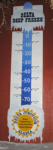 As it is not near the ocean, this area is drier than coastal Alaska and experiences seasonal extremes typical of subarctic areas. The annual precipitation is only 30.5 cm (12 inches), including 94 cm (37 inches) of snow. The average low temperature in January is -23 °C (-11 °F). The average high during July is +20 °C (+69 °F). Temperature extremes have been recorded from -53 °C to +33 °C (-63 °F to +92 °F).
Delta Junction is mostly sunny in the summer and split between clear and overcast days in the winter. On clear winter nights, the aurora borealis can often be seen dancing in the sky. Like all subarctic regions, the months from May to July in the summer have no night, only a twilight during the night hours. The months of November to January have 4 to 5 daylight and twilight hours.
Delta Junction was known as the "Windy City" and "Little Chicago" by many soldiers on Fort Greely, a reference to Chicago
in the lower 48 United States. In Delta Junction itself, but not in the nearby areas, wind blows many days from the south up the Delta River from the Gulf of Alaska
, bringing river silt in the summer and snowdrifts in the winter. There are usually several days in the winter when the temperature is in the range of -40° (C or F) when a wind (known as a Chinook wind
) begins to blow. A few minutes later, the temperature climbs to above 0 °C (+32 °F). When the wind stops, the temperature returns to its colder value.
Delta Junction's prevailing winds are from the east.
Southeast Fairbanks Census Area, Alaska
Southeast Fairbanks Census Area is a census area located in the state of Alaska, United States. As of the 2000 census, the population was 6,174. It is part of the unorganized borough and therefore has no borough seat...
, United States. According to 2005 Census Bureau estimates, the population of the city is 897. The city is located a short distance south of the confluence of the Delta River
Delta River
The Delta River is a tributary of the Tanana River, which in turn is a tributary of the Yukon River in Alaska in the United States....
with the Tanana River
Tanana River
The Tanana River is a tributary of the Yukon River in the U.S. state of Alaska. According to linguist and anthropologist William Bright, the name is from the Koyukon tene no, tenene, literally "trail river"....
, which is at Big Delta
Big Delta, Alaska
Big Delta is a census-designated place in Southeast Fairbanks Census Area, Alaska, United States. The population was 749 at the 2000 census...
. It is about 160 km (99.4 mi) south of Fairbanks
Fairbanks, Alaska
Fairbanks is a home rule city in and the borough seat of the Fairbanks North Star Borough in the U.S. state of Alaska.Fairbanks is the largest city in the Interior region of Alaska, and second largest in the state behind Anchorage...
.
Geography
Delta Junction is located at 64°2′52"N 145°43′7"W (64.047669, -145.718655).According to the United States Census Bureau
United States Census Bureau
The United States Census Bureau is the government agency that is responsible for the United States Census. It also gathers other national demographic and economic data...
, the city has a total area of 17.3 square miles (44.8 km²), all of it land.
"Big Delta" lies at the intersection of the Delta River
Delta River
The Delta River is a tributary of the Tanana River, which in turn is a tributary of the Yukon River in Alaska in the United States....
and the Tanana River
Tanana River
The Tanana River is a tributary of the Yukon River in the U.S. state of Alaska. According to linguist and anthropologist William Bright, the name is from the Koyukon tene no, tenene, literally "trail river"....
. The City of Delta Junction sits on the Delta River at the intersection of the Richardson Highway and the famed Alaska Highway (actually, the end of the Alaska Highway). The city and Delta community lie within the fertile Tanana River valley. Three mountain ranges—the White Mountains to the north, the Granite Mountains to the southeast, and the Alaska Range
Alaska Range
The Alaska Range is a relatively narrow, 650-km-long mountain range in the southcentral region of the U.S. state of Alaska, from Lake Clark at its southwest end to the White River in Canada's Yukon Territory in the southeast...
to the southwest—and the Delta River to the west surround the city.
Once overlain by glaciers, the geology is marked by glacial moraines as well as alluvial deposits from the Delta and Tanana Rivers. Numerous mineral deposits are found in the vicinity of Delta Junction ranging from gold to molybdenum to coal. A prominent natural feature on the landscape is Donnelly Dome, located within the Donnelly Training Area of Fort Wainwright (formerly a part of nearby Fort Greely until 2001), to the south of Delta Junction. This dome was formed as a glacier coming from the Alaska Range split in two, carving away sides of a former mountain.
Demographics
As of the census of 2000, there were 840 people, 312 households, and 208 families residing in the city. The population density was 48.7 people per square mile (18.8/km²). There were 422 housing units at an average density of 24.4 per square mile (9.4/km²). The racial makeup of the city was 91.43% WhiteRace (United States Census)
Race and ethnicity in the United States Census, as defined by the Federal Office of Management and Budget and the United States Census Bureau, are self-identification data items in which residents choose the race or races with which they most closely identify, and indicate whether or not they are...
, 1.07% Black
Race (United States Census)
Race and ethnicity in the United States Census, as defined by the Federal Office of Management and Budget and the United States Census Bureau, are self-identification data items in which residents choose the race or races with which they most closely identify, and indicate whether or not they are...
or African American
Race (United States Census)
Race and ethnicity in the United States Census, as defined by the Federal Office of Management and Budget and the United States Census Bureau, are self-identification data items in which residents choose the race or races with which they most closely identify, and indicate whether or not they are...
, 4.05% Native American
Race (United States Census)
Race and ethnicity in the United States Census, as defined by the Federal Office of Management and Budget and the United States Census Bureau, are self-identification data items in which residents choose the race or races with which they most closely identify, and indicate whether or not they are...
, 0.95% Asian
Race (United States Census)
Race and ethnicity in the United States Census, as defined by the Federal Office of Management and Budget and the United States Census Bureau, are self-identification data items in which residents choose the race or races with which they most closely identify, and indicate whether or not they are...
, 0.12% from other races
Race (United States Census)
Race and ethnicity in the United States Census, as defined by the Federal Office of Management and Budget and the United States Census Bureau, are self-identification data items in which residents choose the race or races with which they most closely identify, and indicate whether or not they are...
, and 2.38% from two or more races. 0.83% of the population were Hispanic
Race (United States Census)
Race and ethnicity in the United States Census, as defined by the Federal Office of Management and Budget and the United States Census Bureau, are self-identification data items in which residents choose the race or races with which they most closely identify, and indicate whether or not they are...
or Latino
Race (United States Census)
Race and ethnicity in the United States Census, as defined by the Federal Office of Management and Budget and the United States Census Bureau, are self-identification data items in which residents choose the race or races with which they most closely identify, and indicate whether or not they are...
of any race.
There were 312 households out of which 35.6% had children under the age of 18 living with them, 52.6% were married couples living together, 9.0% had a female householder with no husband present, and 33.3% were non-families. 28.8% of all households were made up of individuals and 6.4% had someone living alone who was 65 years of age or older. The average household size was 2.69 and the average family size was 3.32.
In the city the age distribution of the population shows 32.6% under the age of 18, 6.5% from 18 to 24, 26.5% from 25 to 44, 26.5% from 45 to 64, and 7.7% who were 65 years of age or older. The median age was 36 years. For every 100 females there were 112.1 males. For every 100 females age 18 and over, there were 109.6 males.
The median income for a household in the city was $43,500, and the median income for a family was $58,250. Males had a median income of $50,469 versus $25,750 for females. The per capita income
Per capita income
Per capita income or income per person is a measure of mean income within an economic aggregate, such as a country or city. It is calculated by taking a measure of all sources of income in the aggregate and dividing it by the total population...
for the city was $19,171. About 12.3% of families and 19.4% of the population were below the poverty line, including 28.8% of those under age 18 and 13.2% of those age 65 or over.
History
Alaska
Alaska is the largest state in the United States by area. It is situated in the northwest extremity of the North American continent, with Canada to the east, the Arctic Ocean to the north, and the Pacific Ocean to the west and south, with Russia further west across the Bering Strait...
. Early inhabitants survived by hunting and fishing.
The early history of non-native settlement in the area occurred at the river crossing at Big Delta and is found at the entry, Big Delta, Alaska
Big Delta, Alaska
Big Delta is a census-designated place in Southeast Fairbanks Census Area, Alaska, United States. The population was 749 at the 2000 census...
.
In 1928 a herd of 23 bison
Plains Bison
The Plains Bison or Common bison is one of two subspecies/ecotypes of the American Bison, the other being the Wood Bison . Furthermore, it has been suggested that the Plains Bison consists of a northern and a southern subspecies, bringing the total to three...
were brought from the National Bison Range
National Bison Range
The National Bison Range is a National Wildlife Refuge located in western Montana established in 1908 to provide a sanctuary for the American bison. The NBR is one of the oldest National Wildlife Refuges in the United States. The size of the bison herd at the NBR is relatively small, numbering...
in Montana
Montana
Montana is a state in the Western United States. The western third of Montana contains numerous mountain ranges. Smaller, "island ranges" are found in the central third of the state, for a total of 77 named ranges of the Rocky Mountains. This geographical fact is reflected in the state's name,...
to an area south of Big Delta to provide an additional game species for hunters. Buffalo Center, a small community near the center of present day Delta Junction, was named because of their presence, especially during the winter months. The huge animals were troublesome, and sometimes made landings dangerous at nearby Allen Army Airfield.
The herd is now kept at several hundred animals by the annual issuance of hunting permits. In the early 1980s, the 90000 acres (364.2 km²) Delta Junction Bison Range, south of the Alaska Highway and between Ft. Greely and the Little Gerstle River was established; the range is now managed by the Alaska Department of Fish and Game to provide fall habitat for bison to reduce farm depredations and to provide habitat for other wildlife.
Lend-Lease
Lend-Lease was the program under which the United States of America supplied the United Kingdom, the Soviet Union, China, Free France, and other Allied nations with materiel between 1941 and 1945. It was signed into law on March 11, 1941, a year and a half after the outbreak of war in Europe in...
Act to the Soviet Union through Alaska into the Russian Far East. The Alaska Highway
Alaska Highway
The Alaska Highway was constructed during World War II for the purpose of connecting the contiguous U.S. to Alaska through Canada. It begins at the junction with several Canadian highways in Dawson Creek, British Columbia and runs to Delta Junction, Alaska, via Whitehorse, Yukon...
was built to connect an existing road in Dawson Creek, British Columbia
Dawson Creek, British Columbia
Dawson Creek is a small city in northeastern British Columbia, Canada. The municipality of had a population of 11,529 in 2009. Dawson Creek derives its name from the creek of the same name that runs through the community. The creek was named after George Mercer Dawson by a member of his land...
, Canada, with the Richardson Highway
Richardson Highway
The Richardson Highway is a highway in the U.S. state of Alaska, running 368 miles from Valdez to Fairbanks. It is marked as Alaska Route 4 from Valdez to Delta Junction and as Alaska Route 2 from there to Fairbanks. It is also connects segments of Alaska Route 1 between the Glenn Highway and the...
in Alaska, a distance of 2290 km (1,422.9 mi).
The Alaska Highway met the Richardson Highway at a point 12 km (7.5 mi) south along the Delta River from Big Delta. The place where the highways met became known as Delta Junction. Allen Army Airfield was constructed 5 miles (8 km) south of Delta Junction for use in sending supplies to Russia. The Glenn Highway
Glenn Highway
-References:* Pasch, A. D., K. C. May. 2001. Taphonomy and paleoenvironment of hadrosaur from the Matanuska Formation in South-Central Alaska. In: Mesozioc Vertebrate Life. Ed.s Tanke, D. H., Carpenter, K., Skrepnick, M. W. Indiana University Press. Pages 219-236.-External links:**...
was built from Anchorage
Anchorage, Alaska
Anchorage is a unified home rule municipality in the southcentral part of the U.S. state of Alaska. It is the northernmost major city in the United States...
to what is now Glennallen
Glennallen, Alaska
Glennallen is a census-designated place in the Valdez-Cordova Census Area in the Unorganized Borough of the U.S. state of Alaska. As of the 2000 census, the population of the CDP was 554.- Location :...
, where it met the Richardson Highway. This connection created a motor route between Anchorage and Fairbanks, Alaska.
After World War II a U.S. army base, Fort Greely
Fort Greely
Fort Greely is a United States Army launch site for anti-ballistic missiles located approximately 100 miles southeast of Fairbanks, Alaska. It is also the home of the Cold Regions Test Center , as Fort Greely is one of the coldest areas in Alaska, and can accommodate cold, extreme cold, or...
, was built next to the air field. The base and a huge tract of land around it was used for training soldiers for cold weather combat during the Cold War
Cold War
The Cold War was the continuing state from roughly 1946 to 1991 of political conflict, military tension, proxy wars, and economic competition between the Communist World—primarily the Soviet Union and its satellite states and allies—and the powers of the Western world, primarily the United States...
with the former Soviet Union.
In 1957 the Richardson Highway was paved. About this time portions of the Alaska Highway were also paved. The army base and tourism brought on the highways caused a boom in the area's economy and the commercial center of the area moved from Big Delta to Delta Junction. After World War II some people also began farming and raising livestock in the Delta Junction area. This farming required new techniques to accommodate the short growing season and the cold and dark winters of interior Alaska.
Delta Junction was incorporated as a municipality in 1960. Oil
Oil
An oil is any substance that is liquid at ambient temperatures and does not mix with water but may mix with other oils and organic solvents. This general definition includes vegetable oils, volatile essential oils, petrochemical oils, and synthetic oils....
was discovered in the North Slope
Alaska North Slope
The Alaska North Slope is the region of the U.S. state of Alaska located on the northern slope of the Brooks Range along the coast of two marginal seas of the Arctic Ocean, the Chukchi Sea being on the western side of Point Barrow, and the Beaufort Sea on the eastern.The region contains the...
of Alaska in 1968. In 1974 construction began on the pipeline
Trans-Alaska Pipeline System
The Trans Alaska Pipeline System , includes the Trans Alaska Pipeline, 11 pump stations, several hundred miles of feeder pipelines, and the Valdez Marine Terminal. TAPS is one of the world's largest pipeline systems...
to transport the oil from the North Slope to Valdez. The pipeline construction also aided the economy of the area. Delta Junction experienced a temporary boom similar to the gold rush that resulted in a wave of new residents and businesses in the community. Cost of living during this period was well above the national average due to transportation costs as well as gouging. Prostitution and bars flourished — as did churches and religious communes.
In the late 1970s and early 1980s, the Tanana Valley
Tanana Valley
The Tanana Valley is a lowland region in central Alaska in the United States, on the north side of the Alaska Range where the Tanana River emerges from the mountains.-Climate:...
was designated as a potential agricultural area for Alaska. The state of Alaska then made large tracts of land available to future farmers for purchase. Significant was establishment of the "Barley Project" east of the city. Plans were made to grow barley, ship it to Valdez
Valdez, Alaska
Valdez is a city in Valdez-Cordova Census Area in the U.S. state of Alaska. According to 2005 Census Bureau estimates, the population of the city is 4,020. The city is one of the most important ports in Alaska. The port of Valdez was named in 1790 after the Spanish naval officer Antonio Valdés y...
via a future rail terminal, and from there ship it overseas to Asia. Though farms were established and a storage facility constructed in Valdez, the railroad never came, essentially resulting in the failure of the project. Political pressure and growing costs resulted in the project being defunded upon change in governors. Today, these original farms are primarily used as pasture or for hay production though barley
Barley
Barley is a major cereal grain, a member of the grass family. It serves as a major animal fodder, as a base malt for beer and certain distilled beverages, and as a component of various health foods...
, potato
Potato
The potato is a starchy, tuberous crop from the perennial Solanum tuberosum of the Solanaceae family . The word potato may refer to the plant itself as well as the edible tuber. In the region of the Andes, there are some other closely related cultivated potato species...
es, carrot
Carrot
The carrot is a root vegetable, usually orange in colour, though purple, red, white, and yellow varieties exist. It has a crisp texture when fresh...
s, and even wheat
Wheat
Wheat is a cereal grain, originally from the Levant region of the Near East, but now cultivated worldwide. In 2007 world production of wheat was 607 million tons, making it the third most-produced cereal after maize and rice...
are still grown with limited commercial success. With the availability of a nearby meat processing facility (Delta Meat and Sausage Company), many farmers turned to cattle with limited success. In addition, the area is now known for production of exotic meats such as yak
Yak
The yak, Bos grunniens or Bos mutus, is a long-haired bovine found throughout the Himalayan region of south Central Asia, the Tibetan Plateau and as far north as Mongolia and Russia. In addition to a large domestic population, there is a small, vulnerable wild yak population...
, bison, and elk
Elk
The Elk is the large deer, also called Cervus canadensis or wapiti, of North America and eastern Asia.Elk may also refer to:Other antlered mammals:...
.
In the 1980s, the pipeline construction ended. The Cold War also ended with the collapse of the Soviet Union. A new highway, the George Parks Highway
George Parks Highway
The George Parks Highway , usually called simply the Parks Highway, runs 323 miles from the Glenn Highway 35 miles north of Anchorage to Fairbanks in the Alaska Interior...
, was built between Anchorage and Fairbanks. This highway followed the railroad route and was a shorter route for motorists traveling between Anchorage and Fairbanks than the Glenn and Richardson Highway route. Many travelers used the new highway, bypassing Delta Junction. These events caused a decline in the economy of Delta Junction.
During the 1990s and 2000s, immigrants from the former Soviet republics came to the area, significantly changing the makeup of the local population.
Fort Greely was included on the Base Realignment and Closure
Base Realignment and Closure
Base Realignment and Closure is a process of the United States federal government directed at the administration and operation of the Armed Forces, used by the United States Department of Defense and Congress to close excess military installations and realign the total asset inventory to reduce...
(BRAC) list in 1995. From 1995 to 2002, Fort Greely was gradually re-aligned through a gradual drawdown in both military and civilian personnel. Once BRAC was complete in 2002, Fort Greely remained open but was staffed with less than 100 military and civilian personnel. During this time the remaining workers were either associated with public works functions or the Cold Regions Test Center, which continued testing on the installation. Headquarters for both the Cold Regions Test Center and the Northern Warfare Training Center moved to Fort Wainwright in Fairbanks in 2002. Base housing and numerous surplus buildings remained vacant, though the Army continued heating and maintaining them.
Re-alignment of Fort Greely resulted in heated discussion throughout the Delta Junction community over a proposal to site a privately operated state prison
Prison
A prison is a place in which people are physically confined and, usually, deprived of a range of personal freedoms. Imprisonment or incarceration is a legal penalty that may be imposed by the state for the commission of a crime...
within surplus buildings on Fort Greely. Eventually, the City of Delta Junction entered into a contract with Allvest Corporation to operate this prison. Plans for the prison eventually fell through. Allvest Corporation subsequently sued Delta Junction for $1 million for breach of contract.
Shortly after BRAC was complete, the United States government announced plans to build a missile defense installation at Ft. Greely. The installation was then divided into two parts operated by two different commands — U.S. Army Garrison Alaska and Space and Missile Defense Command. The main post retained the name Fort Greely and is operated by the Space and Missile Defense Command. Outlying range, training and impact areas were absorbed by Fort Wainwright and were renamed Donnelly Training Area.
From 2002 to 2005, Delta Junction experienced an economic boom similar to the pipeline days as Fort Greely became fully operational again and the missile test bed was constructed. National firms such as Boeing
Boeing
The Boeing Company is an American multinational aerospace and defense corporation, founded in 1916 by William E. Boeing in Seattle, Washington. Boeing has expanded over the years, merging with McDonnell Douglas in 1997. Boeing Corporate headquarters has been in Chicago, Illinois since 2001...
, Bechtel
Bechtel
Bechtel Corporation is the largest engineering company in the United States, ranking as the 5th-largest privately owned company in the U.S...
, and Brown and Root, as well as regional firms including Chugach opened up offices on the installation, under contract to the government. Construction of the Pogo Gold Mine just north of Delta Junction, near the Goodpaster River, also contributed significantly to the economic fortune of the city. Mineral deposits near Tangle Lakes, south of Delta Junction, will likely result in additional development of mining in the area.
Economy
Construction and maintenance of the military facilities, mining, agriculture, tourism and their support industries form the backbone of the area economy.A railroad
Alaska Railroad
The Alaska Railroad is a Class II railroad which extends from Seward and Whittier, in the south of the state of Alaska, in the United States, to Fairbanks , and beyond to Eielson Air Force Base and Fort Wainwright in the interior of that state...
spur from Fairbanks to Delta Junction has been proposed to transport material to the missile defense site. This should spur other types of industry in Delta Junction, as the railroad could transport agricultural products out of the area as well as promote tourist travel into the area by rail.
Many people in Delta Junction supplement their food supply by hunting the moose
Moose
The moose or Eurasian elk is the largest extant species in the deer family. Moose are distinguished by the palmate antlers of the males; other members of the family have antlers with a dendritic configuration...
, caribou
Reindeer
The reindeer , also known as the caribou in North America, is a deer from the Arctic and Subarctic, including both resident and migratory populations. While overall widespread and numerous, some of its subspecies are rare and one has already gone extinct.Reindeer vary considerably in color and size...
, Dall sheep
Dall Sheep
The Dall sheep , Ovis dalli, is a species of sheep native to northwestern North America, ranging from white to slate brown in color and having curved yellowish brown horns...
and bison in the area, as well as fishing. A few operate small gold mines or hunt or trap fur-bearing animals for extra income.
Delta Junction, like most Alaska communities, has a small airstrip where charter flights are available for sightseeing, hunting and fishing.
Due to limited shopping availability, many residents travel to Fairbanks via the Richardson Highway to purchase goods and services. Though Delta has a clinic, primary medical care is also in Fairbanks.
Education
In 2007, Delta Junction Elementary School was named a National Blue Ribbon School.Climate
Delta Junction is mostly sunny in the summer and split between clear and overcast days in the winter. On clear winter nights, the aurora borealis can often be seen dancing in the sky. Like all subarctic regions, the months from May to July in the summer have no night, only a twilight during the night hours. The months of November to January have 4 to 5 daylight and twilight hours.
Delta Junction was known as the "Windy City" and "Little Chicago" by many soldiers on Fort Greely, a reference to Chicago
Chicago
Chicago is the largest city in the US state of Illinois. With nearly 2.7 million residents, it is the most populous city in the Midwestern United States and the third most populous in the US, after New York City and Los Angeles...
in the lower 48 United States. In Delta Junction itself, but not in the nearby areas, wind blows many days from the south up the Delta River from the Gulf of Alaska
Gulf of Alaska
The Gulf of Alaska is an arm of the Pacific Ocean defined by the curve of the southern coast of Alaska, stretching from the Alaska Peninsula and Kodiak Island in the west to the Alexander Archipelago in the east, where Glacier Bay and the Inside Passage are found.The entire shoreline of the Gulf is...
, bringing river silt in the summer and snowdrifts in the winter. There are usually several days in the winter when the temperature is in the range of -40° (C or F) when a wind (known as a Chinook wind
Chinook wind
Chinook winds , often called chinooks, commonly refers to foehn winds in the interior West of North America, where the Canadian Prairies and Great Plains meet various mountain ranges, although the original usage is in reference to wet, warm coastal winds in the Pacific Northwest.Chinook is claimed...
) begins to blow. A few minutes later, the temperature climbs to above 0 °C (+32 °F). When the wind stops, the temperature returns to its colder value.
Delta Junction's prevailing winds are from the east.