

Dasht-e Lut
Encyclopedia
Desert
A desert is a landscape or region that receives an extremely low amount of precipitation, less than enough to support growth of most plants. Most deserts have an average annual precipitation of less than...
in southeastern Iran
Iran
Iran , officially the Islamic Republic of Iran , is a country in Southern and Western Asia. The name "Iran" has been in use natively since the Sassanian era and came into use internationally in 1935, before which the country was known to the Western world as Persia...
and is the world's 25th largest desert.
Iran is climatically part of the Afro-Asian belt of deserts that stretch from the Cape Verde
Cape Verde
The Republic of Cape Verde is an island country, spanning an archipelago of 10 islands located in the central Atlantic Ocean, 570 kilometres off the coast of Western Africa...
islands off West Africa
West Africa
West Africa or Western Africa is the westernmost region of the African continent. Geopolitically, the UN definition of Western Africa includes the following 16 countries and an area of approximately 5 million square km:-Flags of West Africa:...
all the way to Mongolia
Mongolia
Mongolia is a landlocked country in East and Central Asia. It is bordered by Russia to the north and China to the south, east and west. Although Mongolia does not share a border with Kazakhstan, its western-most point is only from Kazakhstan's eastern tip. Ulan Bator, the capital and largest...
near Beijing
Beijing
Beijing , also known as Peking , is the capital of the People's Republic of China and one of the most populous cities in the world, with a population of 19,612,368 as of 2010. The city is the country's political, cultural, and educational center, and home to the headquarters for most of China's...
, China
China
Chinese civilization may refer to:* China for more general discussion of the country.* Chinese culture* Greater China, the transnational community of ethnic Chinese.* History of China* Sinosphere, the area historically affected by Chinese culture...
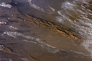
. The patchy, elongated, light-colored feature in the foreground (parallel to the mountain range) is the northernmost of the Dasht dry lakes that stretch southward 300 kilometres (186.4 mi). In near-tropical deserts, elevated areas capture most precipitation. As a result, the Dasht-e Lut is generally considered to be an abiotic zone.
Iran's geography
Geography of Iran
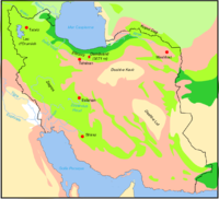
Iran is located in southwest Asia and borders the Gulf of Oman, Persian Gulf, and Caspian Sea.Its mountains have helped to shape both the political and the economic history of the country for several centuries. The mountains enclose several broad basins, or plateaus, on which major agricultural and...
consists of a plateau
Plateau
In geology and earth science, a plateau , also called a high plain or tableland, is an area of highland, usually consisting of relatively flat terrain. A highly eroded plateau is called a dissected plateau...
surrounded by mountains and divided into drainage basins. Dasht-e Lut is one of the largest of these desert basins, 480 kilometres (298.3 mi) long and 320 kilometres (198.8 mi) wide, and is considered to be one of the driest places on Earth.
Area of the desert is about 51,800 square kilometers (20,000 mi²). The other large basin is the Dasht-e Kavir
Dasht-e Kavir
Dasht-e Kavir , also known as Kavir-e Namak or Great Salt Desert is a large desert lying in the middle of the Iranian plateau. It is about 800 kilometers long and 320 kilometers wide with a total surface area of about 77,600 square kilometers , making it the Earth's 23rd largest desert...
. During the spring wet season, water briefly flows down from the Kerman mountains
Hazaran
Hazaran is the name of a massif of the Central Iranian Plateau, Kerman province, Iran, an eastern outlier of the Zagros mountains. The Jebal Barez chain is a continuation to the south-east....
, but it soon dries up, leaving behind only rocks, sand, and salt.
The eastern part of Dasht-e Lut is a low plateau covered with salt flats. In contrast, the center has been sculpted by the wind into a series of parallel ridges and furrows, extending over 150 km (93.2 mi) and reaching 75 m (250 ft) in height. This area is also riddled with ravine
Ravine
A ravine is a landform narrower than a canyon and is often the product of streamcutting erosion. Ravines are typically classified as larger in scale than gullies, although smaller than valleys. A ravine is generally a fluvial slope landform of relatively steep sides, on the order of twenty to...
s and sinkhole
Sinkhole
A sinkhole, also known as a sink, shake hole, swallow hole, swallet, doline or cenote, is a natural depression or hole in the Earth's surface caused by karst processes — the chemical dissolution of carbonate rocks or suffosion processes for example in sandstone...
s. The southeast is a vast expanse of sand, like a Saharan erg
Erg (landform)
An erg is a broad, flat area of desert covered with wind-swept sand with little or no vegetative cover. The term takes its name from the Arabic word ʿarq , meaning "dune field"...
, with dune
Dune
In physical geography, a dune is a hill of sand built by wind. Dunes occur in different forms and sizes, formed by interaction with the wind. Most kinds of dunes are longer on the windward side where the sand is pushed up the dune and have a shorter "slip face" in the lee of the wind...
s 300 m (1000 ft) high, among the tallest in the world.
Hottest land surface
Measurements of MODIS (Moderate-Resolution Imaging Spectroradiometer) installed on NASANASA
The National Aeronautics and Space Administration is the agency of the United States government that is responsible for the nation's civilian space program and for aeronautics and aerospace research...
's satellite "Aqua
Aqua (satellite)
Aqua is a multi-national NASA scientific research satellite in orbit around the Earth, studying the precipitation, evaporation, and cycling of water. It is the second major component of the Earth Observing System preceded by Terra and followed by Aura .The name "Aqua" comes from the Latin word...
" from 2003 - 2005 testify that the hottest land surface on Earth is located in Dasht-e Lut and land surface temperatures reach here 70.7 degrees C (159 degrees F). Precision of measurements is 0.5 - 1 degrees K.
The hottest part of Dasht-e Lut is Gandom Beryan - approximately 480 km² large plateau covered with dark lava. According to local legend this name (in translation from Persian
Persian language
Persian is an Iranian language within the Indo-Iranian branch of the Indo-European languages. It is primarily spoken in Iran, Afghanistan, Tajikistan and countries which historically came under Persian influence...
- "Toasted wheat") originates from an accident where load of wheat left in the desert was scorched by the heat in a few days time.