
Cyclone Elita
Encyclopedia
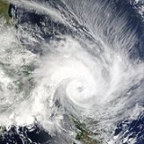
Cyclone Elita was an unusual tropical cyclone
that made landfall
on Madagascar
three times. The fifth named storm of the 2003–04 South-West Indian Ocean cyclone season
, Elita developed on January 24 in the Mozambique Channel
. It strengthened to become a tropical cyclone
before striking northwestern Madagascar on January 28. Elita weakened to tropical depression status while crossing the island, and after exiting into the southwest Indian Ocean
it turned to the west and moved ashore for a second time on January 31 in eastern Madagascar. After crossing the island, the cyclone intensified again after reaching the Mozambique Channel, and Elita turned to the southeast to make its final landfall on February 3 along southwestern Madagascar. By February 5 it underwent extratropical transition
, and the remnants of Elita moved erratically before dissipating on February 13.
Elita dropped heavy rainfall of over 200 mm (8 inches), which damaged or destroyed thousands of houses in Madagascar. Over 50,000 people were left homeless, primarily in Mahajanga
and Toliara
provinces. Flooding from the storm damaged or destroyed more than 450 km² (170 sq mi) of agricultural land, including important crops for food. Across the island, the cyclone caused at least 33 deaths, with its impact further compounded by Cyclone Gafilo
about two months later. Elsewhere, the cyclone brought rainfall and damage to Mozambique
and Malawi
, while its outer circulation produced rough seas and strong winds in Seychelles
, Mauritius
, and Réunion
.
on January 25, 2004, about 95 km (60 mi) west of Madagascar
. Deep convection
developed and organized around a mid- to low-level circulation, and at 0600 UTC
on January 26, Météo-France
(MFR) classified the system as Tropical Disturbance 06, about 105 km (65 mi) west of Maintirano
, Madagascar. Six hours later, it was upgraded to Tropical Depression 06, and later that day the depression was named Elita. At the same time, the Joint Typhoon Warning Center
(JTWC) began issuing advisories on the cyclone. Strengthening at first was slow, due to moderate wind shear limiting the convection to the northern portion of the cyclone. Initially, the storm tracked in an unusual northward motion toward the equator, which was caused by a ridge
to its west.
Early on January 27, Elita was upgraded to a moderate tropical storm, though later that day it weakened to tropical depression status. However, it quickly re-attained tropical storm status early on January 28, with convection increasing further. Elita turned east-southeastward due to a ridge to its north, quickly intensifying as it approached land and developing a well-defined eye
on visible satellite imagery. It intensified to tropical cyclone
status, or the equivalence of a minimal hurricane, at 1200 UTC on January 28. Three hours later, Elita made landfall
on Bombetoka Bay
in northwestern Madagascar with wind gusts of over 180 km/h (110 mph). The storm rapidly weakened to tropical depression status over land, though as it crossed the island convection re-developed over the waters east of Madagascar. Elita reached the southwest Indian Ocean by January 30, and its convection quickly organized into rainbands. It drifted southward a short distance offshore, slowly intensifying before attaining tropical storm status at 0000 UTC on January 31. About six hours later, after turning to the west, Elita moved ashore near Mananjary
with winds of about 75 km/h (45 mph), as reported by MFR.
The cyclone quickly weakened to tropical depression status as it tracked westward across Madagascar, and late on January 31 it emerged into the Mozambique Channel. Deep convection increased as it reached open waters, with outflow
improving. A strengthening ridge to its north caused Elita to decelerate before turning to the east-southeast. Late on February 2, the JTWC assessed Elita with peak winds of 120 km/h (75 km/h), and shortly thereafter MFR reported the cyclone as attaining peak winds of 110 km/h (70 mph). Early on February 3, Elita moved ashore near Morondava
at peak intensity. Weakening rapidly while crossing the island for a third time, the cyclone emerged into the southwest Indian Ocean as a tropical depression by 0000 UTC on February 4. Despite initial forecasts of re-intensification, Elita accelerated southeastward and lost its remaining convection, leaving its center exposed under the influence of a strong upper-level trough
. By February 5, it had transitioned into an extratropical cyclone
, and its motion had halted due to weak steering currents. For about a week, the remnants of Elita meandered to the southeast of Madagascar before dissipating on February 13.
Elita's crossing of Madagascar three times is unusual, but not unprecedented; Cyclone Felicie in January 1970 and Storm Justine in March 1982 accomplished the same feat.
_rain_density.jpg) The Mozambique National Institute of Meteorology
The Mozambique National Institute of Meteorology
advised people living in Nampula
, Zambezia
, Sofala
, and Inhambane Province
s to make preparations for strong winds and rainfall. In Nampula province, over 2000 buildings were destroyed. The most severe damage was to generally poorly built houses in Memba
, Nacala-a-Velha, Mogincual, and Nampula city
. In the latter city, an Islamic school was badly damaged, and in Nacla-a-Velha survivors had to spend the night of January 29 in the open. All in all, Elita impacted four provinces of Mozambique
. Much of the impact was along the coast from Inhambane
to Nampula. The inflow of the storm brought moisture from the Intertropical Convergence Zone
through Malawi
, which produced heavy rainfall of over 150 mm (6 in); the rainfall destroyed more than 80 houses and a clinic in Karonga district
. The storm brought rough seas, gusty winds, and some precipitation to the southwestern islands in Seychelles
.
Upon making its first landfall on Madagascar
, Elita dropped heavy rainfall along its path, peaking at 715 mm (28.1 in) including a 24 hour total of 222 mm (8.74 in) in Antsohihy
. Wind gusts reached over 180 km/h (110 mph) in Mahajanga
. The passage of the cyclone left 5,000 people homeless in the vicinity of its first landfall, with 90 percent of the buildings in northwestern Mahajanga Province
damaged by the storm. At least two people were killed in the region. Throughout the country, Cyclone Elita destroyed or severely damaged 12,408 homes, which left 55,983 people homeless, primarily in Mahajanga and Toliara
. This forced around 7,000 people to seek shelter in either stadiums or in the remaining standing buildings. Additionally, a total of 510 schools and hospitals received major damage. The cyclone affected five of the six provinces of Madagascar, with roads and power being severely disrupted in some areas; at least 39 bridges were damaged or destroyed. The cities of Maintirano
and Soavinandriana
were both severely damaged. In Midongy Atismo
, heavy rainfall flooded 80% of the town's rice crop,
and the corn and manioc crops were both similarly affected. These represent the staple foods of the population, and across the nation the storm damaged more than 450 km² (173.7 sq mi) of agricultural land. Throughout Madagascar, the cyclone killed at least 33 people and injured 129 others.
The extratropical remnants of Elita produced rough seas and strong winds on Mauritius
and Réunion
island, which caused one ship to sink.
 On February 13, 2004, officials in Madagascar issued an appeal for international aid. By a month after the storm, the governments of France
, United States
, Germany
, and Japan
sent a total of $287,000 (2004 USD) in assistance. The government of France
sent a plane with food, medicine, and other equipment to the affected areas. The government of Germany
sent aid to be used for foods and medicines. On February 27, the government of Japan
sent aid to the country, including tents, generators, and plastic sheets.
Officials distributed emergency relief items to the impacted areas, including rice, sugar, soap, candles, matches and water purification tablets. In Morondava
in Toliara Province
, the government distributed 4 tons of rice seed, while in Ambatolampy in Antananarivo Province
, the government sent 10 tons of rice; additionally, the World Food Programme
sent 80 tons of flour to the nation. The combined efforts of the United Nations
and aid agencies repaired the schools and distributed meals to the families affected by the disaster. Workers in association with the Madagascar Red Cross
set up a water system that provided about 45,000 litres (11,900 gallons) of drinkable water per day.
The impact of Cyclone Elita was severely compounded by Cyclone Gafilo
about two months later, which killed hundreds and left over 240,000 people homeless.
Tropical cyclone
A tropical cyclone is a storm system characterized by a large low-pressure center and numerous thunderstorms that produce strong winds and heavy rain. Tropical cyclones strengthen when water evaporated from the ocean is released as the saturated air rises, resulting in condensation of water vapor...
that made landfall
Landfall (meteorology)
Landfall is the event of a tropical cyclone or a waterspout coming onto land after being over water. When a waterspout makes landfall it is reclassified as a tornado, which can then cause damage inland...
on Madagascar
Madagascar
The Republic of Madagascar is an island country located in the Indian Ocean off the southeastern coast of Africa...
three times. The fifth named storm of the 2003–04 South-West Indian Ocean cyclone season
2003-04 South-West Indian Ocean cyclone season
The 2003-04 South-West Indian Ocean cyclone season was an annual event of tropical cyclone formation. It started on November 15, 2003 and ended on April 30, 2004. For Mauritius and the Seychelles, the season continued until May 15. These dates conventionally delimit the period of each year when...
, Elita developed on January 24 in the Mozambique Channel
Mozambique Channel
The Mozambique Channel is a portion of the Indian Ocean located between the island nation of Madagascar and southeast Africa, primarily the country of Mozambique. It was a World War II clashpoint during the Battle of Madagascar...
. It strengthened to become a tropical cyclone
Tropical cyclone scales
Tropical systems are officially ranked on one of several tropical cyclone scales according to their maximum sustained winds and in what oceanic basin they are located...
before striking northwestern Madagascar on January 28. Elita weakened to tropical depression status while crossing the island, and after exiting into the southwest Indian Ocean
Indian Ocean
The Indian Ocean is the third largest of the world's oceanic divisions, covering approximately 20% of the water on the Earth's surface. It is bounded on the north by the Indian Subcontinent and Arabian Peninsula ; on the west by eastern Africa; on the east by Indochina, the Sunda Islands, and...
it turned to the west and moved ashore for a second time on January 31 in eastern Madagascar. After crossing the island, the cyclone intensified again after reaching the Mozambique Channel, and Elita turned to the southeast to make its final landfall on February 3 along southwestern Madagascar. By February 5 it underwent extratropical transition
Extratropical cyclone
Extratropical cyclones, sometimes called mid-latitude cyclones or wave cyclones, are a group of cyclones defined as synoptic scale low pressure weather systems that occur in the middle latitudes of the Earth having neither tropical nor polar characteristics, and are connected with fronts and...
, and the remnants of Elita moved erratically before dissipating on February 13.
Elita dropped heavy rainfall of over 200 mm (8 inches), which damaged or destroyed thousands of houses in Madagascar. Over 50,000 people were left homeless, primarily in Mahajanga
Mahajanga Province
Mahajanga is a former province of Madagascar with an area of 150,023 km². It had a population of 1,896,000 . Its capital was Mahajanga.Except for Fianarantsoa, Mahajanga Province bordered all of the country's other provinces:...
and Toliara
Toliara Province
Toliara is a former province of Madagascar with an area of 161,405 km². It had a population of 2,229,550 . Its capital was Toliara...
provinces. Flooding from the storm damaged or destroyed more than 450 km² (170 sq mi) of agricultural land, including important crops for food. Across the island, the cyclone caused at least 33 deaths, with its impact further compounded by Cyclone Gafilo
Cyclone Gafilo
Cyclone Gafilo was a powerful tropical cyclone which struck Madagascar in March 2004, causing devastating damage. It is the most intense cyclone ever to form in the south-western Indian Ocean.-Meteorological history:...
about two months later. Elsewhere, the cyclone brought rainfall and damage to Mozambique
Mozambique
Mozambique, officially the Republic of Mozambique , is a country in southeastern Africa bordered by the Indian Ocean to the east, Tanzania to the north, Malawi and Zambia to the northwest, Zimbabwe to the west and Swaziland and South Africa to the southwest...
and Malawi
Malawi
The Republic of Malawi is a landlocked country in southeast Africa that was formerly known as Nyasaland. It is bordered by Zambia to the northwest, Tanzania to the northeast, and Mozambique on the east, south and west. The country is separated from Tanzania and Mozambique by Lake Malawi. Its size...
, while its outer circulation produced rough seas and strong winds in Seychelles
Seychelles
Seychelles , officially the Republic of Seychelles , is an island country spanning an archipelago of 115 islands in the Indian Ocean, some east of mainland Africa, northeast of the island of Madagascar....
, Mauritius
Mauritius
Mauritius , officially the Republic of Mauritius is an island nation off the southeast coast of the African continent in the southwest Indian Ocean, about east of Madagascar...
, and Réunion
Réunion
Réunion is a French island with a population of about 800,000 located in the Indian Ocean, east of Madagascar, about south west of Mauritius, the nearest island.Administratively, Réunion is one of the overseas departments of France...
.
Meteorological history
An area of thunderstorms developed in the Mozambique ChannelMozambique Channel
The Mozambique Channel is a portion of the Indian Ocean located between the island nation of Madagascar and southeast Africa, primarily the country of Mozambique. It was a World War II clashpoint during the Battle of Madagascar...
on January 25, 2004, about 95 km (60 mi) west of Madagascar
Madagascar
The Republic of Madagascar is an island country located in the Indian Ocean off the southeastern coast of Africa...
. Deep convection
Convection
Convection is the movement of molecules within fluids and rheids. It cannot take place in solids, since neither bulk current flows nor significant diffusion can take place in solids....
developed and organized around a mid- to low-level circulation, and at 0600 UTC
Coordinated Universal Time
Coordinated Universal Time is the primary time standard by which the world regulates clocks and time. It is one of several closely related successors to Greenwich Mean Time. Computer servers, online services and other entities that rely on having a universally accepted time use UTC for that purpose...
on January 26, Météo-France
Météo-France
Météo-France is the French national meteorological service.The organisation was established by decree in June 1993 and is a department of the Ministry of Transportation. It is headquartered in Paris but many domestic operations have been decentralised to Toulouse...
(MFR) classified the system as Tropical Disturbance 06, about 105 km (65 mi) west of Maintirano
Maintirano
Maintirano is a coastal city and commune in western Madagascar approximately 325 kilometres west of the capital Antananarivo. It belongs to the district of Maintirano, which is a part of Melaky Region – Maintirano is capital of Melaky region. The population of the commune was estimated to be...
, Madagascar. Six hours later, it was upgraded to Tropical Depression 06, and later that day the depression was named Elita. At the same time, the Joint Typhoon Warning Center
Joint Typhoon Warning Center
The Joint Typhoon Warning Center is a joint United States Navy – United States Air Force task force located at the Naval Maritime Forecast Center in Pearl Harbor, Hawaii...
(JTWC) began issuing advisories on the cyclone. Strengthening at first was slow, due to moderate wind shear limiting the convection to the northern portion of the cyclone. Initially, the storm tracked in an unusual northward motion toward the equator, which was caused by a ridge
Ridge (meteorology)
A ridge is an elongated region of relatively high atmospheric pressure, the opposite of a trough....
to its west.
Early on January 27, Elita was upgraded to a moderate tropical storm, though later that day it weakened to tropical depression status. However, it quickly re-attained tropical storm status early on January 28, with convection increasing further. Elita turned east-southeastward due to a ridge to its north, quickly intensifying as it approached land and developing a well-defined eye
Eye (cyclone)
The eye is a region of mostly calm weather found at the center of strong tropical cyclones. The eye of a storm is a roughly circular area and typically 30–65 km in diameter. It is surrounded by the eyewall, a ring of towering thunderstorms where the second most severe weather of a cyclone...
on visible satellite imagery. It intensified to tropical cyclone
Tropical cyclone scales
Tropical systems are officially ranked on one of several tropical cyclone scales according to their maximum sustained winds and in what oceanic basin they are located...
status, or the equivalence of a minimal hurricane, at 1200 UTC on January 28. Three hours later, Elita made landfall
Landfall (meteorology)
Landfall is the event of a tropical cyclone or a waterspout coming onto land after being over water. When a waterspout makes landfall it is reclassified as a tornado, which can then cause damage inland...
on Bombetoka Bay
Bombetoka Bay
Bombetoka Bay is a bay on the northwestern coast of Madagascar near the city of Mahajanga, where the Betsiboka River flows into the Mozambique Channel...
in northwestern Madagascar with wind gusts of over 180 km/h (110 mph). The storm rapidly weakened to tropical depression status over land, though as it crossed the island convection re-developed over the waters east of Madagascar. Elita reached the southwest Indian Ocean by January 30, and its convection quickly organized into rainbands. It drifted southward a short distance offshore, slowly intensifying before attaining tropical storm status at 0000 UTC on January 31. About six hours later, after turning to the west, Elita moved ashore near Mananjary
Mananjary, Fianarantsoa
Mananjary is a fivondronana located in Vatovavy-Fitovinany Region in Madagascar. The region has a total population of 233,697 ....
with winds of about 75 km/h (45 mph), as reported by MFR.
The cyclone quickly weakened to tropical depression status as it tracked westward across Madagascar, and late on January 31 it emerged into the Mozambique Channel. Deep convection increased as it reached open waters, with outflow
Outflow (meteorology)
Outflow, in meteorology, is air that flows outwards from a storm system. It is associated with ridging, or anticyclonic flow. In the low levels of the troposphere, outflow radiates from thunderstorms in the form of a wedge of rain-cooled air, which is visible as a thin rope-like cloud on weather...
improving. A strengthening ridge to its north caused Elita to decelerate before turning to the east-southeast. Late on February 2, the JTWC assessed Elita with peak winds of 120 km/h (75 km/h), and shortly thereafter MFR reported the cyclone as attaining peak winds of 110 km/h (70 mph). Early on February 3, Elita moved ashore near Morondava
Morondava
Morondava is a city located in Menabe Region, of which it is the capital, in Madagascar. It is located in the delta of the Morandava River at .-Communication:...
at peak intensity. Weakening rapidly while crossing the island for a third time, the cyclone emerged into the southwest Indian Ocean as a tropical depression by 0000 UTC on February 4. Despite initial forecasts of re-intensification, Elita accelerated southeastward and lost its remaining convection, leaving its center exposed under the influence of a strong upper-level trough
Trough (meteorology)
A trough is an elongated region of relatively low atmospheric pressure, often associated with fronts.Unlike fronts, there is not a universal symbol for a trough on a weather chart. The weather charts in some countries or regions mark troughs by a line. In the United States, a trough may be marked...
. By February 5, it had transitioned into an extratropical cyclone
Extratropical cyclone
Extratropical cyclones, sometimes called mid-latitude cyclones or wave cyclones, are a group of cyclones defined as synoptic scale low pressure weather systems that occur in the middle latitudes of the Earth having neither tropical nor polar characteristics, and are connected with fronts and...
, and its motion had halted due to weak steering currents. For about a week, the remnants of Elita meandered to the southeast of Madagascar before dissipating on February 13.
Elita's crossing of Madagascar three times is unusual, but not unprecedented; Cyclone Felicie in January 1970 and Storm Justine in March 1982 accomplished the same feat.
Impact
Mozambique National Institute of Meteorology
The Mozambique National Institute of Meteorology or the Instituto Nacional de Meteorologia de Moçambique in Portuguese, is the national meteorological institute of Mozambique....
advised people living in Nampula
Nampula Province
Nampula is a province of Mozambique. It has an area of 81,606 km² and a population of 3.985.285 . Nampula is the capital of the province...
, Zambezia
Zambezia Province
Zambezia is the most-populous province of Mozambique, located in the central coastal region south-west of Nampula Province and north-east of Sofala Province. It has a population of 3,794,509 . The provincial capital is Quelimane on the Bons Sinais River.Zambezia has a total area of...
, Sofala
Sofala Province
Sofala is a province of Mozambique. It has an area of 68,018 km² and a population of 1.676.131 . Beira is the capital of the province. The province is named for the ruined port of Sofala.- Districts :Districts of Sofala Province include:...
, and Inhambane Province
Inhambane Province
Inhambane is a province of Mozambique located on the coast in the southern part of the country. It has an area of 68,615 km² and a population of 1.412.349 . The provincial capital is also called Inhambane....
s to make preparations for strong winds and rainfall. In Nampula province, over 2000 buildings were destroyed. The most severe damage was to generally poorly built houses in Memba
Memba
The Memba are a tribal population of 3,500 is centered around Tuting and Geling, near the Siang river in the West Siang and Upper Siang district of Arunachal Pradesh in India not very far from the Tibetan border. A sizeable population can be found in the nearby Yargab-Chu valley in Mechuka , where...
, Nacala-a-Velha, Mogincual, and Nampula city
Nampula
Nampula is the capital city of Nampula Province in Mozambique.It has a population of 471,717 making it the third largest city in Mozambique after Maputo and Beira. It is home to the Mozambique National Ethnographic Museum, several markets, cathedrals and mosques.It is also the center of business...
. In the latter city, an Islamic school was badly damaged, and in Nacla-a-Velha survivors had to spend the night of January 29 in the open. All in all, Elita impacted four provinces of Mozambique
Provinces of Mozambique
||Mozambique is divided into 10 provinces and 1 capital city with provincial status:#Cabo Delgado Province#Gaza Province#Inhambane Province#Manica Province#Maputo City#Maputo Province#Nampula Province#Niassa Province...
. Much of the impact was along the coast from Inhambane
Inhambane
Inhambane, Terra de Boa Gente is a city located in southern Mozambique, lying on Inhambane Bay, 470 km northeast of Maputo. It is the capital of the Inhambane Province and according to the 2008 census has a population of 65,837, growing from the 1997 census of 54,157...
to Nampula. The inflow of the storm brought moisture from the Intertropical Convergence Zone
Intertropical Convergence Zone
The Intertropical Convergence Zone , known by sailors as The Doldrums, is the area encircling the earth near the equator where winds originating in the northern and southern hemispheres come together....
through Malawi
Malawi
The Republic of Malawi is a landlocked country in southeast Africa that was formerly known as Nyasaland. It is bordered by Zambia to the northwest, Tanzania to the northeast, and Mozambique on the east, south and west. The country is separated from Tanzania and Mozambique by Lake Malawi. Its size...
, which produced heavy rainfall of over 150 mm (6 in); the rainfall destroyed more than 80 houses and a clinic in Karonga district
Karonga
Karonga is a township in the Karonga District in Northern Region of Malawi. Located on the western shore of Lake Nyasa, it was established as a slaving centre sometime before 1877. As of 2008 estimates, Karonga has a population of 42,555.-History:...
. The storm brought rough seas, gusty winds, and some precipitation to the southwestern islands in Seychelles
Seychelles
Seychelles , officially the Republic of Seychelles , is an island country spanning an archipelago of 115 islands in the Indian Ocean, some east of mainland Africa, northeast of the island of Madagascar....
.
Upon making its first landfall on Madagascar
Madagascar
The Republic of Madagascar is an island country located in the Indian Ocean off the southeastern coast of Africa...
, Elita dropped heavy rainfall along its path, peaking at 715 mm (28.1 in) including a 24 hour total of 222 mm (8.74 in) in Antsohihy
Antsohihy
Antsohihy is a city in northern Madagascar in Sofia Region.Antsohihy is the capital of Sofia Region and of Antsohihy District....
. Wind gusts reached over 180 km/h (110 mph) in Mahajanga
Mahajanga
Mahajanga is a city and a district on the north-west coast of Madagascar.- City :The City of Mahajanga is the capital of the Boeny region. Population: 135,660 ....
. The passage of the cyclone left 5,000 people homeless in the vicinity of its first landfall, with 90 percent of the buildings in northwestern Mahajanga Province
Mahajanga Province
Mahajanga is a former province of Madagascar with an area of 150,023 km². It had a population of 1,896,000 . Its capital was Mahajanga.Except for Fianarantsoa, Mahajanga Province bordered all of the country's other provinces:...
damaged by the storm. At least two people were killed in the region. Throughout the country, Cyclone Elita destroyed or severely damaged 12,408 homes, which left 55,983 people homeless, primarily in Mahajanga and Toliara
Toliara Province
Toliara is a former province of Madagascar with an area of 161,405 km². It had a population of 2,229,550 . Its capital was Toliara...
. This forced around 7,000 people to seek shelter in either stadiums or in the remaining standing buildings. Additionally, a total of 510 schools and hospitals received major damage. The cyclone affected five of the six provinces of Madagascar, with roads and power being severely disrupted in some areas; at least 39 bridges were damaged or destroyed. The cities of Maintirano
Maintirano
Maintirano is a coastal city and commune in western Madagascar approximately 325 kilometres west of the capital Antananarivo. It belongs to the district of Maintirano, which is a part of Melaky Region – Maintirano is capital of Melaky region. The population of the commune was estimated to be...
and Soavinandriana
Soavinandriana
Soavinandriana is a town in Itasy Region, Madagascar....
were both severely damaged. In Midongy Atismo
Midongy Atismo
Midongy Atismo is a town in the hills of southern Fianarantsoa Province in southern Madagascar....
, heavy rainfall flooded 80% of the town's rice crop,
and the corn and manioc crops were both similarly affected. These represent the staple foods of the population, and across the nation the storm damaged more than 450 km² (173.7 sq mi) of agricultural land. Throughout Madagascar, the cyclone killed at least 33 people and injured 129 others.
The extratropical remnants of Elita produced rough seas and strong winds on Mauritius
Mauritius
Mauritius , officially the Republic of Mauritius is an island nation off the southeast coast of the African continent in the southwest Indian Ocean, about east of Madagascar...
and Réunion
Réunion
Réunion is a French island with a population of about 800,000 located in the Indian Ocean, east of Madagascar, about south west of Mauritius, the nearest island.Administratively, Réunion is one of the overseas departments of France...
island, which caused one ship to sink.
Aftermath
France
The French Republic , The French Republic , The French Republic , (commonly known as France , is a unitary semi-presidential republic in Western Europe with several overseas territories and islands located on other continents and in the Indian, Pacific, and Atlantic oceans. Metropolitan France...
, United States
United States
The United States of America is a federal constitutional republic comprising fifty states and a federal district...
, Germany
Germany
Germany , officially the Federal Republic of Germany , is a federal parliamentary republic in Europe. The country consists of 16 states while the capital and largest city is Berlin. Germany covers an area of 357,021 km2 and has a largely temperate seasonal climate...
, and Japan
Japan
Japan is an island nation in East Asia. Located in the Pacific Ocean, it lies to the east of the Sea of Japan, China, North Korea, South Korea and Russia, stretching from the Sea of Okhotsk in the north to the East China Sea and Taiwan in the south...
sent a total of $287,000 (2004 USD) in assistance. The government of France
France
The French Republic , The French Republic , The French Republic , (commonly known as France , is a unitary semi-presidential republic in Western Europe with several overseas territories and islands located on other continents and in the Indian, Pacific, and Atlantic oceans. Metropolitan France...
sent a plane with food, medicine, and other equipment to the affected areas. The government of Germany
Germany
Germany , officially the Federal Republic of Germany , is a federal parliamentary republic in Europe. The country consists of 16 states while the capital and largest city is Berlin. Germany covers an area of 357,021 km2 and has a largely temperate seasonal climate...
sent aid to be used for foods and medicines. On February 27, the government of Japan
Japan
Japan is an island nation in East Asia. Located in the Pacific Ocean, it lies to the east of the Sea of Japan, China, North Korea, South Korea and Russia, stretching from the Sea of Okhotsk in the north to the East China Sea and Taiwan in the south...
sent aid to the country, including tents, generators, and plastic sheets.
Officials distributed emergency relief items to the impacted areas, including rice, sugar, soap, candles, matches and water purification tablets. In Morondava
Morondava
Morondava is a city located in Menabe Region, of which it is the capital, in Madagascar. It is located in the delta of the Morandava River at .-Communication:...
in Toliara Province
Toliara Province
Toliara is a former province of Madagascar with an area of 161,405 km². It had a population of 2,229,550 . Its capital was Toliara...
, the government distributed 4 tons of rice seed, while in Ambatolampy in Antananarivo Province
Antananarivo Province
Antananarivo is a former province of Madagascar with an area of 58,283 km². It had a population of 5,370,900 . Its capital was Antananarivo.Except for Antsiranana, Antananarivo Province bordered all of the country's other provinces:*Mahajanga - north...
, the government sent 10 tons of rice; additionally, the World Food Programme
World Food Programme
The World Food Programme is the food aid branch of the United Nations, and the world's largest humanitarian organization addressing hunger worldwide. WFP provides food, on average, to 90 million people per year, 58 million of whom are children...
sent 80 tons of flour to the nation. The combined efforts of the United Nations
United Nations
The United Nations is an international organization whose stated aims are facilitating cooperation in international law, international security, economic development, social progress, human rights, and achievement of world peace...
and aid agencies repaired the schools and distributed meals to the families affected by the disaster. Workers in association with the Madagascar Red Cross
International Red Cross and Red Crescent Movement
The International Red Cross and Red Crescent Movement is an international humanitarian movement with approximately 97 million volunteers, members and staff worldwide which was founded to protect human life and health, to ensure respect for all human beings, and to prevent and alleviate human...
set up a water system that provided about 45,000 litres (11,900 gallons) of drinkable water per day.
The impact of Cyclone Elita was severely compounded by Cyclone Gafilo
Cyclone Gafilo
Cyclone Gafilo was a powerful tropical cyclone which struck Madagascar in March 2004, causing devastating damage. It is the most intense cyclone ever to form in the south-western Indian Ocean.-Meteorological history:...
about two months later, which killed hundreds and left over 240,000 people homeless.
See also
- Geography of MadagascarGeography of MadagascarMadagascar is an island in the Indian Ocean off the eastern coast of southern Africa, east of Mozambique. It is the fourth largest island in the world. The highest point is Maromokotro, in the Tsaratanana Massif region in the north of the island, at . The capital Antananarivo is in the Hauts...
- List of wettest tropical cyclones in Madagascar