
Geography of Madagascar
Overview
Madagascar
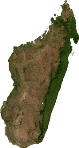
The Republic of Madagascar is an island country located in the Indian Ocean off the southeastern coast of Africa...
is an island in the Indian Ocean
Indian Ocean
The Indian Ocean is the third largest of the world's oceanic divisions, covering approximately 20% of the water on the Earth's surface. It is bounded on the north by the Indian Subcontinent and Arabian Peninsula ; on the west by eastern Africa; on the east by Indochina, the Sunda Islands, and...
off the eastern coast of southern Africa
Africa
Africa is the world's second largest and second most populous continent, after Asia. At about 30.2 million km² including adjacent islands, it covers 6% of the Earth's total surface area and 20.4% of the total land area...
, east of Mozambique
Mozambique
Mozambique, officially the Republic of Mozambique , is a country in southeastern Africa bordered by the Indian Ocean to the east, Tanzania to the north, Malawi and Zambia to the northwest, Zimbabwe to the west and Swaziland and South Africa to the southwest...
. It is the fourth largest island in the world. The highest point is Maromokotro
Maromokotro
Maromokotro is the highest mountain on Madagascar at high. It is located in the Tsaratanana Massif in the northern part of the island.-External links:* Picture of Maromokotro...
, in the Tsaratanana
Tsaratanana
Tsaratanana is a town and commune in Madagascar. It belongs to the district of Tsaratanana, which is a part of Betsiboka Region. The population of the commune was estimated to be approximately 18,000 in 2001 commune census....
Massif region in the north of the island, at 2876 metres (9,435.7 ft). The capital Antananarivo
Antananarivo
Antananarivo , formerly Tananarive , is the capital and largest city in Madagascar. It is also known by its French colonial shorthand form Tana....
is in the Hauts Plateaux near the centre of the island. It has a total area of 587040 square kilometres (226,657.4 sq mi) with 581540 square kilometres (224,533.8 sq mi) of land and 5500 square kilometres (2,123.6 sq mi) of water.
Madagascar originated as part of the Gondwana
Gondwana
In paleogeography, Gondwana , originally Gondwanaland, was the southernmost of two supercontinents that later became parts of the Pangaea supercontinent. It existed from approximately 510 to 180 million years ago . Gondwana is believed to have sutured between ca. 570 and 510 Mya,...
supercontinent.