

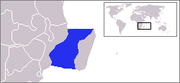
Mozambique Channel
Encyclopedia
Indian Ocean
The Indian Ocean is the third largest of the world's oceanic divisions, covering approximately 20% of the water on the Earth's surface. It is bounded on the north by the Indian Subcontinent and Arabian Peninsula ; on the west by eastern Africa; on the east by Indochina, the Sunda Islands, and...
located between the island nation of Madagascar
Madagascar
The Republic of Madagascar is an island country located in the Indian Ocean off the southeastern coast of Africa...
and southeast Africa
Africa
Africa is the world's second largest and second most populous continent, after Asia. At about 30.2 million km² including adjacent islands, it covers 6% of the Earth's total surface area and 20.4% of the total land area...
, primarily the country of Mozambique
Mozambique
Mozambique, officially the Republic of Mozambique , is a country in southeastern Africa bordered by the Indian Ocean to the east, Tanzania to the north, Malawi and Zambia to the northwest, Zimbabwe to the west and Swaziland and South Africa to the southwest...
. It was a World War II
World War II
World War II, or the Second World War , was a global conflict lasting from 1939 to 1945, involving most of the world's nations—including all of the great powers—eventually forming two opposing military alliances: the Allies and the Axis...
clashpoint during the Battle of Madagascar
Battle of Madagascar
The Battle of Madagascar was the Allied campaign to capture Vichy-French-controlled Madagascar during World War II. It began on 5 May 1942. Fighting did not cease until 6 November.-Geo-political:...
. The channel is approximately 460 kilometers across at its narrowest point between Angoche
Angoche
Angoche is a city of Nampula Province in Mozambique. The city was named António Enes until 1976, after the 19th century Portuguese journalist and colonial administrator, António José Enes...
, Mozambique, and Tambohorano
Tambohorano
Tambohorano is a town and commune on the west coast of Madagascar approximately 290 kilometres north-west of the capital Antananarivo.. It belongs to the district of Maintirano, which is a part of Melaky Region. The population of the commune was estimated to be approximately 8,000 in 2001 commune...
, Madagascar.
The channel reaches a depth of 3,292 meters (10,800 feet) about 230 kilometers off the coast of Mozambique. A warm current flows in a southward direction in the channel, leading into the Agulhas Current
Agulhas Current
The Agulhas Current is the Western Boundary Current of the southwest Indian Ocean. It flows down the east coast of Africa from 27°S to 40°S. It is narrow, swift and strong...
off the east coast of South Africa
South Africa
The Republic of South Africa is a country in southern Africa. Located at the southern tip of Africa, it is divided into nine provinces, with of coastline on the Atlantic and Indian oceans...
. It is around 1000 miles (1600 kilometers) long and the width of it varies from 250-600 miles (400-950 kilometers).
Extent
The International Hydrographic OrganizationInternational Hydrographic Organization
The International Hydrographic Organization is the inter-governmental organisation representing the hydrographic community. It enjoys observer status at the UN and is the recognised competent authority on hydrographic surveying and nautical charting...
defines the limits of the Mozambique Channel as follows:
On the North. A line from the estuary of the River RovumaRuvuma RiverRuvuma River, formerly also known as the Rovuma River, is a river in East Africa, forming during the greater part of its course the border between Tanzania and Mozambique . It is long, with a drainage basin in size...
(10°28′S 40°26′E) to Ras Habu, the Northern point of Ile Grande ComoreGrande ComoreGrande Comore is an island in the Indian Ocean off the coast of Africa. It is the largest island in the Comoros nation. Most of its population is of the Comorian ethnic group. Its population as of 2006 is about 316,600. The island's capital is Moroni, which is also the national capital...
, the Northern of the Comore (Comoro) IslandsComoro IslandsThe Comoros Islands form an archipelago of volcanic islands situated off the south-east coast of Africa, to the east of Mozambique and north-west of Madagascar. They are divided between the sovereign state of Comoros and the French overseas department of Mayotte...
, to Cap d'Ambre (Amber) the Northern extremity of MadagascarMadagascarThe Republic of Madagascar is an island country located in the Indian Ocean off the southeastern coast of Africa...
(11°57′S 49°17′E).
On the East. The West coast of Madagascar.
On the South. A line from Cap Sainte-Marie, the Southern extreme of Madagascar to Ponto do Ouro on the mainland (26°53′S 32°56′E).
On the West. The mainland of South Africa
South AfricaThe Republic of South Africa is a country in southern Africa. Located at the southern tip of Africa, it is divided into nine provinces, with of coastline on the Atlantic and Indian oceans...
.
France
- MayotteMayotteMayotte is an overseas department and region of France consisting of a main island, Grande-Terre , a smaller island, Petite-Terre , and several islets around these two. The archipelago is located in the northern Mozambique Channel in the Indian Ocean, namely between northwestern Madagascar and...
- Banc du GeyserBanc du GeyserBanc du Geyser is a mostly submerged reef in the Mozambique Channel's northeastern part, 125 km northeast from Mayotte, 112 km southwest of the Îles Glorieuses, and 200 km off the northwestern coast of Madagascar, at .The Banc is a dangerous oval-shaped reef 8 km long and...
- Glorioso IslandsGlorioso IslandsThe Glorieuses or Glorioso Islands are a group of French islands and rocks totalling , at , in the northern Mozambique channel, about northwest of Madagascar. The Glorieuses have an Exclusive Economic Zone of...
- Juan de Nova IslandJuan de Nova IslandJuan de Nova Island is a low, flat, tropical island in the narrowest part of the Mozambique Channel, about one-third of the way between Madagascar and Mozambique at...
- Europa IslandEuropa IslandEuropa Island is a 28 km² low-lying tropical island in the Mozambique Channel, about a third of the way from southern Madagascar to southern Mozambique, at . It has 22.2 kilometres of coastline, but no ports or harbours. Anchorage is possible offshore...
- Bassas da IndiaBassas da IndiaBassas da India is part of the French Southern and Antarctic Lands. It is an uninhabited, roughly circular atoll about in diameter, which corresponds to a total size of . It is located in the southern Mozambique Channel, about half-way between Madagascar and Mozambique, and northwest of...