
Cyclone Bola
Encyclopedia
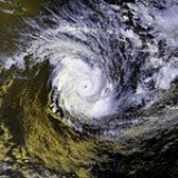
Cyclone Bola was one of the costliest cyclones in the history of New Zealand, causing severe damage as an extratropical cyclone
when it passed near the country in March 1988. It formed on February 24 to the north of Fiji
, and tracking generally southwestward it reached hurricane-force winds
near Vanuatu
on February 28. The next day it generated peak wind velocities of 195 km/h (120 mph), though it quickly weakened as it accelerated southward. On March 4 Bola transitioned into an extratropical storm, passing to the north of the North Island
of New Zealand on March 8. It weakened further and was absorbed by a stationary trough
near the South Island
on March 12.
The cyclone first affected Fiji, where it produced gale force winds and strong waves. In Vanuatu, Bola dropped heavy rainfall, which destroyed two bridges and caused severe damage to islands in the group. Bola caused severe damage to the North Island of New Zealand, where heavy rainfall peaked at 917 mm (36.1 in) in Gisborne Region
. Damage totaled over $82 million (1988 USD, $ USD). Three people were killed due to flooding, and hundreds were evacuated when a swollen river threatened a town. The name Bola was later retired, meaning it will not be used again within the same basin.
in Nadi, Fiji (RSMC Nadi). The storm turned westward on February 25, and to the southwest the next day. Bola gradually intensified as its movement slowed and stalled, and on February 28 the Joint Typhoon Warning Center
(JTWC) assessed the cyclone as reaching hurricane-force winds
near Vanuatu. It turned to a southeast drift before executing a small cyclonic loop on March 1, during which the JTWC estimated Bola attained peak winds of 195 km/h (120 mph). At the same time, its minimum central pressure
was estimated at 940 mbar
.
After reaching peak intensity, Cyclone Bola quickly weakened as it accelerated southeastward toward a frontal trough
. On March 3, its winds dropped below hurricane-force, and it gradually lost its tropical characteristics
. The structure became asymmetric, with a large band of clouds extending well south of the circulation. By March 4, Bola had completed the transition into an extratropical cyclone. Which turned south and began to affect the North Island of New Zealand on March 6. A building ridge
of high pressure to its south caused the extratropical remnants of Bola to slow and turn to the west on March 7. The next day, the storm passed about 110 km (70 mi) north of the North Island. Around the same time, the storm began slowly filling, meaning the low pressure area
associated with Bola was losing its identity. It turned southward on March 9, and on March 12 was absorbed by a stationary trough in the Westerlies
near the western coast of the South Island
.
force winds and waves of up to 5 m (16.4 ft), with severe damage reported throughout the archipelago.
Cyclone Bola remained near Vanuatu for about a week, during which it reached its peak intensity while executing a cyclonic loop. The most affected locations were Epi
island, the Shepherd Islands
, and the islands in Malampa Province
, and throughout the country the cyclone affected more than 15,000 people and 3,000 houses. In a five day period the cyclone dropped about 450 mm (17.7 in) of rainfall. Two bridges on Malakula
were destroyed, and several other bridges were flooded or damaged. The passage of the cyclone also left several buildings, roads, and crop fields damaged.
. Heavy rainfall totals of up to and over 300 mm (12 in) were observed in the regions of Auckland
and Northland. The cyclone is the largest to be recorded in 93 years of rainfall records. As such, it had a large and lasting effect on the rivers of the area when it deposited a large amount of sediment, as recorded in the sedimentary record of Lake Tutira
. Shortly prior to losing its identity, the remnants of Bola also dropped 100–200 mm (4–8 in) of precipitation on the South Island
of New Zealand.
Storm damage was heaviest in Gisborne, where rain destroyed or damaged several roads and bridges. Three days of continuous rainfall led to mudslides, flooding, and erosion. Flooding killed three people when a car was swept away. In Te Karaka in Gisborne, a flooded river forced 500 residents to evacuate. A total of 1,765 farmers were affected by the flooding, accounting for about 3,600 hectares (8,900 acres) of damaged crop fields and about $ in crop damage (1988 NZD, $ 1988 USD $ USD). Water supplies were disrupted in two cities due to flooding. Rainfall in Northland Region caused flooding and outages to telephone and power. Additionally, beginning on about 6 March, the cyclone began affecting the North Island with strong easterly winds of over hurricane force, caused by the interaction between the extratropical remnants of Bola and a ridge of high pressure to its south. The winds damaged a few homes, including some in which the roofs were damaged or destroyed. In addition, the strong winds downed several trees, and at the same time, erosion and landslides left hillsides bare without grass or trees.
provided manpower assistance to 11 islands in the country. Reconstruction costs in Vanuatu totalled about $5 million (1988 USD, $ USD), which was about 10 percent of the country's national budget.
After the passage of the storm, four towns in New Zealand declared states of emergency. The New Zealand government provided about $80 million (1988 NZD) to the east coast region of the North Island for assisting in cyclone damage. $8 million was used to create an East Coast Forestry Conservation Scheme, which was set to protect forests and prevent erosion. A study was taken five years after the storm, consisting of a group of 112 people who were evacuated or received monetary assistance in response to the cyclone; the study showed 12% of the respondents as experiencing Posttraumatic stress disorder, of which they reported a general lack of assistance and public support.
Extratropical cyclone
Extratropical cyclones, sometimes called mid-latitude cyclones or wave cyclones, are a group of cyclones defined as synoptic scale low pressure weather systems that occur in the middle latitudes of the Earth having neither tropical nor polar characteristics, and are connected with fronts and...
when it passed near the country in March 1988. It formed on February 24 to the north of Fiji
Fiji
Fiji , officially the Republic of Fiji , is an island nation in Melanesia in the South Pacific Ocean about northeast of New Zealand's North Island...
, and tracking generally southwestward it reached hurricane-force winds
Tropical cyclone scales
Tropical systems are officially ranked on one of several tropical cyclone scales according to their maximum sustained winds and in what oceanic basin they are located...
near Vanuatu
Vanuatu
Vanuatu , officially the Republic of Vanuatu , is an island nation located in the South Pacific Ocean. The archipelago, which is of volcanic origin, is some east of northern Australia, northeast of New Caledonia, west of Fiji, and southeast of the Solomon Islands, near New Guinea.Vanuatu was...
on February 28. The next day it generated peak wind velocities of 195 km/h (120 mph), though it quickly weakened as it accelerated southward. On March 4 Bola transitioned into an extratropical storm, passing to the north of the North Island
North Island
The North Island is one of the two main islands of New Zealand, separated from the much less populous South Island by Cook Strait. The island is in area, making it the world's 14th-largest island...
of New Zealand on March 8. It weakened further and was absorbed by a stationary trough
Trough (meteorology)
A trough is an elongated region of relatively low atmospheric pressure, often associated with fronts.Unlike fronts, there is not a universal symbol for a trough on a weather chart. The weather charts in some countries or regions mark troughs by a line. In the United States, a trough may be marked...
near the South Island
South Island
The South Island is the larger of the two major islands of New Zealand, the other being the more populous North Island. It is bordered to the north by Cook Strait, to the west by the Tasman Sea, to the south and east by the Pacific Ocean...
on March 12.
The cyclone first affected Fiji, where it produced gale force winds and strong waves. In Vanuatu, Bola dropped heavy rainfall, which destroyed two bridges and caused severe damage to islands in the group. Bola caused severe damage to the North Island of New Zealand, where heavy rainfall peaked at 917 mm (36.1 in) in Gisborne Region
Gisborne, New Zealand
-Economy:The harbour was host to many ships in the past and had developed as a river port to provide a more secure location for shipping compared with the open roadstead of Poverty Bay which can be exposed to southerly swells. A meat works was sited beside the harbour and meat and wool was shipped...
. Damage totaled over $82 million (1988 USD, $ USD). Three people were killed due to flooding, and hundreds were evacuated when a swollen river threatened a town. The name Bola was later retired, meaning it will not be used again within the same basin.
Meteorological history
A tropical disturbance began organizing about 870 km (540 mi) north of Fiji on February 23, 1988. It tracked southwestward, intensifying into a tropical storm on 24 February; the system was named Tropical Storm Bola by the Regional Specialized Meteorological CentreRegional Specialized Meteorological Centre
A Regional Specialized Meteorological Centre is responsible for the distribution of information, advisories, and warnings regarding the specific program they have a part of, agreed by consensus at the World Meteorological Organization as part of the World Weather Watch.-Tropical...
in Nadi, Fiji (RSMC Nadi). The storm turned westward on February 25, and to the southwest the next day. Bola gradually intensified as its movement slowed and stalled, and on February 28 the Joint Typhoon Warning Center
Joint Typhoon Warning Center
The Joint Typhoon Warning Center is a joint United States Navy – United States Air Force task force located at the Naval Maritime Forecast Center in Pearl Harbor, Hawaii...
(JTWC) assessed the cyclone as reaching hurricane-force winds
Tropical cyclone scales
Tropical systems are officially ranked on one of several tropical cyclone scales according to their maximum sustained winds and in what oceanic basin they are located...
near Vanuatu. It turned to a southeast drift before executing a small cyclonic loop on March 1, during which the JTWC estimated Bola attained peak winds of 195 km/h (120 mph). At the same time, its minimum central pressure
Atmospheric pressure
Atmospheric pressure is the force per unit area exerted into a surface by the weight of air above that surface in the atmosphere of Earth . In most circumstances atmospheric pressure is closely approximated by the hydrostatic pressure caused by the weight of air above the measurement point...
was estimated at 940 mbar
Bar (unit)
The bar is a unit of pressure equal to 100 kilopascals, and roughly equal to the atmospheric pressure on Earth at sea level. Other units derived from the bar are the megabar , kilobar , decibar , centibar , and millibar...
.
After reaching peak intensity, Cyclone Bola quickly weakened as it accelerated southeastward toward a frontal trough
Cold front
A cold front is defined as the leading edge of a cooler mass of air, replacing a warmer mass of air.-Development of cold front:The cooler and denser air wedges under the less-dense warmer air, lifting it...
. On March 3, its winds dropped below hurricane-force, and it gradually lost its tropical characteristics
Tropical cyclone
A tropical cyclone is a storm system characterized by a large low-pressure center and numerous thunderstorms that produce strong winds and heavy rain. Tropical cyclones strengthen when water evaporated from the ocean is released as the saturated air rises, resulting in condensation of water vapor...
. The structure became asymmetric, with a large band of clouds extending well south of the circulation. By March 4, Bola had completed the transition into an extratropical cyclone. Which turned south and began to affect the North Island of New Zealand on March 6. A building ridge
Ridge (meteorology)
A ridge is an elongated region of relatively high atmospheric pressure, the opposite of a trough....
of high pressure to its south caused the extratropical remnants of Bola to slow and turn to the west on March 7. The next day, the storm passed about 110 km (70 mi) north of the North Island. Around the same time, the storm began slowly filling, meaning the low pressure area
Low pressure area
A low-pressure area, or "low", is a region where the atmospheric pressure at sea level is below that of surrounding locations. Low-pressure systems form under areas of wind divergence which occur in upper levels of the troposphere. The formation process of a low-pressure area is known as...
associated with Bola was losing its identity. It turned southward on March 9, and on March 12 was absorbed by a stationary trough in the Westerlies
Westerlies
The Westerlies, anti-trades, or Prevailing Westerlies, are the prevailing winds in the middle latitudes between 30 and 60 degrees latitude, blowing from the high pressure area in the horse latitudes towards the poles. These prevailing winds blow from the west to the east, and steer extratropical...
near the western coast of the South Island
South Island
The South Island is the larger of the two major islands of New Zealand, the other being the more populous North Island. It is bordered to the north by Cook Strait, to the west by the Tasman Sea, to the south and east by the Pacific Ocean...
.
Impact
Fiji and Vanuatu
As a tropical cyclone, Bola first impacted Fiji shortly after forming while passing to the northwest, and again as it was weakening after peak intensity to the southwest of the island. It brushed the country with galeGale
A gale is a very strong wind. There are conflicting definitions of how strong a wind must be to be considered a gale. The U.S. government's National Weather Service defines a gale as 34–47 knots of sustained surface winds. Forecasters typically issue gale warnings when winds of this strength are...
force winds and waves of up to 5 m (16.4 ft), with severe damage reported throughout the archipelago.
Cyclone Bola remained near Vanuatu for about a week, during which it reached its peak intensity while executing a cyclonic loop. The most affected locations were Epi
Epi (island)
Epi is the name of an island in Vanuatu, at the north end of the Shepherd Islands. It is in Shefa Province. It is long northwest-southeast, and wide, with an area of . Its shoreline measures 130 km...
island, the Shepherd Islands
Shepherd Islands
The Shepherd Islands are a group of islands lying between the larger islands of Epi and Éfaté, in the Shefa province of Vanuatu. The aggregate land area is 88 km². At the 2009 census the population numbered 3634....
, and the islands in Malampa Province
Malampa Province
Malampa is a province of Vanuatu, made up of three main islands, Malakula, Ambrym and Paama, from which the province's name is derived. It includes a number of other islands – the small islands of Uripiv, Norsup, Rano, Wala, Atchin and Vao off the coast of Malakula, and the volcanic island of...
, and throughout the country the cyclone affected more than 15,000 people and 3,000 houses. In a five day period the cyclone dropped about 450 mm (17.7 in) of rainfall. Two bridges on Malakula
Malakula
Malakula Island , also spelled Malekula, is the second-largest island in the nation of Vanuatu, in the Pacific Ocean region of Melanesia...
were destroyed, and several other bridges were flooded or damaged. The passage of the cyclone also left several buildings, roads, and crop fields damaged.
New Zealand
Cyclone Bola created some of the heaviest rainfall totals for a single storm in the history of New Zealand, with some locations receiving more than half of their annual rainfall totals from the storm. While the cyclone passed north of the island, a strong easterly flow over the North Island contained the interaction between moist air from Bola and drier air from the ridge to its southeast. In the Gisborne region, the flow resulted in the heaviest rainfall totals, when the moisture ascended over the region's western mountainous areas and condensed into precipitation. One station recorded 419 mm (16.5 in) in a 24 hour period. The maximum rainfall total attributed to the storm was 917 mm (36.1 in), reported at a station near Tolaga BayTolaga Bay
Tolaga Bay is both a bay and small town on the East Coast of New Zealand's North Island located 45 kilometres northeast of Gisborne and 30 kilometres south of Tokomaru Bay.It was named Tolaga Bay by Lt...
. Heavy rainfall totals of up to and over 300 mm (12 in) were observed in the regions of Auckland
Auckland Region
The Auckland Region was one of the sixteen regions of New Zealand, named for the city of Auckland, the country's largest urban area. With one third of the nation's residents, it was by far the biggest population and economy of any region of New Zealand, but the second-smallest land area.On 1...
and Northland. The cyclone is the largest to be recorded in 93 years of rainfall records. As such, it had a large and lasting effect on the rivers of the area when it deposited a large amount of sediment, as recorded in the sedimentary record of Lake Tutira
Lake Tutira
Lake Tutira is a body of water in northeastern Hawke's Bay, New Zealand.Much of the area was surveyed by Herbert Guthrie-Smith, who farmed 60,000 acres surrounding the lake. Guthrie-Smith, a naturalist, published Tutira: the story of a New Zealand sheep station in 1921...
. Shortly prior to losing its identity, the remnants of Bola also dropped 100–200 mm (4–8 in) of precipitation on the South Island
South Island
The South Island is the larger of the two major islands of New Zealand, the other being the more populous North Island. It is bordered to the north by Cook Strait, to the west by the Tasman Sea, to the south and east by the Pacific Ocean...
of New Zealand.
Storm damage was heaviest in Gisborne, where rain destroyed or damaged several roads and bridges. Three days of continuous rainfall led to mudslides, flooding, and erosion. Flooding killed three people when a car was swept away. In Te Karaka in Gisborne, a flooded river forced 500 residents to evacuate. A total of 1,765 farmers were affected by the flooding, accounting for about 3,600 hectares (8,900 acres) of damaged crop fields and about $ in crop damage (1988 NZD, $ 1988 USD $ USD). Water supplies were disrupted in two cities due to flooding. Rainfall in Northland Region caused flooding and outages to telephone and power. Additionally, beginning on about 6 March, the cyclone began affecting the North Island with strong easterly winds of over hurricane force, caused by the interaction between the extratropical remnants of Bola and a ridge of high pressure to its south. The winds damaged a few homes, including some in which the roofs were damaged or destroyed. In addition, the strong winds downed several trees, and at the same time, erosion and landslides left hillsides bare without grass or trees.
Aftermath
In Vanuatu, cyclone victims received food and emergency aid following the storm. Australian patrol boat HMAS CessnockHMAS Cessnock (FCPB 210)
HMAS Cessnock , named for the city of Cessnock, New South Wales was a Fremantle class patrol boat of the Royal Australian Navy .-Design and construction:...
provided manpower assistance to 11 islands in the country. Reconstruction costs in Vanuatu totalled about $5 million (1988 USD, $ USD), which was about 10 percent of the country's national budget.
After the passage of the storm, four towns in New Zealand declared states of emergency. The New Zealand government provided about $80 million (1988 NZD) to the east coast region of the North Island for assisting in cyclone damage. $8 million was used to create an East Coast Forestry Conservation Scheme, which was set to protect forests and prevent erosion. A study was taken five years after the storm, consisting of a group of 112 people who were evacuated or received monetary assistance in response to the cyclone; the study showed 12% of the respondents as experiencing Posttraumatic stress disorder, of which they reported a general lack of assistance and public support.
See also
- List of tropical cyclones
- Geography of New ZealandGeography of New ZealandThe geography of New Zealand encompasses two main islands and a number of smaller islands, located near the centre of the water hemisphere. New Zealand varies in climate, from cold and wet to dry and to subtropical in some areas...