

Cup and ring mark
Encyclopedia
Prehistoric art
In the history of art, prehistoric art is all art produced in preliterate, prehistorical cultures beginning somewhere in very late geological history, and generally continuing until that culture either develops writing or other methods of record-keeping, or it makes significant contact with another...
found mainly in Atlantic Europe (Northern England, Scotland, Ireland, Brittany , Portugal and Galicia (North West Spain)) and Mediterranean Europe (North West Italy, Thessalia Central Greece, Switzerland) although similar forms are also found throughout the world including Mexico
Mexico
The United Mexican States , commonly known as Mexico , is a federal constitutional republic in North America. It is bordered on the north by the United States; on the south and west by the Pacific Ocean; on the southeast by Guatemala, Belize, and the Caribbean Sea; and on the east by the Gulf of...
, Brazil
Brazil
Brazil , officially the Federative Republic of Brazil , is the largest country in South America. It is the world's fifth largest country, both by geographical area and by population with over 192 million people...
, Greece
Greece
Greece , officially the Hellenic Republic , and historically Hellas or the Republic of Greece in English, is a country in southeastern Europe....
, and India
India
India , officially the Republic of India , is a country in South Asia. It is the seventh-largest country by geographical area, the second-most populous country with over 1.2 billion people, and the most populous democracy in the world...
, where the oldest cup marks so far recorded are to be found in the Paeleolithic cave shelter site of Chattan.
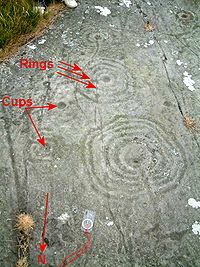
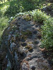
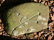
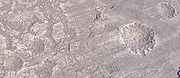
They consist of a concave depression, no more than a few centimetres across, pecked into a rock surface and often surrounded by concentric circles also etched into the stone. Sometimes a linear channel called a gutter leads out from the middle.
The decoration occurs as a petroglyph
Petroglyph
Petroglyphs are pictogram and logogram images created by removing part of a rock surface by incising, picking, carving, and abrading. Outside North America, scholars often use terms such as "carving", "engraving", or other descriptions of the technique to refer to such images...
on natural boulders and outcrops and also as an element of megalithic art
Megalithic art
Megalithic art refers to the use of large stones as an artistic medium. Although some modern artists and sculptors make use of large stones in their work, the term is more generally used to describe art carved onto megaliths in prehistoric Europe....
on purposely worked megalith
Megalith
A megalith is a large stone that has been used to construct a structure or monument, either alone or together with other stones. Megalithic describes structures made of such large stones, utilizing an interlocking system without the use of mortar or cement.The word 'megalith' comes from the Ancient...
s such as the slab cist
Cist
A cist from ) is a small stone-built coffin-like box or ossuary used to hold the bodies of the dead. Examples can be found across Europe and in the Middle East....
s of the Food Vessel culture, some stone circle
Stone circle
A stone circle is a monument of standing stones arranged in a circle. Such monuments have been constructed across the world throughout history for many different reasons....
s and passage grave
Passage grave
thumb|250px|right|A simple passage tomb in [[Carrowmore]] near [[Sligo]] in IrelandA passage grave or passage tomb consists of a narrow passage made of large stones and one or multiple burial chambers covered in earth or stone. Megaliths are usually used in the construction of passage tombs, which...
s such as the clava tombs and on the capstones at Newgrange
Newgrange
Newgrange is a prehistoric monument located in County Meath, on the eastern side of Ireland, about one kilometre north of the River Boyne. It was built around 3200 BC , during the Neolithic period...
.
Italy
Numerous cup marks have been discovered in Val CamonicaVal Camonica
Val Camonica is one of the largest valleys of the central Alps, in eastern Lombardy, about 90 km long. It starts from the Tonale Pass, at 1883 metres above sea level and ends at Corna Trentapassi, in the comune of Pisogne, near Lake Iseo...
(Italy
Italy
Italy , officially the Italian Republic languages]] under the European Charter for Regional or Minority Languages. In each of these, Italy's official name is as follows:;;;;;;;;), is a unitary parliamentary republic in South-Central Europe. To the north it borders France, Switzerland, Austria and...
) associated to rock drawings
Rock Drawings in Valcamonica
The stone carvings of Val Camonica constitute one of the largest collections of prehistoric petroglyphs in the world. The collection was recognized by Unesco in 1979 and was Italy's first recognized World Heritage Site...
.
Many engraved blocks are visible in the north west region of Italy (Piedmont
Piedmont
Piedmont is one of the 20 regions of Italy. It has an area of 25,402 square kilometres and a population of about 4.4 million. The capital of Piedmont is Turin. The main local language is Piedmontese. Occitan is also spoken by a minority in the Occitan Valleys situated in the Provinces of...
): The best known places are "Val Susa", "La Bessa" and "Valchiusella".
Galicia (Spain)
Similar patterns are known in Galicia, which has given them the name of 'Galician style'. These types, the cup-and-ring, cup-and-ring with gutter and the gapped concentric circles motifs are shared between this part of IberiaIberian Peninsula
The Iberian Peninsula , sometimes called Iberia, is located in the extreme southwest of Europe and includes the modern-day sovereign states of Spain, Portugal and Andorra, as well as the British Overseas Territory of Gibraltar...
and the British Isles
British Isles
The British Isles are a group of islands off the northwest coast of continental Europe that include the islands of Great Britain and Ireland and over six thousand smaller isles. There are two sovereign states located on the islands: the United Kingdom of Great Britain and Northern Ireland and...
, manifesting, together with other cultural expressions like megalith
Megalith
A megalith is a large stone that has been used to construct a structure or monument, either alone or together with other stones. Megalithic describes structures made of such large stones, utilizing an interlocking system without the use of mortar or cement.The word 'megalith' comes from the Ancient...
s or Bronze Age culture
Atlantic Bronze Age
The Atlantic Bronze Age is a cultural complex of the Bronze Age period of approximately 1300–700 BC that includes different cultures in Portugal, Andalusia, Galicia, Armorica and the British Isles.-Trade:...
, a cultural link along the coasts of Atlantic Europe
Atlantic Europe
Atlantic Europe is a geographical and anthropological term for the western portion of Europe which borders the Atlantic Ocean. The term may refer to the idea of Atlantic Europe as a cultural unit and/or as an biogeographical region....
.
United Kingdom
Precisely dating megalithic art is difficult as even if the megalithic monument can be dated, the art may be a later addition. The Hunterheugh CragsHunterheugh Crags
Hunterheugh Crags are part of the Fellsandstone escarpment, north west of Alnwick, Northumberland, England and from the coast. The site is barren moorland, although prior to the Bronze Age it is likely to have been thickly forested with broadleaf deciduous trees...
cup and ring marks near Alnwick
Alnwick
Alnwick is a small market town in north Northumberland, England. The town's population was just over 8000 at the time of the 2001 census and Alnwick's district population was 31,029....
in Northumberland
Northumberland
Northumberland is the northernmost ceremonial county and a unitary district in North East England. For Eurostat purposes Northumberland is a NUTS 3 region and is one of three boroughs or unitary districts that comprise the "Northumberland and Tyne and Wear" NUTS 2 region...
have recently been demonstrated to date back into the Early Neolithic through their stratigraphic
Stratigraphy
Stratigraphy, a branch of geology, studies rock layers and layering . It is primarily used in the study of sedimentary and layered volcanic rocks....
relationship with other, datable features. Some cup marks have been found in Iron age
Iron Age
The Iron Age is the archaeological period generally occurring after the Bronze Age, marked by the prevalent use of iron. The early period of the age is characterized by the widespread use of iron or steel. The adoption of such material coincided with other changes in society, including differing...
contexts but these may represent re-used stones.
Where they are etched onto natural, flat stone it has been observed that they seem to incorporate the natural surface of the rock. Those at Hunterheugh are mostly connected to one another by gutters that can channel rainwater from one to the next, down the sloping top of the stone.
It has been suggested by archaeologist Clive Waddington that the initial Early Neolithic impetus to create the marks was forgotten and that the practice fell into abeyance until a second phase of creation continued the basic tradition but with less precision and more variability in design. The markers of this second phase moved the art from natural stones to megaliths as its symbolism was reinterpreted by Later Neolithic and Early Bronze Age people.
Their purpose is unknown although some may be connected with natural stone outcrops exploited by Neolithic peoples to make polished stone axes. A religious purpose has been suggested.
Alexander Thom
Alexander Thom
Alexander "Sandy" Thom was a Scottish engineer most famous for his theory of the Megalithic yard, categorization of stone circles and his studies of Stonehenge and other archaeological sites.- Life and work :...
suggested on a BBC
BBC
The British Broadcasting Corporation is a British public service broadcaster. Its headquarters is at Broadcasting House in the City of Westminster, London. It is the largest broadcaster in the world, with about 23,000 staff...
television
Television
Television is a telecommunication medium for transmitting and receiving moving images that can be monochrome or colored, with accompanying sound...
documentary called "Cracking the Stone Age Code" in 1970, "I have an idea, entirely nebulous at the moment, that the cup and ring markings were a method of recording, of writing, and that they may indicate, once we can read them, what a particular stone was for. We have seen the cup and ring markings on the stone at Temple Wood
Kilmartin Glen
Kilmartin Glen is an area in Argyll not far from Kintyre, which has one of the most important concentrations of Neolithic and Bronze Age remains in Scotland. The glen is located between Oban and Lochgilphead, surrounding the village of Kilmartin....
, and that's on the main stone but we can't interpret them ...yet". He created diagrams and carried out analysis of over 50 of the cup and ring markings from which he determined a length he termed the Megalithic Inch
Megalithic Yard
A Megalithic Yard is a unit of measurement, about , that some researchers believe was used in the construction of megalithic structures. The proposal was made by Alexander Thom as a result of his surveys of 600 megalithic sites in England, Scotland, Wales and Britanny...
(MI). This whole idea has been ignored almost completely apart from a critical analysis carried out by Alan Davies in the 1980s
1980s
File:1980s decade montage.png|thumb|400px|From left, clockwise: The first Space Shuttle, Columbia, lifted off in 1981; American President Ronald Reagan and Soviet leader Mikhail Gorbachev eased tensions between the two superpowers, leading to the end of the Cold War; The Fall of the Berlin Wall in...
, who covered only English sites with cup and ring marks. He suggested "strongest indications... ...towards the use of a quantum close in value to 5 MI at certain sites" and that "the apparent quantum seems strongly associated with ringed cups". Davies made an initial effort to build on Thom's start, and to answer the question he posed; "Why should a man spend hours - or rather days - cutting cups in a random fashion on a rock? It would indeed be a breakthrough if someone could crack the code of the cups."
Other examples of sites with cup and ring marks include :
- Chatton Sandyford cairnCairnCairn is a term used mainly in the English-speaking world for a man-made pile of stones. It comes from the or . Cairns are found all over the world in uplands, on moorland, on mountaintops, near waterways and on sea cliffs, and also in barren desert and tundra areas...
and Fowberry petrogyphs in NorthumberlandNorthumberlandNorthumberland is the northernmost ceremonial county and a unitary district in North East England. For Eurostat purposes Northumberland is a NUTS 3 region and is one of three boroughs or unitary districts that comprise the "Northumberland and Tyne and Wear" NUTS 2 region... - Backstone Beck petroglyphs on Ilkley MoorIlkley MoorIlkley Moor is part of Rombalds Moor, the moorland between Ilkley and Keighley in West Yorkshire, England, United Kingdom. The peat bogs rise to 402 m above sea level...
- Gardom's EdgeGardom's EdgeGardom's Edge is located near Baslow in Derbyshire, England.The shelf between Gardom's Edge and Birchen Edge is now moorland used for grazing sheep, but was inhabited and arably farmed duringthe Bronze Age...
in DerbyshireDerbyshireDerbyshire is a county in the East Midlands of England. A substantial portion of the Peak District National Park lies within Derbyshire. The northern part of Derbyshire overlaps with the Pennines, a famous chain of hills and mountains. The county contains within its boundary of approx... - Bachwen portal dolmen in North Wales
- Anderton, LancashireLancashireLancashire is a non-metropolitan county of historic origin in the North West of England. It takes its name from the city of Lancaster, and is sometimes known as the County of Lancaster. Although Lancaster is still considered to be the county town, Lancashire County Council is based in Preston...
- Dalladies long barrowLong barrowA long barrow is a prehistoric monument dating to the early Neolithic period. They are rectangular or trapezoidal tumuli or earth mounds traditionally interpreted as collective tombs...
, KincardineshireKincardineshireThe County of Kincardine, also known as Kincardineshire or The Mearns was a local government county on the coast of northeast Scotland... - Street House cairn in ClevelandCleveland, EnglandCleveland is an area in the north east of England. Its name means literally "cliff-land", referring to its hilly southern areas, which rise to nearly...
- Dalgarven MillDalgarven MillDalgarven Mill is near Kilwinning, in the Garnock Valley, North Ayrshire, Scotland and it is home to the Museum of Ayrshire Country Life and Costume. The watermill has been completely restored over a number of years and is run by the independent Dalgarven Mill Trust.The village of Dalgarven was...
, North Ayrshire - MauchlineMauchlineMauchline is a town in East Ayrshire, Scotland. In the 2001 census it had a recorded population of 4105. It lies by the Glasgow and South Western Railway line, 8 miles east-southeast of Kilmarnock and 11 miles northeast of Ayr. It is situated on a gentle slope about 1 mile from the River Ayr,...
Gorge, East Ayrshire - Brodick, Isle of ArranIsle of ArranArran or the Isle of Arran is the largest island in the Firth of Clyde, Scotland, and with an area of is the seventh largest Scottish island. It is in the unitary council area of North Ayrshire and the 2001 census had a resident population of 5,058...
- Blackshaw Hill, North Ayrshire
- KilmartinKilmartinKilmartin is a small village in Argyll and Bute, western Scotland. It is best known as the centre of Kilmartin Glen, an area with one of the richest concentrations of prehistoric monuments and historical sites in Scotland. It contains over 350 monuments within a 6 mile radius.-Kilmartin Parish...
, ArgyllArgyllArgyll , archaically Argyle , is a region of western Scotland corresponding with most of the part of ancient Dál Riata that was located on the island of Great Britain, and in a historical context can be used to mean the entire western coast between the Mull of Kintyre and Cape Wrath... - Achnabreck, Argyll (Proc Soc Antiq Scot 1970-71)
- Balblair, BeaulyBeaulyBeauly is a town of the Scottish county of Inverness-shire, on the River Beauly, 10 miles west of Inverness by the Far North railway line. Its population was 855 in 1901...
, nr. InvernessInvernessInverness is a city in the Scottish Highlands. It is the administrative centre for the Highland council area, and is regarded as the capital of the Highlands of Scotland...
Ireland
Work at Drumirril in County MonaghanCounty Monaghan
County Monaghan is a county in Ireland. It is part of the Border Region and is also located in the province of Ulster. It is named after the town of Monaghan. Monaghan County Council is the local authority for the county...
has uncovered Neolithic
Neolithic
The Neolithic Age, Era, or Period, or New Stone Age, was a period in the development of human technology, beginning about 9500 BC in some parts of the Middle East, and later in other parts of the world. It is traditionally considered as the last part of the Stone Age...
and early Bronze Age
Bronze Age
The Bronze Age is a period characterized by the use of copper and its alloy bronze as the chief hard materials in the manufacture of some implements and weapons. Chronologically, it stands between the Stone Age and Iron Age...
occupation evidence around the rock carvings there and this dating is generally accepted for most of the art. Another particularly rich source of cup marked boulders is the Derrynablaha townland on the Iveragh peninsula in county Kerry.
See also
- Rock Drawings in ValcamonicaRock Drawings in ValcamonicaThe stone carvings of Val Camonica constitute one of the largest collections of prehistoric petroglyphs in the world. The collection was recognized by Unesco in 1979 and was Italy's first recognized World Heritage Site...
- European Megalithic Culture
- PetroglyphPetroglyphPetroglyphs are pictogram and logogram images created by removing part of a rock surface by incising, picking, carving, and abrading. Outside North America, scholars often use terms such as "carving", "engraving", or other descriptions of the technique to refer to such images...
- PetrosomatoglyphPetrosomatoglyphA petrosomatoglyph is an image of parts of a human or animal body incised in rock. Many were created by Celtic peoples, such as the Picts, Scots, Irish, Cornish, Cumbrians, Bretons and Welsh. These representations date from the Early Middle Ages; others of uncertain purpose date back to megalithic...
- Dalgarven MillDalgarven MillDalgarven Mill is near Kilwinning, in the Garnock Valley, North Ayrshire, Scotland and it is home to the Museum of Ayrshire Country Life and Costume. The watermill has been completely restored over a number of years and is run by the independent Dalgarven Mill Trust.The village of Dalgarven was...
- BullaunBullaunA bullaun is the term used for the depression in a stone which is often water filled. Natural rounded boulders or pebbles may sit in the bullaun...
Further reading
- Beckensall, StanStan BeckensallStan Beckensall is an international rock art expert. He was the first male graduate of Keele University. He was a Station Education Officer in the Royal Air Force, on National Service. He became head of English at Ifield Grammar School, Crawley New Town, Sussex. He was head of English in a large...
and Laurie, Tim. 1998. Prehistoric Rock Art of County Durham, Swaledale and Wensleydale. County Durham Books. ISBN 1-897585-45-4 - Beckensall, Stan. 2001. Prehistoric Rock Art in Northumberland. Tempus Publishing. ISBN 0-7524-1945-5
- Beckensall, Stan. 2002. Prehistoric Rock Art in Cumbria. Tempus Publishing. ISBN 0-7524-2526-9
- Butter, Rachel. 1999. Kilmartin. Kilmartin House Trust. ISBN 0-9533674-0-1
- Hadingham, Evan. 1974. Ancient Carvings in Britain; A Mystery. Garnstone Press. ISBN 0-85511-391-X
- Morris, Ronald W.B. 1977. The Prehistoric Rock Art of Argyll. Dolphin Press. ISBN 0-85642-043-3
- Proc. Soc. Antiq. Scot. 1970-71. Vol.103. Pps.33-56.
- Papanikolaou Stelios. 600 Written Rocks. Channels of primeval knowledge Larissa <
> Second Revised Edition 2005 spapinvest@yahoo.gr ISBN 960-8439-21-3
External links
- British Rock Art Collection
- Era – England's Rock Art (Currently only covers Northumberland and County Durham)
- Rockart – Web Access to Rock Art: the Beckensall Archive of Northumberland Rock Art – University of Newcastle Upon Tyne
- El Laberinto Atlántico - Galician Rock Art
- BBC Archive - Chronicle | Cracking the Stone Age Code