
Heathcote, New South Wales
Encyclopedia
Heathcote is a suburb
, in southern
Sydney
, in the state of New South Wales
, Australia
. Heathcote is located 36 km south of the Sydney central business district
in the Sutherland Shire
.
Heathcote is bordered by Engadine
to the north and Waterfall
to the south. It is bounded by The Royal National Park to the east, and Heathcote National Park
to the west.
Heathcote is separated into two sections by the railway line. Heathcote East contains two of the schools and a sports oval
. Heathcote West is the larger side with the majority of residents. South Metropolitan Scouts Association has a camping ground and training centre in Boundary Road. A small group of shops is located on the western side, near the railway station on Princes Highway. The Sutherland Shire Emergency Services Centre is located on the eastern side, beside the railway station.
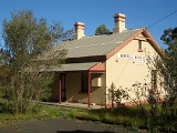
 Heathcote railway station opened in 1886. Heathcote Hall was built in Heathcote East in 1887 by Abel Harber, a brick manufacturer. This grand Victorian house included a tower, which was a symbol of wealth. Harber suffered heavy financial losses during the construction of the Imperial Arcade in Sydney and attempted to dispose of the property but the 1892 depression did not help. The Financial Institution became the house’s possessor and they arranged with George Adams of Tattersalls to organise a sweepstake with the house as a prize. The winner was Mr S. Gillett, a Sydney builder. The property was sold to Edmond Lamb Brown in 1901 and still stands today.
The Heathcote to Waterfall bushwalk became popular as a day outing in the 1930s, and the many tracks in Heathcote National Park and Royal National Park are used by Scouts Australia
as well as bushwalkers in general. There is a scout camping area called Camp Coutts in Heathcote National Park, adjacent to the suburb of Waterfall.
The Olympic Torch was carried through the shopping centre in 2000.
From Bottle Forest to Heathcote - the Sutherland Shire's First Settlement is the history of Heathcote which was written by Patrick Kennedy in 1999.
Heathcote Road meets the Princes Highway
at Heathcote. Heathcote Road is a major link to the north western suburbs, while the Princes Highway links Sydney and Wollongong
.
Over the last few years several people have been fatally struck by cars while crossing the highway. In July 2006, a 13-year-old boy was killed, crossing the highway with his bike at the traffic lights.
.
Heathcote has three public schools: Heathcote Public School, Heathcote East Public School, Heathcote High School
. The high school services Heathcote residents and also residents of the nearby suburbs of Engadine
, Helensburgh
, Waterfall
, Woronora Heights
and Stanwell Park
.
Heathcote high school is a leafy, modern high school with well educated teachers and high marks for the HSE. In 2010, a year 12 student got an outstanding mark of 99.09. The school also has a strict anti bullying policy.
Suburb
The word suburb mostly refers to a residential area, either existing as part of a city or as a separate residential community within commuting distance of a city . Some suburbs have a degree of administrative autonomy, and most have lower population density than inner city neighborhoods...
, in southern
Southern Sydney
This article refers to an area the same as a combination of St George and SutherlandSouthern Sydney is a general term which is used to describe the southern metropolitan area of Sydney, in the state of New South Wales, Australia....
Sydney
Sydney
Sydney is the most populous city in Australia and the state capital of New South Wales. Sydney is located on Australia's south-east coast of the Tasman Sea. As of June 2010, the greater metropolitan area had an approximate population of 4.6 million people...
, in the state of New South Wales
New South Wales
New South Wales is a state of :Australia, located in the east of the country. It is bordered by Queensland, Victoria and South Australia to the north, south and west respectively. To the east, the state is bordered by the Tasman Sea, which forms part of the Pacific Ocean. New South Wales...
, Australia
Australia
Australia , officially the Commonwealth of Australia, is a country in the Southern Hemisphere comprising the mainland of the Australian continent, the island of Tasmania, and numerous smaller islands in the Indian and Pacific Oceans. It is the world's sixth-largest country by total area...
. Heathcote is located 36 km south of the Sydney central business district
Sydney central business district
The Sydney central business district is the main commercial centre of Sydney, New South Wales, Australia. It extends southwards for about 3 kilometres from Sydney Cove, the point of first European settlement. Its north–south axis runs from Circular Quay in the north to Central railway station in...
in the Sutherland Shire
Sutherland Shire
The Sutherland Shire is a Local Government Area in the Southern Sydney region of Sydney, Australia. Geographically, it is the area to the south of Botany Bay and the Georges River...
.
Heathcote is bordered by Engadine
Engadine, New South Wales
Engadine is a suburb in southern Sydney, in the state of New South Wales, Australia. Engadine is located south of the Sydney central business district, in the local government area of the Sutherland Shire...
to the north and Waterfall
Waterfall, New South Wales
Waterfall is a small suburb in southern Sydney, in the state of New South Wales, Australia. Waterfall is located 38 kilometers south of the Sydney central business district in the Sutherland Shire....
to the south. It is bounded by The Royal National Park to the east, and Heathcote National Park
Heathcote National Park
Heathcote is a national park in New South Wales , 34 km southwest of Sydney. It lies west of the South Coast Line and the suburbs of Heathcote and Waterfall.-Description:...
to the west.
Heathcote is separated into two sections by the railway line. Heathcote East contains two of the schools and a sports oval
Oval
An oval is any curve resembling an egg or an ellipse, such as a Cassini oval. The term does not have a precise mathematical definition except in one area oval , but it may also refer to:* A sporting arena of oval shape** a cricket field...
. Heathcote West is the larger side with the majority of residents. South Metropolitan Scouts Association has a camping ground and training centre in Boundary Road. A small group of shops is located on the western side, near the railway station on Princes Highway. The Sutherland Shire Emergency Services Centre is located on the eastern side, beside the railway station.
History
Heathcote was originally known as Bottle Forest. There were fourteen town allotments in Bottle Forest in 1842, in what is now Heathcote East. In 1835 Surveyor-General Sir Thomas Mitchell (1792-1855) conducted a survey of the area and named it Heathcote, in honour of an officer who had fought with him during the Peninsula Wars against Napoleon.The Heathcote to Waterfall bushwalk became popular as a day outing in the 1930s, and the many tracks in Heathcote National Park and Royal National Park are used by Scouts Australia
Scouts Australia
Scouts Australia is an organisation for children and young adults from 6 to 26 years of age. Scouts Australia is part of the global Scouting movement and has been a national member of the World Organization of the Scout Movement since 1953...
as well as bushwalkers in general. There is a scout camping area called Camp Coutts in Heathcote National Park, adjacent to the suburb of Waterfall.
The Olympic Torch was carried through the shopping centre in 2000.
From Bottle Forest to Heathcote - the Sutherland Shire's First Settlement is the history of Heathcote which was written by Patrick Kennedy in 1999.
Transport
Heathcote railway station is on the City Rail Illawarra line. A bus service also links Engadine with Heathcote.Heathcote Road meets the Princes Highway
Princes Highway
The Princes Highway extends from Sydney to Port Augusta via the coast through the states of New South Wales, Victoria and South Australia, a distance of 1941 km or 1898 km via the former alignments of the highway ....
at Heathcote. Heathcote Road is a major link to the north western suburbs, while the Princes Highway links Sydney and Wollongong
Wollongong, New South Wales
Wollongong is a seaside city located in the Illawarra region of New South Wales, Australia. It lies on the narrow coastal strip between the Illawarra Escarpment and the Pacific Ocean, 82 kilometres south of Sydney...
.
Over the last few years several people have been fatally struck by cars while crossing the highway. In July 2006, a 13-year-old boy was killed, crossing the highway with his bike at the traffic lights.
Education
Heathcote's government schools are operated by the New South Wales Department of Education and TrainingNew South Wales Department of Education and Training
The New South Wales Department of Education and Communities, a department of the Government of New South Wales, is responsibile for primary schools, secondary schools and Technical and Further Education colleges...
.
Heathcote has three public schools: Heathcote Public School, Heathcote East Public School, Heathcote High School
Heathcote High School
Established in 1960, Heathcote High School is set in spacious grounds near the Royal National Park on the southern side of Sydney, Australia. It is a comprehensive co-educational school that educates around 1000 students in years 7-12 and has around 80 staff...
. The high school services Heathcote residents and also residents of the nearby suburbs of Engadine
Engadine, New South Wales
Engadine is a suburb in southern Sydney, in the state of New South Wales, Australia. Engadine is located south of the Sydney central business district, in the local government area of the Sutherland Shire...
, Helensburgh
Helensburgh, New South Wales
Helensburgh is a small town in New South Wales, Australia. Helensburgh is located 45 kilometres south of the Sydney central business district and north of Wollongong. Helensburgh is in the local government area of Wollongong City Council and marks the northern end of the Illawarra region...
, Waterfall
Waterfall, New South Wales
Waterfall is a small suburb in southern Sydney, in the state of New South Wales, Australia. Waterfall is located 38 kilometers south of the Sydney central business district in the Sutherland Shire....
, Woronora Heights
Woronora Heights, New South Wales
Woronora Heights is a suburb in southern Sydney, in the state of New South Wales, Australia. Woronora Heights is located 29 kilometres south of the Sydney central business district, in the local government area of the Sutherland Shire. Woronora is a separate suburb, to the north...
and Stanwell Park
Stanwell Park, New South Wales
Stanwell Park is a picturesque coastal village and northern suburb of Wollongong, New South Wales, Australia. It is the northernmost point of the Illawarra coastal strip and lies south of Sydney's Royal National Park. It is situated in a small valley between Bald Hill to the north, Stanwell Tops...
.
Heathcote high school is a leafy, modern high school with well educated teachers and high marks for the HSE. In 2010, a year 12 student got an outstanding mark of 99.09. The school also has a strict anti bullying policy.